|
|
Within the various "Images & Movies" pages and "TCTrak" window
Infrared images are displayed that have been enhanced using two primary enhancement
curves. These enhancements are used to highlight various different features
within the imagery, with each enhancement used for different purposes. These
two enhancements are named the "BD Curve" and "NHC Curve" enhancements.
BD Curve Enhancement
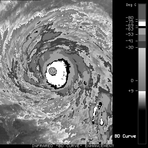
This enhancement is used a great deal in the research and tropical cyclone
forecasting communities who are interested in determining the intensity of
these storms. This enhancement is otherwise known as the "Dvorak
Hurricane Curve for Tropical Cyclone Classification", and is applied only
to infrared (11µm) imagery. The different black/white/gray ranges
represent different intensity classifications in the Subjective Dvorak
Intensity Classification Technique (NOAA Technical Report NESDIS 11, 1984).
The temperature values displayed on the image above are approximate, with the
absolute temperature ranges for each gray shade listed below :
         	  GRAY SHADE CODE         TEMPERATURE (Deg C)
         	  Warm Medium Gray          greater than +9
         	  Off White                  + 9 to -30
         	  Dark Gray                  -30 to -41
         	  Medium Gray                -41 to -53
         	  Light Gray                 -53 to -63
         	  Black                      -63 to -69
         	  White                      -69 to -75
         	  Cold Medium Gray           -75 to -80
         	  Cold Dary Gray            less than -81
NHC Curve Enhancement
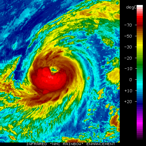
This enhancement is mainly utilized by the National Hurricane Center/
Tropical Prediction Center in Miami, Florida for enhancement of infrared (11µm)
imagery for television, newspaper, and internet displays. This enhancement
is typically provided for/by the media since they prefer to work with
color imagery rather than simple black & white enhanced imagery.
The temperature values listed on the image above are approximate values.
|
|
|
