|
|
Additional background information on the Saharan Air Layer (SAL) can be found at the
NOAA/AOML/Hurricane Research Division's
Tropical Cyclone FAQ page webpage.
Saharan Air Layer Outbreaks:
SAL outbreaks occur from the late spring through early fall and cover extensive
portions of the North Atlantic between the Sahara Desert, the West Indies and
the United States (e.g., Florida and Texas). These outbreaks move off the coast
of Africa every 3-5 days in a layer from ~550-850 hPa (~1,500-5500 m) and can
cover an area the size of the continental U.S.
(Movie Loop 1).
SAL activity
(described by the size and westward reach of the outbreaks) begins to rapidly
increase in early June, peaks from mid-June through late July, and begins to
subside in early August.
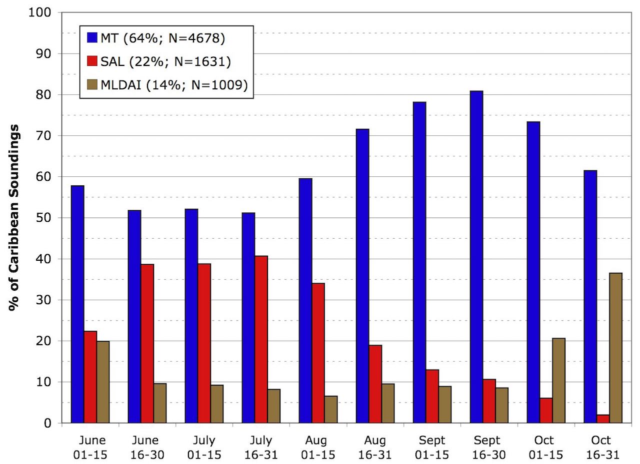
Figure 1
shows the mean occurrences of moist tropical
(MT), SAL, and midlatitude dry air intrusion (MLDAI) soundings in the Caribbean
region from June to October (Dunion 2011). During the summer, the SAL affects
~40% of all Caribbean rawinsonde soundings and on average, over 20% of soundings
during the peak months of the hurricane season (July-October, see
Figure 1
legend).
The Saharan Air Layer's Warm Temperatures:
The temperature at the base of the SAL (~800–900 hPa) is often 5°-10°C warmer
than the typical moist tropical sounding (Dunion 2011). While the warmth of the air
above the SAL’s base results from its origin over the Sahara, it is maintained by the
absorption of solar radiation by the SAL's suspended mineral dust. Although the effect
of the SAL's mineral dust on microphysical processes is not fully understood, the
warming it induces produces a strong temperature inversion at its base that can stabilize
the atmosphere and limit vertical motions through the SAL. The stability induced by this
temperature inversion is partially captured by the stability index called convective
inhibition (CIN), which describes how resistant the atmosphere is to vertical motions
and convection. On average, CIN is ~40% higher (more stable) in the SAL compared to
the typical moist tropical sounding (Dunion 2011). This enhanced stability acts to
suppress the formation of clouds and thunderstorms in SAL outbreaks.
The Saharan Air Layer's Dry Air:
The SAL’s dry air modifies very little as it travels across the North Atlantic and
is typically 50% drier than the moist tropical atmosphere (Dunion 2011). The extremely
dry air below the melting level in the SAL (~600-850 hPa) can act to suppress convection
by enhancing evaporatively driven downdrafts that act to stabilize the environment.
Satellite derived total precipitable water (TPW) is a useful tool for identifying dry
air masses like the SAL. Dunion (2011) found that 45 mm is a reasonable TPW threshold
value for discerning moist tropical air masses from environments with substantially
dry air in the lower to middle levels (e.g., the SAL and midlatitude dry air intrusions).
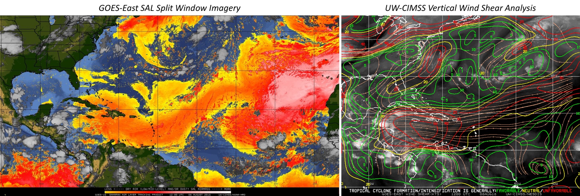
The Saharan Air Layer's Low to Mid-Level Easterly Jet:
The SAL's low to mid-level jet can dramatically increase the local vertical wind shear
in the North Atlantic. This 20-50 kt easterly jet is typically located in the 600-800 hPa
layer and can contribute vertical shear magnitudes as high as 25-75 kt.
Figure 2
shows an example of a SAL outbreak covering much of the Caribbean on August 8, 2018 and
includes a vertical wind shear analysis from UW-CIMSS. Shear values in the Caribbean
ranged from 30-50 kt and were being enhanced by a 30-35 kt SAL easterly jet.
Saharan Air Layer/Tropical Cyclone Interactions:
Tropical cyclones (TCs) and tropical disturbances can interact with the SAL in several ways.
Some storms are embedded in the SAL for their entire life cycle and often struggle to
intensify, while other can be overrun by the faster moving SAL. Some storms remain
insulated from the inhibiting effects of the SAL and intensify despite the hostile
environment surrounding them. Since SAL-TC interactions are complex and variable, specific
interactions need to be assessed in detail on a case by case basis.
Link to real-time products here.
References:
Dunion, J.P., 2011: Re-Writing the Climatology of the Tropical North Atlantic and
Caribbean Sea Atmosphere. J. Climate., 24, 893-908.
Dunion, J.P., and C.S. Velden, 2004: The impact of the Saharan
Air Layer on Atlantic tropical cyclone activity. Bull. Amer. Meteor. Soc., 85 no. 3, 353-365.
|
|
|
