Tropical Storm 01F_02


UW-CIMSS Automated Satellite-Based
Advanced Dvorak Technique (ADT)
Version 9.0
 
Current Intensity Analysis


                     UW - CIMSS                     
              ADVANCED DVORAK TECHNIQUE       
                    ADT-Version 9.0                
         Tropical Cyclone Intensity Algorithm       

             ----- Current Analysis ----- 
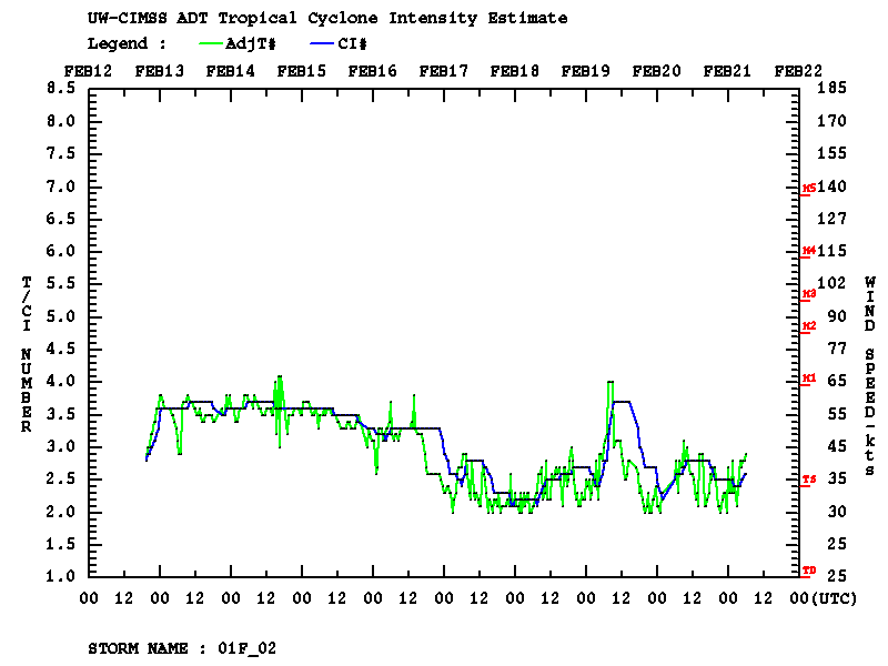
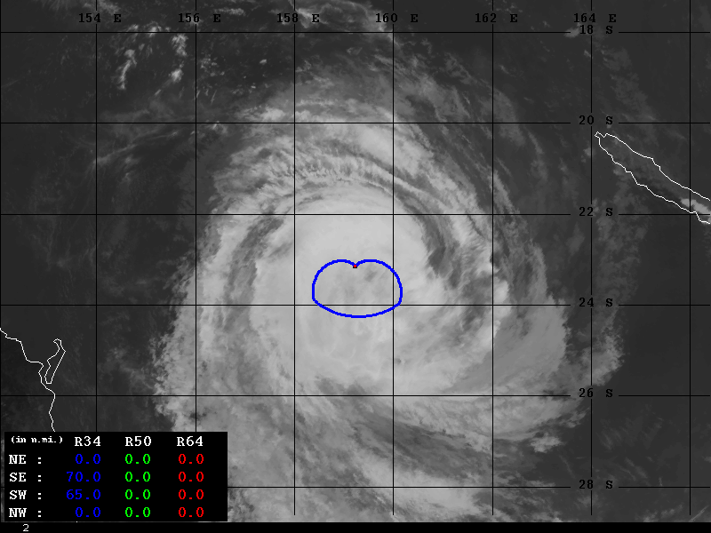
     Date :  21 FEB 2019    Time :   061000 UTC
      Lat :   23:07:54 S     Lon :  159:14:03 E

     
                CI# /Pressure/ Vmax
                2.6 / 996.1mb/ 37.0kt

     
             Final T#  Adj T#  Raw T# 
                2.6     2.9     3.1

     Latitude bias adjustment to MSLP :  +0.3mb

 Center Temp : -34.8C    Cloud Region Temp : -47.7C

 Scene Type : EMBEDDED CENTER CLOUD REGION 

 Subtropical Adjustment : OFF 

 Extratropical Adjustment : OFF 

 Positioning Method : FORECAST INTERPOLATION 

 Ocean Basin : WEST PACIFIC  
 Dvorak CI > MSLP Conversion Used : PACIFIC   

 Tno/CI Rules : Constraint Limits : 0.7T/6hr 
                   Weakening Flag : OFF   
           Rapid Dissipation Flag : OFF   

 Satellite Name :   HIM-8 
 Satellite Viewing Angle : 34.1 degrees 

****************************************************
History File Listing
Thresholds
(AtlEastCentPac / Other)
12.0 /10.0
ARCHER Information
PMW Information
Wind Radii Estimates
(based on Knaff et al. 2016)

(naut.mi.) R34 R50 R64
NE 0.0  0.0  0.0 
SE 70.0  0.0  0.0 
SW 65.0  0.0  0.0 
NW 0.0  0.0  0.0 
Parameters Used
RMW derived from Climatology
TC current intensity from ADT = 37.0 (kts)
TC forward speed from Forecast Interpolation = 6.6 (kts)
TC heading from Forecast Interpolation = 243.0 (deg)
Historical listing of wind radii values
Timeline plots of Wind Radii : 34kt   50kt   64kt
Satellite Imagery
Time Series
HTML5 Movie