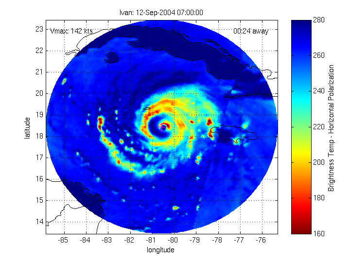
Example: Hurricane Ivan (2004): 12 Sept 0700 UTC -- 13 Sept 0000 UTC
|
MIMIC (Morphed Integrated Microwave Imagery at CIMSS) |
Product Description
The MIMIC product is a synthetic blend of tropical cyclone imagery from five low-Earth orbiting satellite instruments: the DMSP-13/14/15 SSM/I (85 GHz channel), the TRMM TMI (89 GHz channel) and the Aqua AMSR-E (85 GHz (A) channel). The signal from these channels is strongly attenuated from hydrometeors generated by deep convection, and therefore the imagery is often used as a proxy for the
distribution of precipitation. In the observation of tropical cyclones, the microwave signal can penetrate through obstructing cloud tops and uniquely reveal the structure of the eyewall.
The motivation for MIMIC derives from the need to visualize disparate (in time) satellite 85GHz imagery. A tropical cyclone is passed over by one of these satellites only every 4-5 hours on average, although the time gaps are irregular, ranging from 30 minutes to as much as 25 hours. MIMIC creates a morphed image animated sequence with 15 minute time steps (image frames). The 15 minute interval is flexible, but was chosen to be commensurate with commonly-available geo-satellite IR imagery, and also so the animation files can be kept at a reasonable size for easy on-line display purposes. An additional complication in interpreting the irregular "snapshot" 85GHz imagery of tropical cyclones is that the signals can represent both cells that are rapidly advecting, and stationary convective development, often overlapping. On the other hand, we can reasonably expect certain properties in the structure of a tropical cyclone to govern the changes between images such as nearly axial symmetry of the windspeed (i.e. 2D tangential windspeed as a function of radius (Holland, 1980)).
The current MIMIC algorithm strikes a balance between these different kinds of motion and imposes an advection scheme on the microwave signal that is a function of radius and reported maximum windspeed. The algorithm works by blending purely interpolated images into one another, but also by rotating the interpolated images throughout the blending process. This allows the visual effect of rapidly-emerging or advecting cells inside larger areas of convection, which is observed in surface radar rapid scan imagery but is not apparent at the original temporal resolution of the satellite microwave imagery. The angular velocity increases with proximity to the eye similar to the Holland profile, and the entire angular velocity function increases linearly with the reported maximum windspeed.
Because motion in the vicinity of the eyewall is typically faster than the temporal availability of the 85GHz imagery (cells/signals
frequently accomplish a full rotation between overpasses), the MIMIC algorithm makes a simple time-weighted interpolation between bounded images, with no advection, within a radius of 55 km (0.5 great circle degrees) from the rotational center. This assumption is valid only under continuous "regeneration" of signal between two "real" images at a fixed location with respect to the rotational center. Although this method does not represent every condition, it was found to be the most effective in general. A more robust morphing method for the eyewall is currently being investigated.
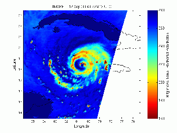
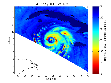
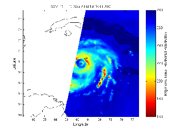
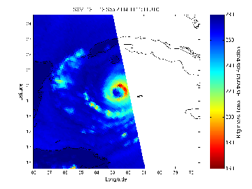
The example shown below illustrates an eyewall replacement cycle in Hurricane Ivan (2004). The morphed animation is built from the following four images, spaced apart by approximately 5.5, 1.5 and 10 hours.
|
Example: Hurricane Ivan (2004): 12 Sept 0700 UTC -- 13 Sept 0000 UTC |
|
|
|
|
| Aqua AMSR-E (85 GHz, Horizontal), 12 Sept 0724 UTC | TRMM TMI (89 GHz, Horizontal), 12 Sept 1252 UTC |
|
|
|
| DMSP-15 SSM/I (85 GHz, Horizontal), 12 Sept 1419 UTC | DMSP-13 SSM/I (85 GHz, Horizontal), 13 Sept 0011 UTC |
As an animated image sequence, the morphed product helps to visualize the timing of the eyewall replacement cycle during a west-northwest propagation of the cyclone.
|
|
|
Morph: 12 Sept 0700 UTC -- 13 Sept 0000 UTC |
The upper-left corner displays the NHC-reported maximum sustained winds interpolated in time, the upper-right corner displays the time to the nearest actual image either before or after (whichever is closer).
The mapped coastal boundaries are at their true geographical location; however, the land masses appear to drift in the animation as an artifact of the general cyclone-centered advection scheme.
Acknowledgment:
This project is supported financially by the Naval Research Laboratory's Marine Meteorology Division in Monterey, CA, and by the office of Naval Research, Program Element (PE-0602435N). The NRL Satellite Meteorological Applications Section has worked with CIMSS to create, validate and transition products and algorithms that enable the tropical cyclone community to extract reliable TC position, intensity and storm structure information via automated processing software.
Reference:
Holland, G., 1980, Analytic model of the wind and pressure profiles in hurricanes. Mon. Wea. Rev., 108, 1212-1218.
Comments welcome: wimmers at ssec.wisc.edu, chrisv at ssec.wis.edu