| Morphed Integrated
Microwave
Imagery at CIMSS - Total Precipitable Water (MIMIC-TPW) |
Return to MIMIC-TPW
Product Description
For more information, please refer to: Wimmers, A. J., C. S. Velden, 2011: Seamless Advective Blending of Total Precipitable Water Retrievals from Polar-Orbiting Satellites. J. Appl. Meteor. Climatol., 50, 1024-1036. doi: http://dx.doi.org/10.1175/2010JAMC2589.1
1. Introduction
In MIMIC-TPW, a data-blending technique combines disparate swaths of microwave observations from polar orbiting satellites in order to create near-seamless animations of advecting radiance features. It builds off of the methods used in MIMIC-TC, which depicts microwave imagery of tropical cyclones in regular time (Wimmers and Velden, 2007). MIMIC-TPW was originally developed as an experimental, near real time visualization tool utilizing microwave-derived moisture fields to follow the development and progression of cyclone-spawning easterly waves and the cyclone-impeding Saharan Air Layer in the North Atlantic Ocean. It has since been expanded to operate globally, with finer-resolution displays to fit the needs of our end-users. In this stage of development, we continue to make product modifications and improvements as we monitor the performance.2. Data
MIMIC-TPW uses retrieved total precipitable water values based on an algorithm developed by Alishouse et al. (1990), which derives these values from a linear function of 19, 22 and 37 GHz brightness temperatures available from passive microwave sensors aboard several polar orbiting satellite platforms. We currently use real-time data from the SSM/I sensor on the DMSP-13/14 satellites and the AMSR-E sensor on the Aqua satellite. Other options are not employed at this time because of our product's high sensitivity to biases between different retrievals of TPW and instrument noise.3. Swath advection
All TPW data must be processed so that they can be used concurrently at the hourly display times of the MIMIC-TPW product. To represent TPW at times several hours away from the retrieval time, we treat TPW as a purely conservative tracer advected by a lower-tropospheric mean layer wind using fields from the GFS global model. For example, the following DMSP/SSMI data swath crossed through the North Atlantic basin at approximately 1015 UTC (3 Sept 2004):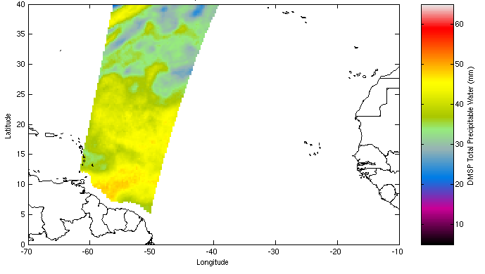
In the MIMIC-TPW algorithm, this swath is then advected backward and forward in time using the mean layer wind field in order to create synthetic hourly data corresponding to the original swath:
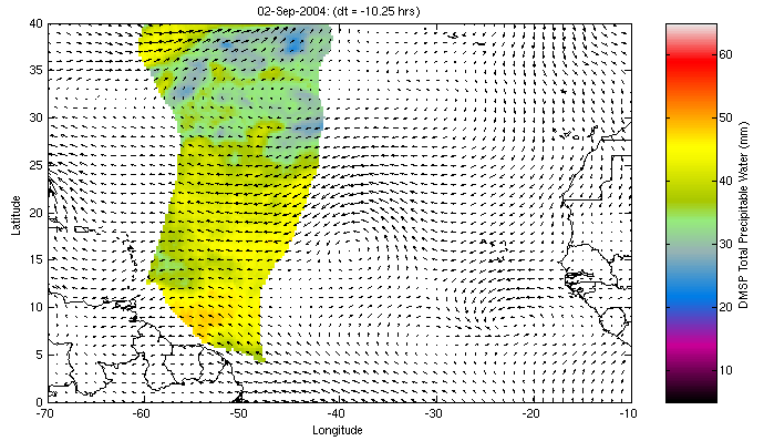
The mean layer wind field is commensurate in depth with the majority of columnar moisture over the tropical oceans (between 600 hPa and the surface).
Because the MIMIC-TPW product is real-time, we use forecast wind fields as well as analysis winds. However, over time the "older" advections in the dataset are recomputed as analysis winds come in to replace forecast winds.
Currently, we generate this synthetic hourly data for all times on the hour between +/- 16 hours from observation time of each swath. Thus for a given hour, a domain such as the North Atlantic basin has 20-30 synthetic swaths of data from which our algorithm can create a nearly complete composite image.
4. Composition
The final product is a simple composite of many advected TPW swaths over a selected domain. Every pixel on the final composited image is a time-weighted average between the synthetic data originating from the shortest timespans before and after the image time.The TPW retrieval algorithm does not produce TPW values over land. Without any further adjustments, the final product as described so far would show "shadows" of islands and continents advecting into the oceans. In order to eliminate these shadows, we apply an interpolation/extrapolation technique based on Bertalmío et al. (2000). The TPW retrieval algorithm also does not produce values in pixels with suspected precipitation. However, for our visualization purposes, we fill in these data gaps with high TPW values.
As stated above, this technique is highly sensitive to biases between the different satellite instruments' calibration and/or retrievals of TPW. Even slight differences between retrievals can create two easily discernable artifacts in the animation: 1) The appearance of data swath edges throughout the image domain, and 2) The apparent "pulsing" of various high-TPW areas, especially in areas of precipitation.
References
Bertalmío, M., A. Bertozzi, G. Sapiro, 2001: "Navier-Stokes, Fluid-Dynamics and Image and Video Inpainting", IEEE CVPR 2001, Hawaii, USA.Alishouse, J., S. Snyder, J. Vongsathorn, and R. Ferraro, 1990: Determination of oceanic total precipitable water from the SSM/I, IEEE Trans. Geosci. Remote Sens., 28, 811-816.
Wimmers, A. J. and C. S. Velden, 2007: MIMIC: A new approach to visualizing satellite microwave imagery of tropical cyclones. Bull. Amer. Meteor. Soc., 88, 1187-1196.
Created by Tony Wimmers and Chris Velden
Cooperative Institute for Meteorological Satellite Studies (CIMSS)
University of Wisconsin - Madison
10/25/07 Updated November, 2011