ImageAnimation
AniGIF
1km 2km
4km 8km
ADT
AMSU
SATCON
MIMIC
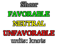
Shear
AiDT
D-MINT
D-PRINT
MPERC
ARCHER
Fcst Disc
RSMC Fcst