|
||
 |
D-MINT HISTORY FILE for 2024_07E
| Date | Time | MW Sensor | MSLP | Vmax (30th-70th percentile average) | Vmax 25th percentile | Vmax 75th percentile | Image |
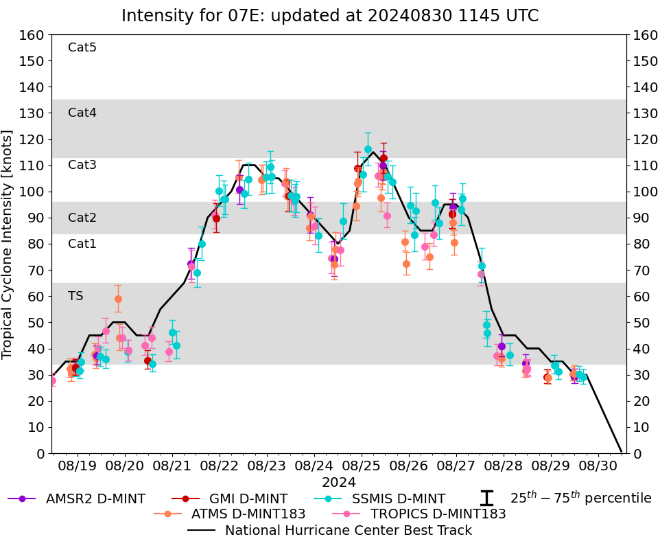
| 20240829 | 1625 UTC | SSMISF16 | 1011 hPa | 29 kts | 26 kts | 32 kts | 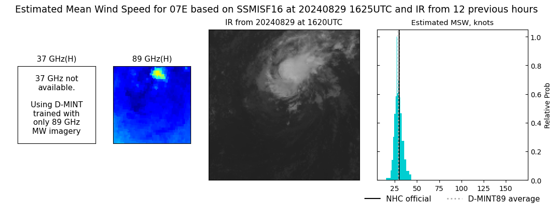 |
| 20240829 | 1413 UTC | SSMISF18 | 1010 hPa | 30 kts | 27 kts | 33 kts |  |
| 20240829 | 1201 UTC | ATMS-N21 | 1009 hPa | 30 kts | 28 kts | 34 kts | 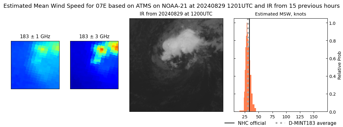 |
| 20240829 | 1200 UTC | AMSR2 | 1011 hPa | 29 kts | 27 kts | 32 kts | 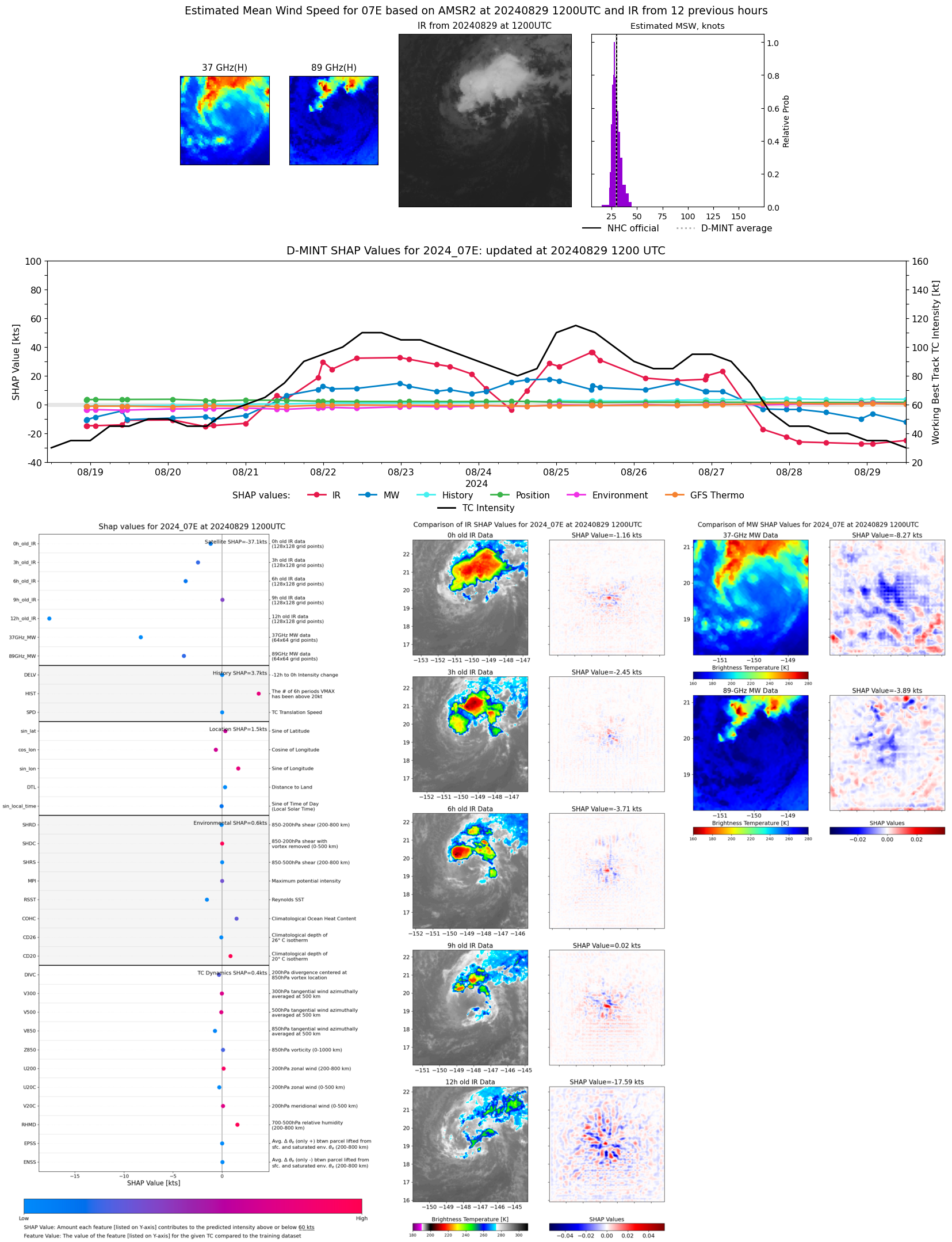 |
| 20240829 | 1110 UTC | ATMS-N20 | 1010 hPa | 30 kts | 28 kts | 33 kts | 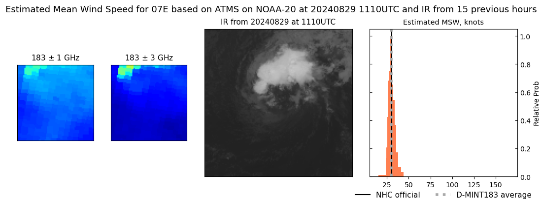 |
| 20240829 | 0352 UTC | SSMISF16 | 1007 hPa | 31 kts | 28 kts | 35 kts | 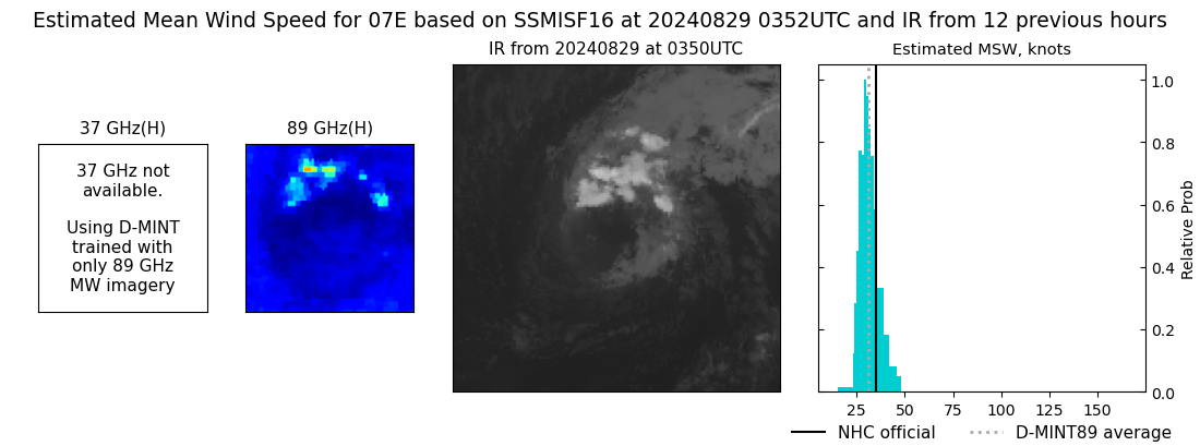 |
| 20240829 | 0140 UTC | SSMISF18 | 1006 hPa | 34 kts | 31 kts | 38 kts | 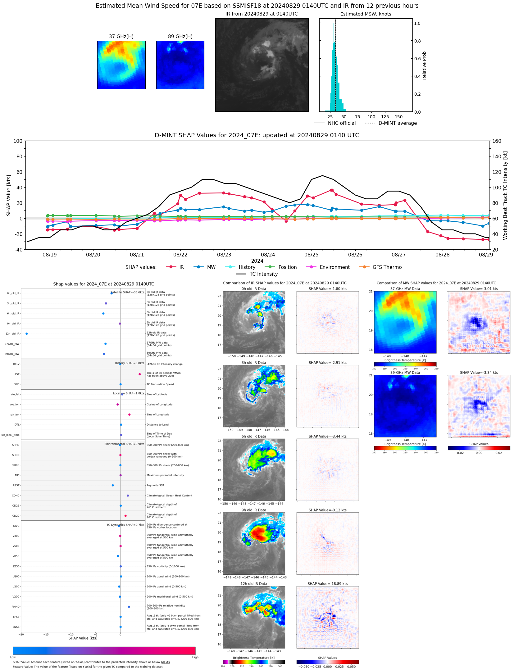 |
| 20240828 | 2239 UTC | ATMS-N20 | 1009 hPa | 29 kts | 27 kts | 32 kts | 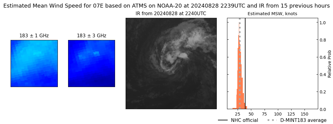 |
| 20240828 | 2208 UTC | GMI | 1009 hPa | 29 kts | 27 kts | 32 kts |  |
| 20240828 | 1200 UTC | TROPICS06 | 1006 hPa | 32 kts | 29 kts | 35 kts |  |
| 20240828 | 1200 UTC | TROPICS06 | 1006 hPa | 32 kts | 29 kts | 35 kts | 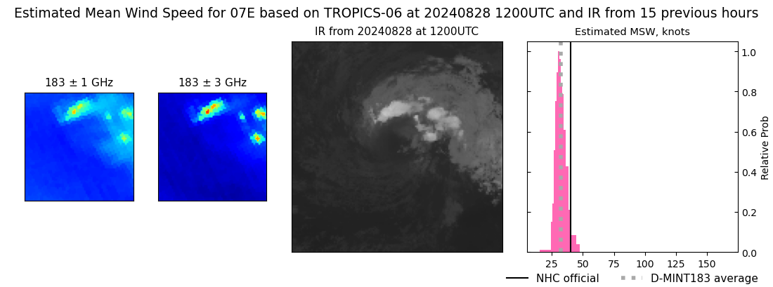 |
| 20240828 | 1128 UTC | ATMS-N20 | 1008 hPa | 33 kts | 30 kts | 36 kts | 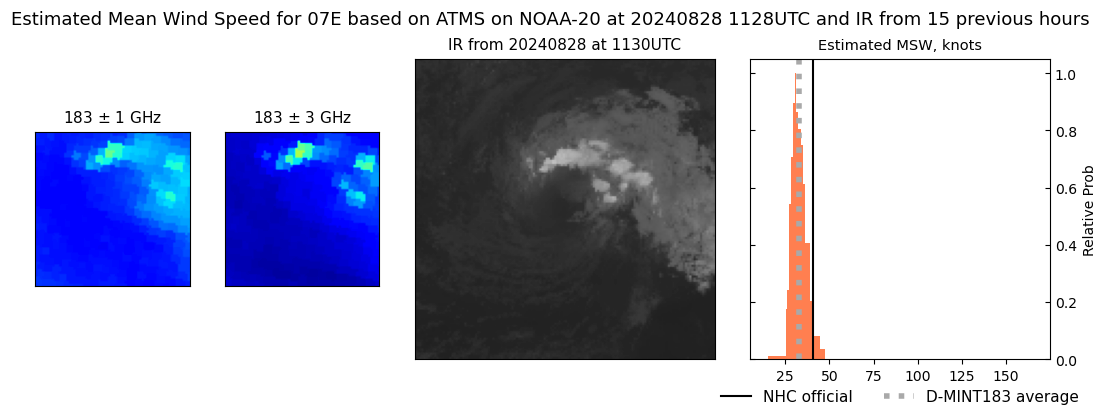 |
| 20240828 | 1117 UTC | AMSR2 | 1006 hPa | 34 kts | 31 kts | 38 kts | 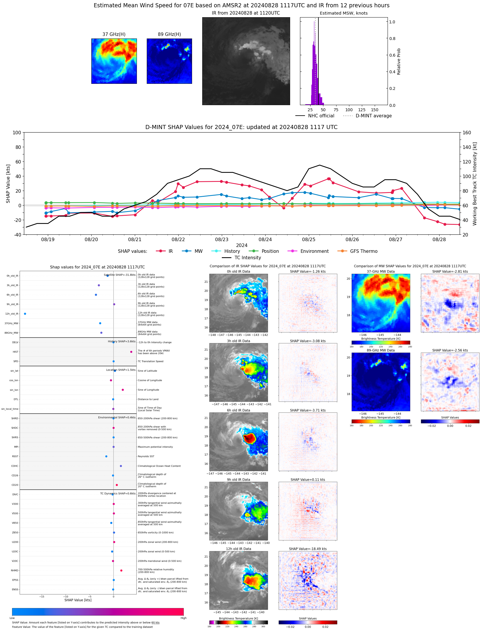 |
| 20240828 | 1104 UTC | ATMS-NPP | 1008 hPa | 32 kts | 29 kts | 35 kts | 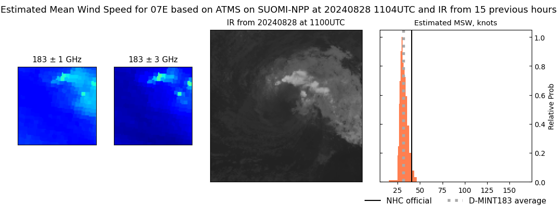 |
| 20240828 | 0302 UTC | SSMISF17 | 1004 hPa | 37 kts | 34 kts | 42 kts | 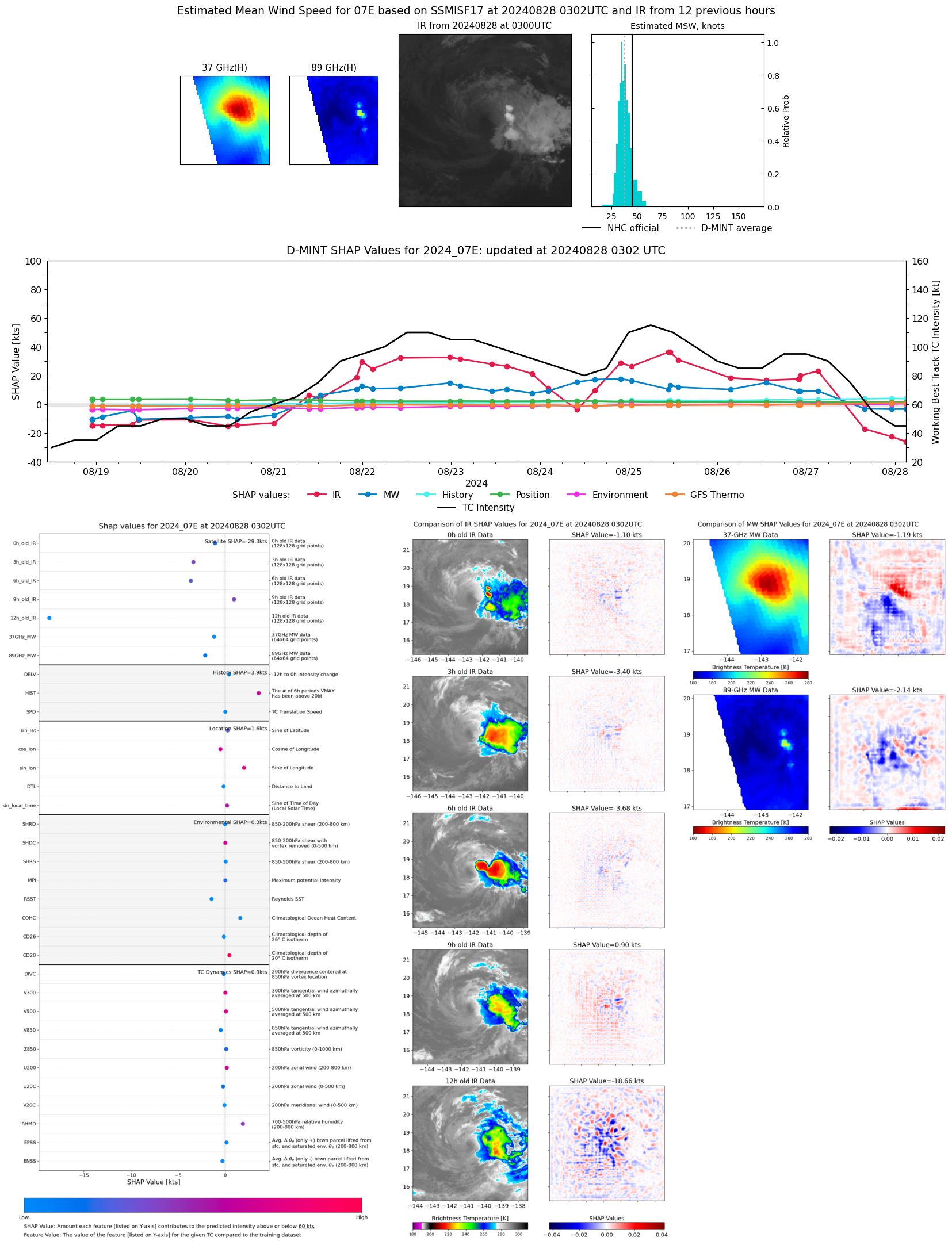 |
| 20240827 | 2305 UTC | AMSR2 | 1004 hPa | 41 kts | 37 kts | 45 kts | 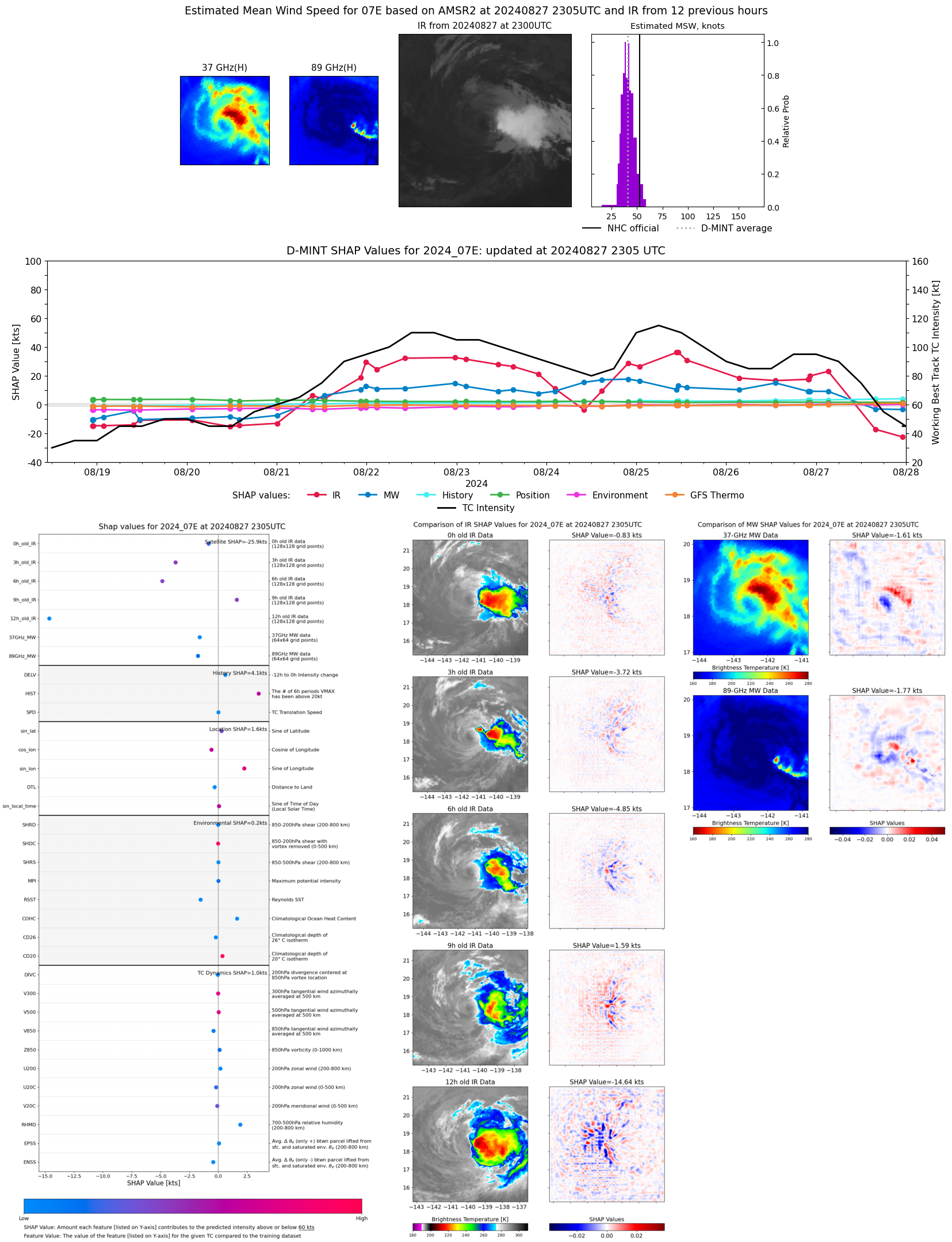 |
| 20240827 | 2258 UTC | ATMS-N20 | 1007 hPa | 36 kts | 33 kts | 40 kts | 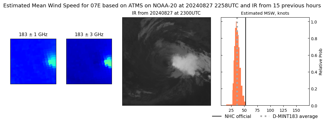 |
| 20240827 | 2234 UTC | ATMS-NPP | 1006 hPa | 37 kts | 34 kts | 41 kts |  |
| 20240827 | 2034 UTC | TROPICS05 | 1003 hPa | 37 kts | 33 kts | 42 kts | 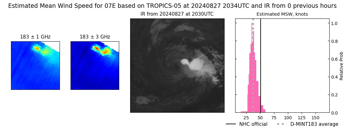 |
| 20240827 | 1549 UTC | SSMISF17 | 1000 hPa | 46 kts | 41 kts | 51 kts | 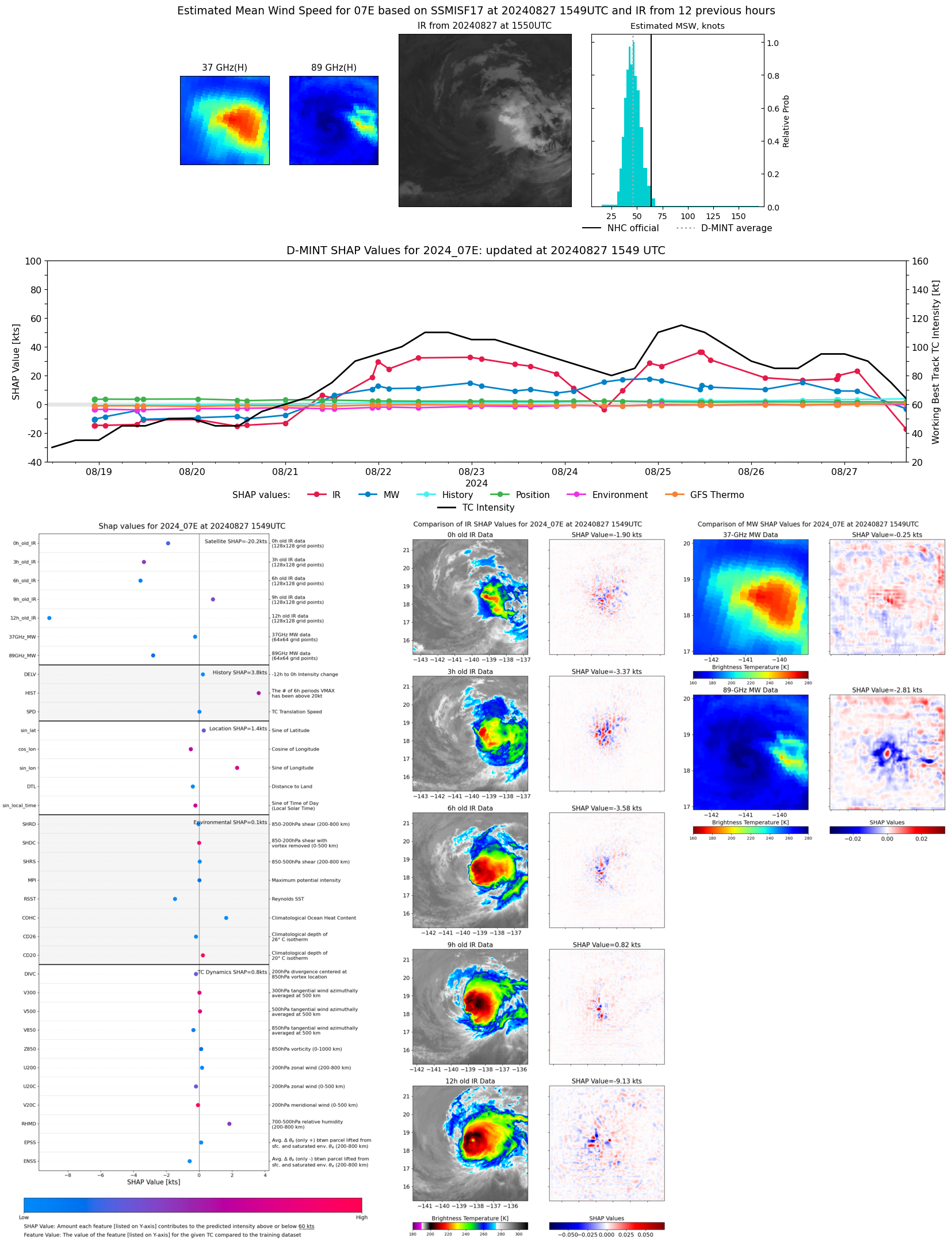 |
| 20240827 | 1512 UTC | SSMISF16 | 998 hPa | 49 kts | 44 kts | 54 kts | 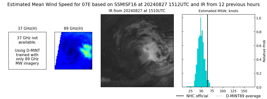 |
| 20240827 | 1259 UTC | SSMISF18 | 991 hPa | 72 kts | 65 kts | 78 kts | 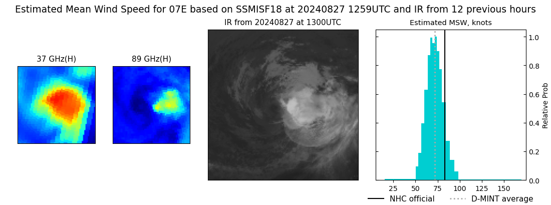 |
| 20240827 | 1226 UTC | TROPICS06 | 986 hPa | 69 kts | 64 kts | 73 kts | 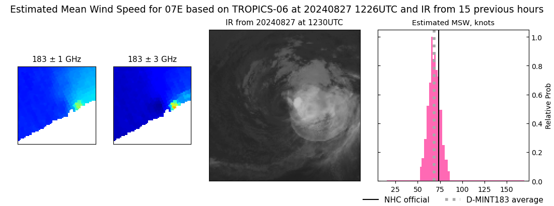 |
| 20240827 | 0315 UTC | SSMISF17 | 975 hPa | 97 kts | 92 kts | 103 kts | 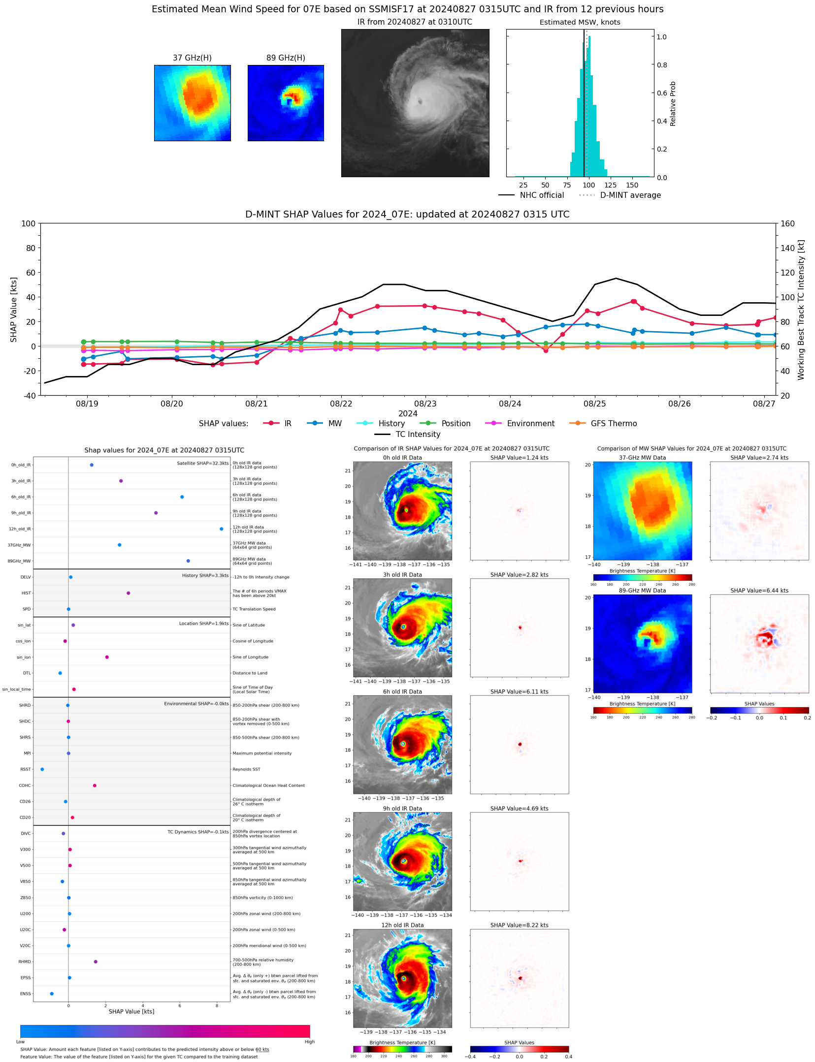 |
| 20240827 | 0238 UTC | SSMISF16 | 972 hPa | 93 kts | 87 kts | 99 kts | 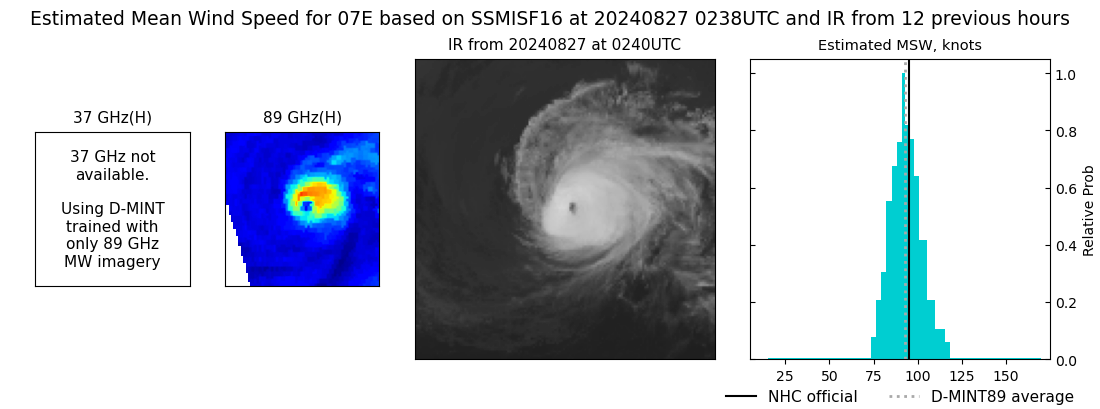 |
| 20240826 | 2253 UTC | ATMS-NPP | 975 hPa | 80 kts | 76 kts | 85 kts | 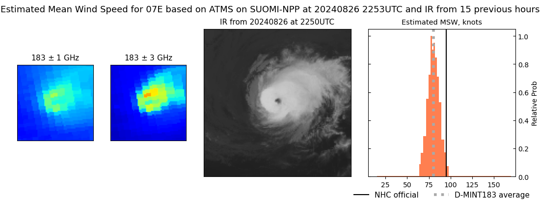 |
| 20240826 | 2227 UTC | ATMS-N21 | 971 hPa | 88 kts | 83 kts | 93 kts | 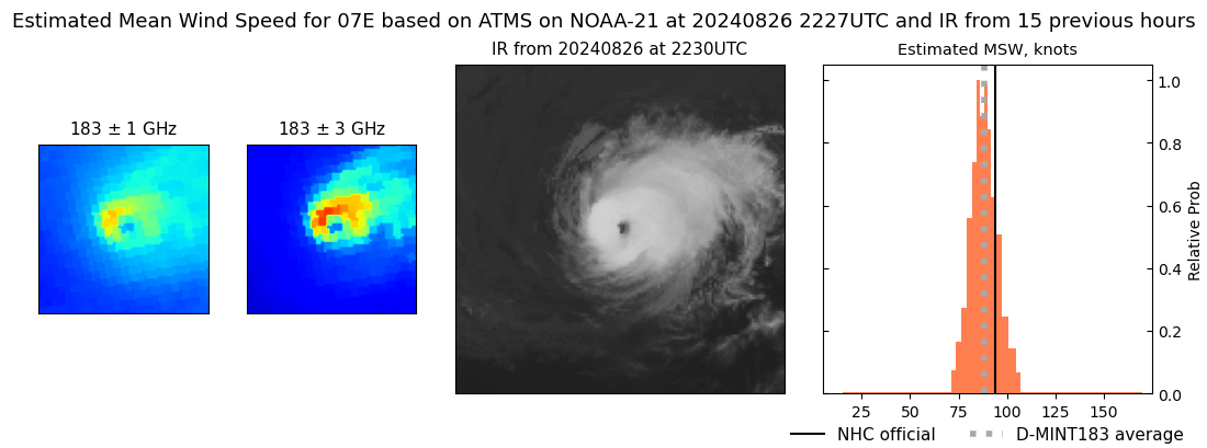 |
| 20240826 | 2222 UTC | AMSR2 | 974 hPa | 94 kts | 88 kts | 99 kts | 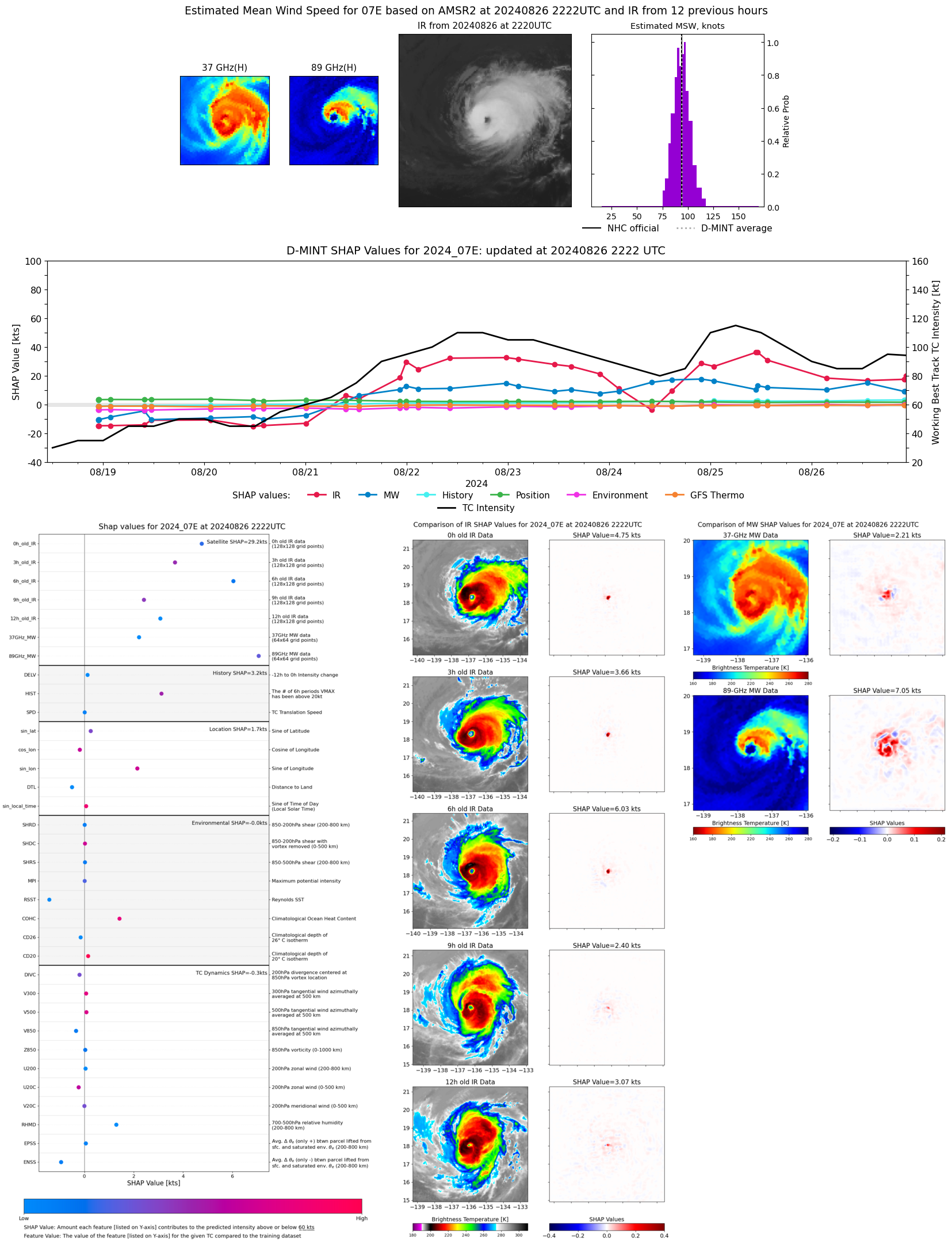 |
| 20240826 | 2204 UTC | GMI | 971 hPa | 91 kts | 86 kts | 97 kts | 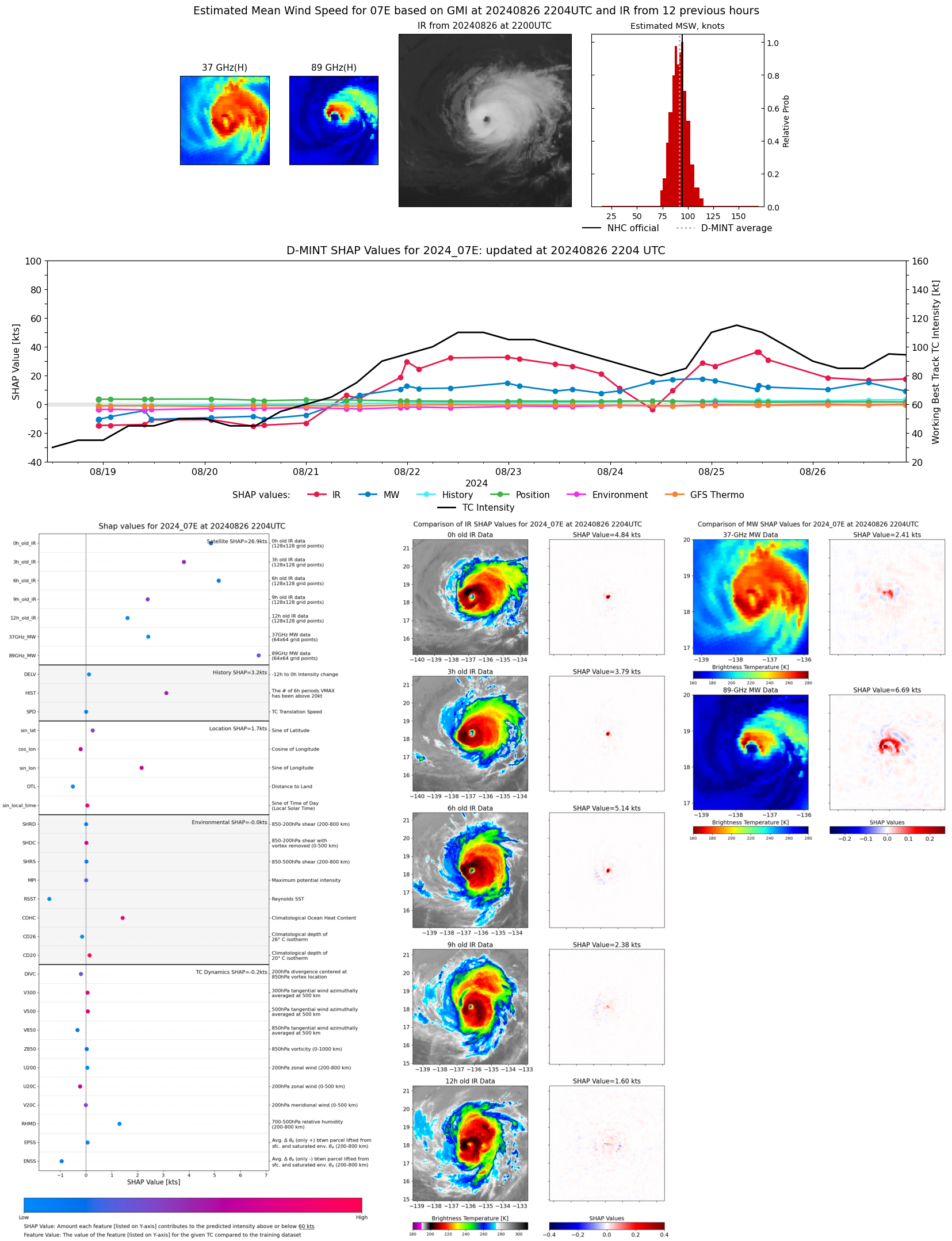 |
| 20240826 | 2158 UTC | GMI | 971 hPa | 91 kts | 86 kts | 97 kts |  |
| 20240826 | 1524 UTC | SSMISF16 | 975 hPa | 88 kts | 82 kts | 94 kts | 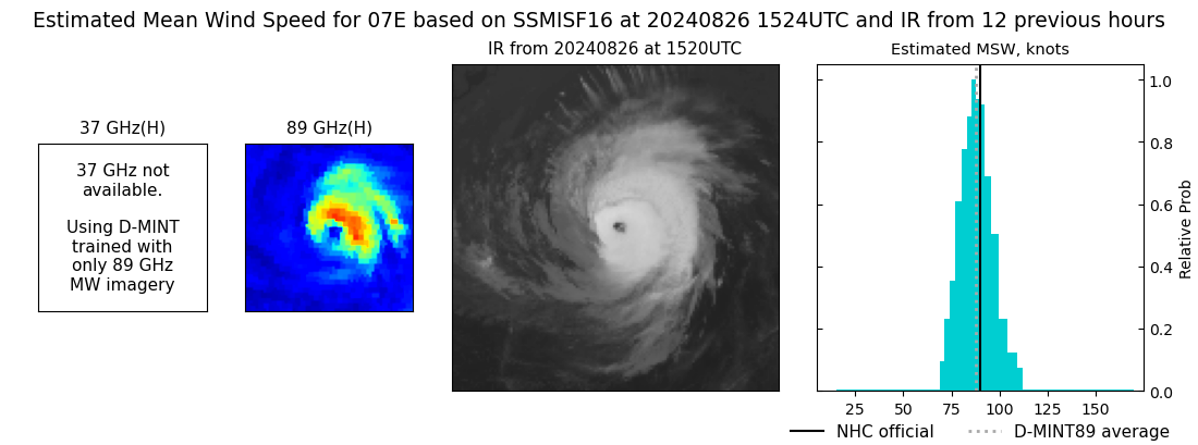 |
| 20240826 | 1312 UTC | SSMISF18 | 976 hPa | 96 kts | 89 kts | 102 kts | 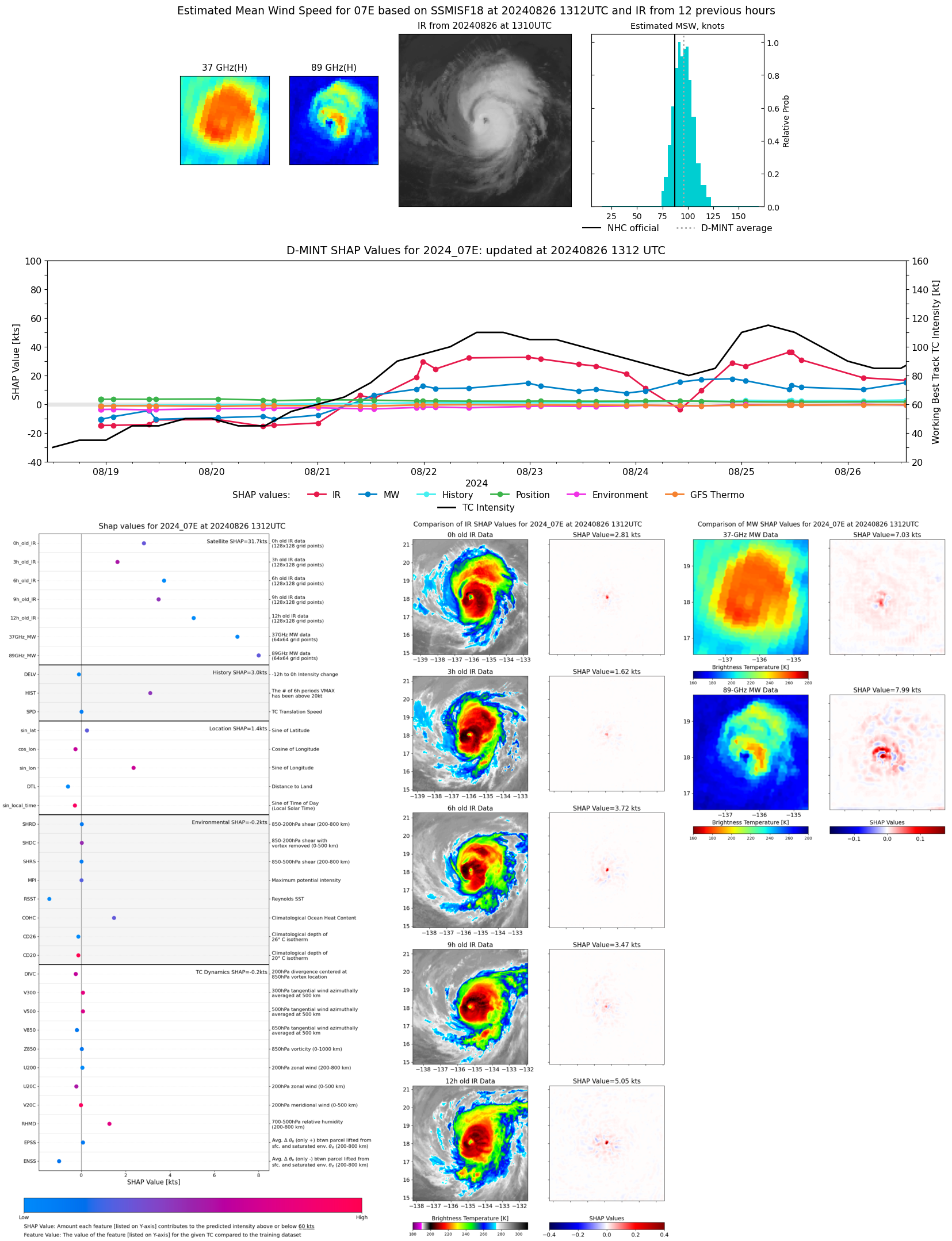 |
| 20240826 | 1236 UTC | TROPICS05 | 977 hPa | 84 kts | 79 kts | 88 kts | 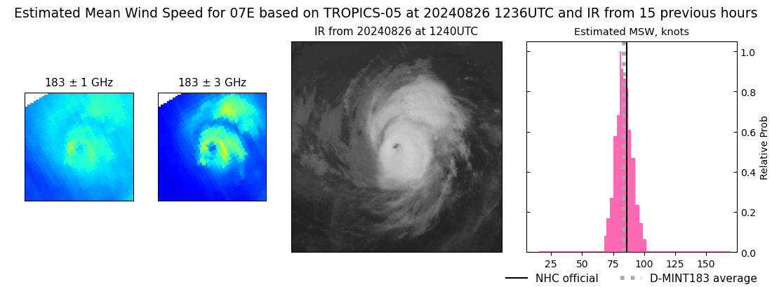 |
| 20240826 | 1026 UTC | ATMS-N20 | 980 hPa | 75 kts | 70 kts | 80 kts | 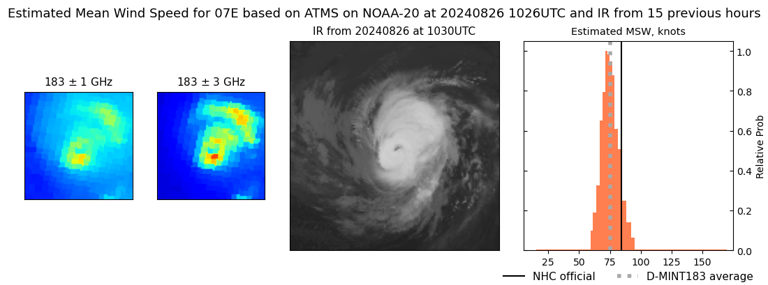 |
| 20240826 | 0758 UTC | TROPICS03 | 977 hPa | 79 kts | 74 kts | 84 kts | 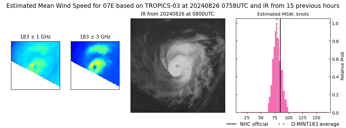 |
| 20240826 | 0330 UTC | SSMISF17 | 981 hPa | 93 kts | 86 kts | 100 kts | 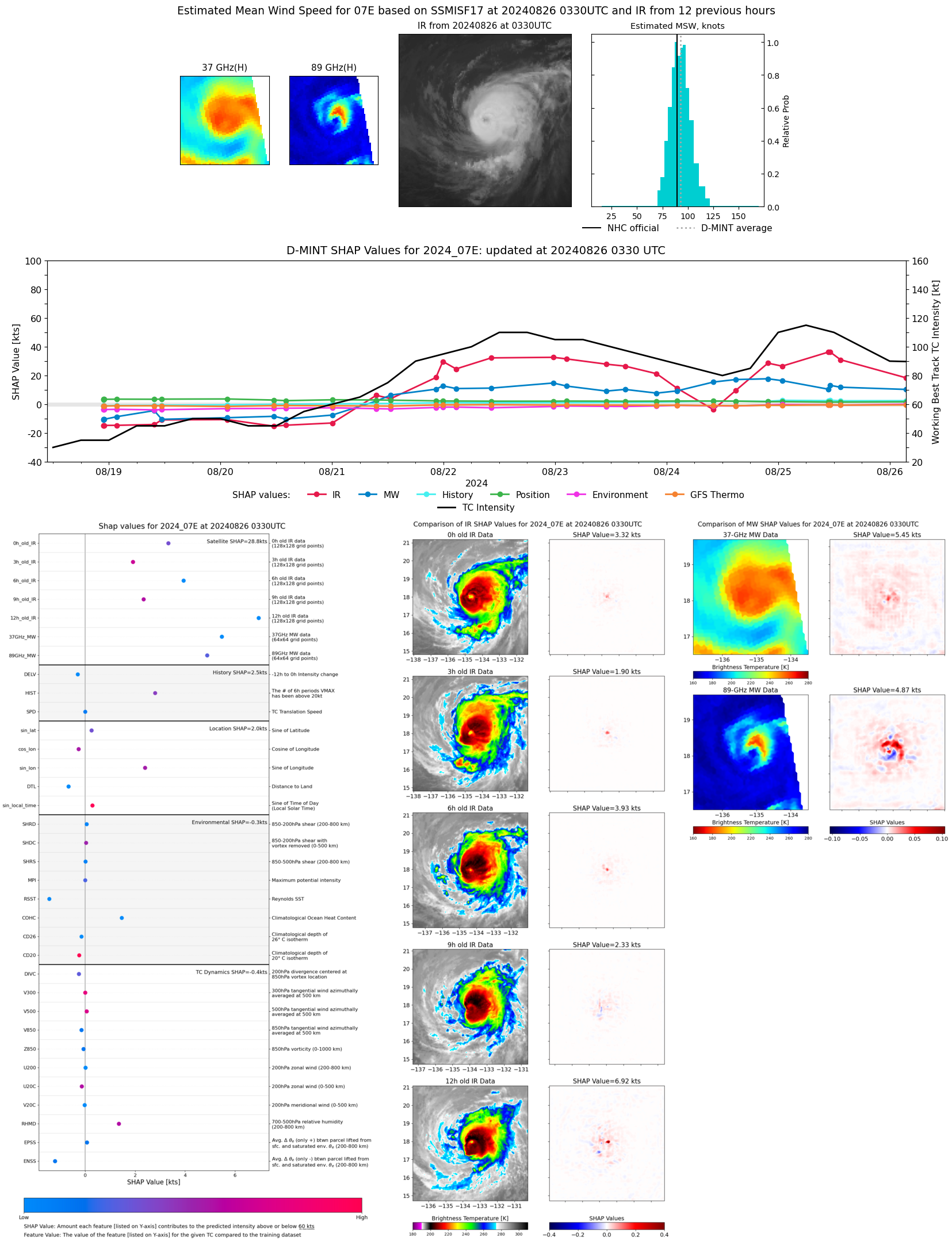 |
| 20240826 | 0250 UTC | SSMISF16 | 982 hPa | 84 kts | 77 kts | 90 kts | 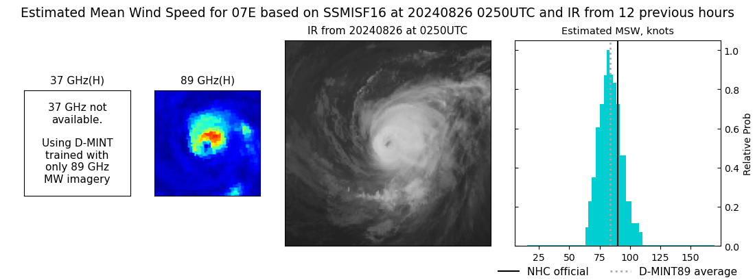 |
| 20240826 | 0038 UTC | SSMISF18 | 981 hPa | 95 kts | 88 kts | 102 kts | 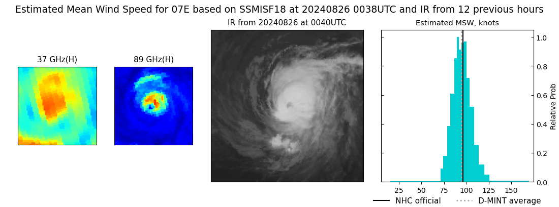 |
| 20240825 | 2246 UTC | ATMS-N21 | 982 hPa | 72 kts | 68 kts | 77 kts | 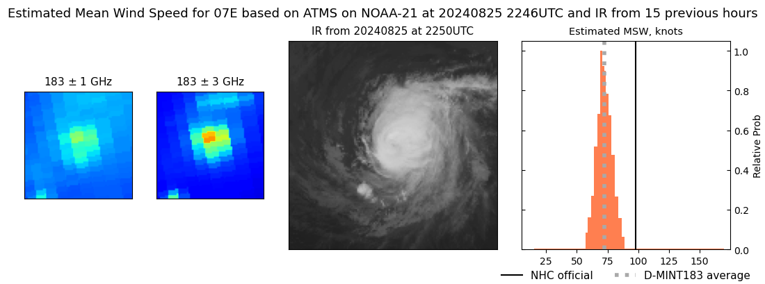 |
| 20240825 | 2154 UTC | ATMS-N20 | 976 hPa | 81 kts | 77 kts | 85 kts | 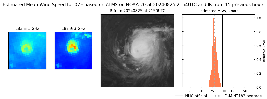 |
| 20240825 | 1538 UTC | SSMISF16 | 971 hPa | 104 kts | 97 kts | 110 kts | 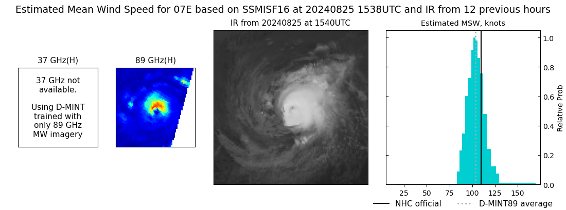 |
| 20240825 | 1326 UTC | SSMISF18 | 961 hPa | 106 kts | 99 kts | 112 kts | 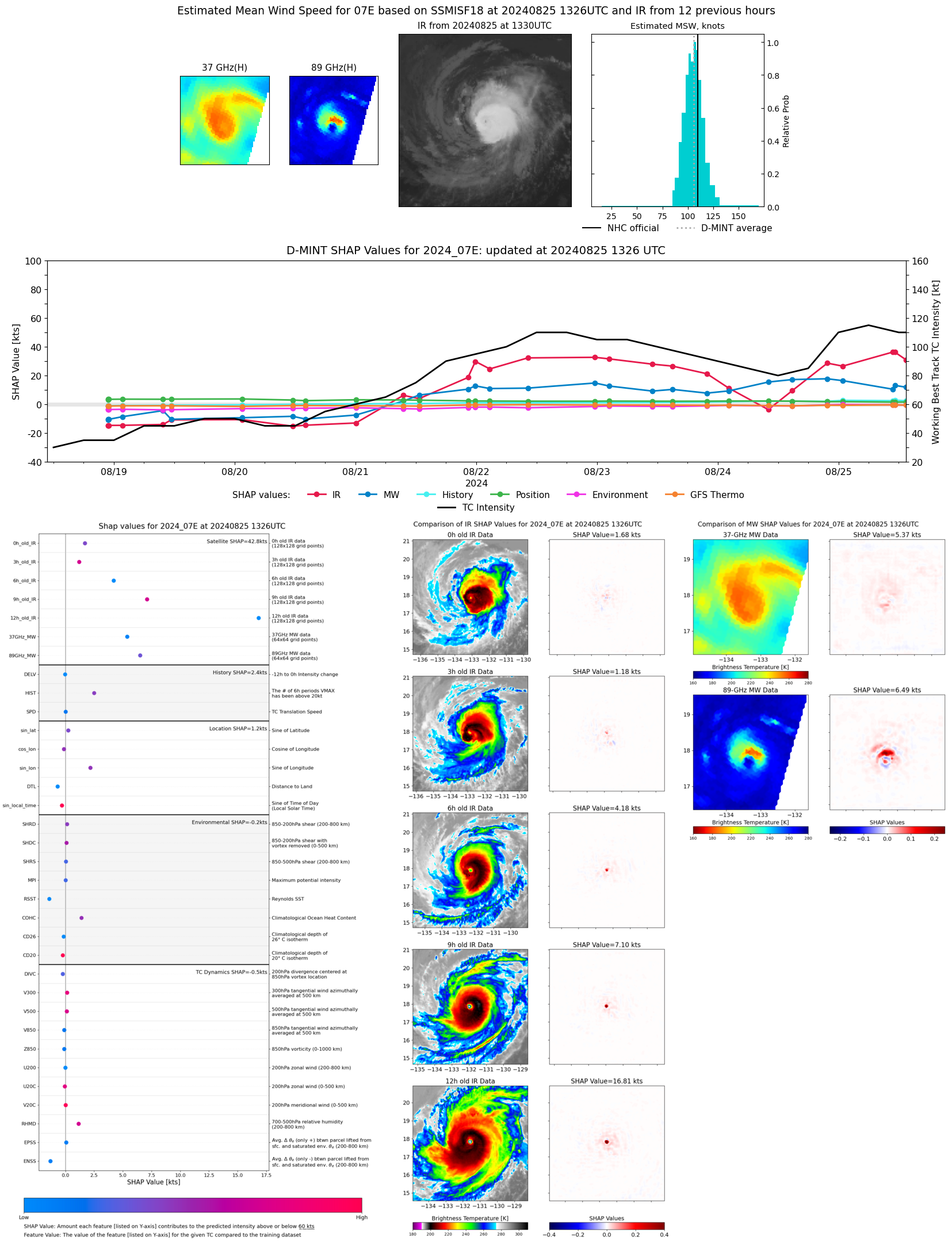 |
| 20240825 | 1259 UTC | TROPICS05 | 965 hPa | 91 kts | 86 kts | 96 kts | 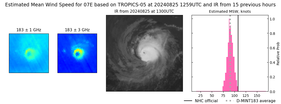 |
| 20240825 | 1113 UTC | GMI | 961 hPa | 113 kts | 107 kts | 119 kts | 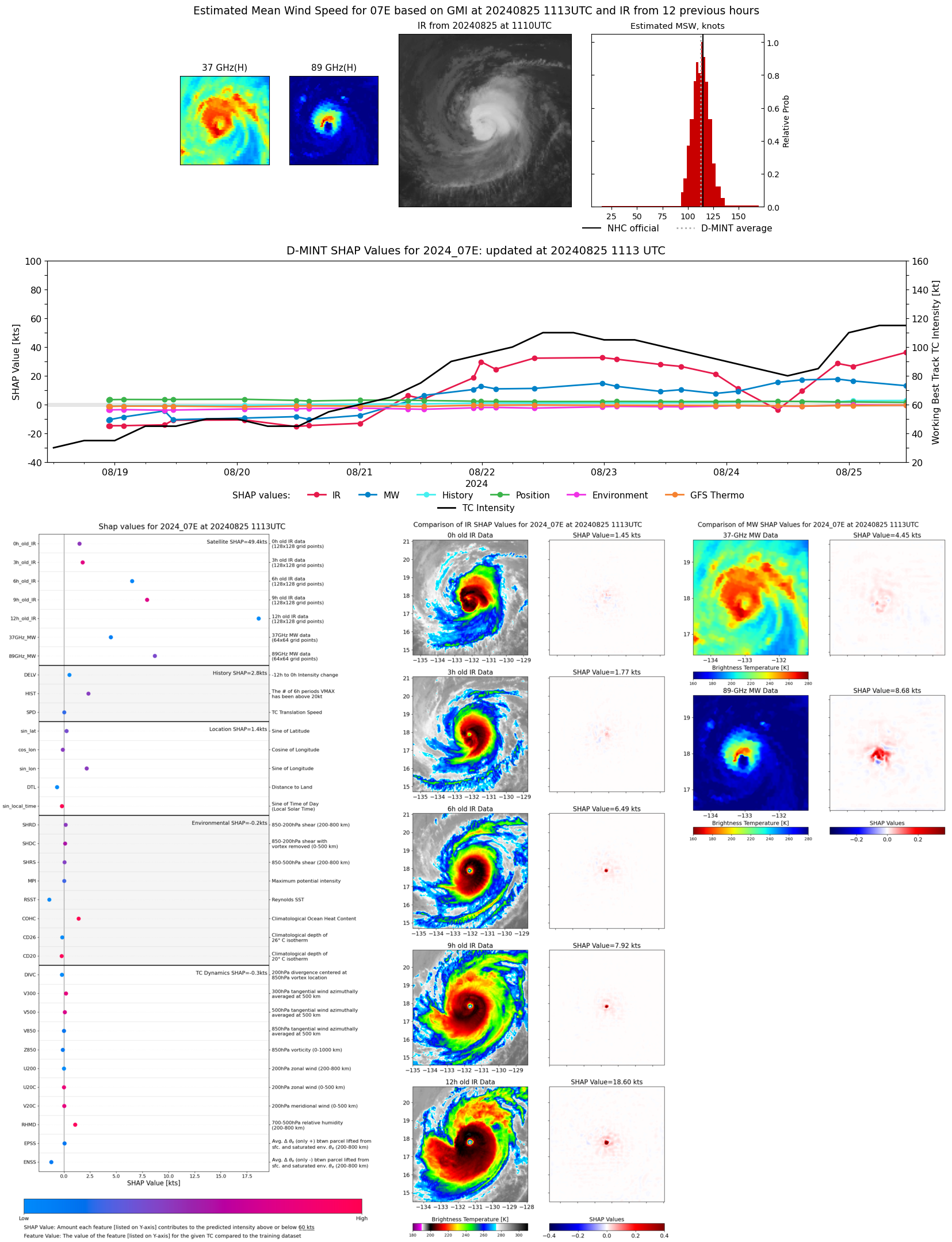 |
| 20240825 | 1046 UTC | AMSR2 | 960 hPa | 110 kts | 104 kts | 115 kts | 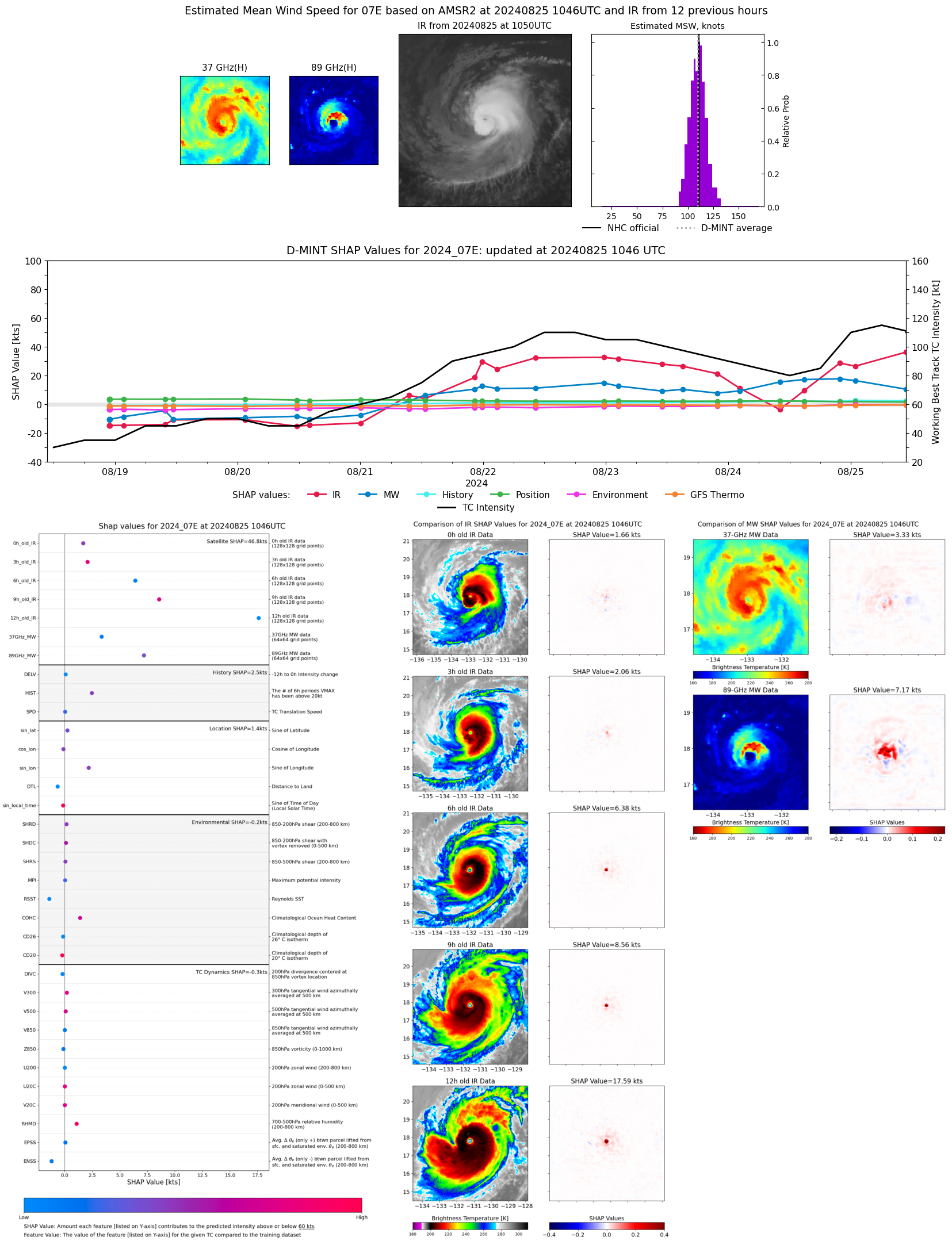 |
| 20240825 | 1044 UTC | ATMS-N20 | 960 hPa | 108 kts | 103 kts | 113 kts | 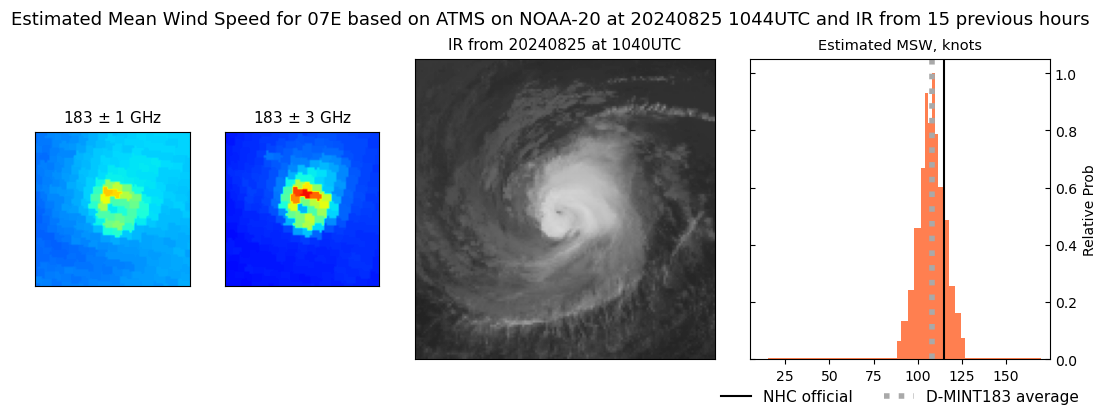 |
| 20240825 | 1020 UTC | ATMS-NPP | 960 hPa | 105 kts | 101 kts | 110 kts | 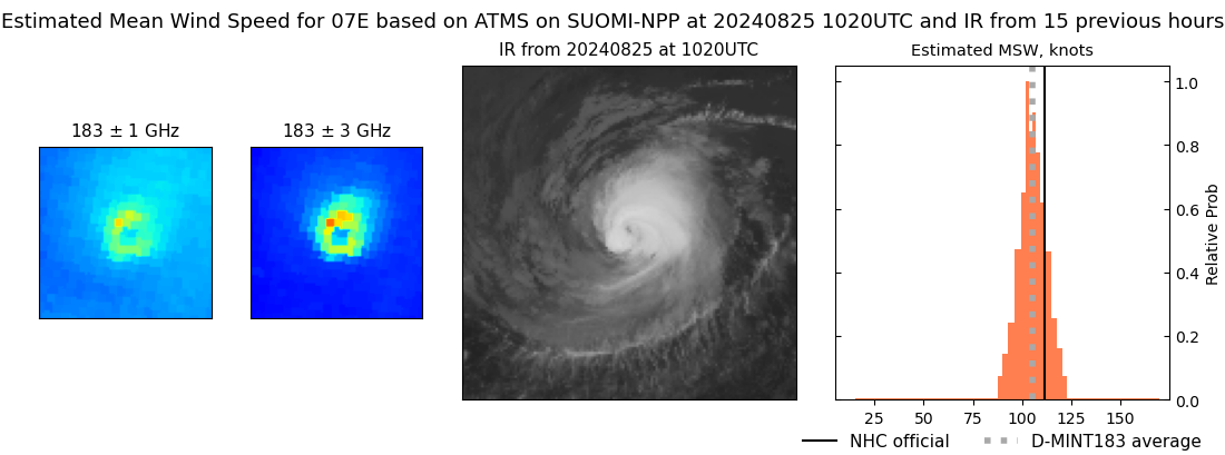 |
| 20240825 | 0955 UTC | ATMS-N21 | 965 hPa | 98 kts | 92 kts | 103 kts | 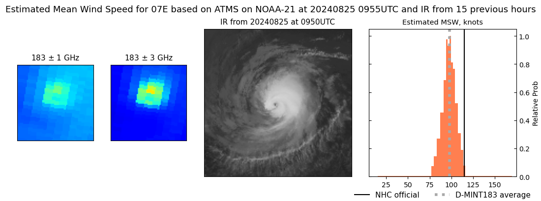 |
| 20240825 | 0821 UTC | TROPICS03 | 961 hPa | 106 kts | 102 kts | 111 kts | 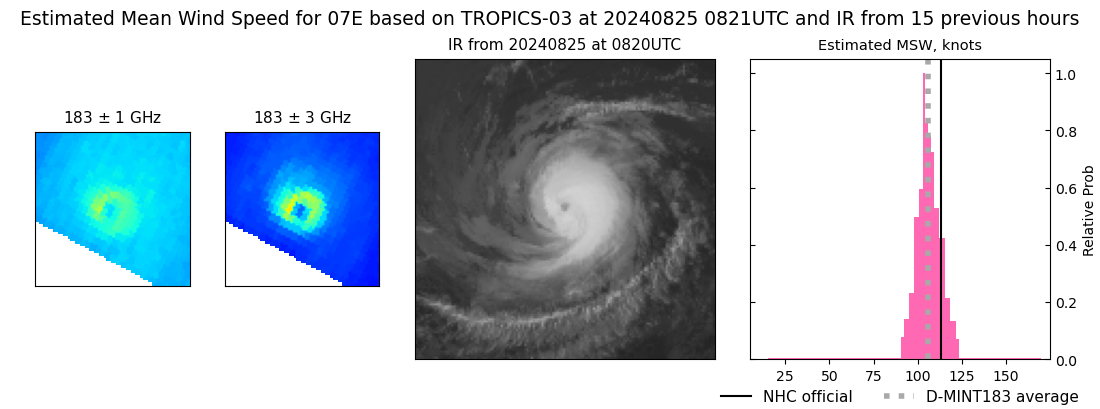 |
| 20240825 | 0304 UTC | SSMISF16 | 958 hPa | 116 kts | 110 kts | 122 kts | 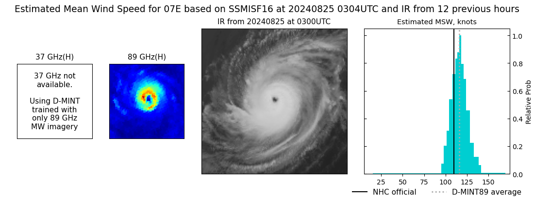 |
| 20240825 | 0052 UTC | SSMISF18 | 960 hPa | 107 kts | 100 kts | 113 kts |  |
| 20240824 | 2213 UTC | ATMS-N20 | 958 hPa | 104 kts | 99 kts | 109 kts | 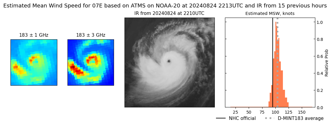 |
| 20240824 | 2149 UTC | ATMS-NPP | 959 hPa | 103 kts | 98 kts | 108 kts |  |
| 20240824 | 2148 UTC | GMI | 960 hPa | 109 kts | 103 kts | 115 kts | 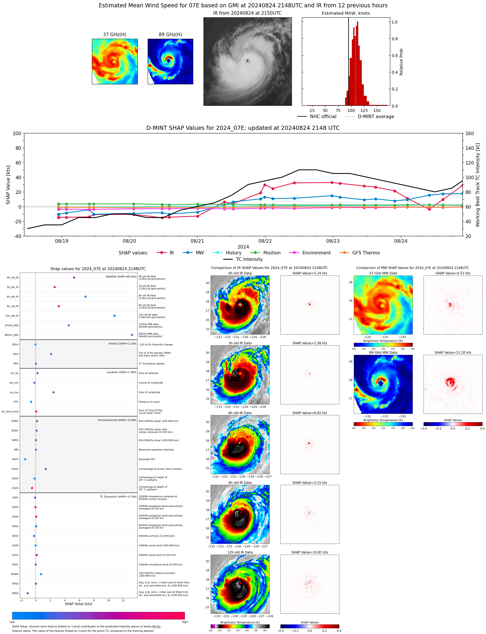 |
| 20240824 | 2124 UTC | ATMS-N21 | 967 hPa | 94 kts | 89 kts | 100 kts | 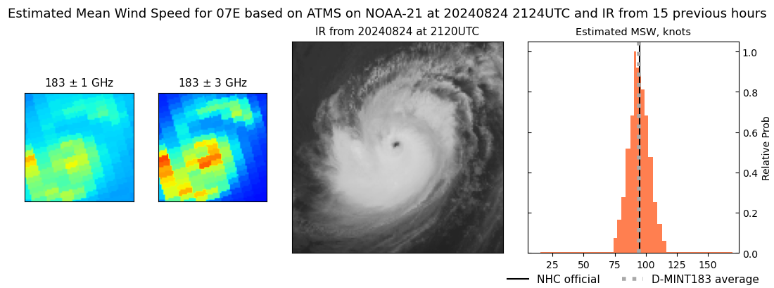 |
| 20240824 | 1449 UTC | SSMISF17 | 973 hPa | 89 kts | 82 kts | 96 kts | 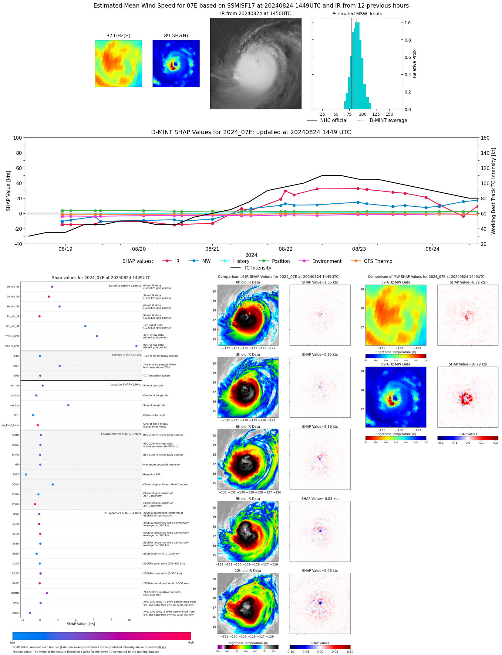 |
| 20240824 | 1323 UTC | TROPICS05 | 982 hPa | 78 kts | 72 kts | 84 kts | 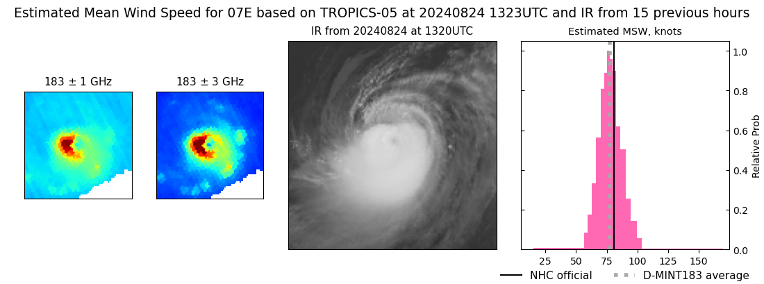 |
| 20240824 | 1039 UTC | ATMS-NPP | 982 hPa | 78 kts | 72 kts | 84 kts | 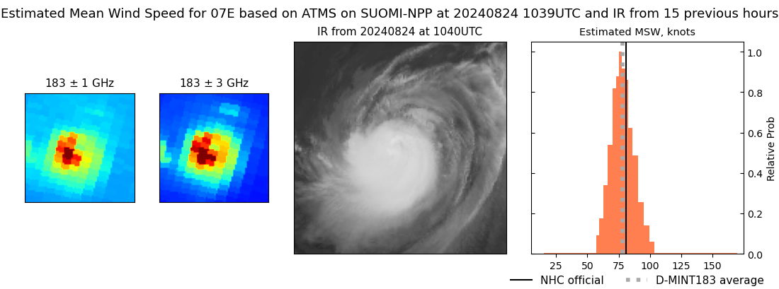 |
| 20240824 | 1013 UTC | ATMS-N21 | 983 hPa | 72 kts | 66 kts | 78 kts | 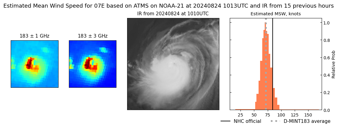 |
| 20240824 | 1004 UTC | AMSR2 | 982 hPa | 74 kts | 68 kts | 81 kts | 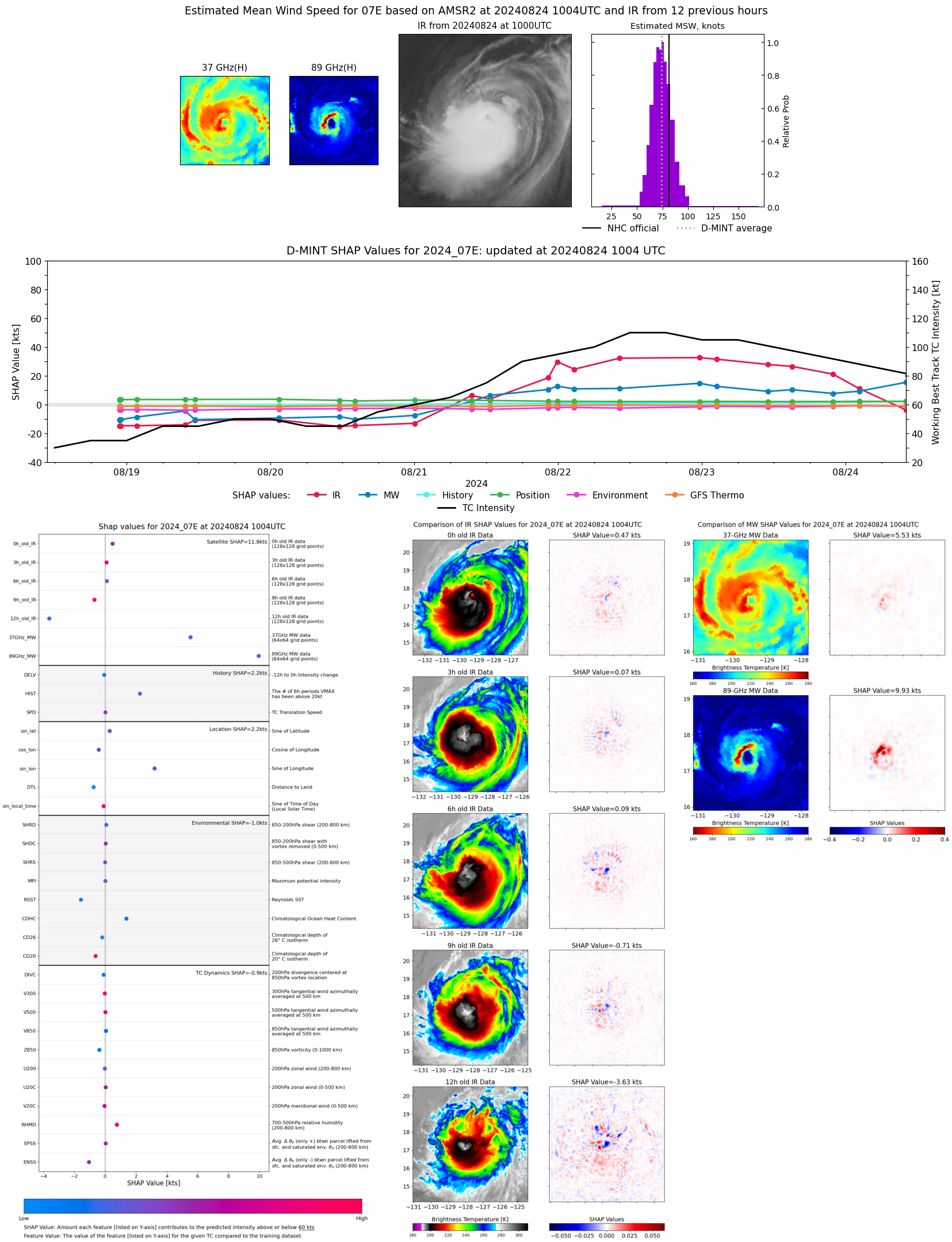 |
| 20240824 | 0844 UTC | TROPICS03 | 983 hPa | 75 kts | 69 kts | 81 kts | 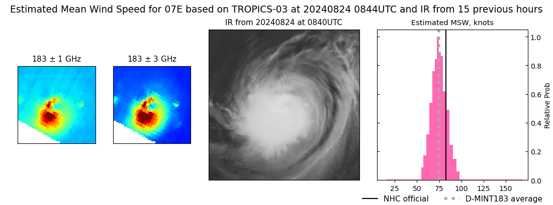 |
| 20240824 | 0215 UTC | SSMISF17 | 981 hPa | 83 kts | 77 kts | 90 kts | 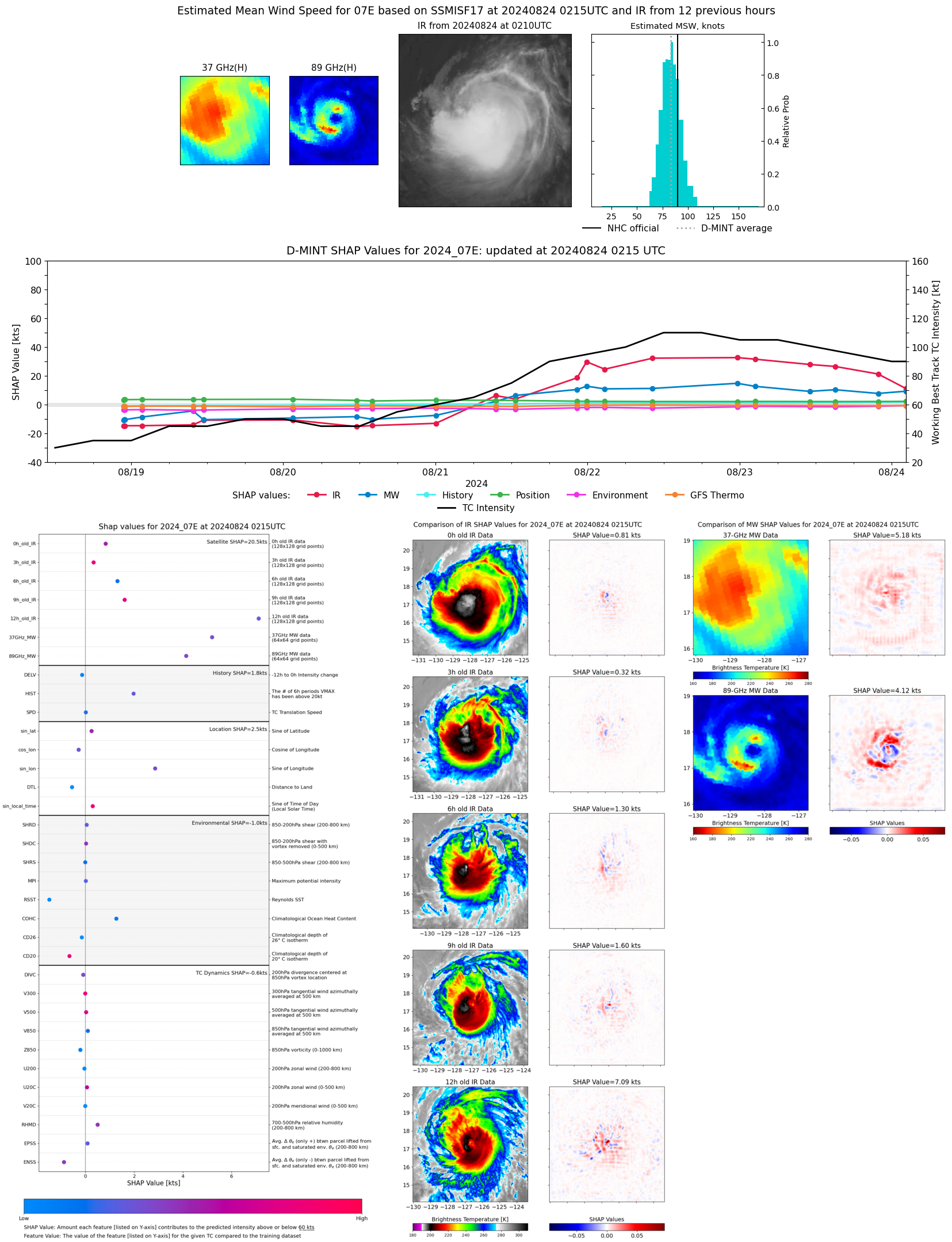 |
| 20240823 | 2208 UTC | ATMS-NPP | 970 hPa | 90 kts | 85 kts | 96 kts | 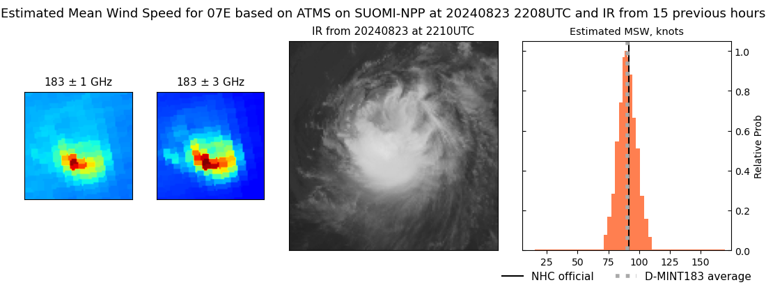 |
| 20240823 | 2151 UTC | AMSR2 | 974 hPa | 91 kts | 84 kts | 98 kts | 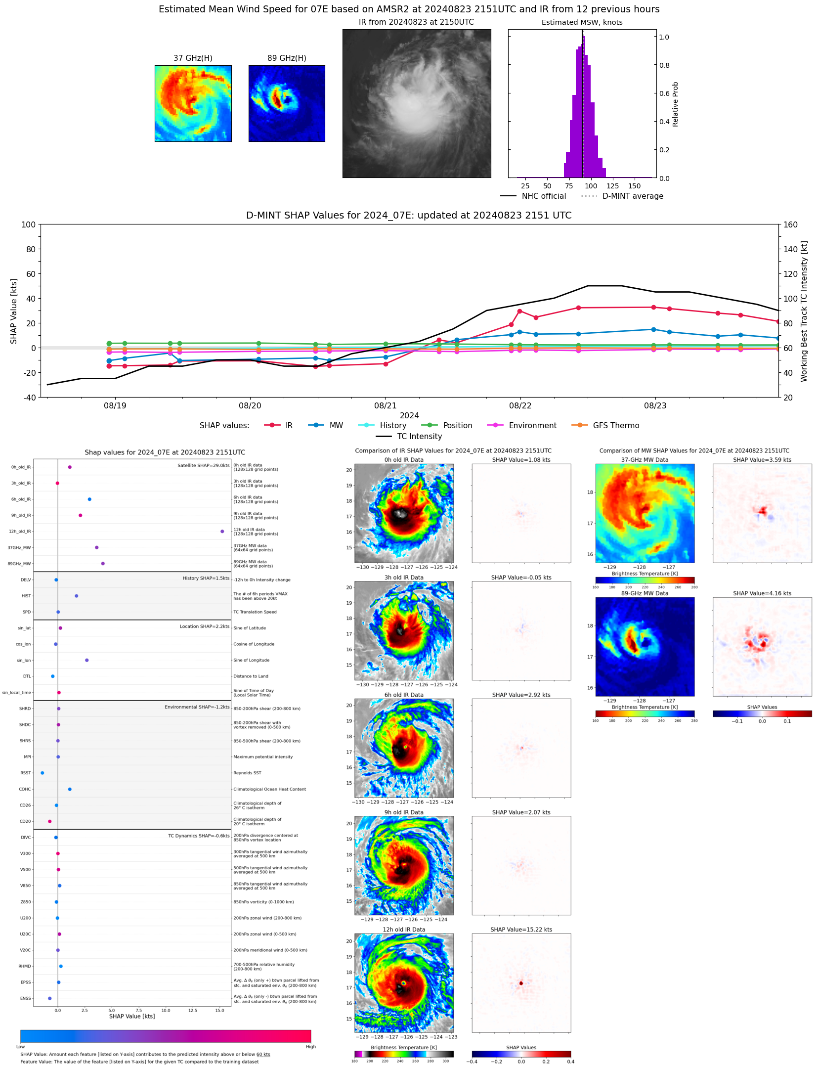 |
| 20240823 | 2143 UTC | ATMS-N21 | 967 hPa | 86 kts | 81 kts | 91 kts | 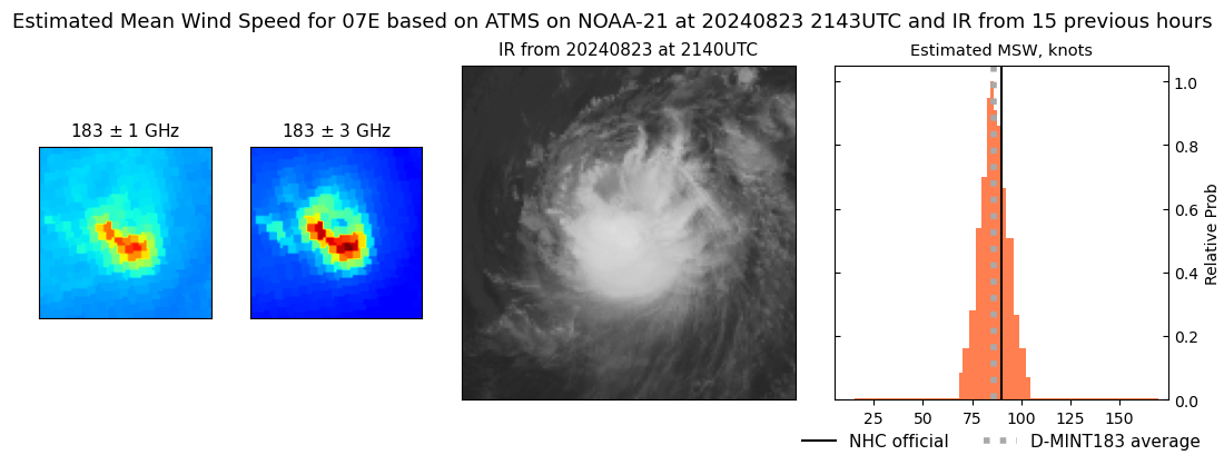 |
| 20240823 | 1503 UTC | SSMISF17 | 964 hPa | 98 kts | 92 kts | 104 kts | 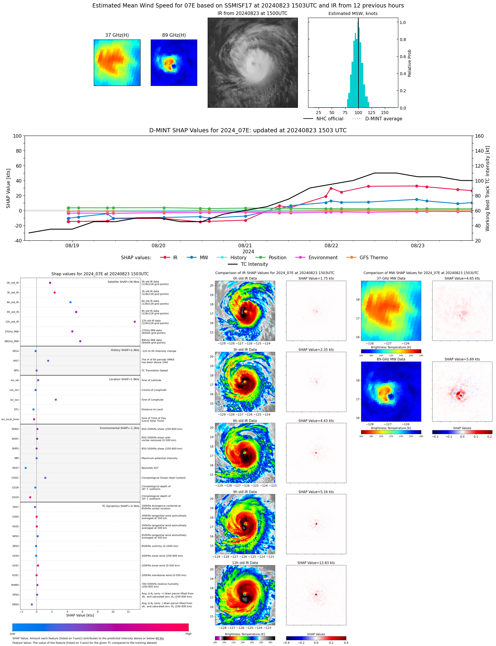 |
| 20240823 | 1424 UTC | SSMISF16 | 965 hPa | 96 kts | 90 kts | 103 kts | 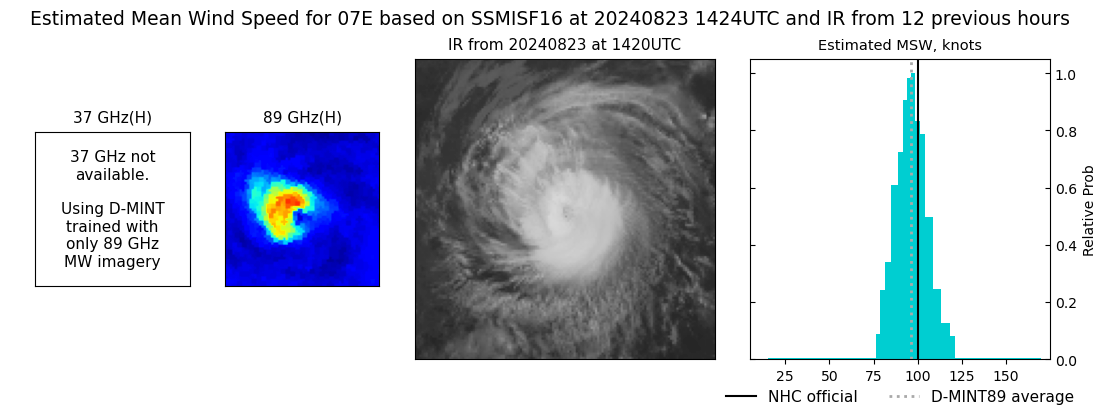 |
| 20240823 | 1346 UTC | TROPICS05 | 963 hPa | 96 kts | 91 kts | 102 kts |  |
| 20240823 | 1212 UTC | SSMISF18 | 962 hPa | 98 kts | 92 kts | 104 kts | 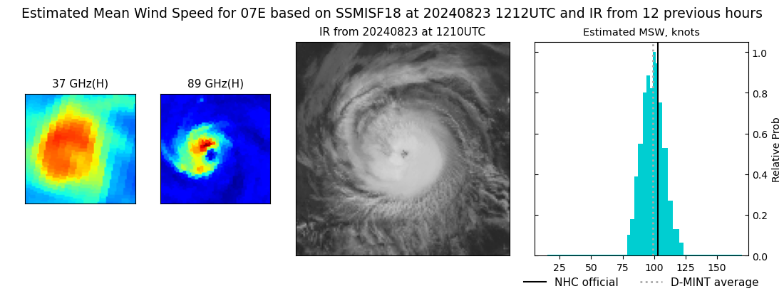 |
| 20240823 | 1103 UTC | GMI | 965 hPa | 98 kts | 92 kts | 104 kts | 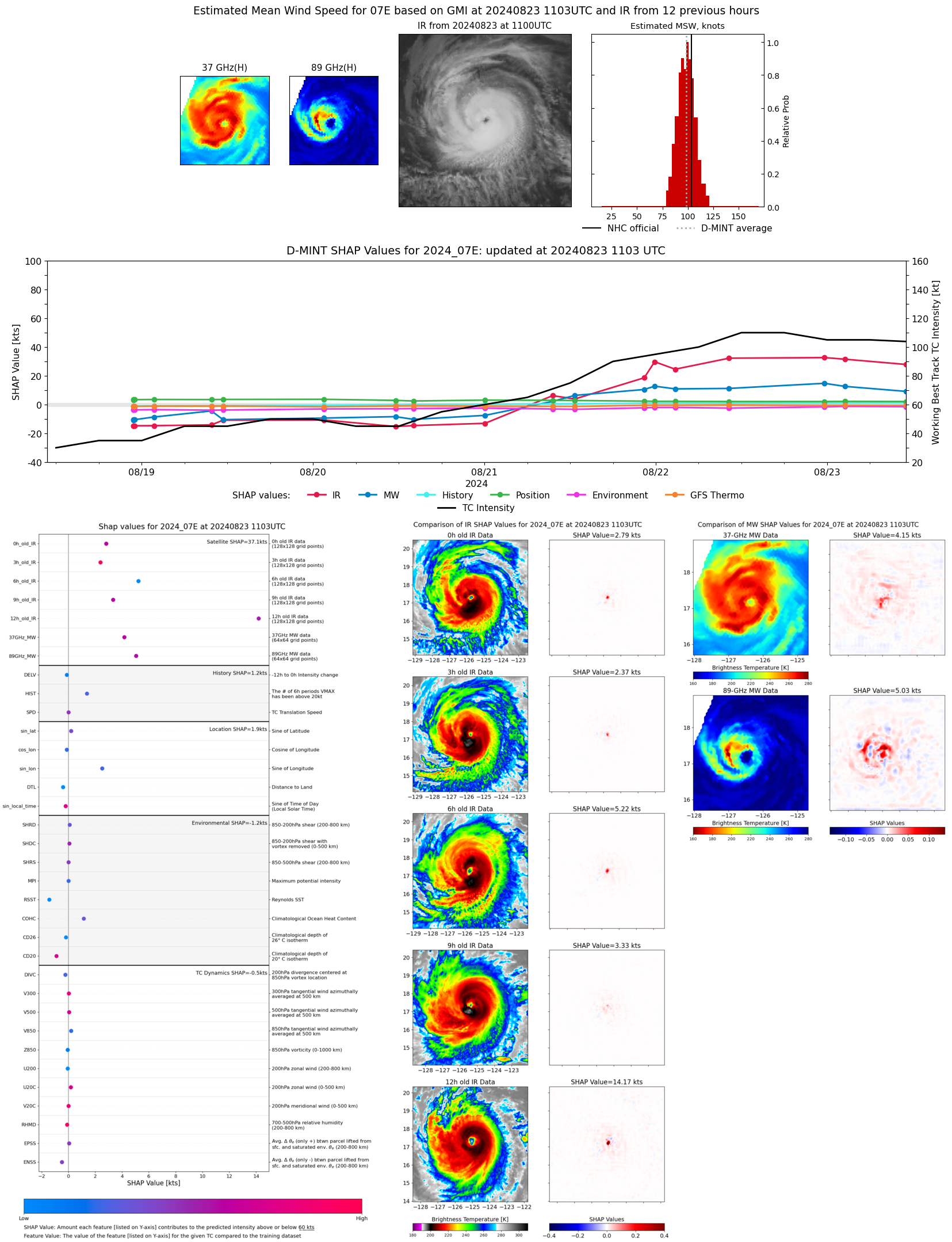 |
| 20240823 | 1033 UTC | ATMS-N21 | 962 hPa | 98 kts | 93 kts | 104 kts | 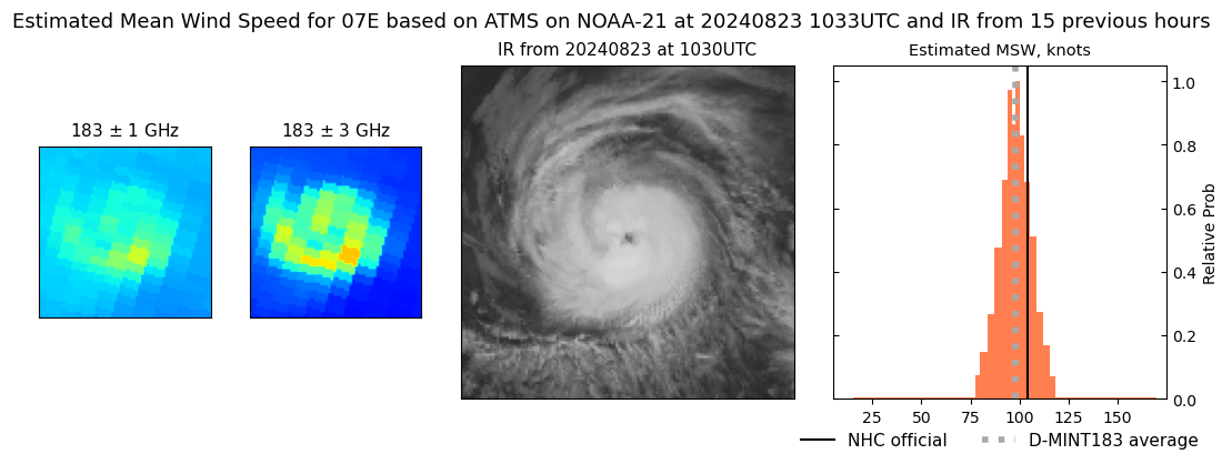 |
| 20240823 | 0942 UTC | ATMS-N20 | 960 hPa | 104 kts | 99 kts | 109 kts | 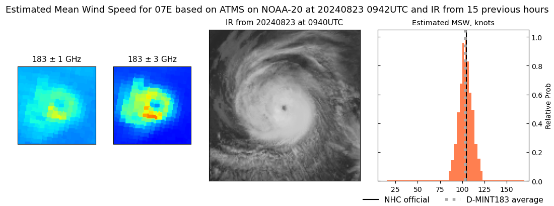 |
| 20240823 | 0907 UTC | TROPICS03 | 961 hPa | 103 kts | 98 kts | 108 kts | 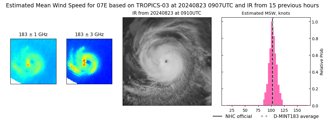 |
| 20240823 | 0229 UTC | SSMISF17 | 959 hPa | 106 kts | 99 kts | 112 kts | 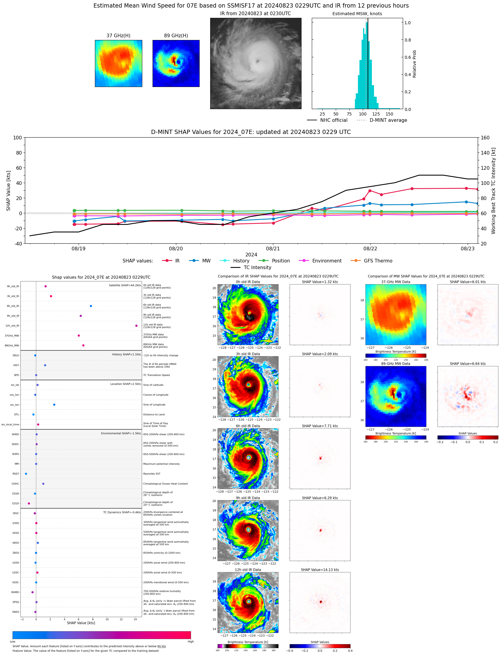 |
| 20240823 | 0150 UTC | SSMISF16 | 962 hPa | 109 kts | 103 kts | 115 kts | 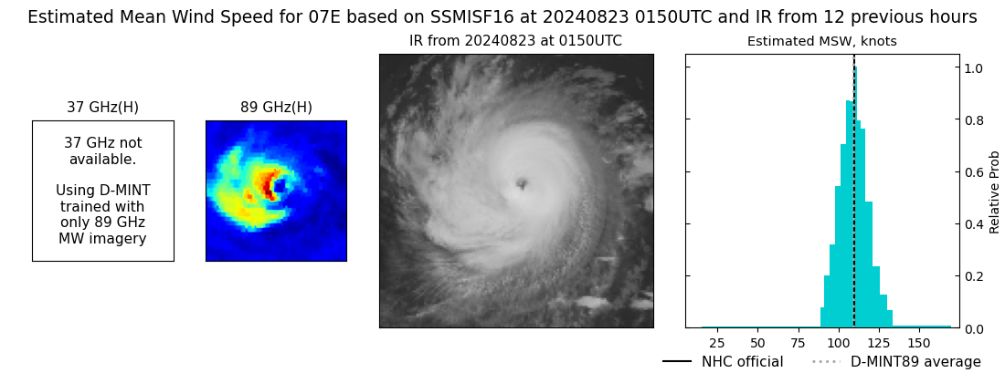 |
| 20240822 | 2338 UTC | SSMISF18 | 958 hPa | 105 kts | 99 kts | 111 kts | 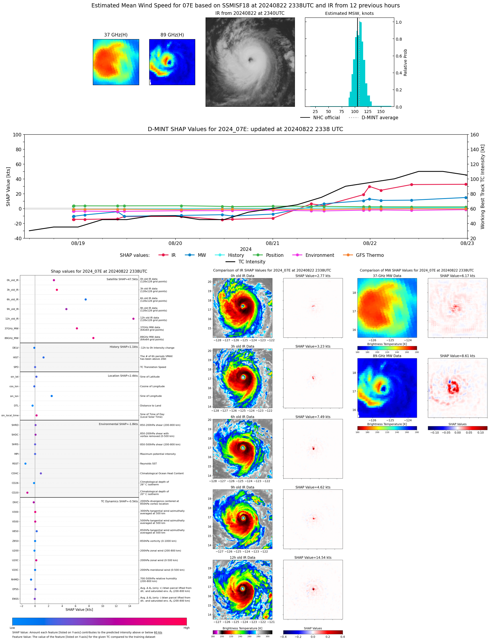 |
| 20240822 | 2201 UTC | ATMS-N21 | 963 hPa | 105 kts | 100 kts | 110 kts | 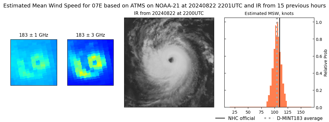 |
| 20240822 | 2110 UTC | ATMS-N20 | 965 hPa | 104 kts | 99 kts | 110 kts | 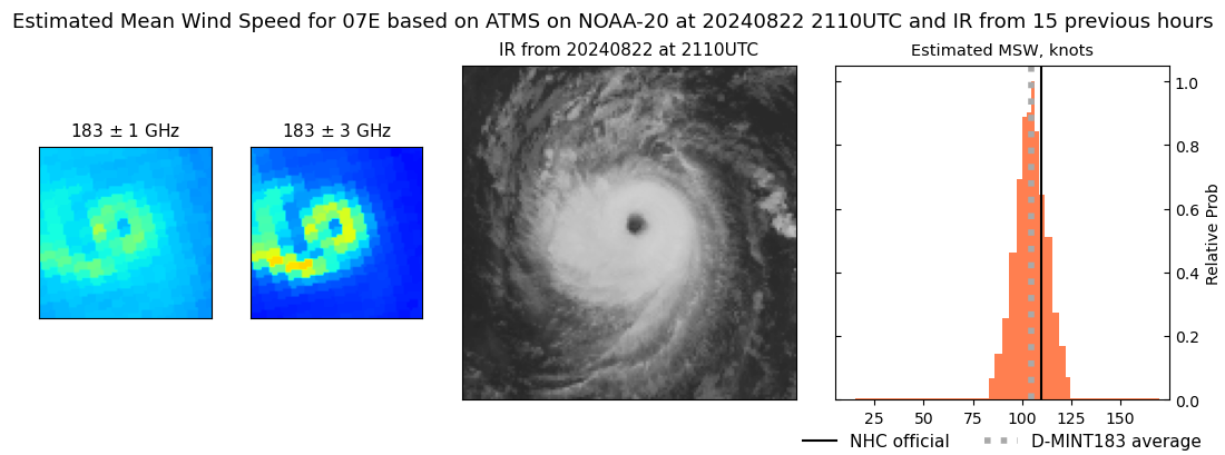 |
| 20240822 | 1437 UTC | SSMISF16 | 960 hPa | 105 kts | 99 kts | 111 kts | 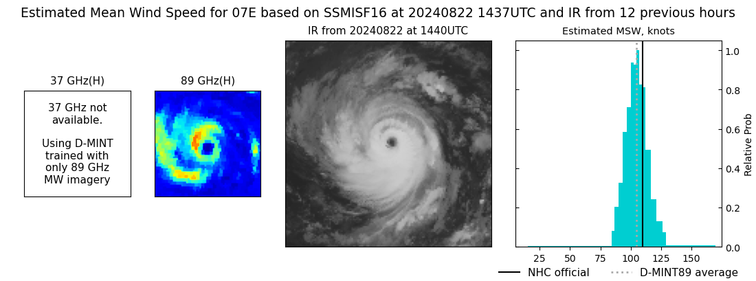 |
| 20240822 | 1226 UTC | SSMISF18 | 962 hPa | 99 kts | 94 kts | 104 kts | 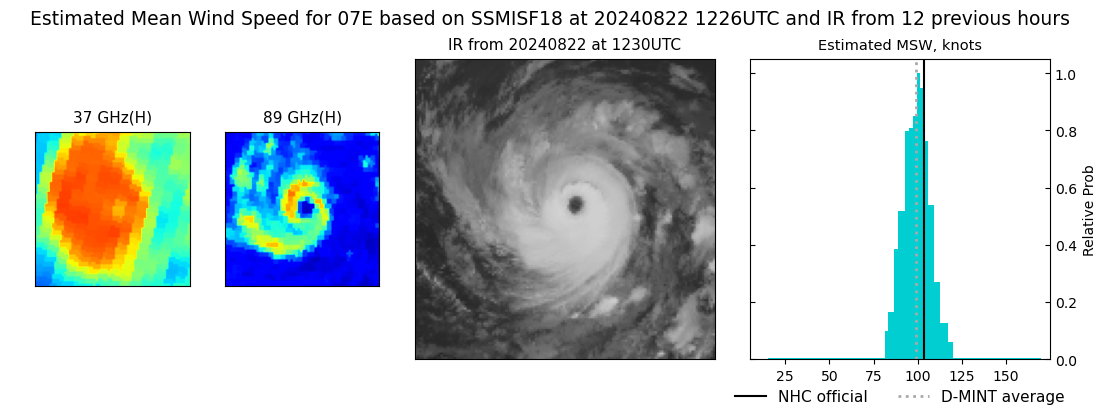 |
| 20240822 | 1016 UTC | AMSR2 | 959 hPa | 101 kts | 95 kts | 106 kts | 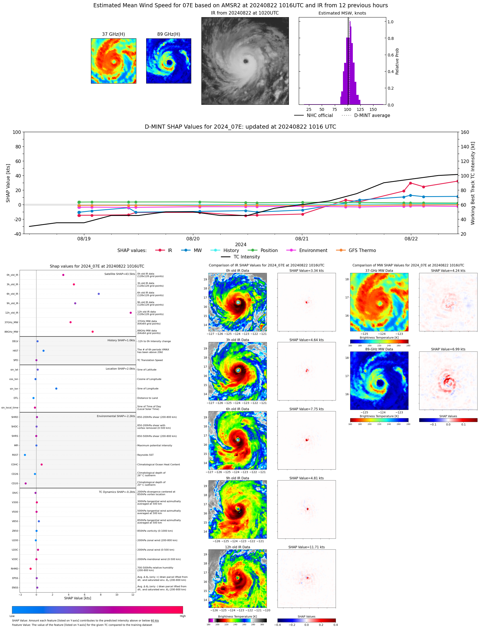 |
| 20240822 | 0936 UTC | ATMS-NPP | 961 hPa | 106 kts | 99 kts | 112 kts | 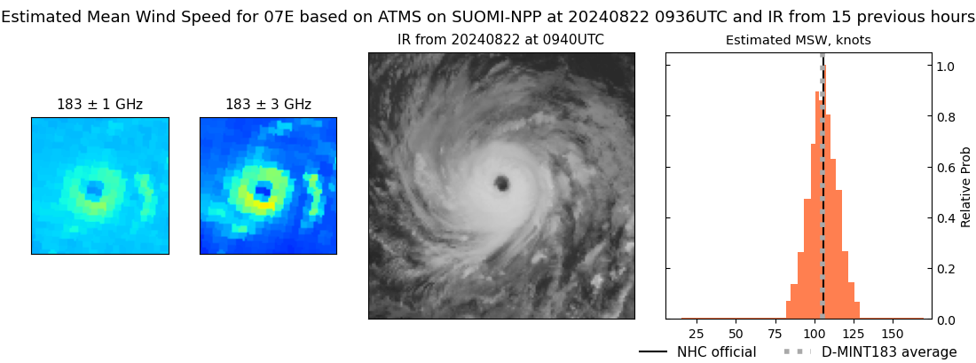 |
| 20240822 | 0243 UTC | SSMISF17 | 963 hPa | 97 kts | 91 kts | 103 kts | 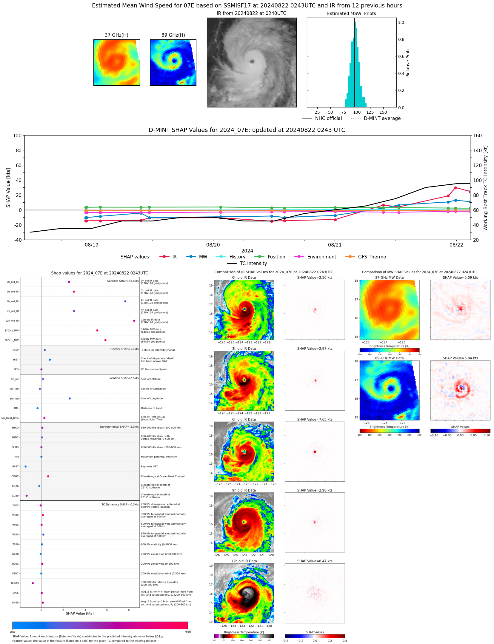 |
| 20240822 | 0202 UTC | SSMISF16 | 967 hPa | 97 kts | 90 kts | 104 kts | 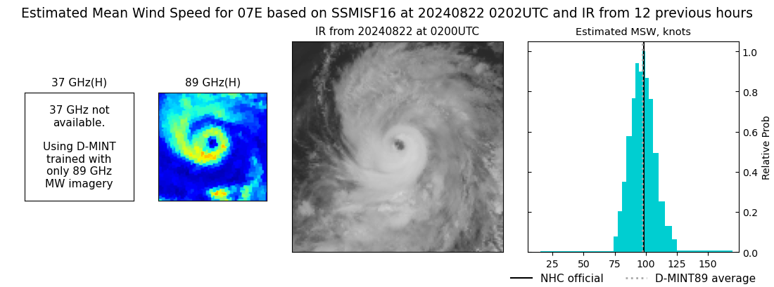 |
| 20240821 | 2351 UTC | SSMISF18 | 963 hPa | 100 kts | 95 kts | 106 kts | 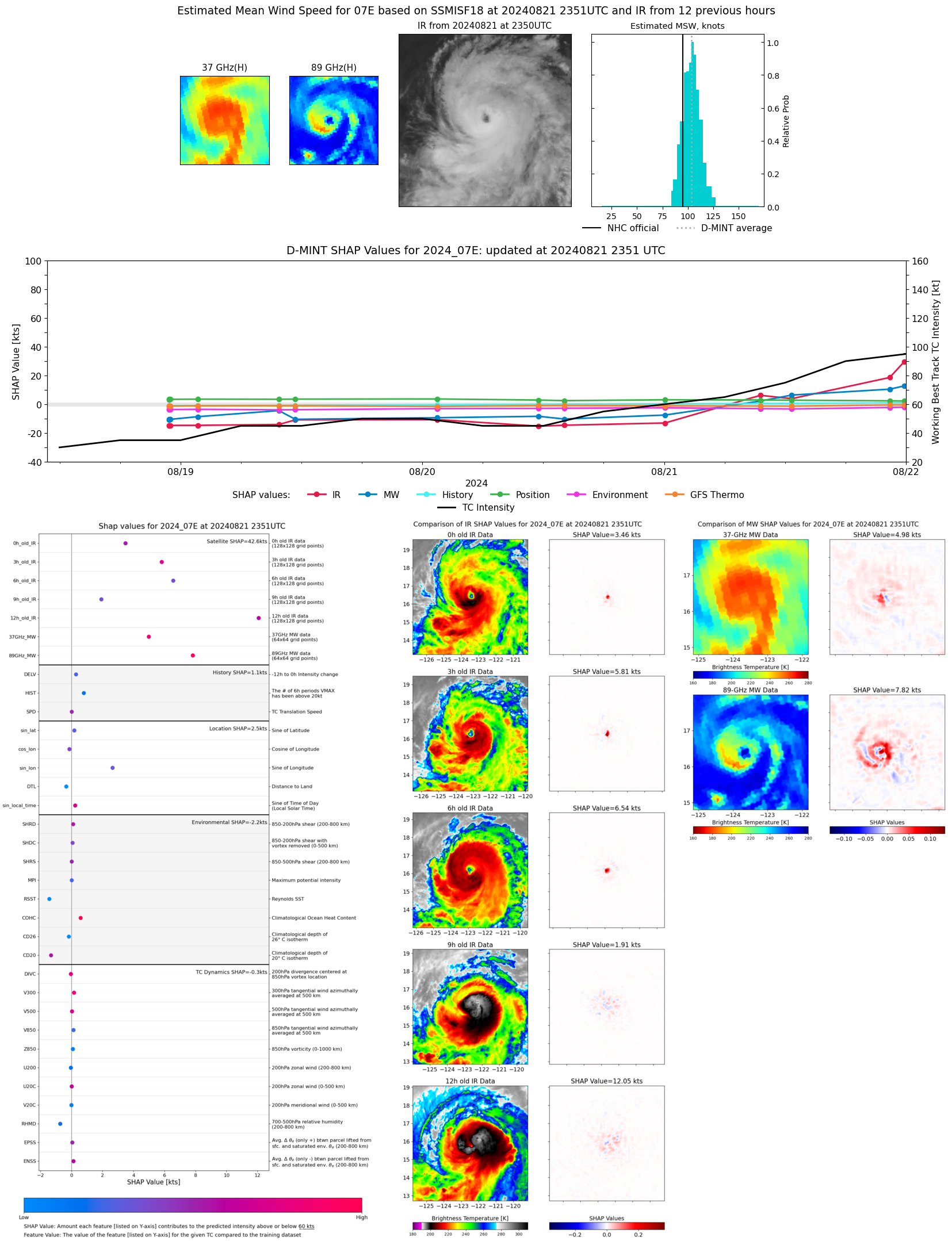 |
| 20240821 | 2223 UTC | GMI | 974 hPa | 90 kts | 84 kts | 95 kts | 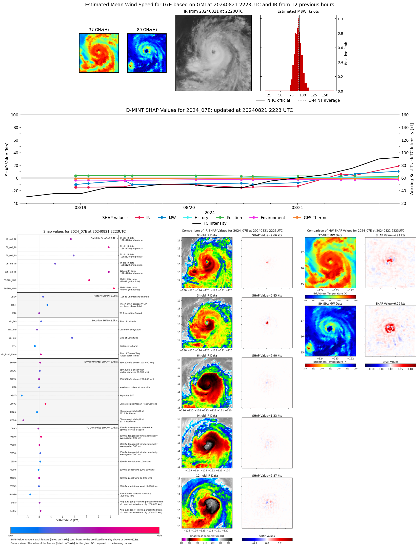 |
| 20240821 | 2142 UTC | TROPICS06 | 973 hPa | 91 kts | 86 kts | 97 kts | 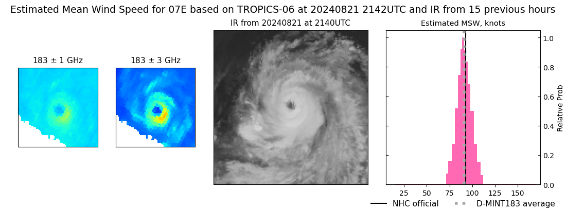 |
| 20240821 | 1451 UTC | SSMISF16 | 980 hPa | 80 kts | 74 kts | 87 kts | 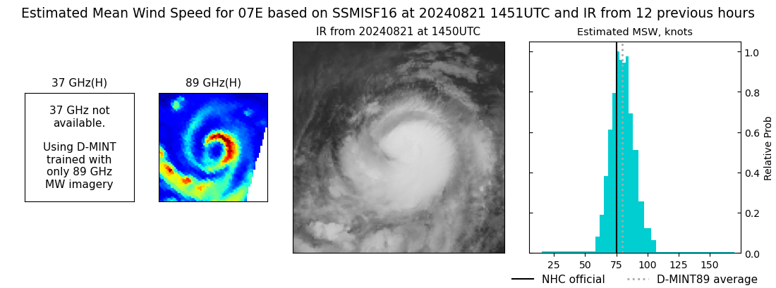 |
| 20240821 | 1240 UTC | SSMISF18 | 984 hPa | 69 kts | 64 kts | 75 kts | 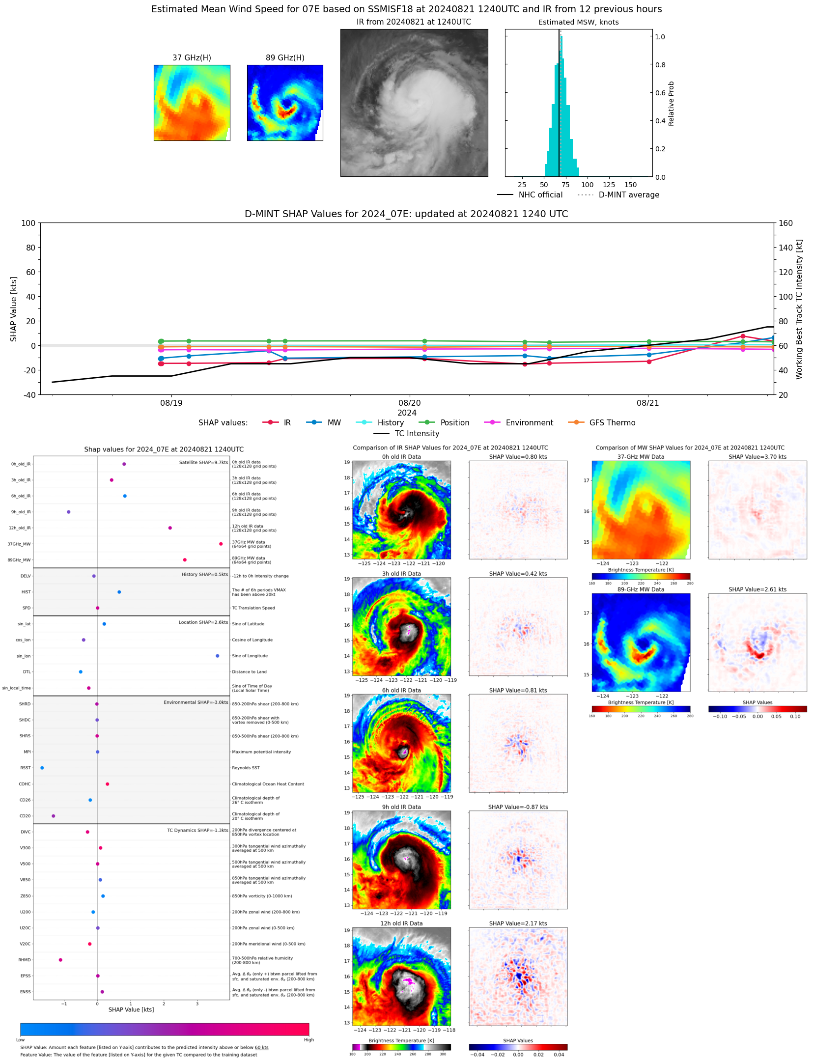 |
| 20240821 | 0952 UTC | TROPICS03 | 986 hPa | 71 kts | 65 kts | 78 kts | 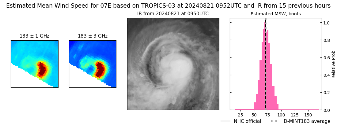 |
| 20240821 | 0933 UTC | AMSR2 | 989 hPa | 72 kts | 67 kts | 78 kts | 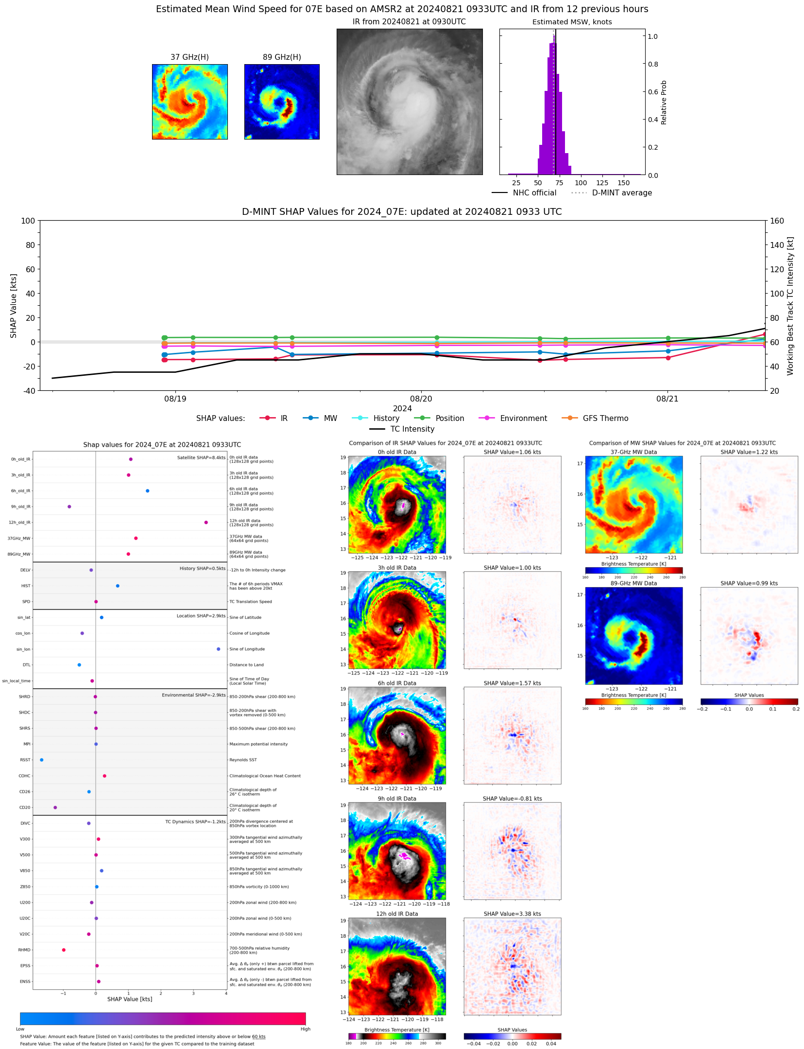 |
| 20240821 | 0216 UTC | SSMISF16 | 1001 hPa | 41 kts | 36 kts | 47 kts | 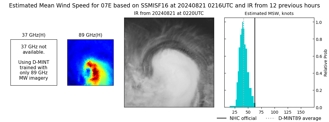 |
| 20240821 | 0005 UTC | SSMISF18 | 1002 hPa | 46 kts | 42 kts | 51 kts | 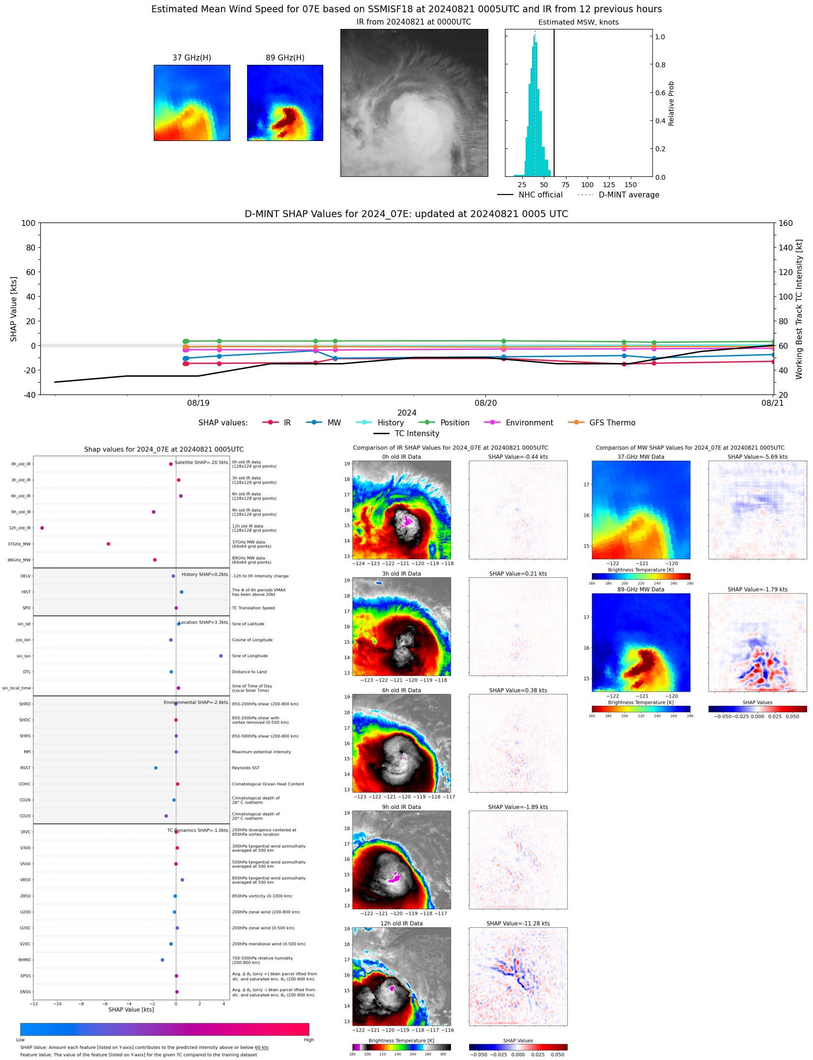 |
| 20240820 | 2207 UTC | TROPICS06 | 1002 hPa | 39 kts | 35 kts | 43 kts | 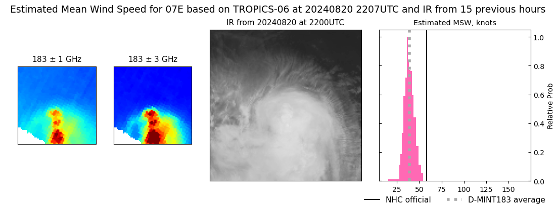 |
| 20240820 | 1404 UTC | SSMISF17 | 1005 hPa | 34 kts | 31 kts | 38 kts | 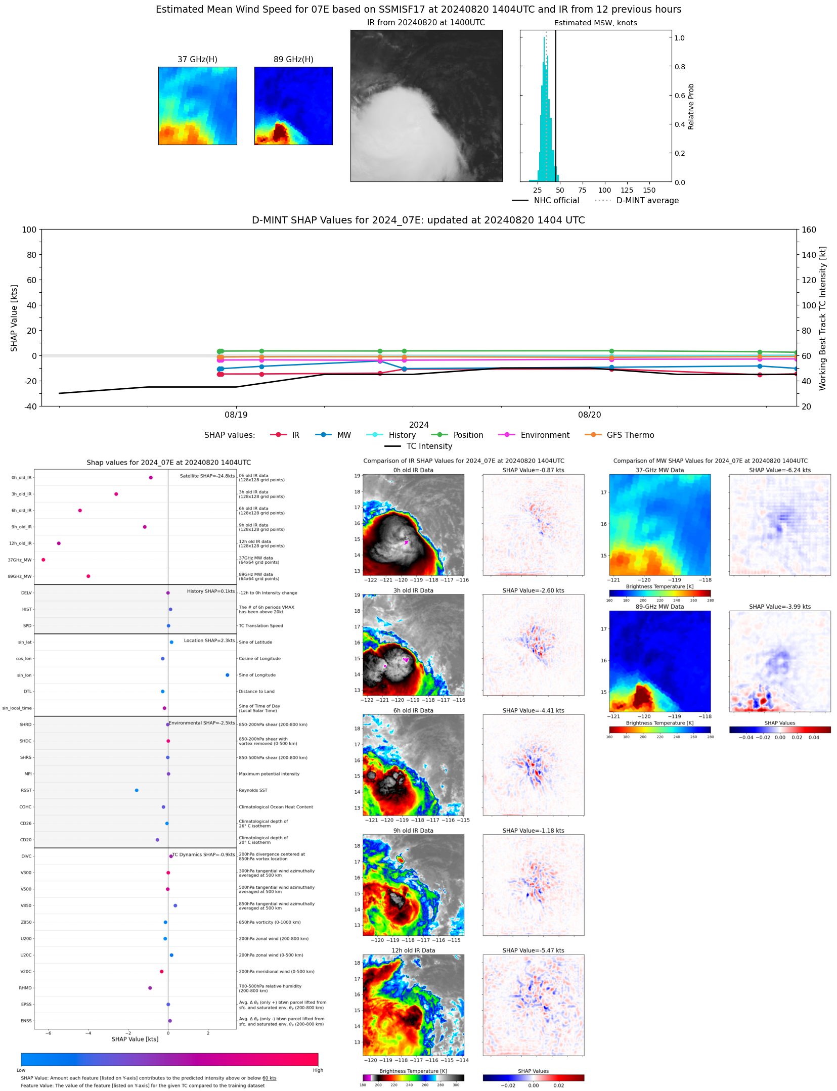 |
| 20240820 | 1345 UTC | TROPICS06 | 1003 hPa | 44 kts | 40 kts | 48 kts | 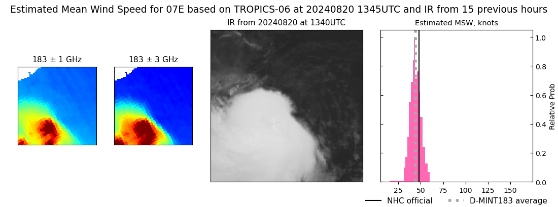 |
| 20240820 | 1133 UTC | GMI | 1004 hPa | 35 kts | 32 kts | 39 kts | 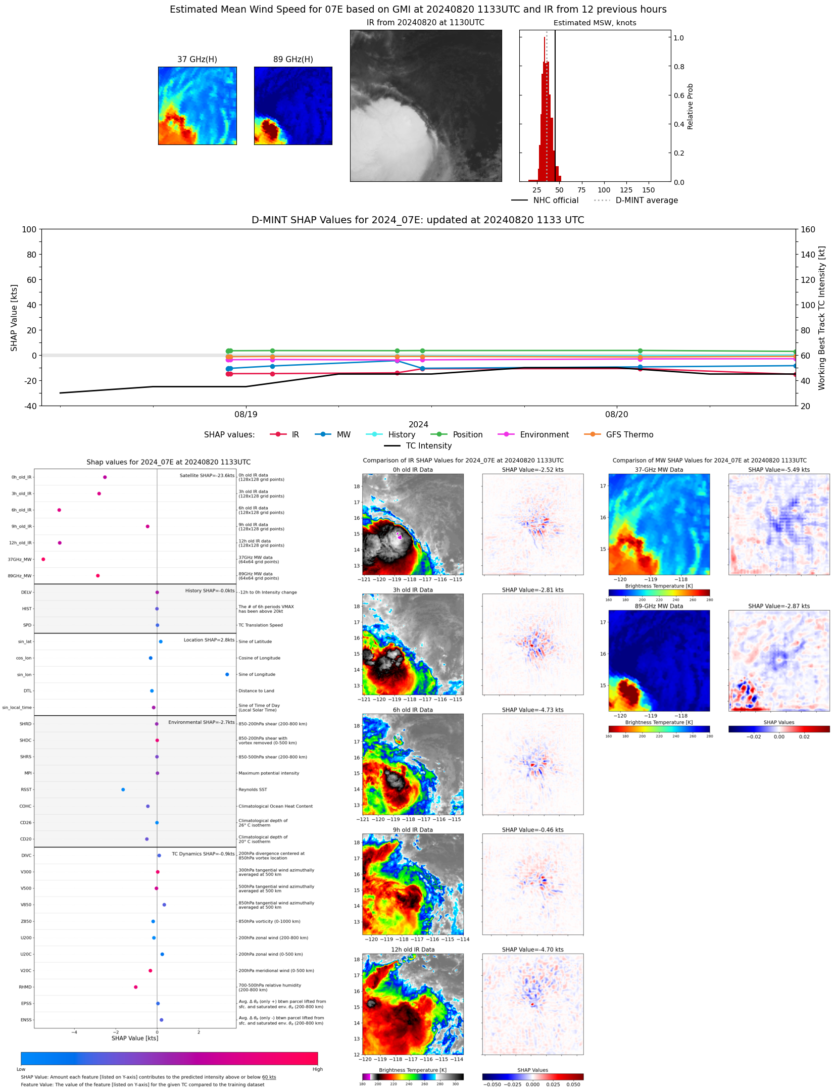 |
| 20240820 | 1014 UTC | TROPICS03 | 1003 hPa | 41 kts | 37 kts | 45 kts |  |
| 20240820 | 0150 UTC | TROPICS03 | 1003 hPa | 39 kts | 35 kts | 43 kts | 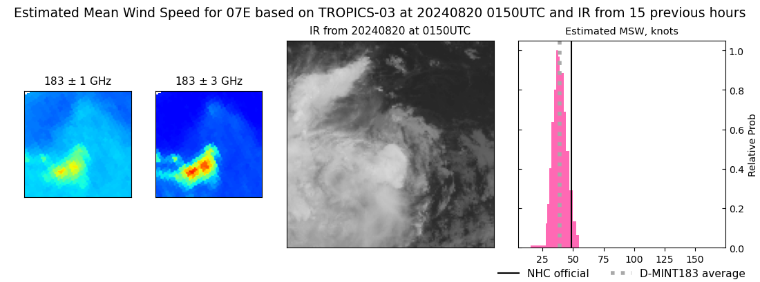 |
| 20240820 | 0129 UTC | SSMISF17 | 1003 hPa | 39 kts | 35 kts | 43 kts | 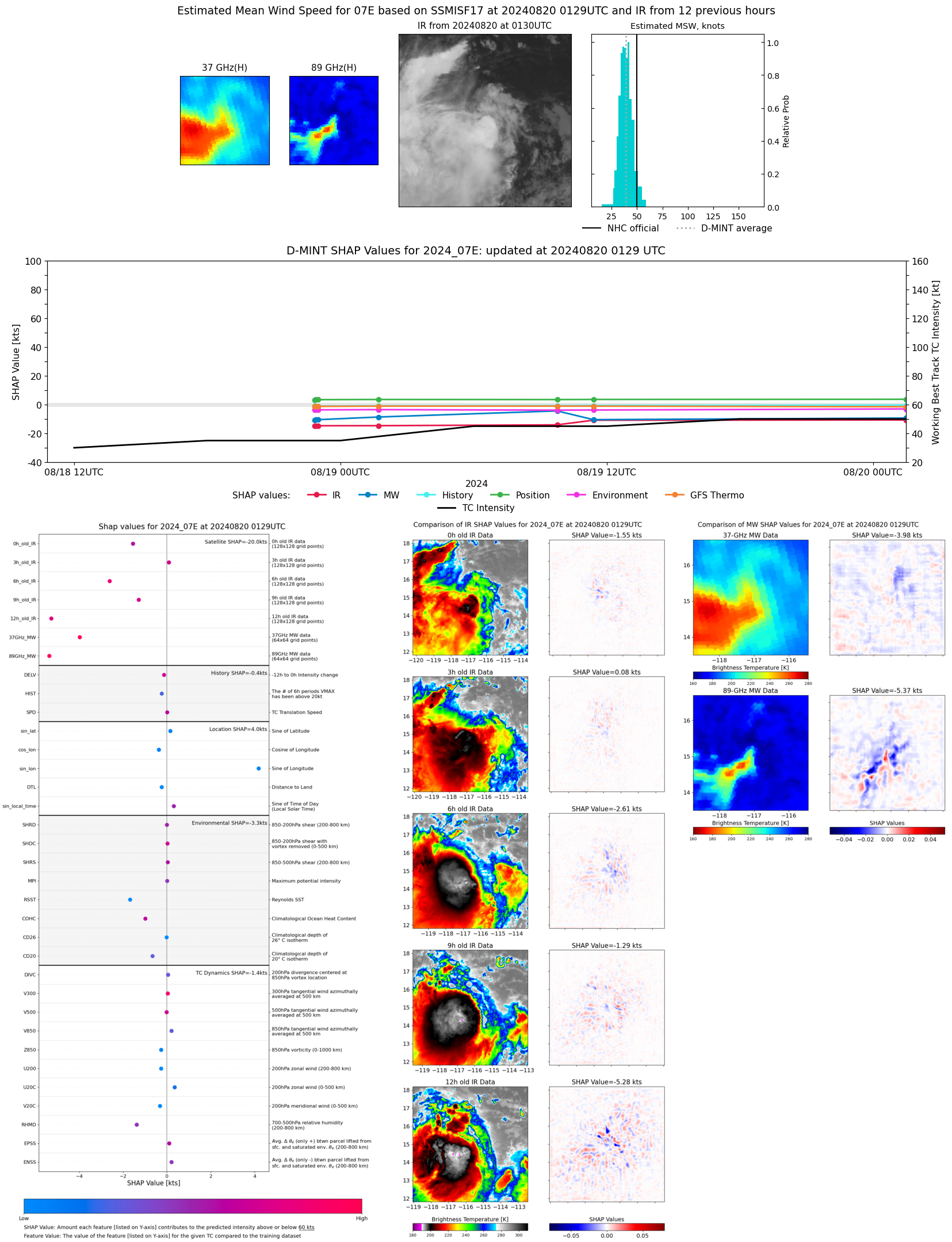 |
| 20240819 | 2233 UTC | TROPICS06 | 1002 hPa | 44 kts | 40 kts | 48 kts | 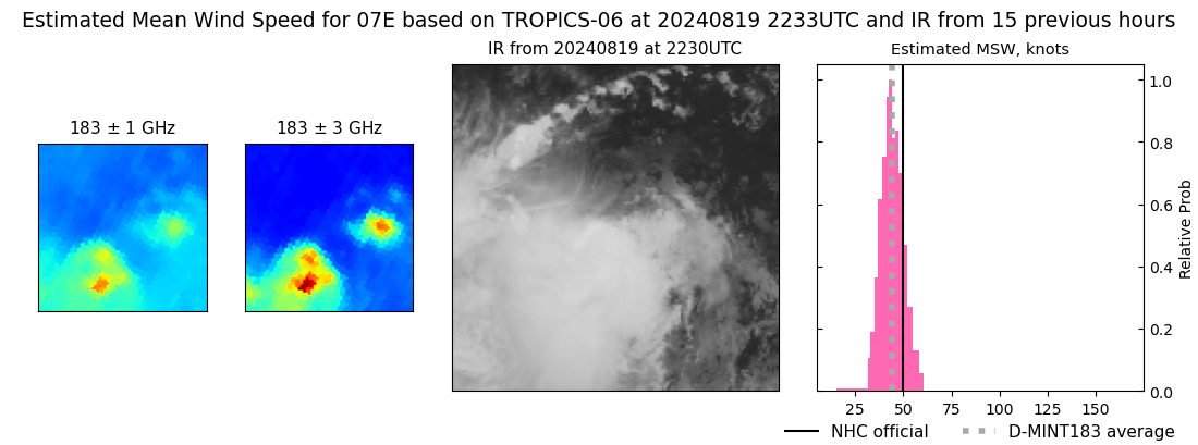 |
| 20240819 | 2117 UTC | ATMS-N21 | 997 hPa | 44 kts | 39 kts | 49 kts | 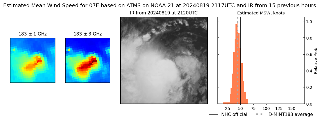 |
| 20240819 | 2026 UTC | ATMS-N20 | 995 hPa | 59 kts | 54 kts | 64 kts | 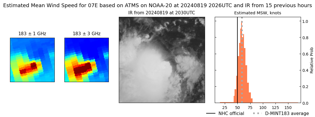 |
| 20240819 | 1418 UTC | SSMISF17 | 1003 hPa | 36 kts | 33 kts | 40 kts | 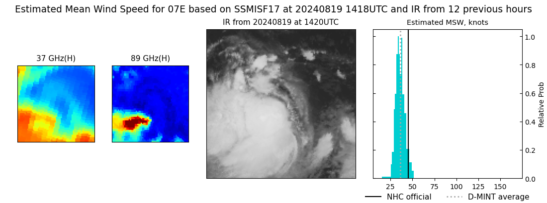 |
| 20240819 | 1410 UTC | TROPICS06 | 999 hPa | 47 kts | 42 kts | 52 kts | 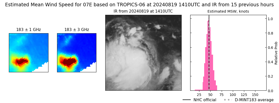 |
| 20240819 | 1124 UTC | SSMISF18 | 1004 hPa | 37 kts | 33 kts | 41 kts | 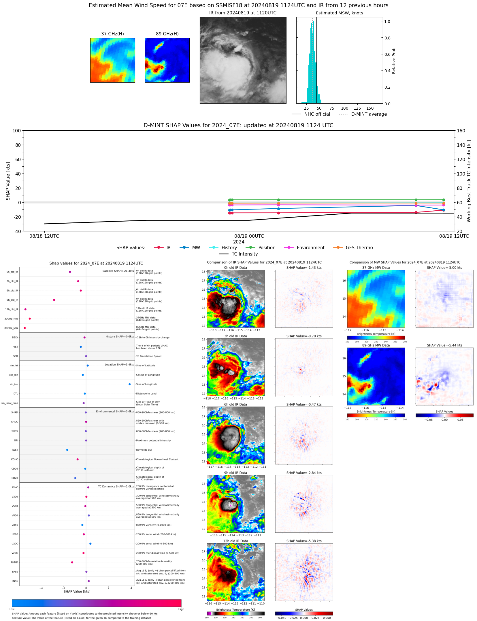 |
| 20240819 | 1037 UTC | TROPICS03 | 1002 hPa | 40 kts | 36 kts | 45 kts |  |
| 20240819 | 0946 UTC | AMSR2 | 1004 hPa | 37 kts | 34 kts | 41 kts | 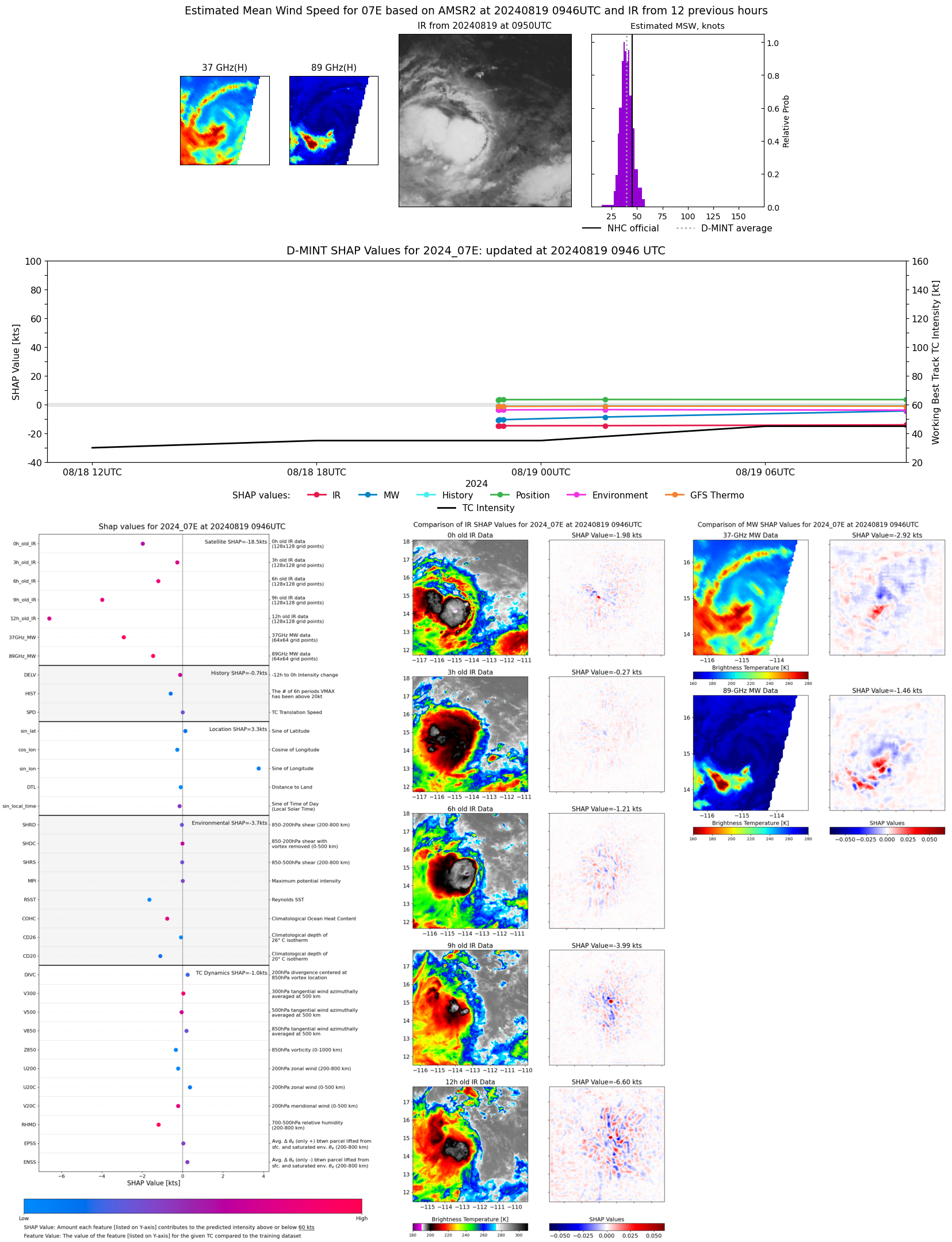 |
| 20240819 | 0917 UTC | ATMS-N20 | 1002 hPa | 36 kts | 33 kts | 41 kts | 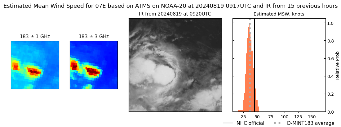 |
| 20240819 | 0853 UTC | ATMS-NPP | 1002 hPa | 38 kts | 34 kts | 42 kts | 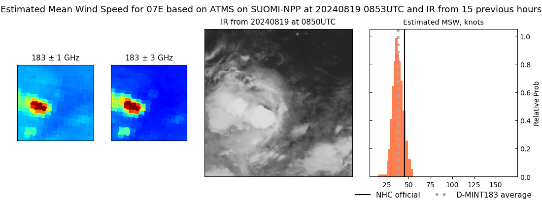 |
| 20240819 | 0143 UTC | SSMISF17 | 1006 hPa | 35 kts | 32 kts | 39 kts |  |
| 20240819 | 0102 UTC | SSMISF16 | 1005 hPa | 31 kts | 28 kts | 35 kts | 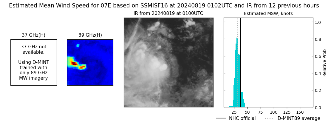 |
| 20240818 | 2300 UTC | GMI | 1006 hPa | 33 kts | 30 kts | 36 kts | 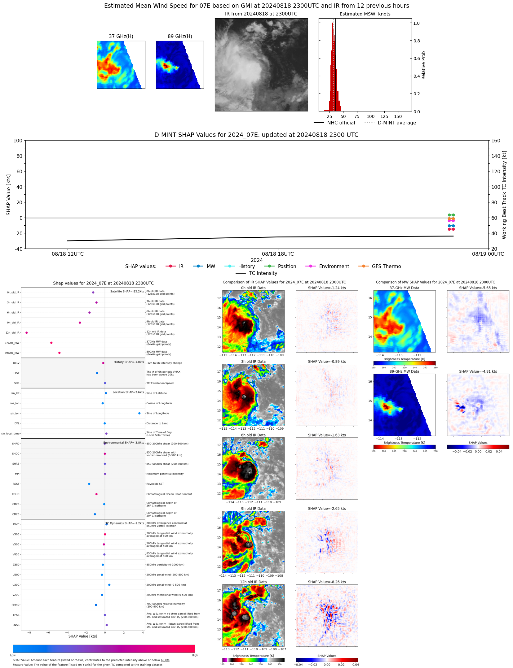 |
| 20240818 | 2258 UTC | TROPICS06 | 1004 hPa | 33 kts | 30 kts | 36 kts | 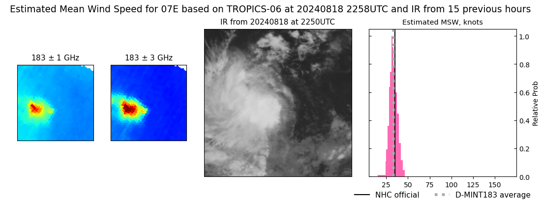 |
| 20240818 | 2253 UTC | GMI | 1006 hPa | 32 kts | 30 kts | 36 kts |  |
| 20240818 | 2251 UTC | SSMISF18 | 1006 hPa | 32 kts | 29 kts | 36 kts | 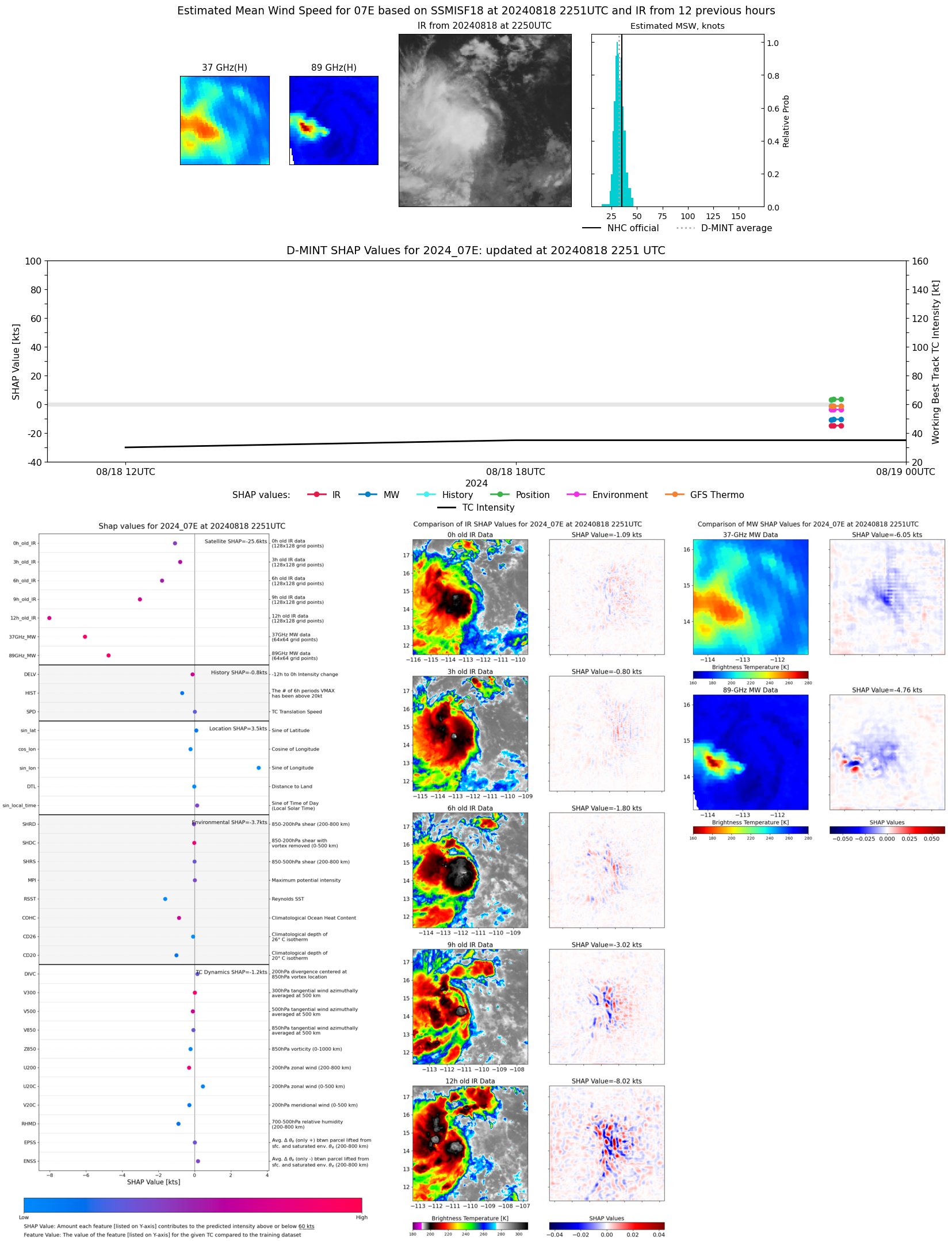 |
| 20240818 | 2044 UTC | ATMS-N20 | 1004 hPa | 30 kts | 27 kts | 34 kts | 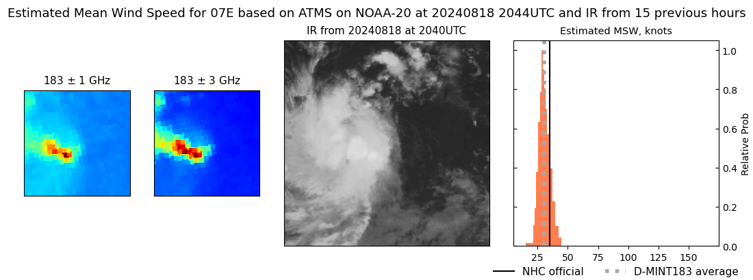 |
| 20240818 | 2020 UTC | ATMS-NPP | 1004 hPa | 32 kts | 29 kts | 36 kts |  |
| 20240818 | 1100 UTC | TROPICS03 | 1009 hPa | 28 kts | 26 kts | 31 kts | 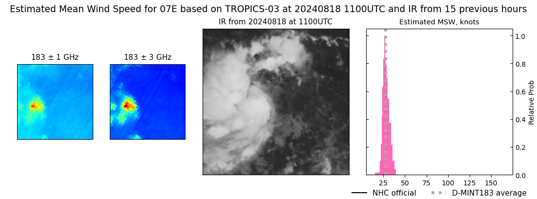 |