|
||

 |
D-MINT HISTORY FILE for 2025_05L
| Date | Time | MW Sensor | MSLP | Vmax (30th-70th percentile average) | Vmax 25th percentile | Vmax 75th percentile | Image |
| 20250823 | 0658 UTC | GMI | 980 hPa | 57 kts | 51 kts | 64 kts |  |
| 20250823 | 0525 UTC | AMSR2 | 981 hPa | 59 kts | 53 kts | 66 kts |  |
| 20250822 | 2248 UTC | GMI | 976 hPa | 68 kts | 61 kts | 75 kts |  |
| 20250822 | 2139 UTC | SSMISF17 | 976 hPa | 69 kts | 62 kts | 76 kts | 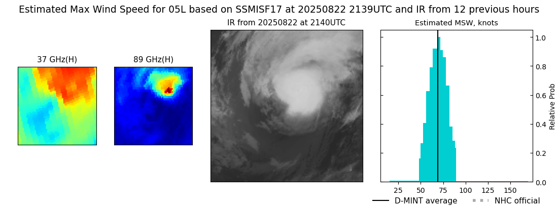 |
| 20250822 | 1725 UTC | AMSR2 | 974 hPa | 74 kts | 67 kts | 80 kts |  |
| 20250822 | 1511 UTC | AWS | 976 hPa | 60 kts | 56 kts | 64 kts | 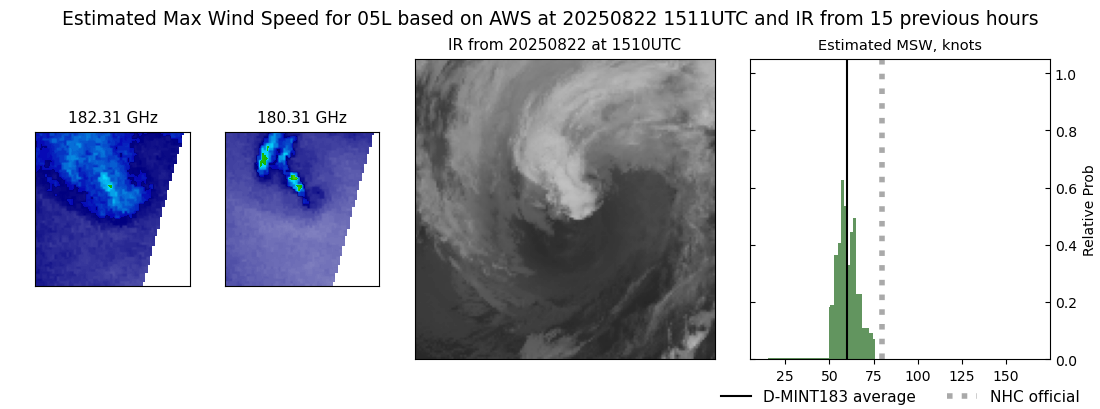 |
| 20250822 | 1016 UTC | SSMISF17 | 960 hPa | 83 kts | 76 kts | 90 kts |  |
| 20250822 | 0853 UTC | SSMISF18 | 962 hPa | 84 kts | 77 kts | 91 kts | 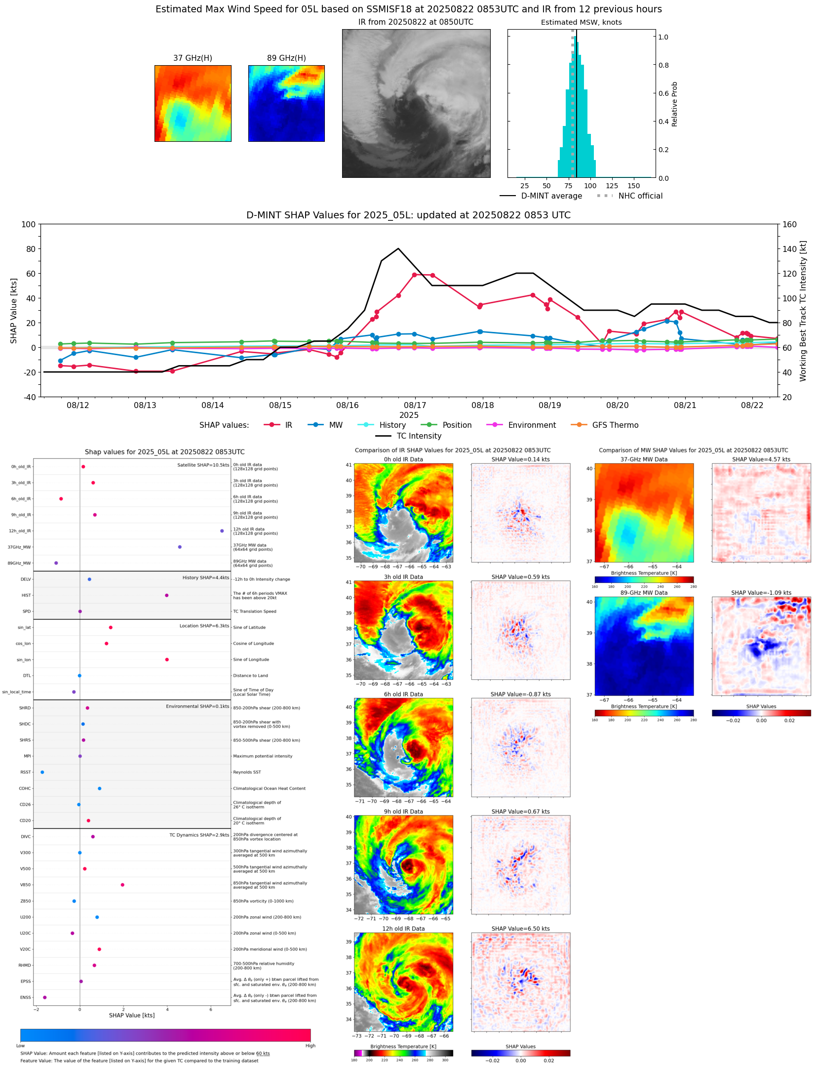 |
| 20250822 | 0639 UTC | ATMS-N21 | 963 hPa | 75 kts | 70 kts | 80 kts | 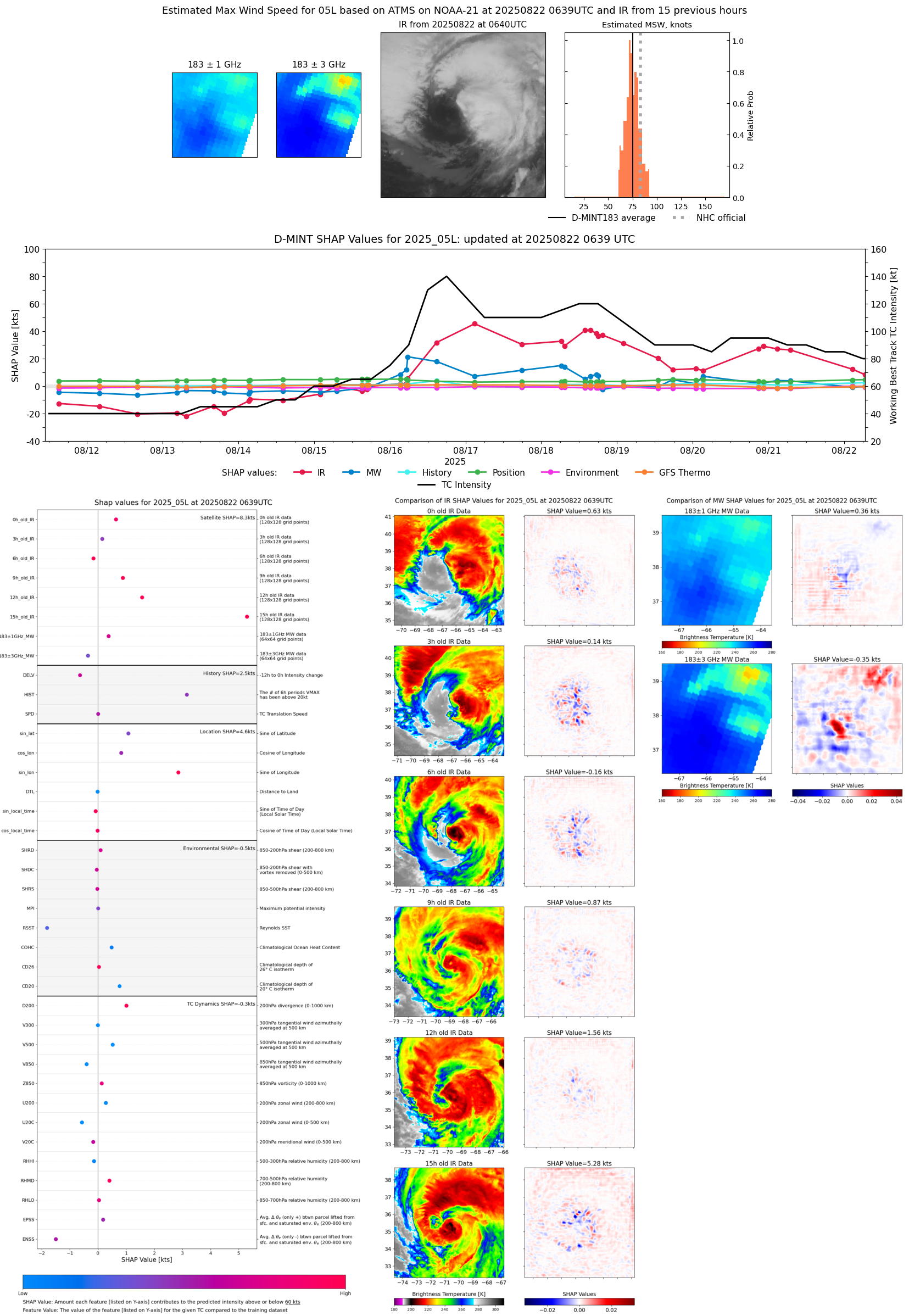 |
| 20250822 | 0621 UTC | AMSR2 | 962 hPa | 80 kts | 74 kts | 86 kts | 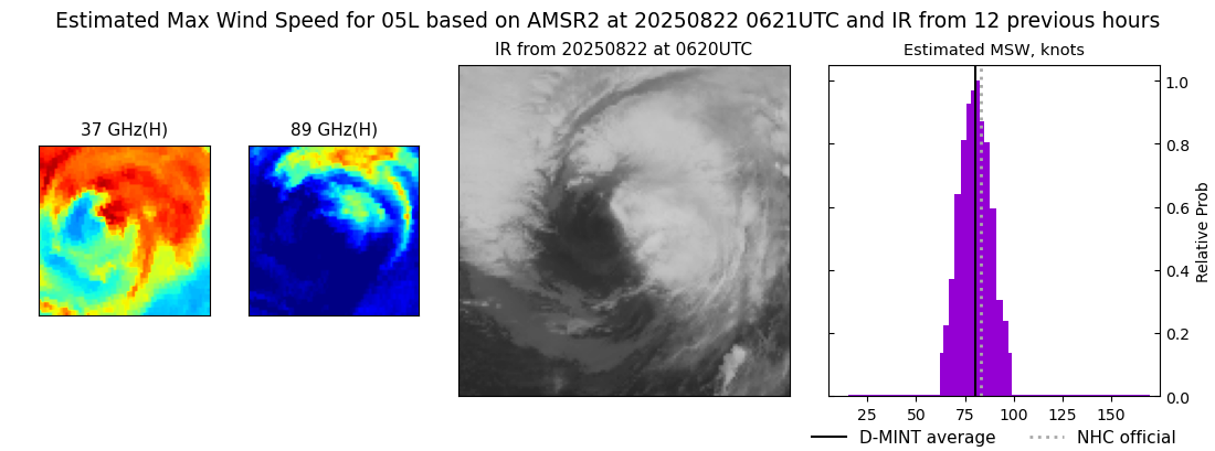 |
| 20250822 | 0240 UTC | TMS02 | 965 hPa | 78 kts | 74 kts | 83 kts | 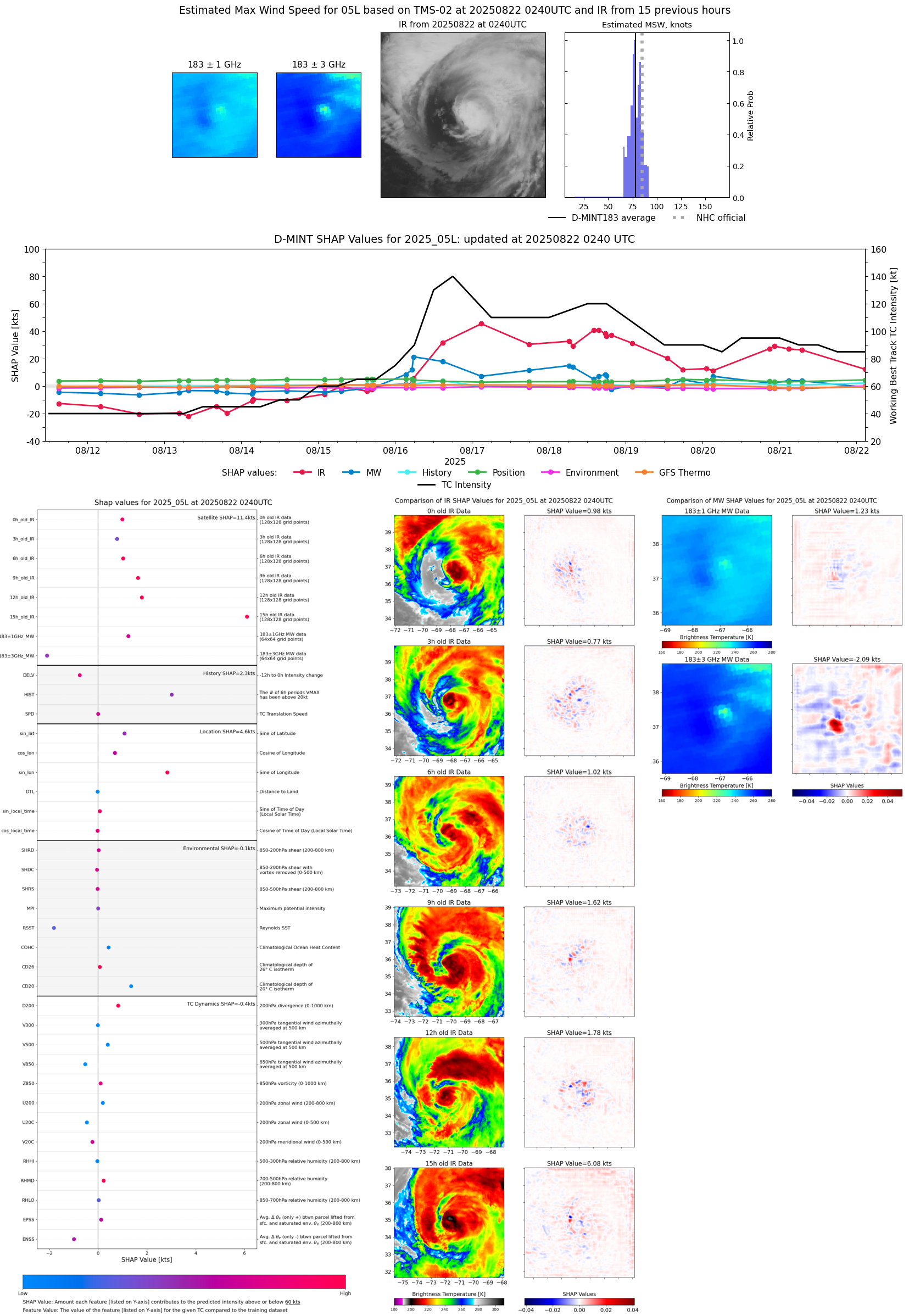 |
| 20250821 | 2328 UTC | GMI | 958 hPa | 84 kts | 77 kts | 91 kts |  |
| 20250821 | 2223 UTC | SSMISF16 | 955 hPa | 87 kts | 80 kts | 94 kts | 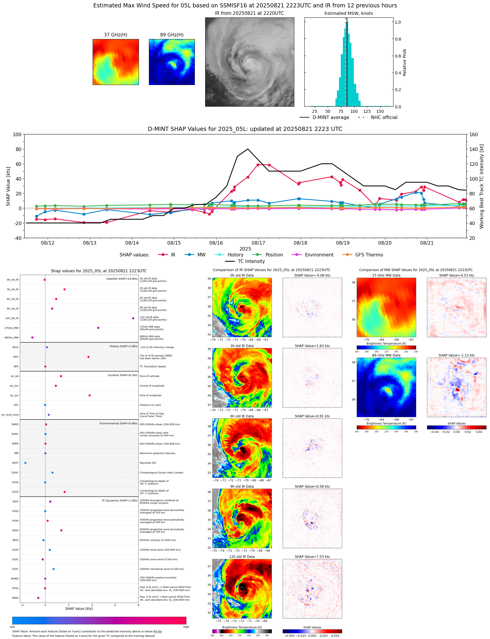 |
| 20250821 | 2153 UTC | SSMISF17 | 955 hPa | 89 kts | 82 kts | 96 kts |  |
| 20250821 | 2030 UTC | SSMISF18 | 960 hPa | 88 kts | 82 kts | 95 kts |  |
| 20250821 | 2030 UTC | SSMISF18 | 960 hPa | 88 kts | 82 kts | 95 kts | 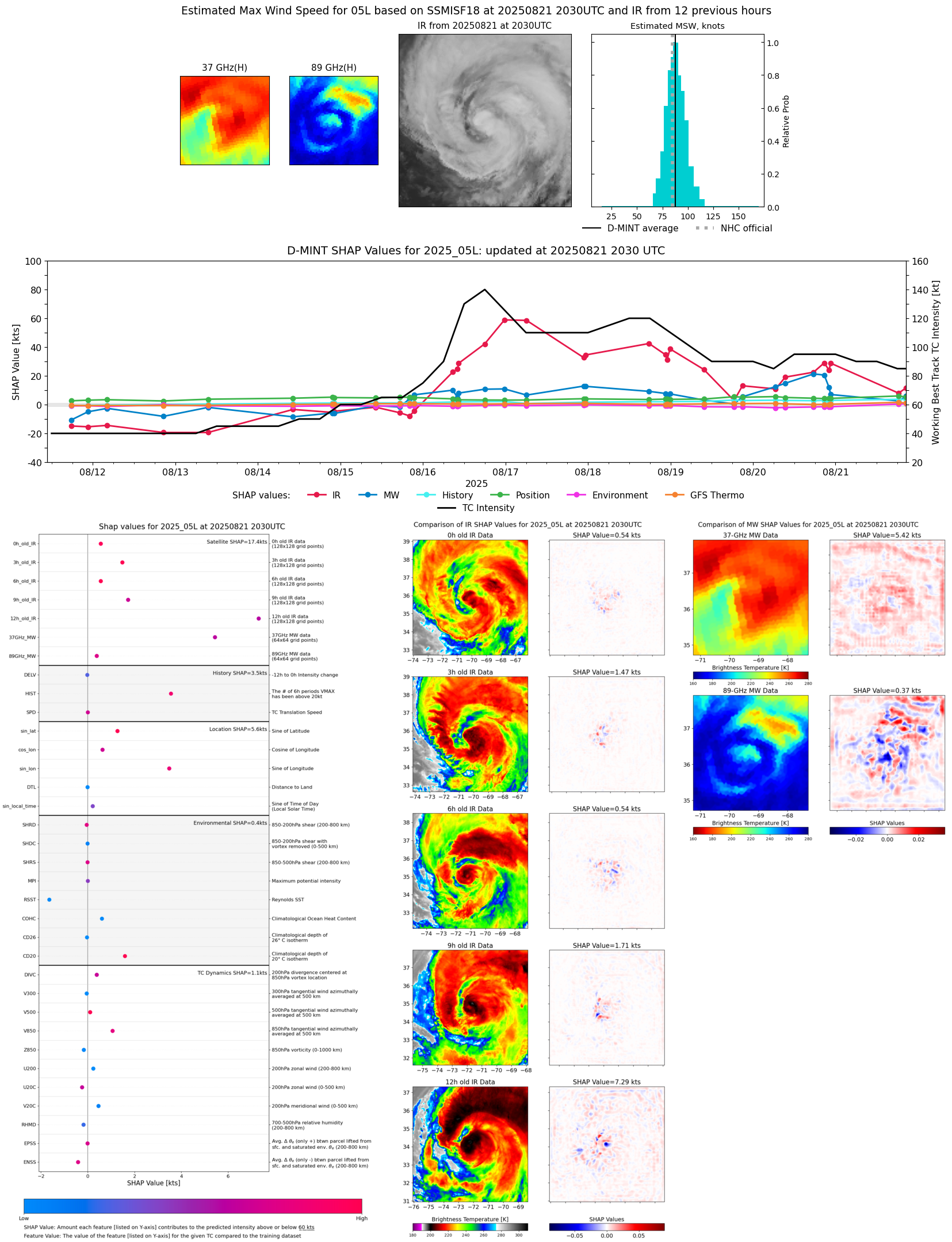 |
| 20250821 | 1821 UTC | AMSR2 | 962 hPa | 82 kts | 76 kts | 88 kts |  |
| 20250821 | 0924 UTC | TROPICS03 | 959 hPa | 90 kts | 86 kts | 95 kts | 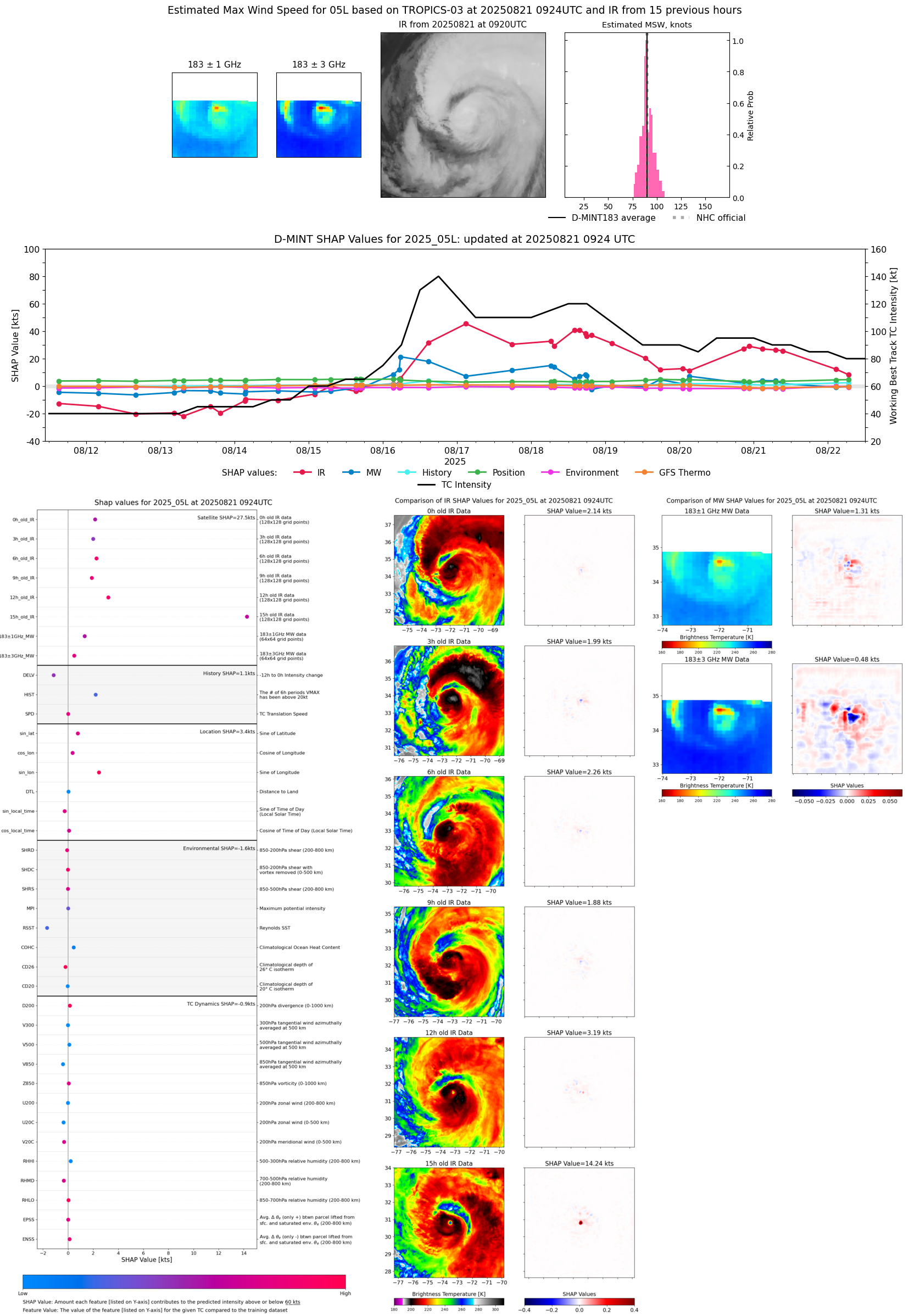 |
| 20250821 | 0659 UTC | ATMS-N21 | 954 hPa | 92 kts | 89 kts | 97 kts |  |
| 20250821 | 0251 UTC | TMS02 | 952 hPa | 93 kts | 90 kts | 98 kts |  |
| 20250820 | 2236 UTC | SSMISF16 | 960 hPa | 102 kts | 97 kts | 107 kts |  |
| 20250820 | 2227 UTC | TROPICS05 | 959 hPa | 94 kts | 90 kts | 99 kts |  |
| 20250820 | 2207 UTC | SSMISF17 | 959 hPa | 102 kts | 96 kts | 108 kts |  |
| 20250820 | 2049 UTC | TROPICS05 | 959 hPa | 93 kts | 89 kts | 98 kts | 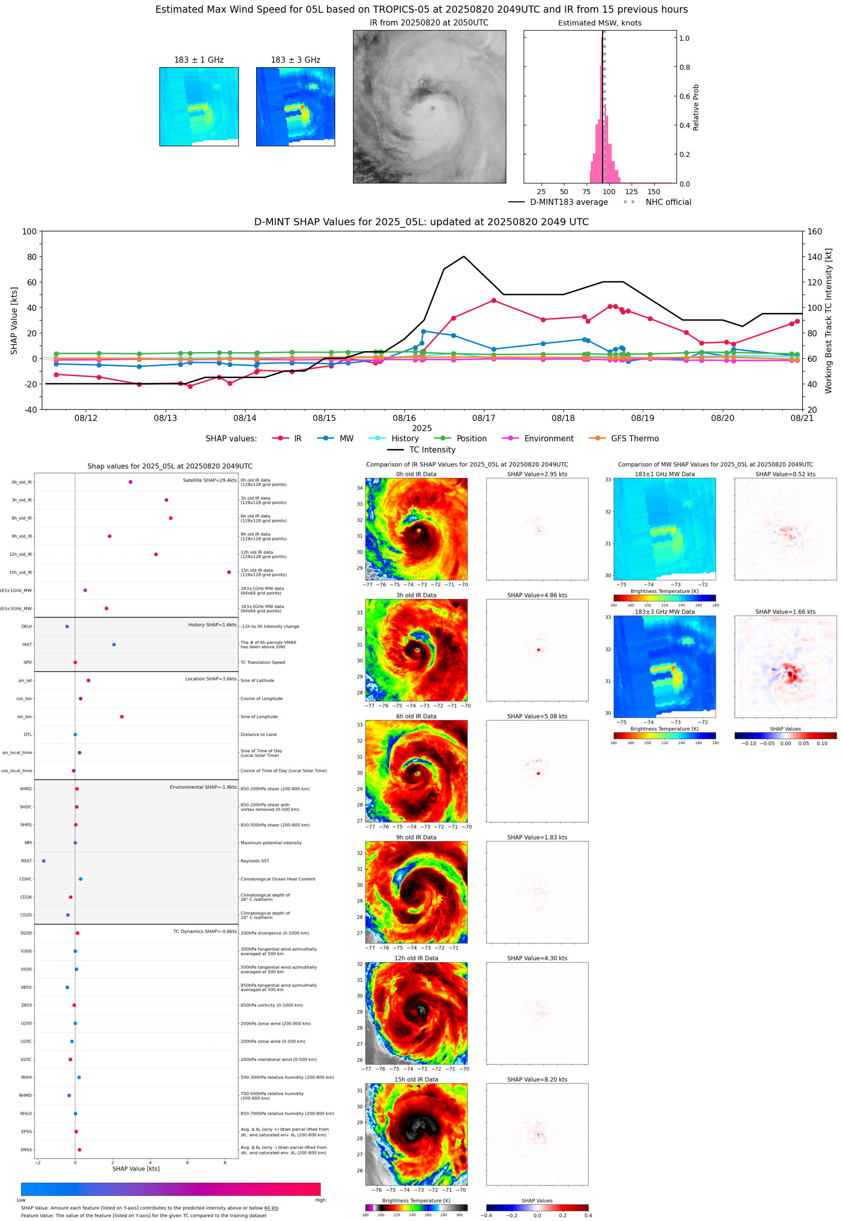 |
| 20250820 | 2043 UTC | SSMISF18 | 950 hPa | 115 kts | 109 kts | 122 kts |  |
| 20250820 | 1737 UTC | AMSR2 | 955 hPa | 109 kts | 103 kts | 117 kts |  |
| 20250820 | 0923 UTC | SSMISF18 | 964 hPa | 100 kts | 93 kts | 108 kts | 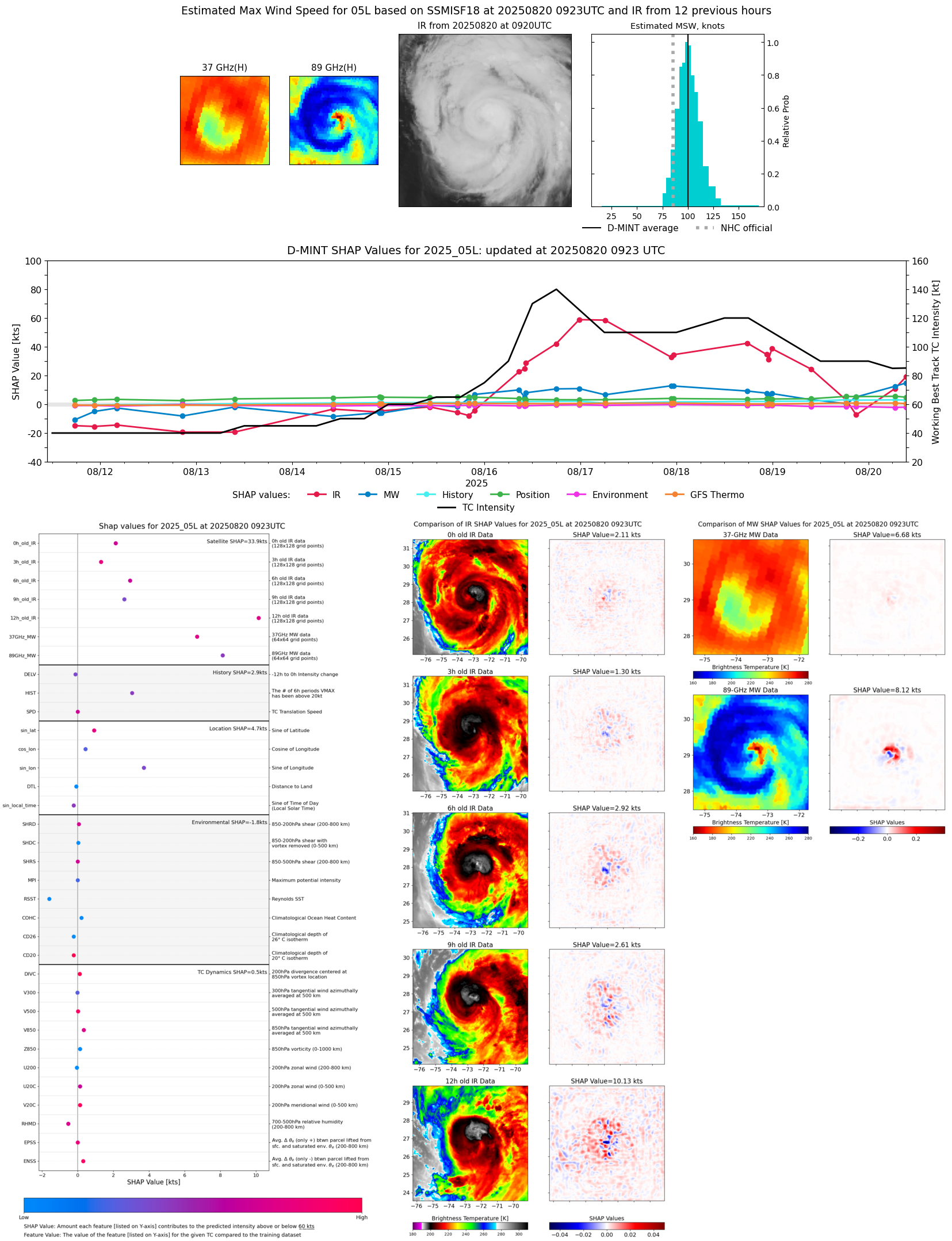 |
| 20250820 | 0636 UTC | AMSR2 | 964 hPa | 91 kts | 84 kts | 98 kts | 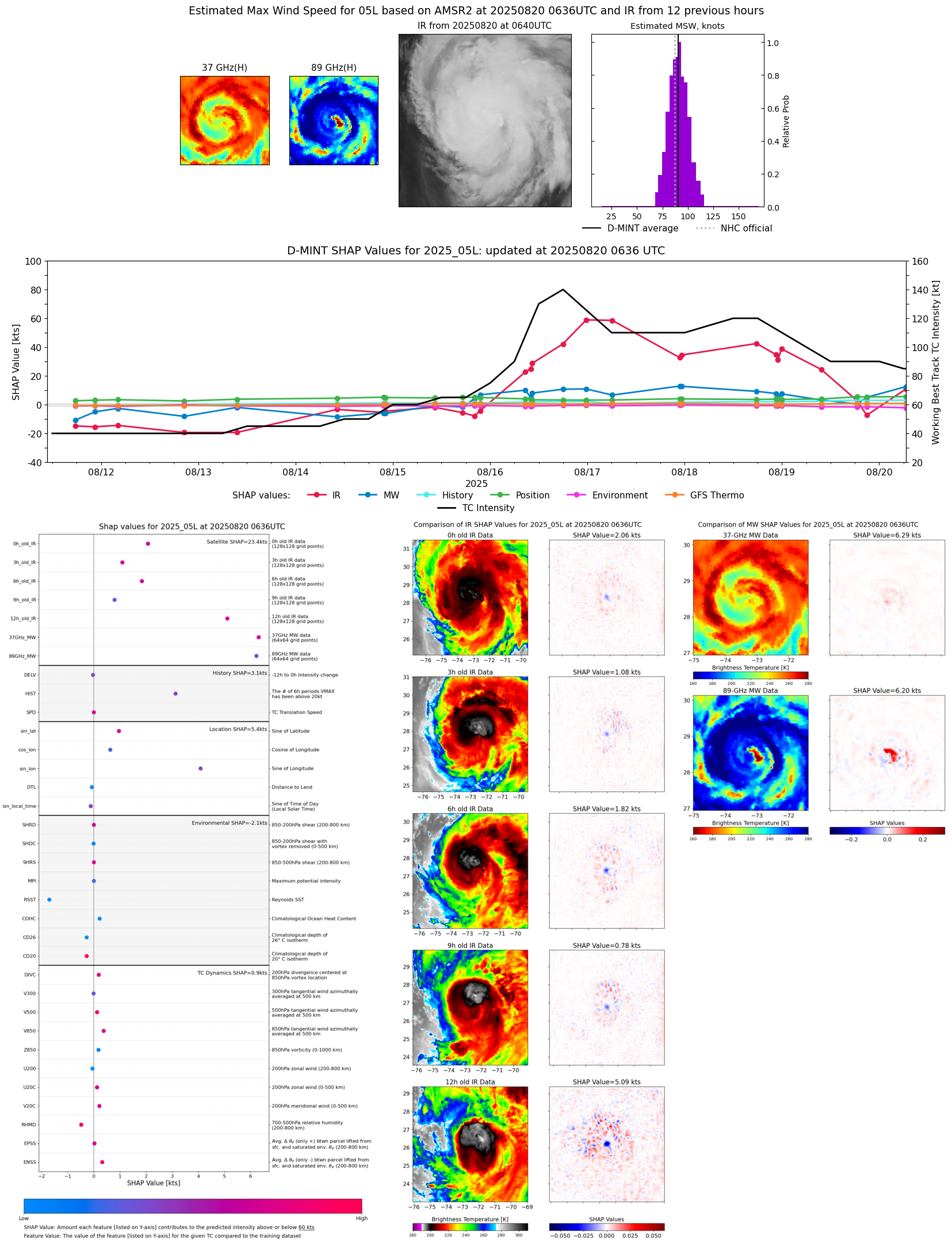 |
| 20250820 | 0313 UTC | TMS02 | 967 hPa | 84 kts | 79 kts | 90 kts | 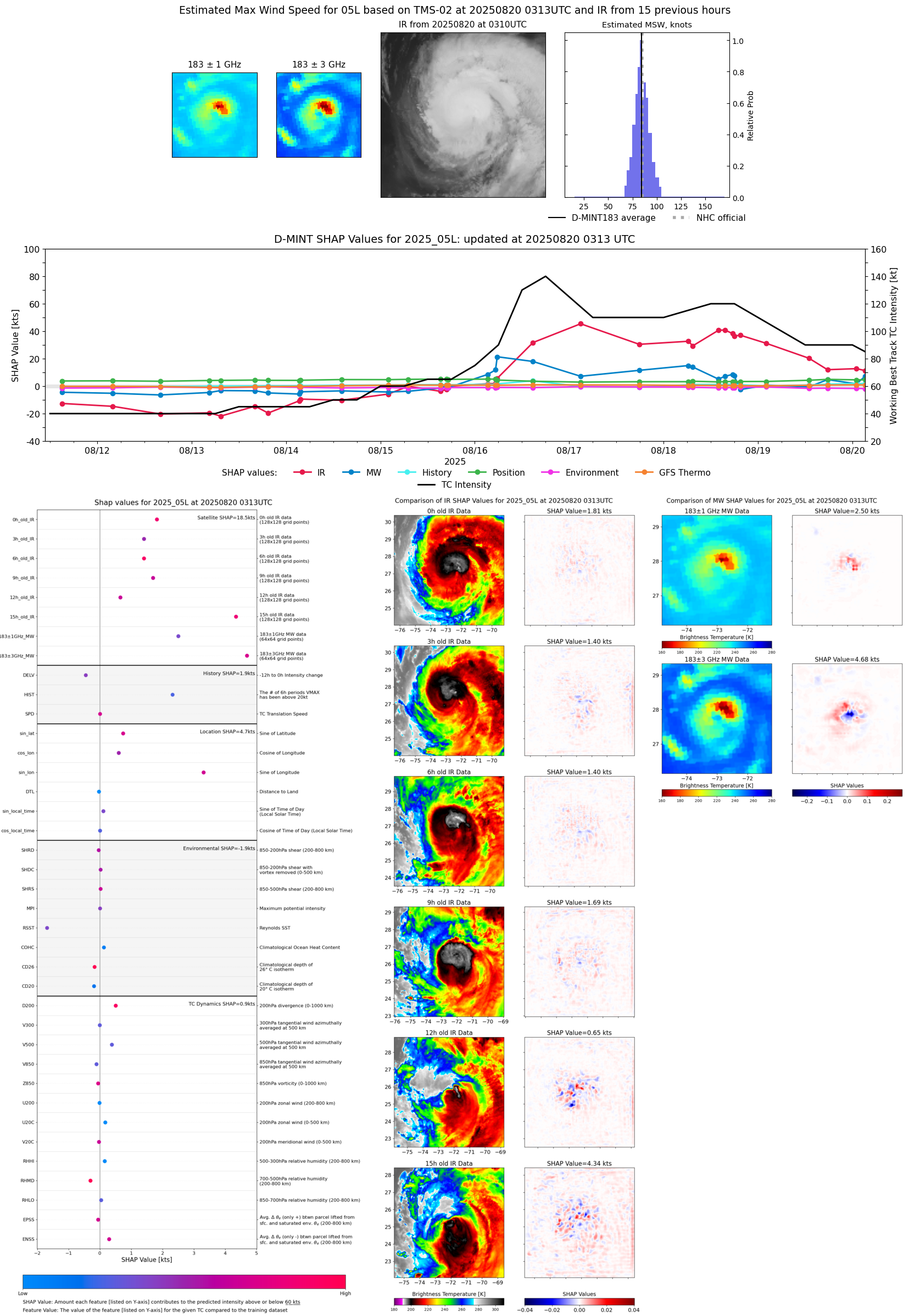 |
| 20250820 | 0303 UTC | AWS | 985 hPa | 74 kts | 68 kts | 80 kts | 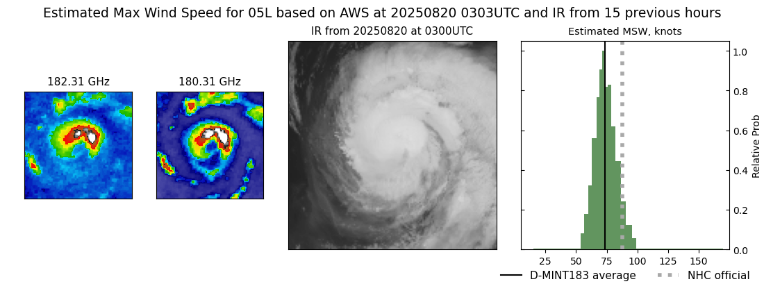 |
| 20250820 | 0103 UTC | TROPICS05 | 971 hPa | 81 kts | 75 kts | 86 kts |  |
| 20250819 | 2056 UTC | SSMISF18 | 967 hPa | 86 kts | 80 kts | 92 kts | 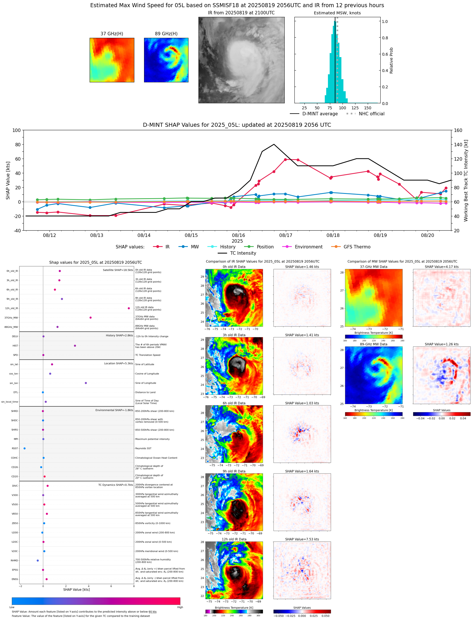 |
| 20250819 | 1830 UTC | AMSR2 | 973 hPa | 71 kts | 65 kts | 77 kts | 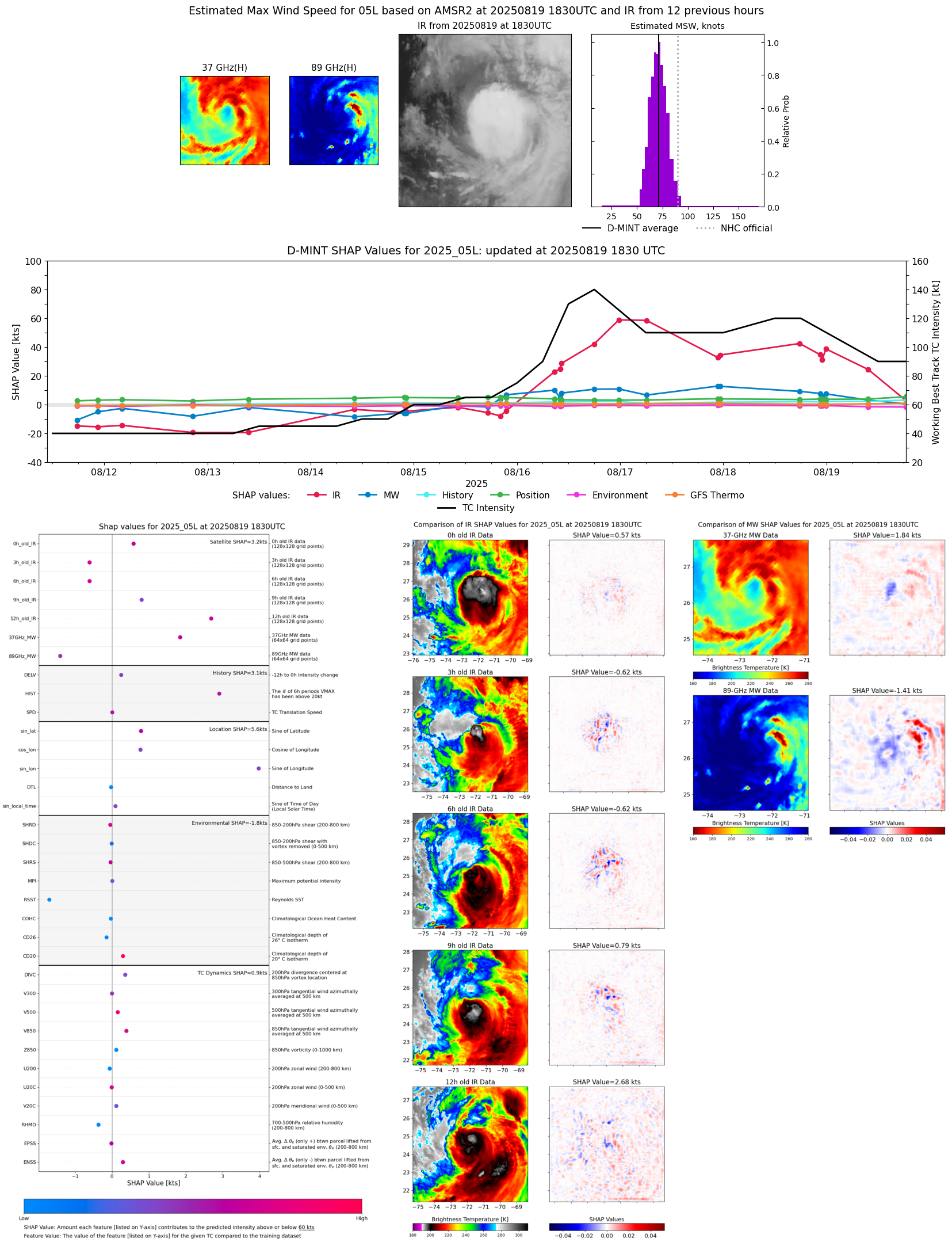 |
| 20250819 | 1740 UTC | ATMS-NPP | 968 hPa | 83 kts | 77 kts | 89 kts | 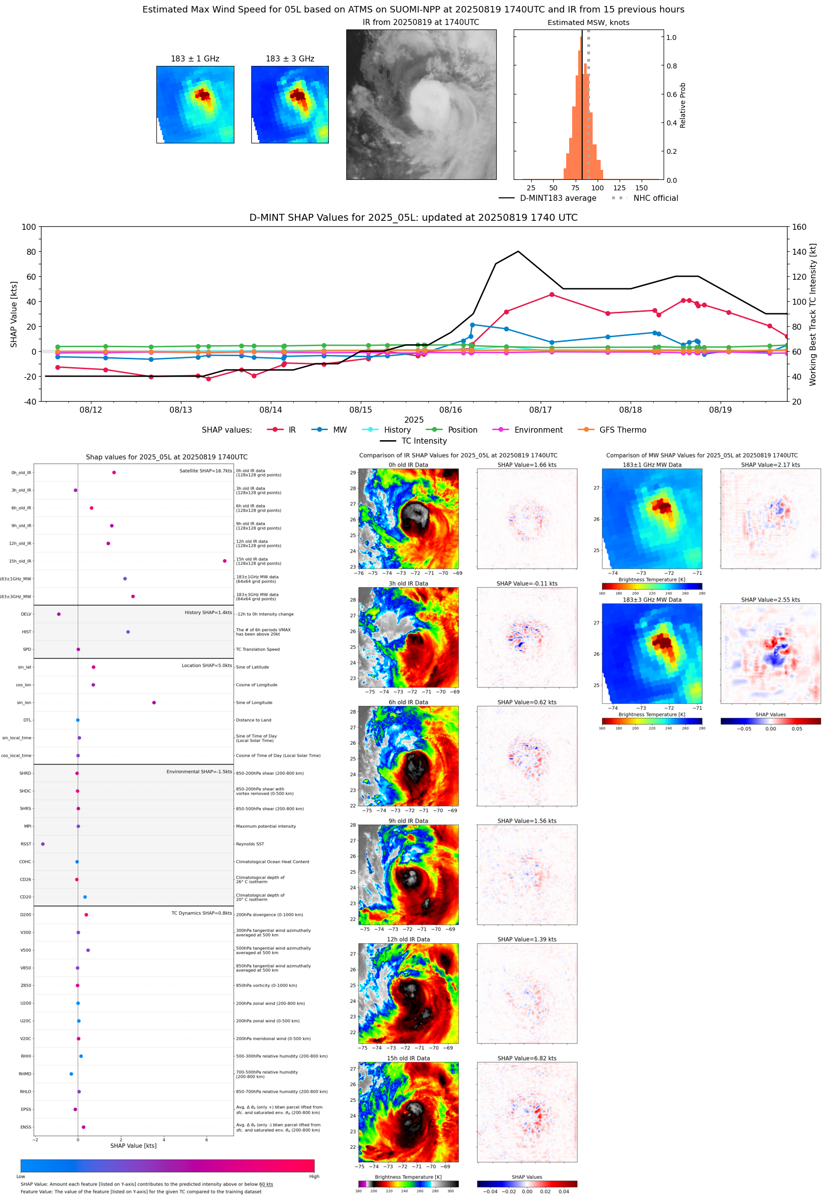 |
| 20250819 | 1258 UTC | TROPICS03 | 965 hPa | 84 kts | 78 kts | 90 kts |  |
| 20250819 | 0943 UTC | GMI | 963 hPa | 93 kts | 87 kts | 99 kts | 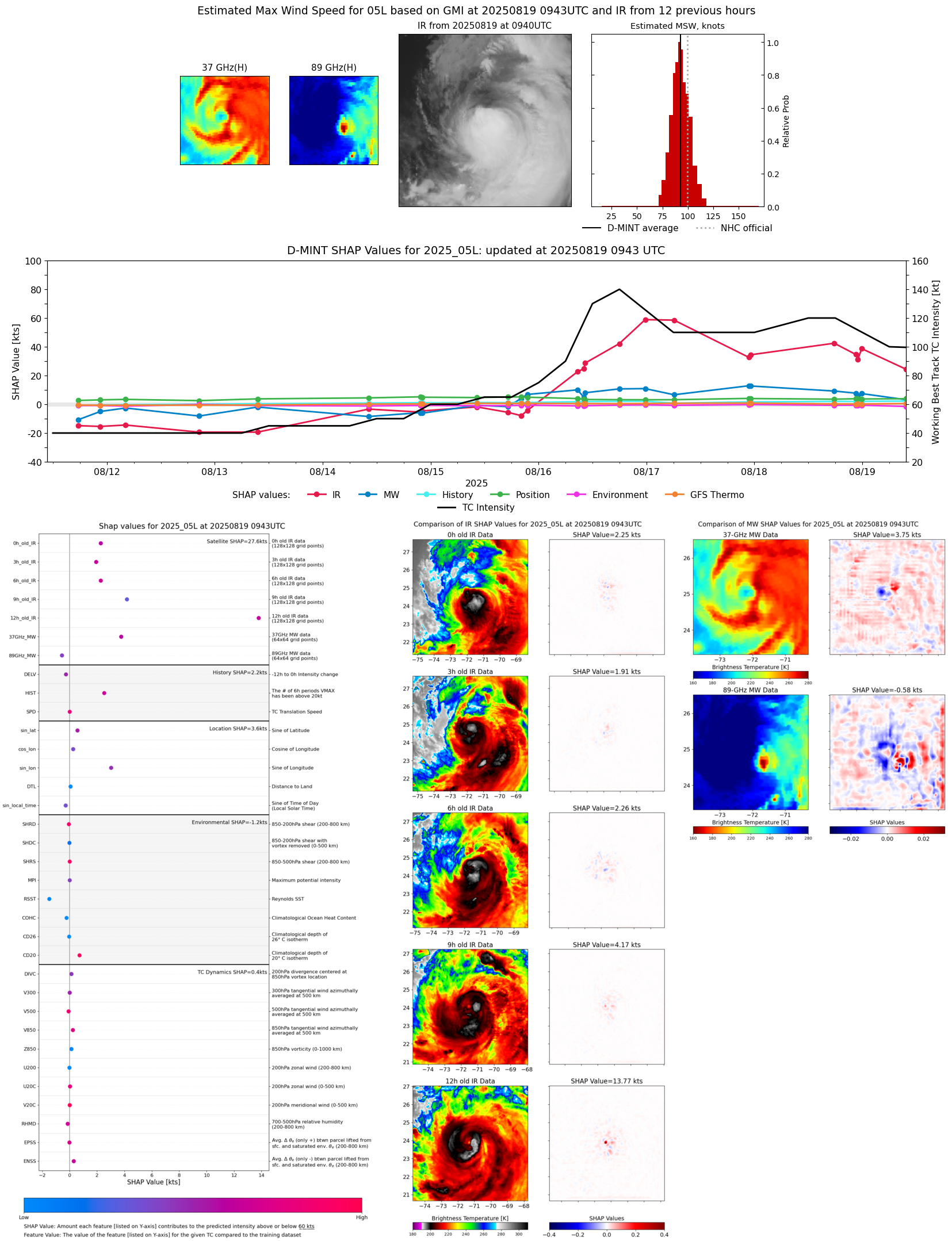 |
| 20250819 | 0251 UTC | AWS | 955 hPa | 102 kts | 96 kts | 109 kts | 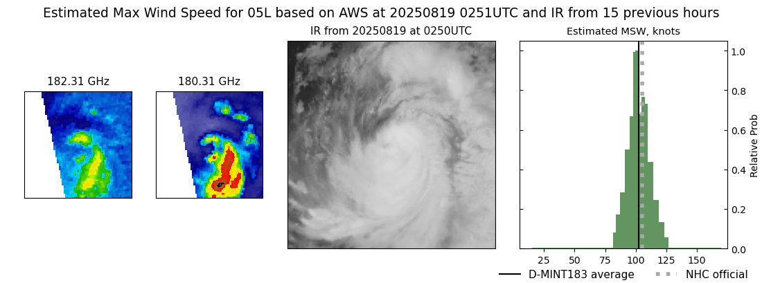 |
| 20250819 | 0201 UTC | TROPICS05 | 953 hPa | 96 kts | 90 kts | 102 kts | 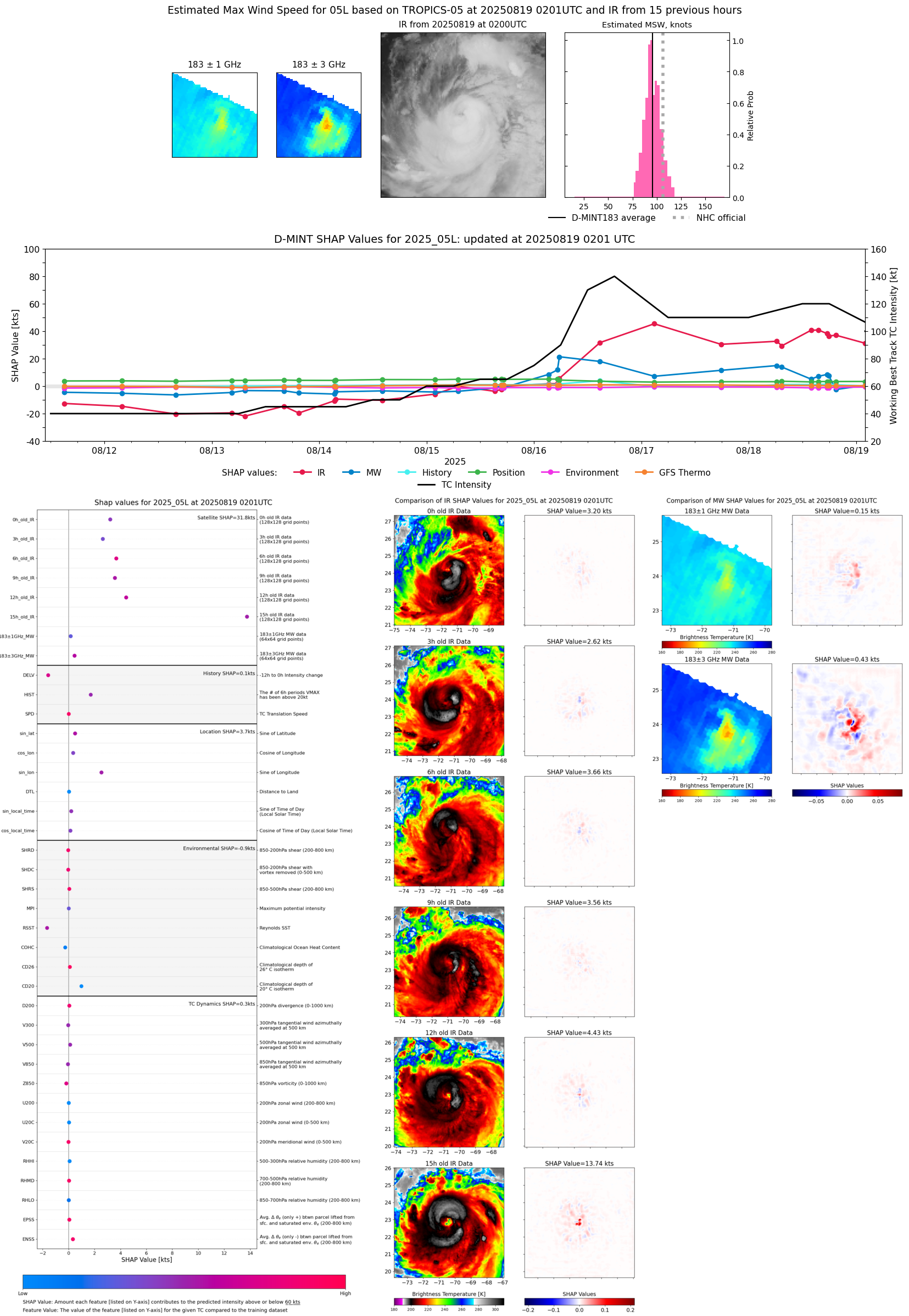 |
| 20250818 | 2353 UTC | GMI | 950 hPa | 111 kts | 105 kts | 118 kts | 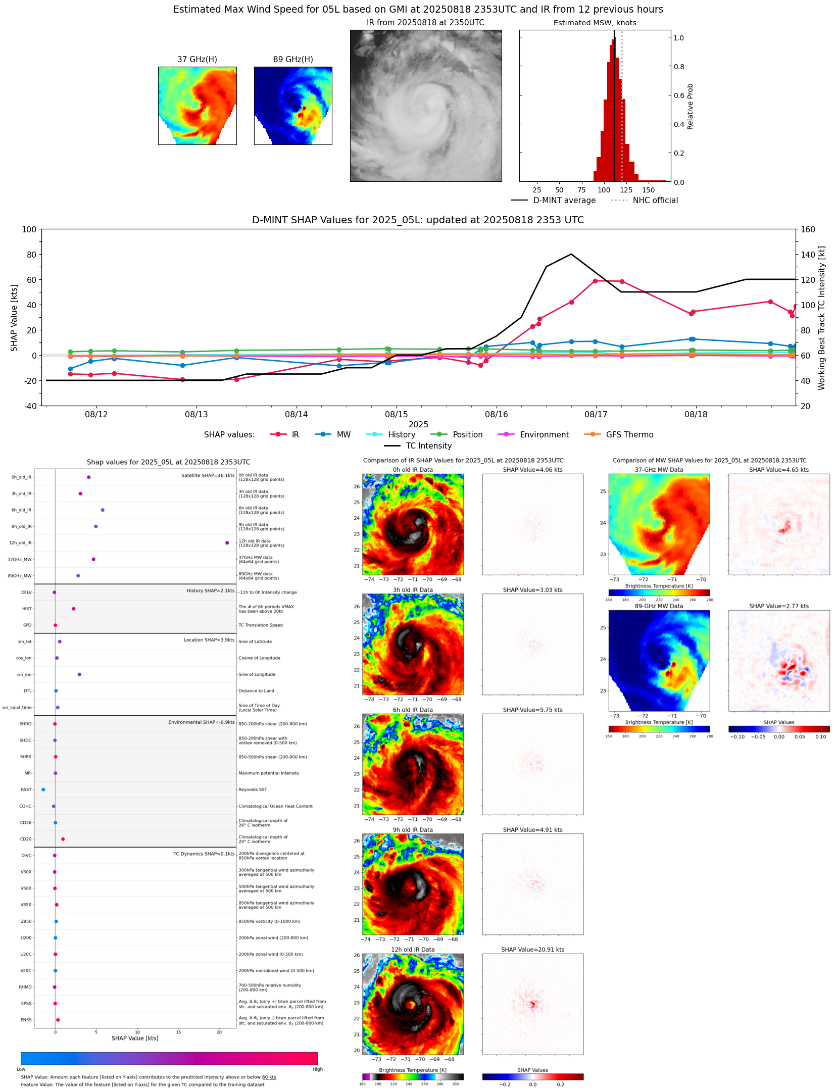 |
| 20250818 | 2301 UTC | SSMISF16 | 953 hPa | 103 kts | 96 kts | 110 kts | 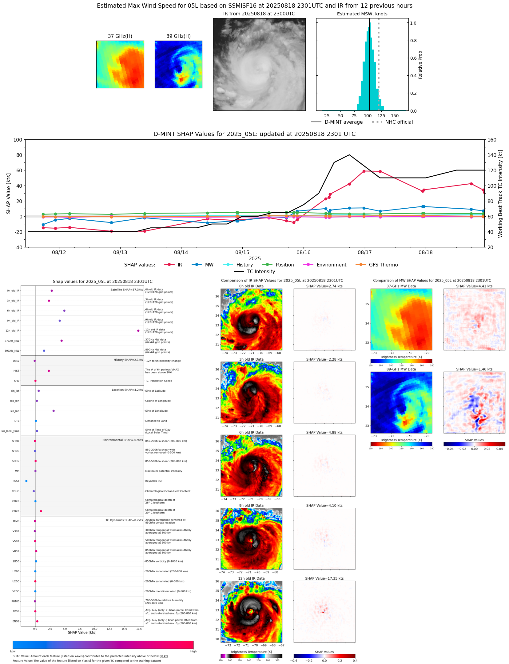 |
| 20250818 | 2232 UTC | SSMISF17 | 947 hPa | 108 kts | 101 kts | 115 kts |  |
| 20250818 | 2232 UTC | SSMISF17 | 950 hPa | 107 kts | 100 kts | 113 kts | 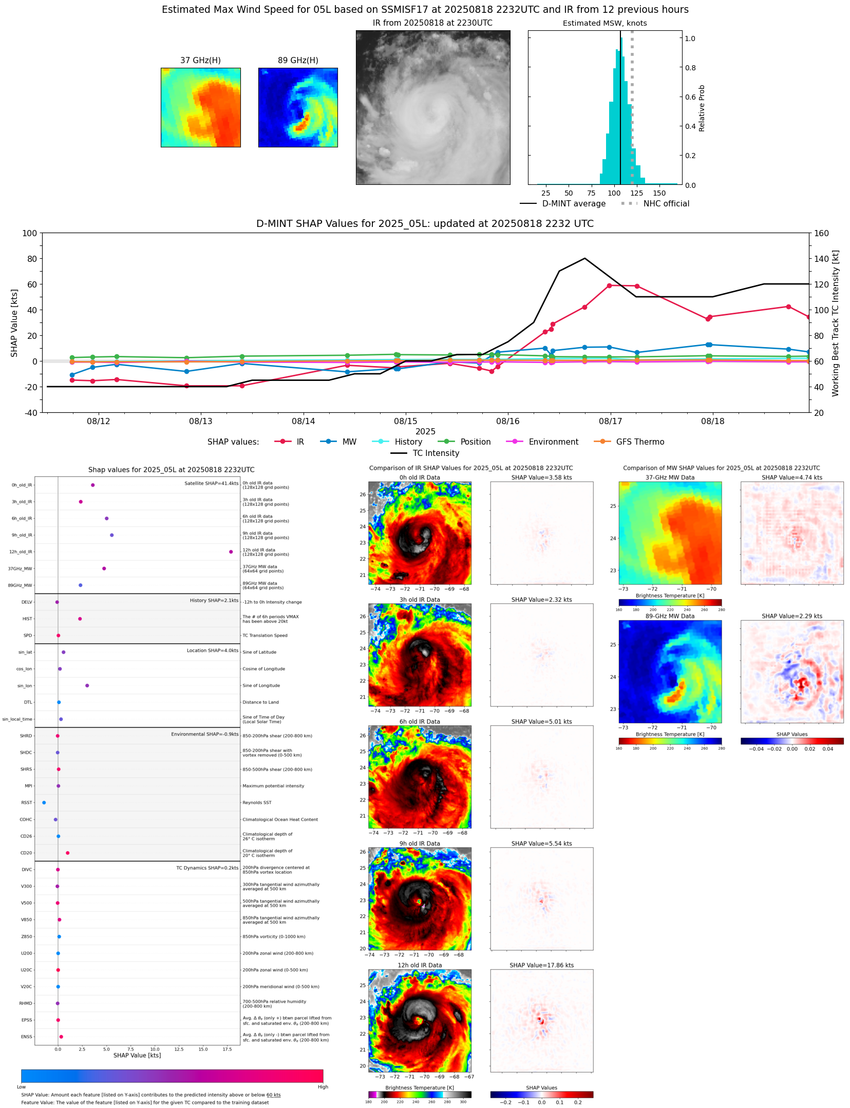 |
| 20250818 | 1929 UTC | TROPICS05 | 959 hPa | 99 kts | 94 kts | 104 kts | 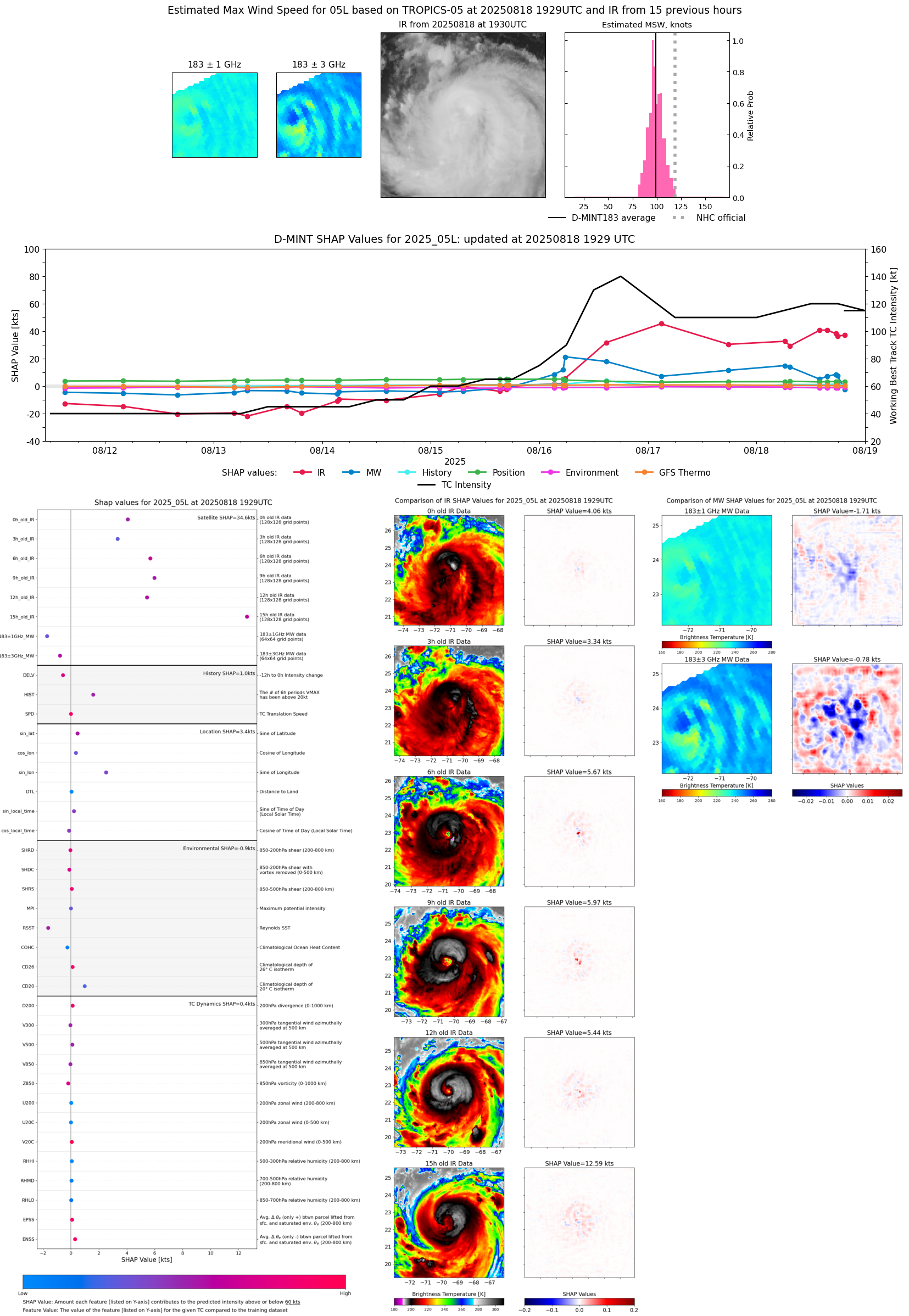 |
| 20250818 | 1757 UTC | ATMS-NPP | 941 hPa | 109 kts | 104 kts | 114 kts | 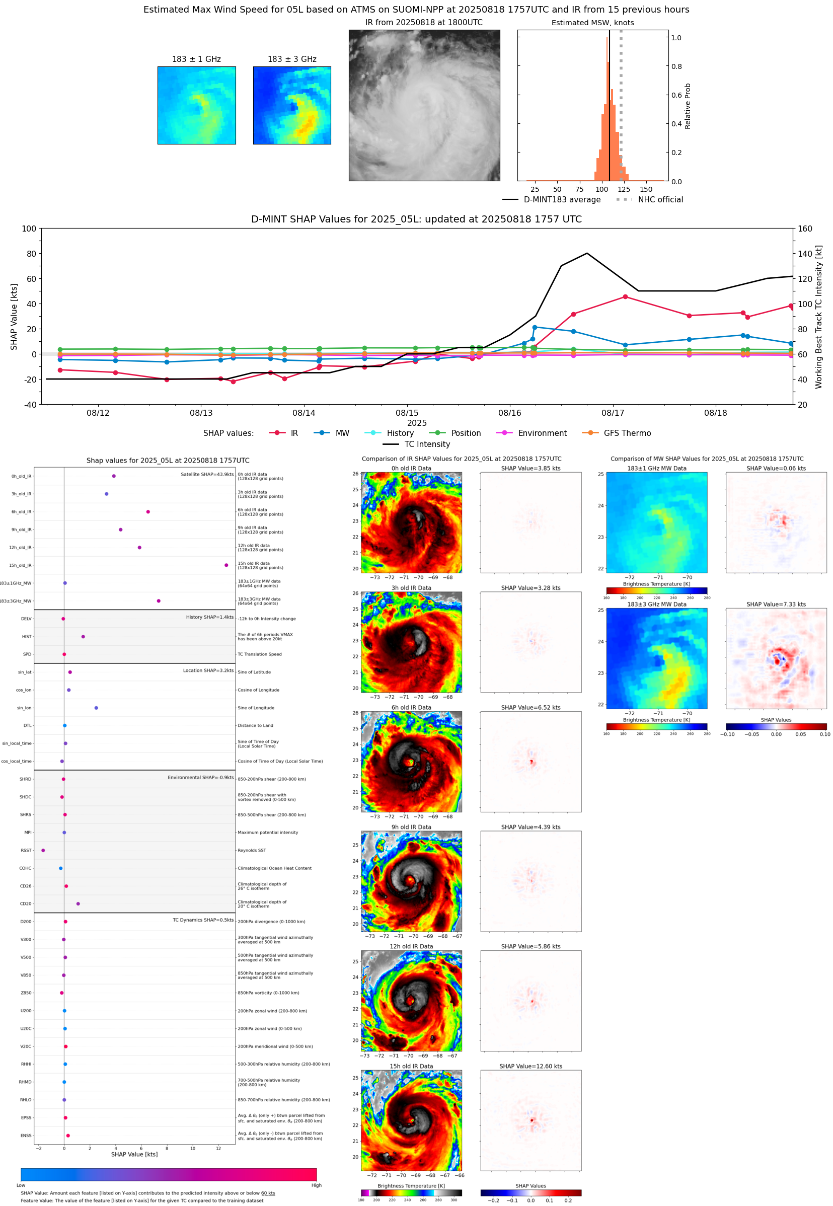 |
| 20250818 | 1746 UTC | AMSR2 | 946 hPa | 117 kts | 110 kts | 124 kts |  |
| 20250818 | 1731 UTC | ATMS-N21 | 942 hPa | 112 kts | 106 kts | 117 kts | 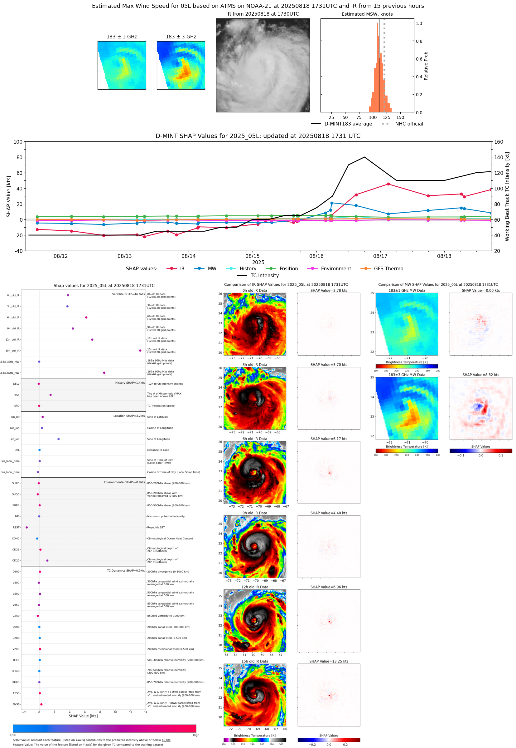 |
| 20250818 | 1534 UTC | TMS02 | 948 hPa | 112 kts | 107 kts | 118 kts | 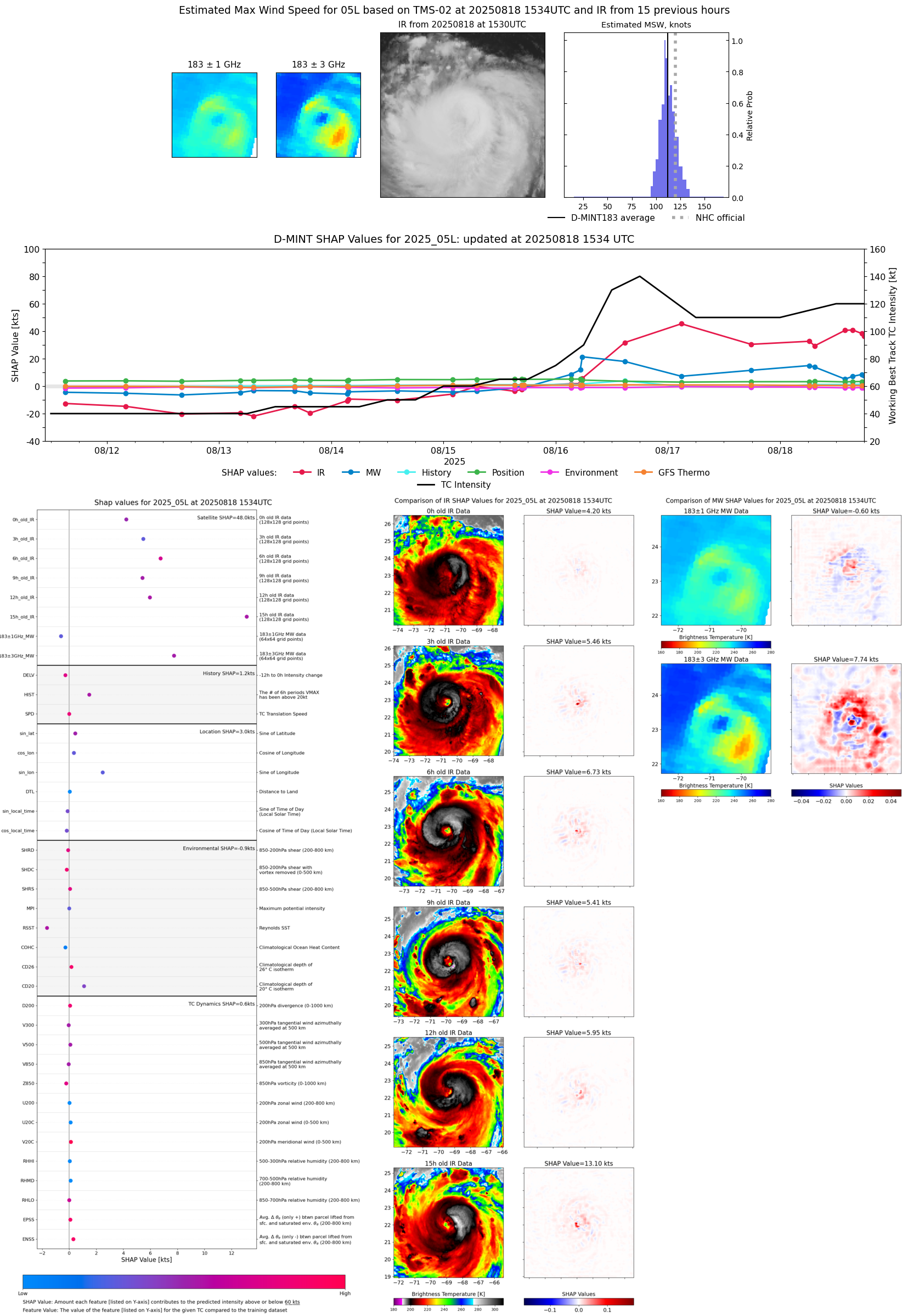 |
| 20250818 | 1356 UTC | TROPICS03 | 949 hPa | 110 kts | 106 kts | 114 kts |  |
| 20250818 | 0725 UTC | TROPICS03 | 948 hPa | 108 kts | 103 kts | 114 kts | 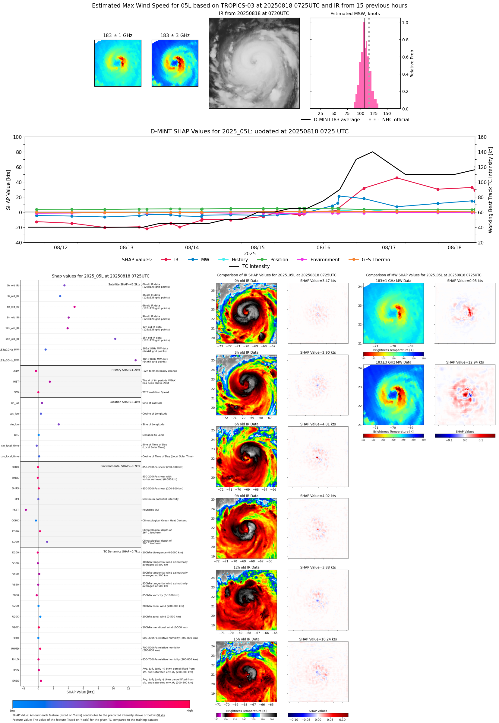 |
| 20250818 | 0651 UTC | AMSR2 | 945 hPa | 115 kts | 110 kts | 121 kts | 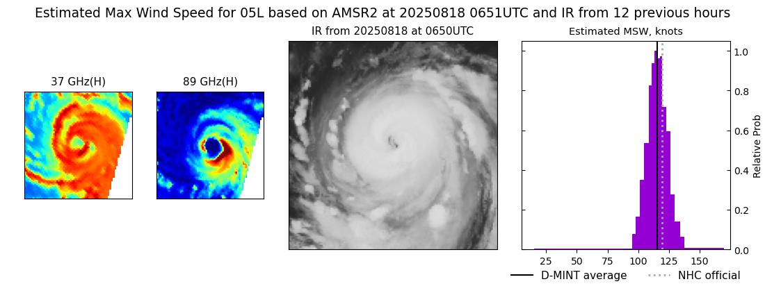 |
| 20250818 | 0618 UTC | ATMS-N21 | 941 hPa | 112 kts | 107 kts | 118 kts | 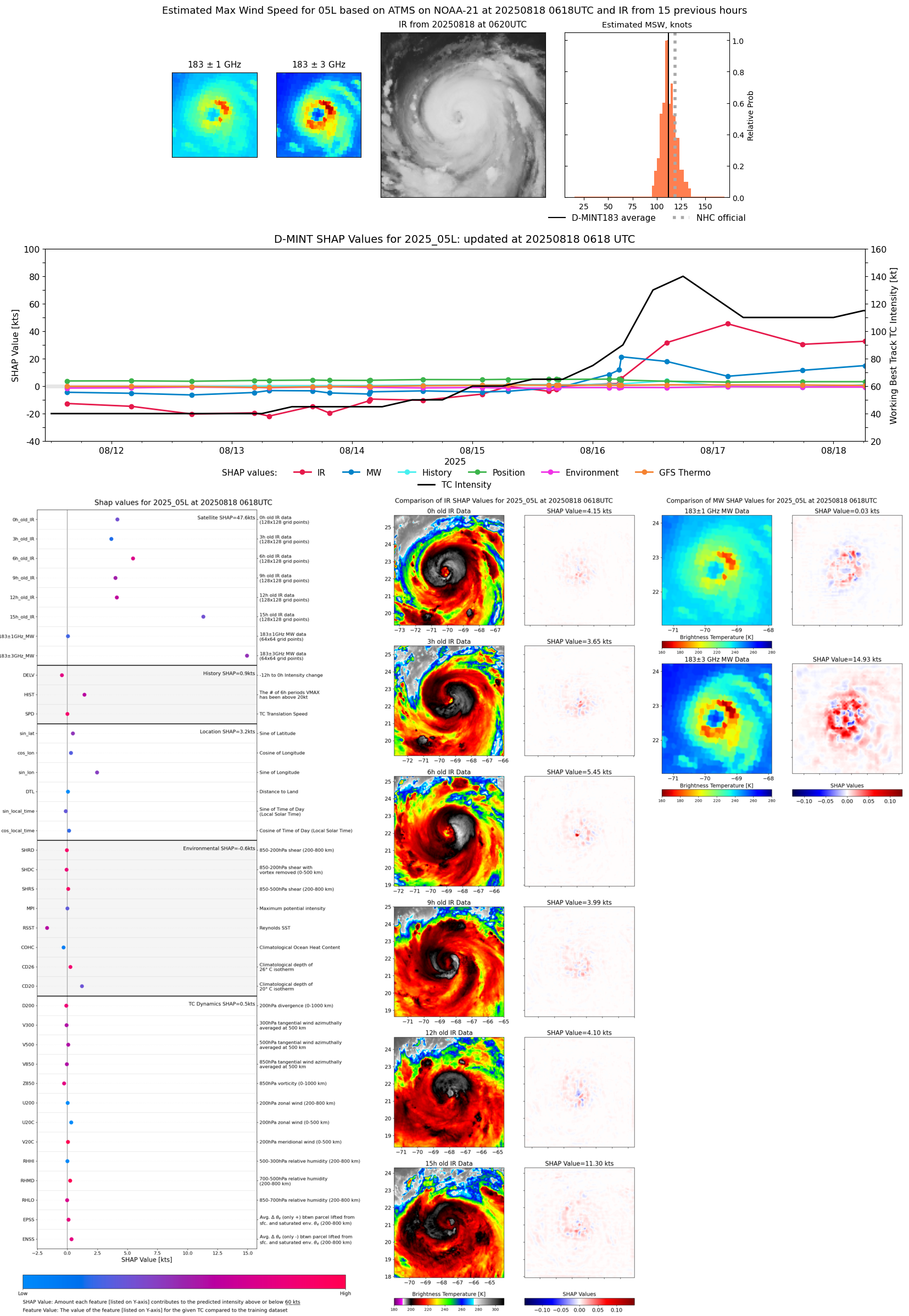 |
| 20250817 | 2314 UTC | SSMISF16 | 951 hPa | 113 kts | 106 kts | 121 kts | 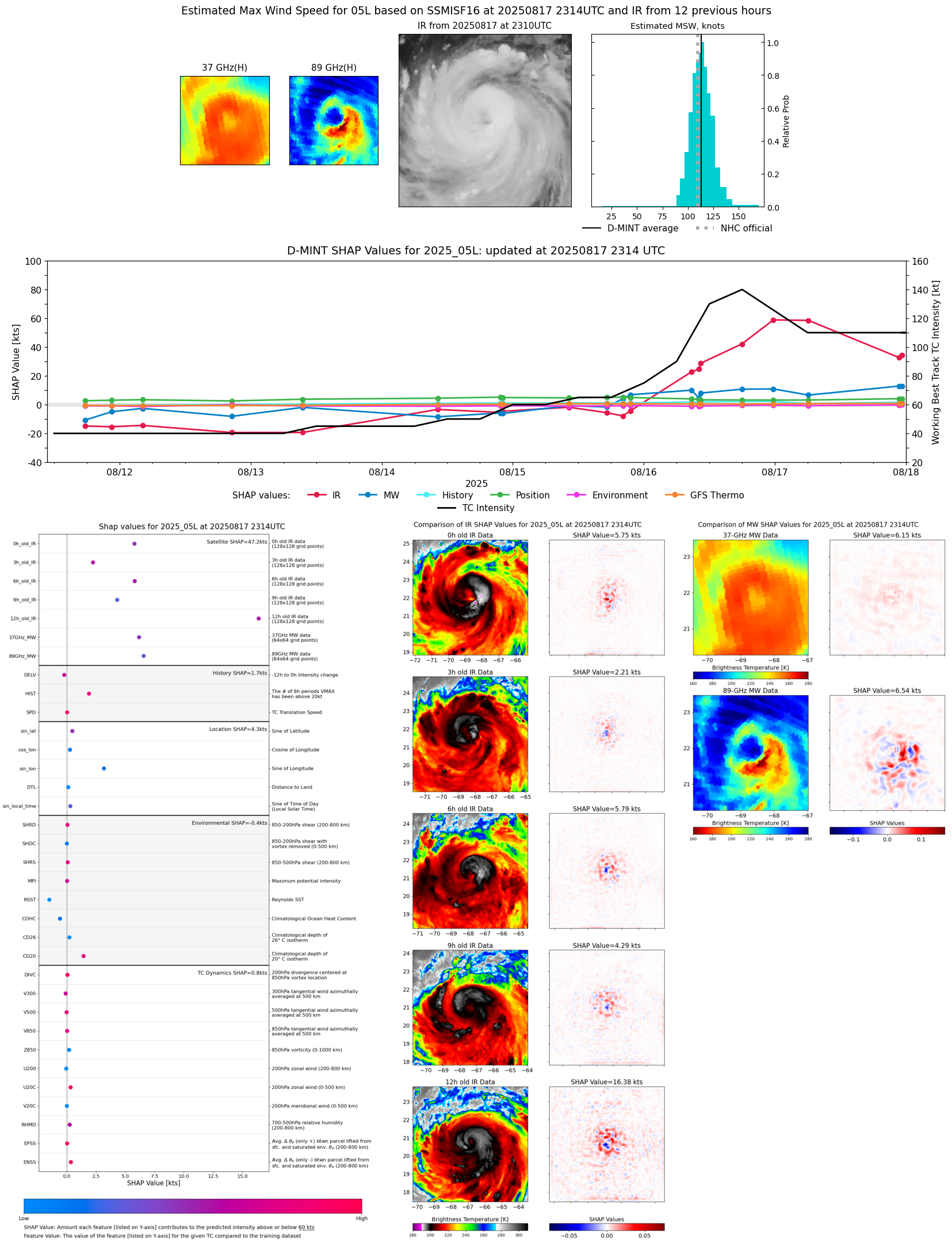 |
| 20250817 | 2246 UTC | SSMISF17 | 950 hPa | 112 kts | 105 kts | 119 kts |  |
| 20250817 | 1749 UTC | ATMS-N21 | 946 hPa | 105 kts | 100 kts | 112 kts |  |
| 20250817 | 0608 UTC | AMSR2 | 941 hPa | 129 kts | 121 kts | 136 kts | 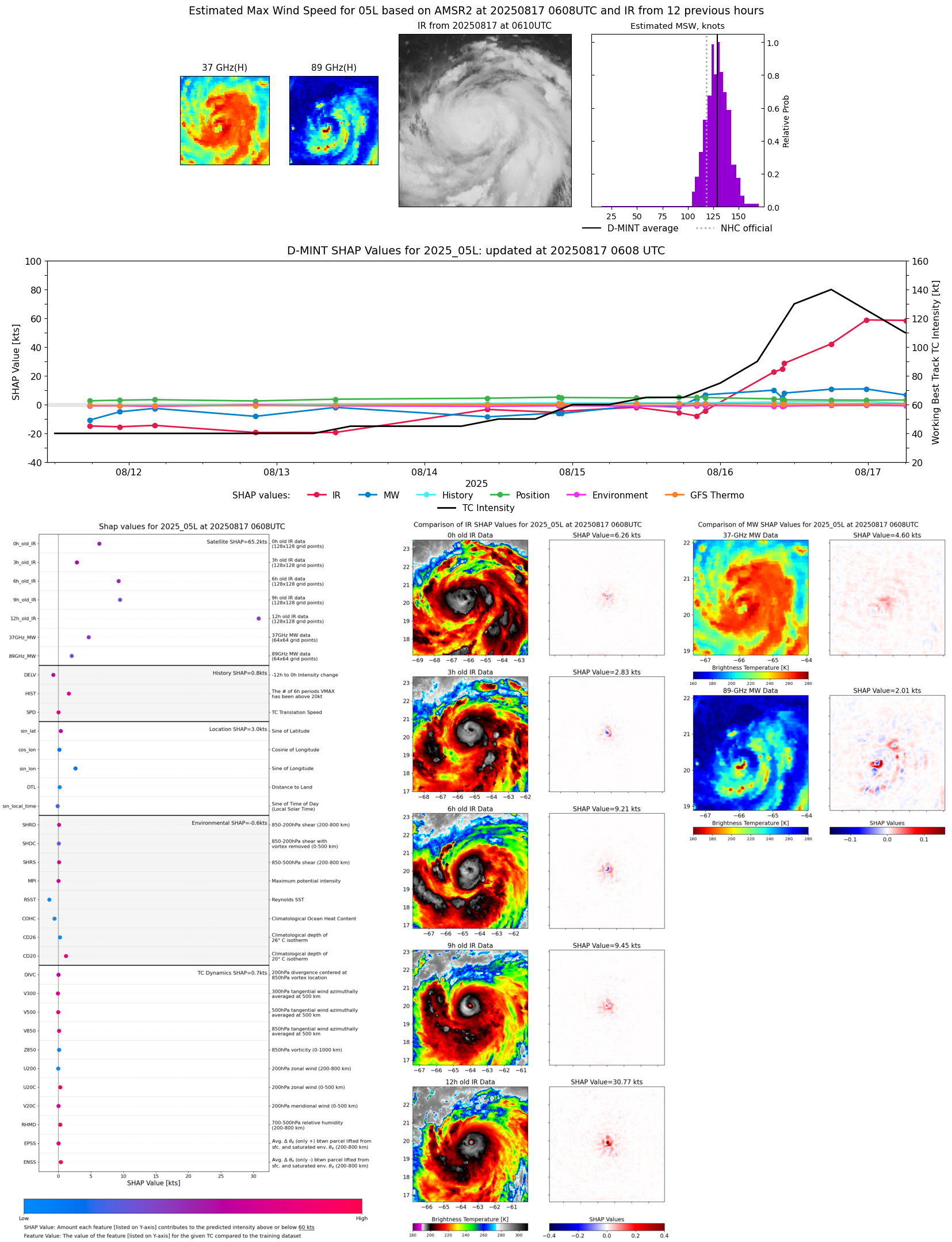 |
| 20250817 | 0254 UTC | TMS02 | 942 hPa | 116 kts | 111 kts | 122 kts | 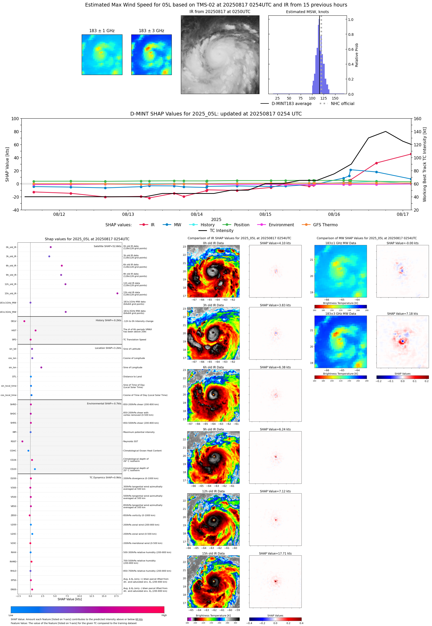 |
| 20250817 | 0228 UTC | AWS | 934 hPa | 124 kts | 120 kts | 129 kts | 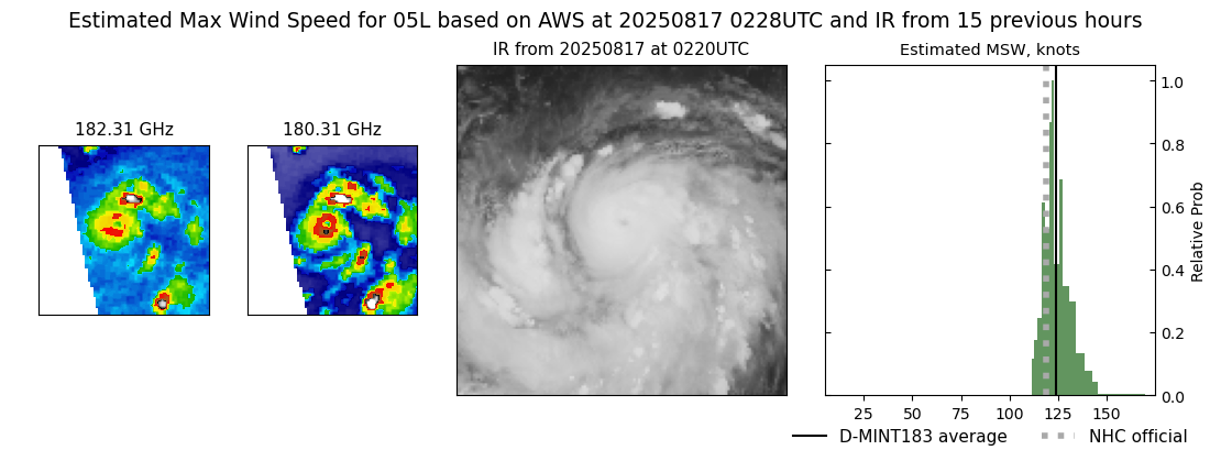 |
| 20250816 | 2343 UTC | GMI | 936 hPa | 135 kts | 127 kts | 143 kts |  |
| 20250816 | 1947 UTC | TROPICS05 | 948 hPa | 114 kts | 108 kts | 121 kts |  |
| 20250816 | 1758 UTC | AMSR2 | 947 hPa | 118 kts | 110 kts | 125 kts |  |
| 20250816 | 1447 UTC | TMS02 | 952 hPa | 117 kts | 112 kts | 124 kts |  |
| 20250816 | 1023 UTC | GMI | 952 hPa | 101 kts | 94 kts | 108 kts | 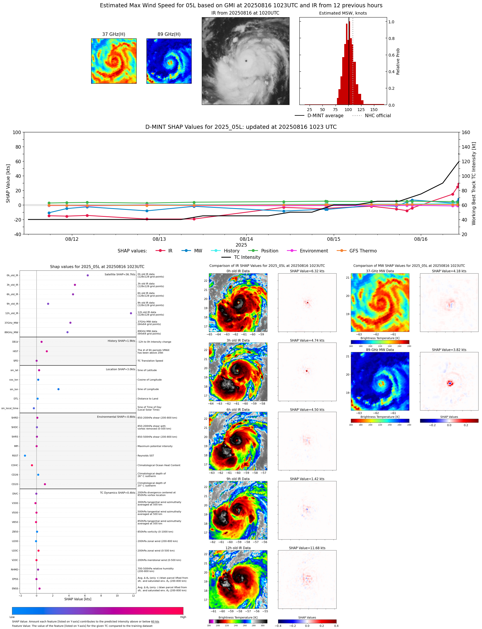 |
| 20250816 | 1004 UTC | SSMISF17 | 964 hPa | 95 kts | 88 kts | 102 kts |  |
| 20250816 | 0841 UTC | SSMISF18 | 959 hPa | 98 kts | 90 kts | 105 kts | 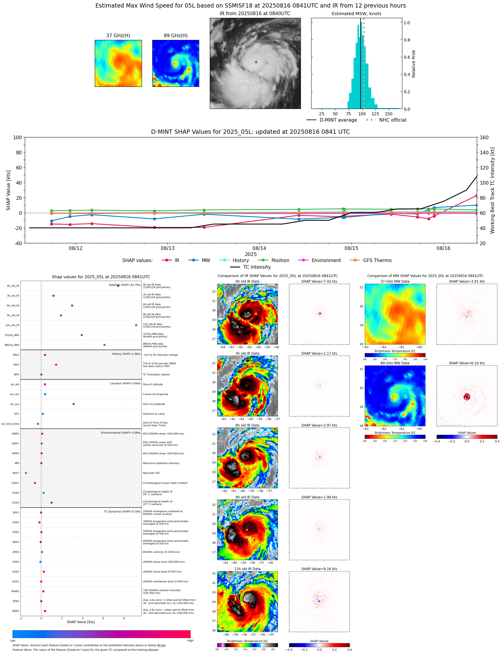 |
| 20250816 | 0542 UTC | ATMS-NPP | 962 hPa | 93 kts | 87 kts | 100 kts | 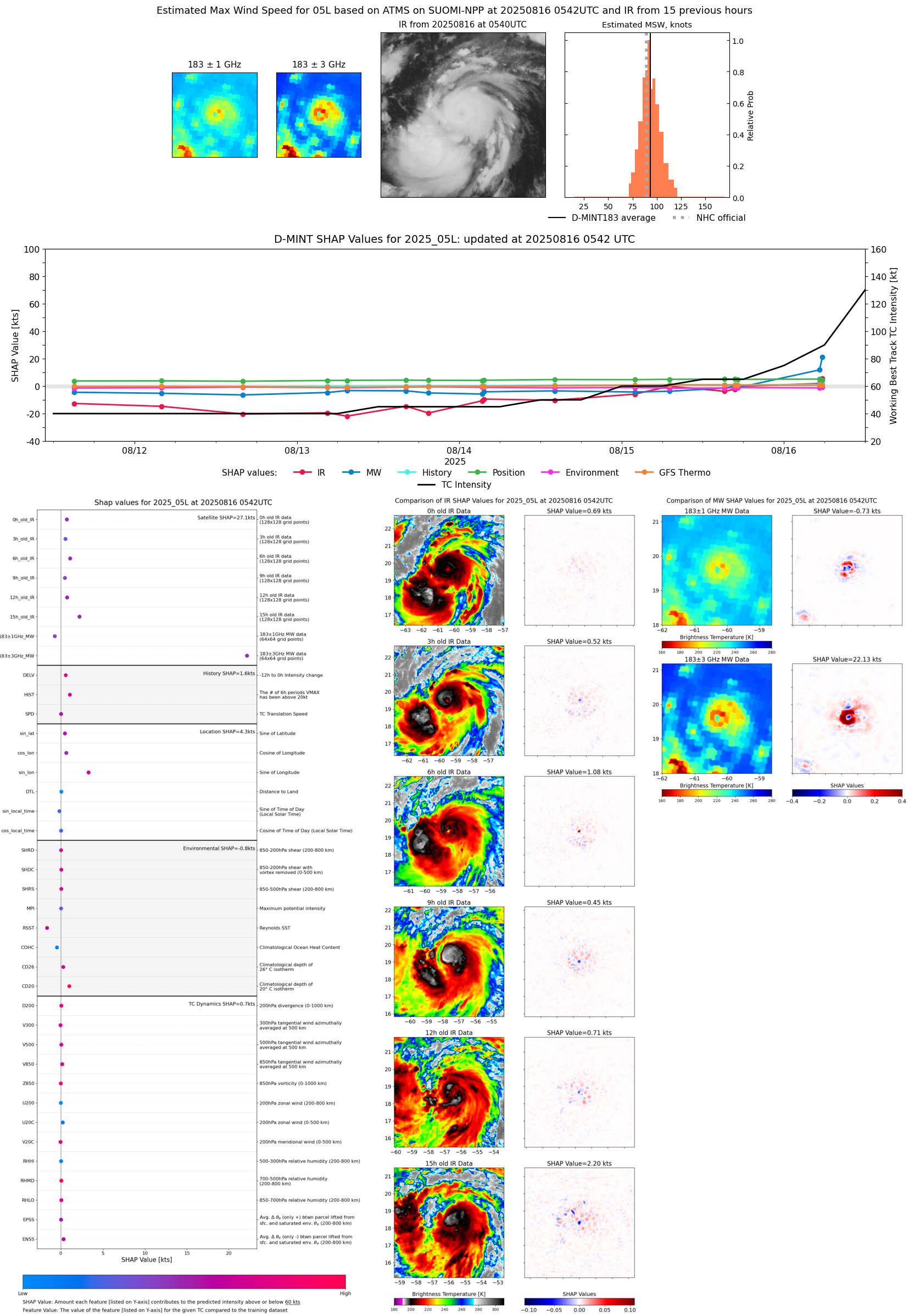 |
| 20250816 | 0525 UTC | AMSR2 | 974 hPa | 85 kts | 78 kts | 93 kts | 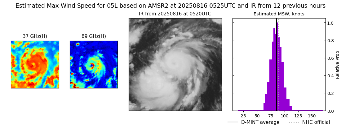 |
| 20250816 | 0516 UTC | ATMS-N21 | 979 hPa | 80 kts | 73 kts | 87 kts | 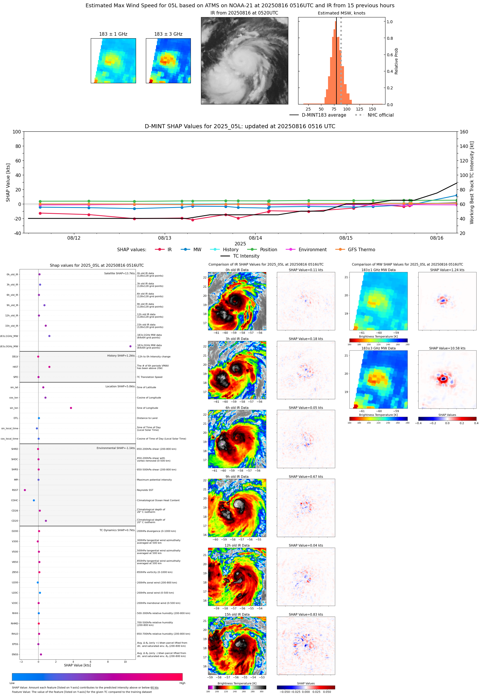 |
| 20250816 | 0318 UTC | TROPICS05 | 977 hPa | 77 kts | 70 kts | 84 kts | 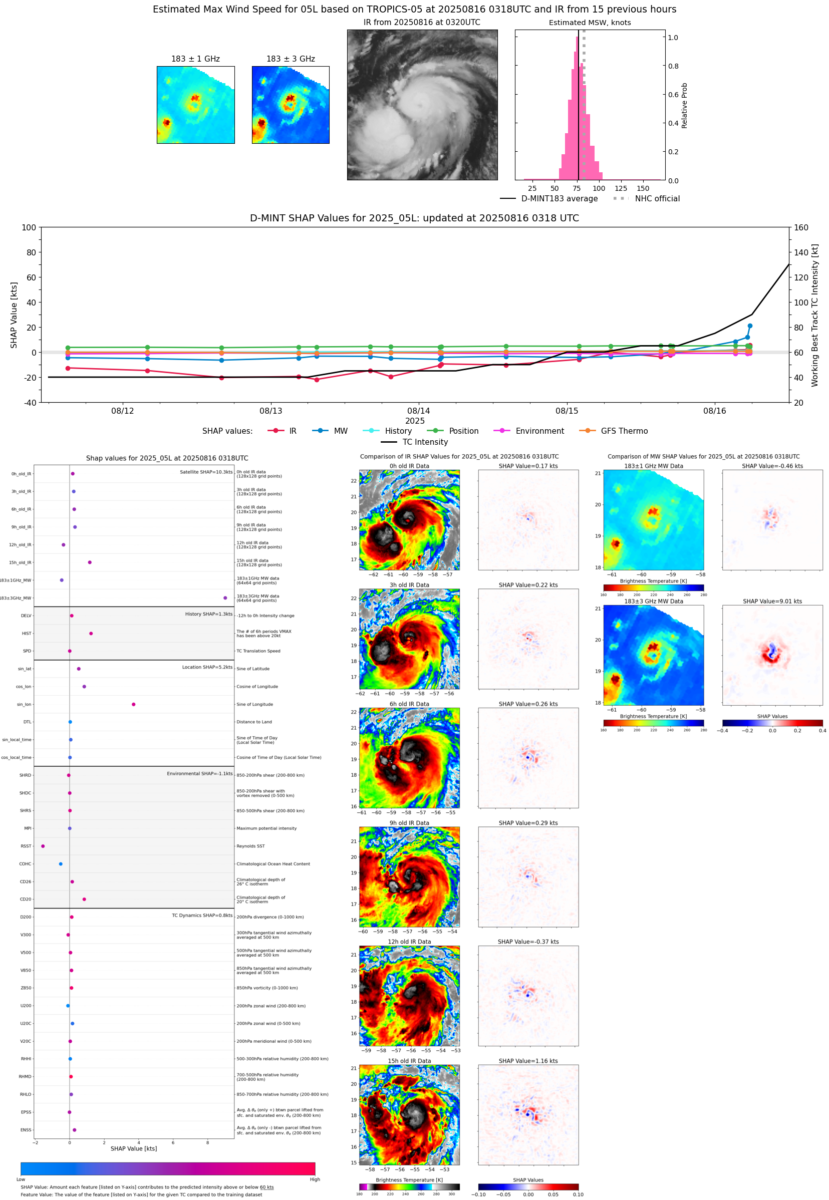 |
| 20250816 | 0217 UTC | AWS | 978 hPa | 78 kts | 72 kts | 85 kts | 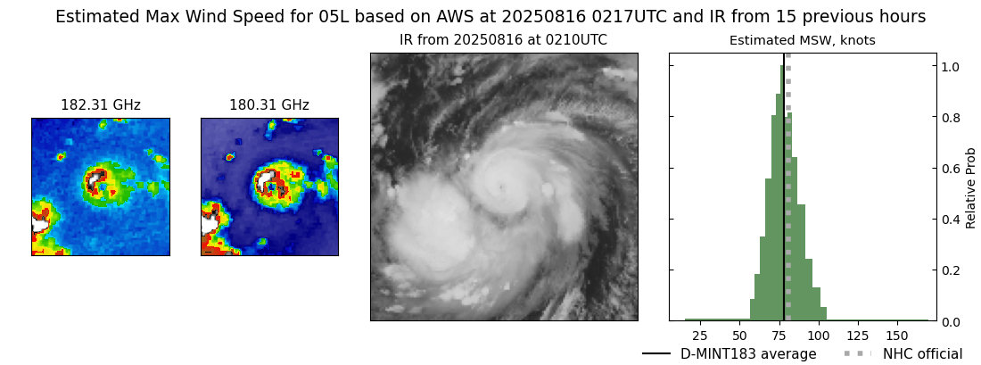 |
| 20250815 | 2132 UTC | SSMISF17 | 984 hPa | 69 kts | 62 kts | 76 kts |  |
| 20250815 | 2009 UTC | SSMISF18 | 991 hPa | 62 kts | 56 kts | 69 kts |  |
| 20250815 | 1714 UTC | AMSR2 | 997 hPa | 59 kts | 53 kts | 64 kts |  |
| 20250815 | 1712 UTC | ATMS-NPP | 987 hPa | 65 kts | 59 kts | 70 kts | 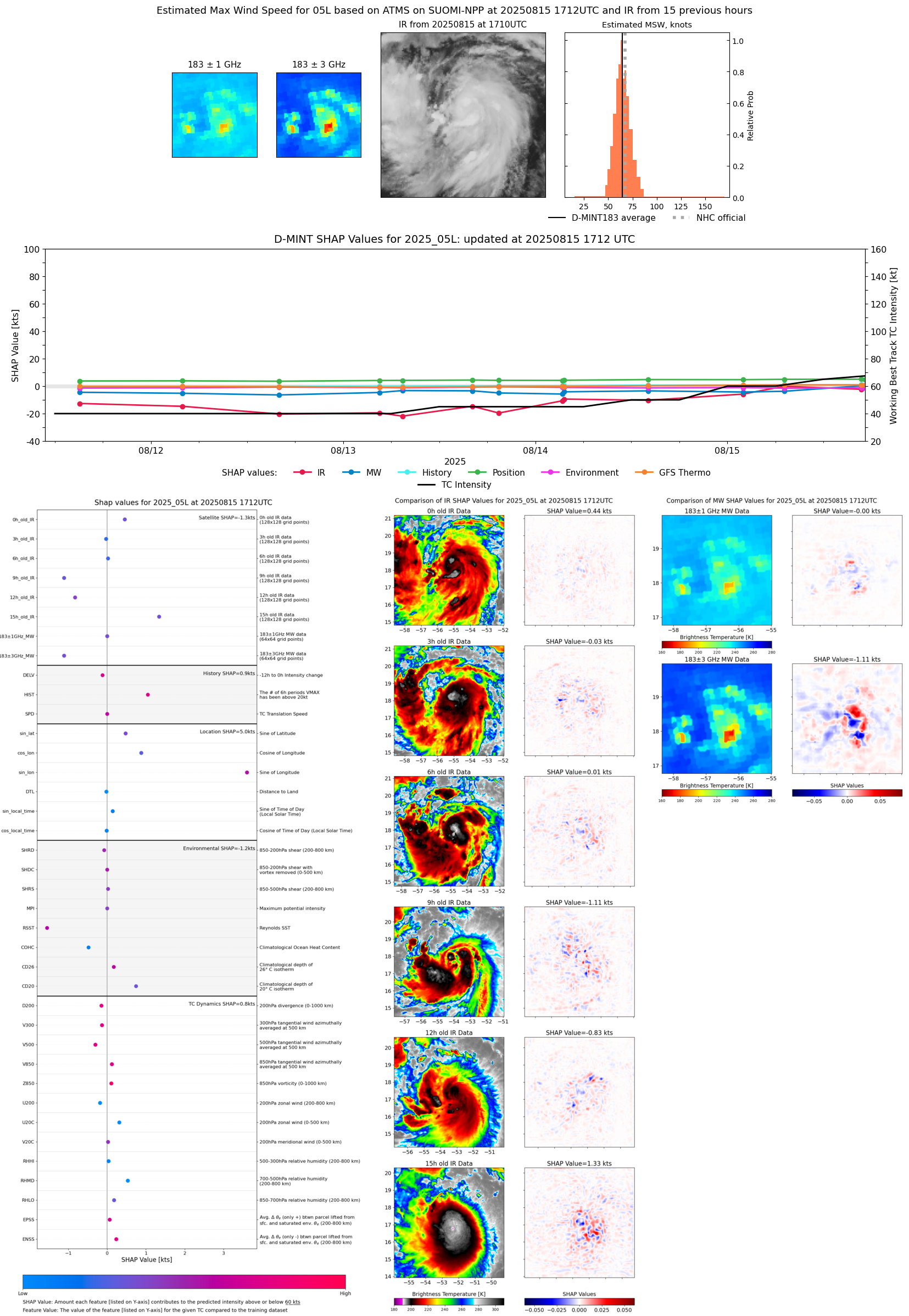 |
| 20250815 | 1645 UTC | ATMS-N21 | 985 hPa | 64 kts | 59 kts | 70 kts |  |
| 20250815 | 1515 UTC | TROPICS03 | 995 hPa | 61 kts | 55 kts | 66 kts | 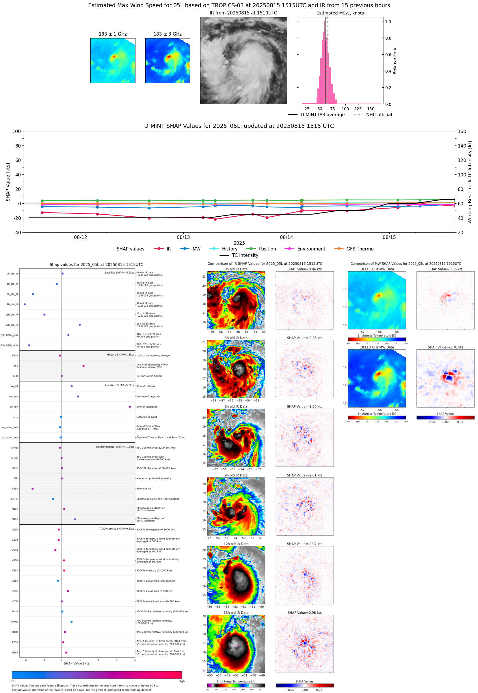 |
| 20250815 | 1045 UTC | SSMISF16 | 994 hPa | 65 kts | 59 kts | 71 kts | 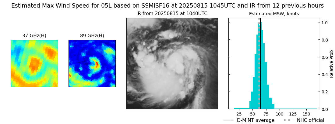 |
| 20250815 | 1019 UTC | SSMISF17 | 993 hPa | 63 kts | 57 kts | 69 kts | 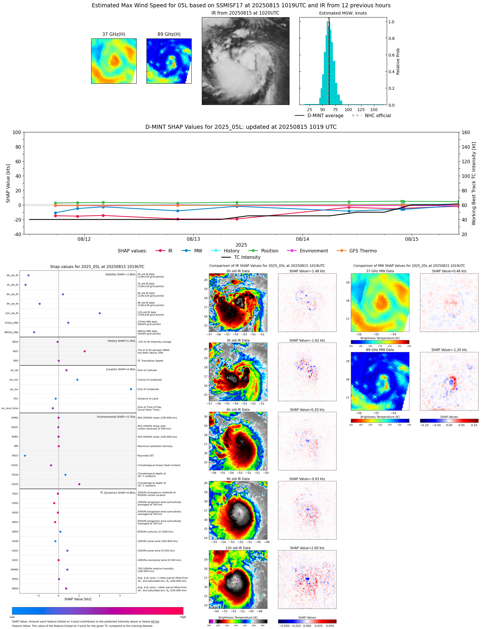 |
| 20250815 | 0705 UTC | TROPICS03 | 992 hPa | 62 kts | 56 kts | 68 kts |  |
| 20250815 | 0157 UTC | TMS02 | 998 hPa | 55 kts | 50 kts | 62 kts | 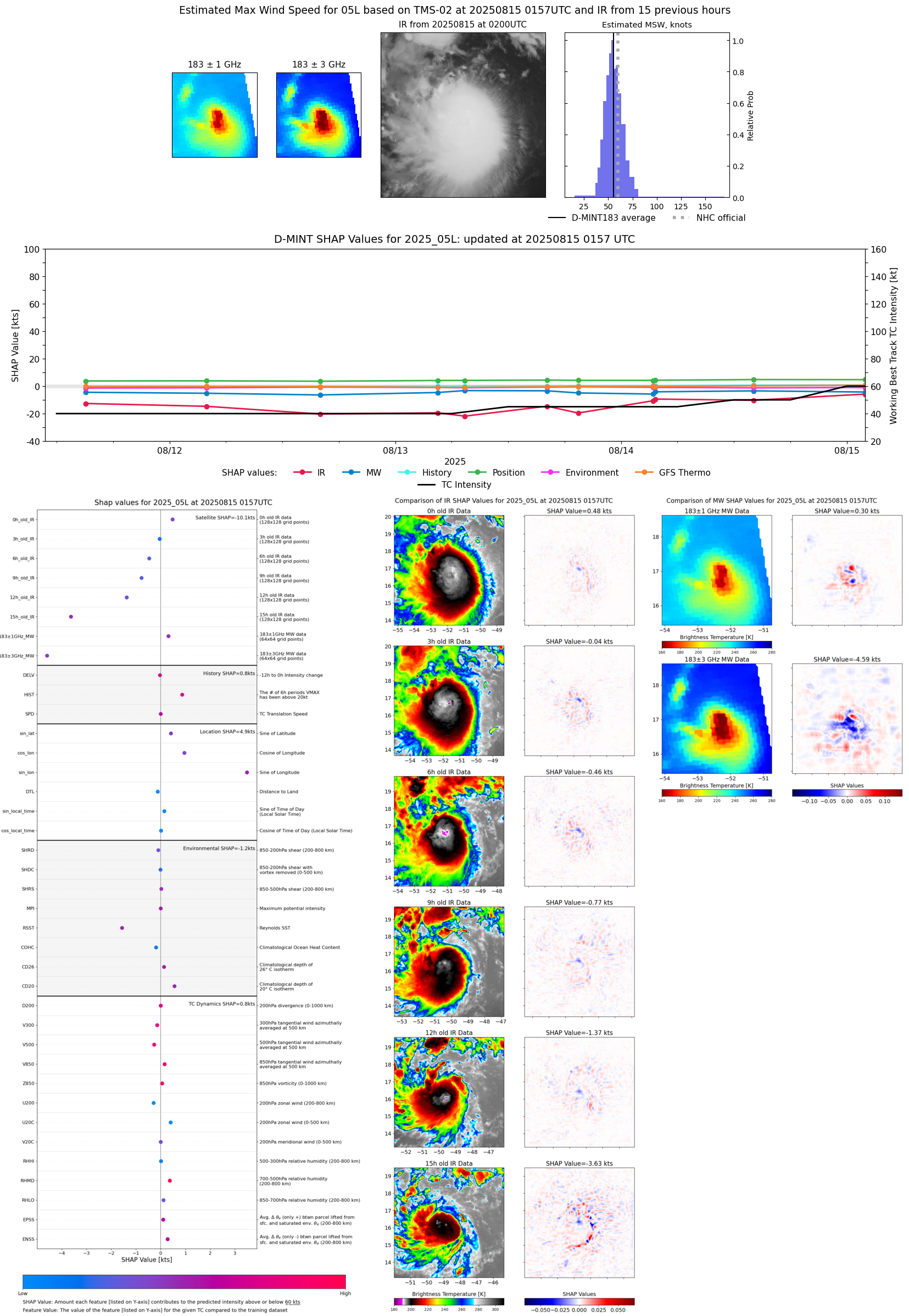 |
| 20250814 | 2212 UTC | SSMISF16 | 1005 hPa | 55 kts | 49 kts | 61 kts | 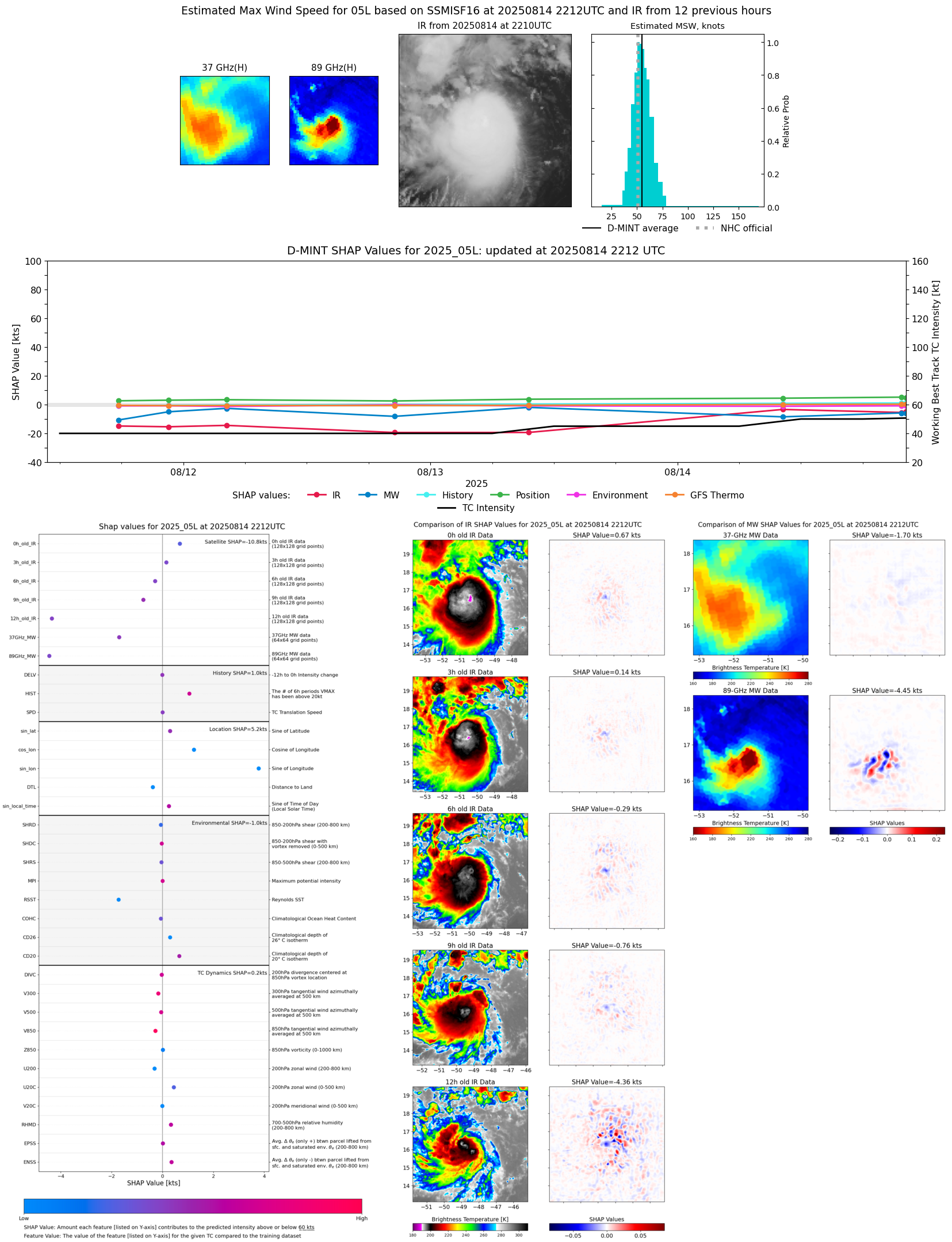 |
| 20250814 | 2146 UTC | SSMISF17 | 1005 hPa | 55 kts | 49 kts | 61 kts | 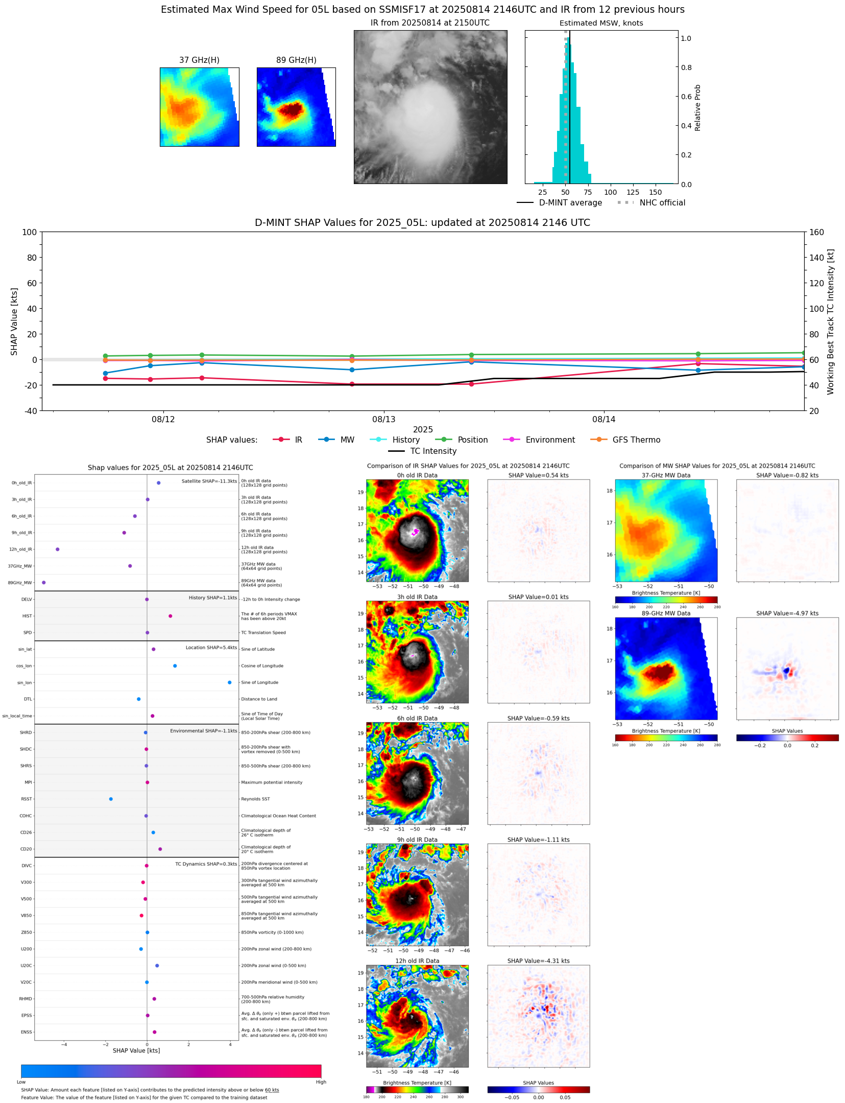 |
| 20250814 | 1630 UTC | AMSR2 | 1001 hPa | 51 kts | 45 kts | 56 kts |  |
| 20250814 | 1405 UTC | TMS02 | 999 hPa | 51 kts | 46 kts | 57 kts | 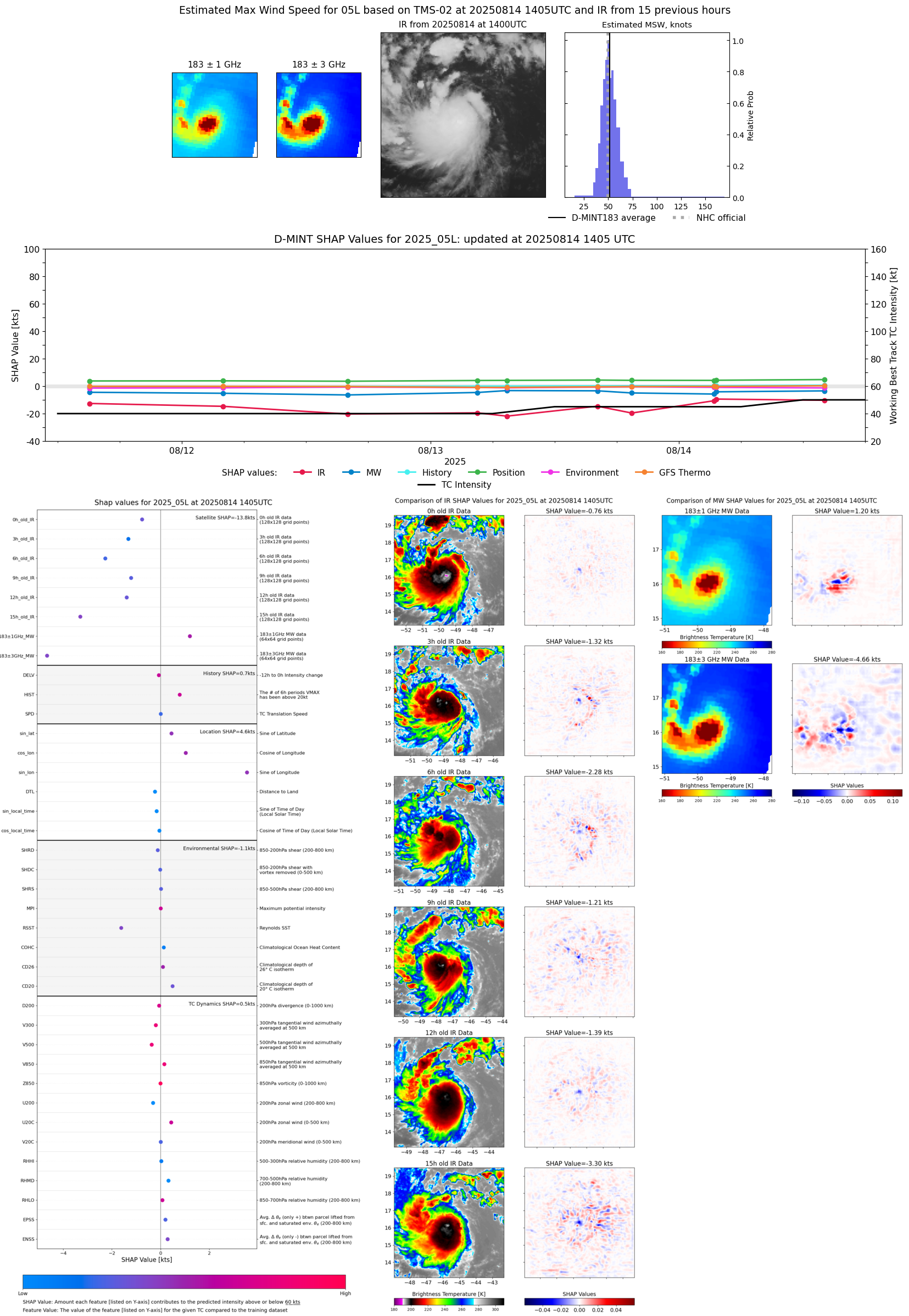 |
| 20250814 | 1352 UTC | AWS | 997 hPa | 51 kts | 46 kts | 57 kts | 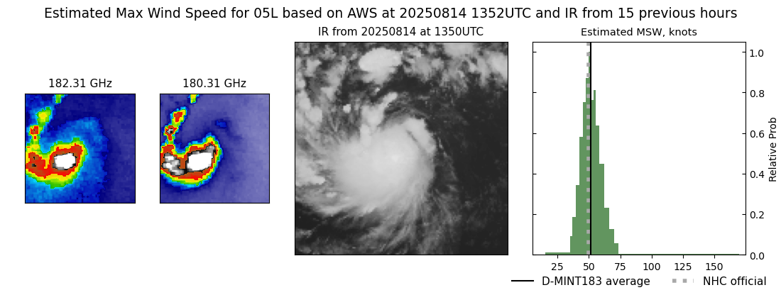 |
| 20250814 | 1013 UTC | GMI | 994 hPa | 52 kts | 47 kts | 58 kts | 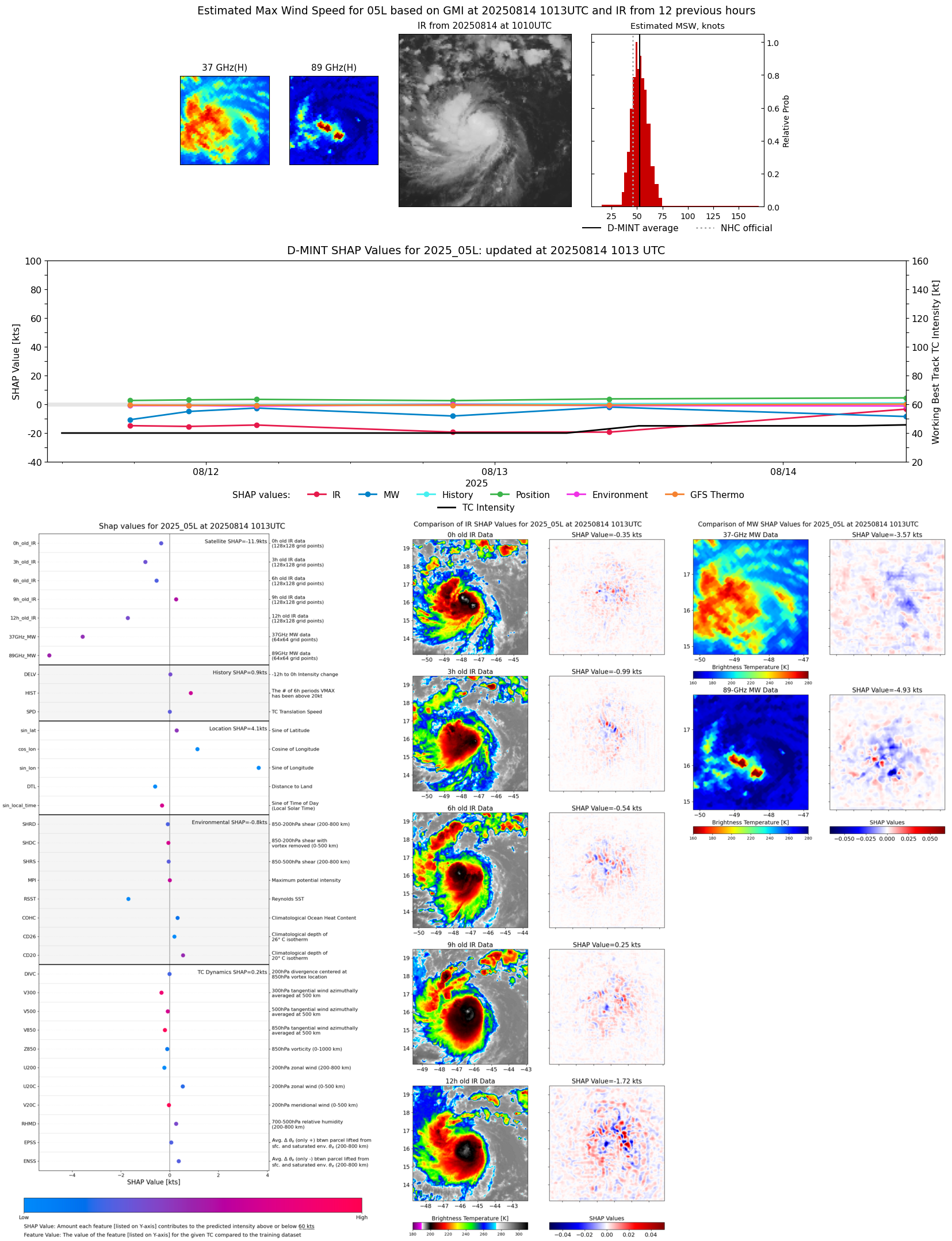 |
| 20250814 | 0338 UTC | TROPICS05 | 1000 hPa | 50 kts | 45 kts | 55 kts |  |
| 20250814 | 0323 UTC | TMS03 | 1001 hPa | 47 kts | 43 kts | 52 kts | 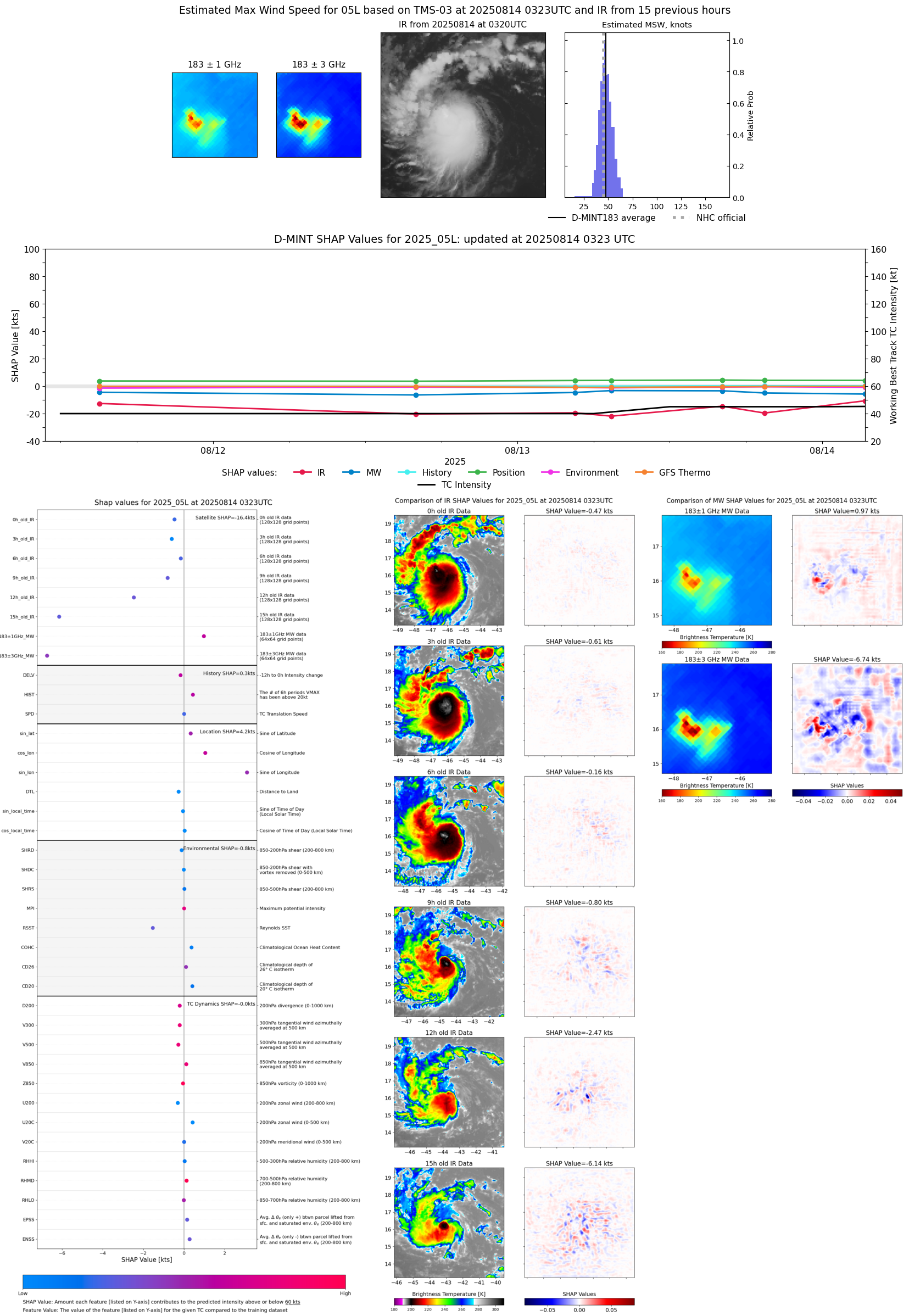 |
| 20250813 | 1927 UTC | TROPICS05 | 1002 hPa | 40 kts | 36 kts | 44 kts | 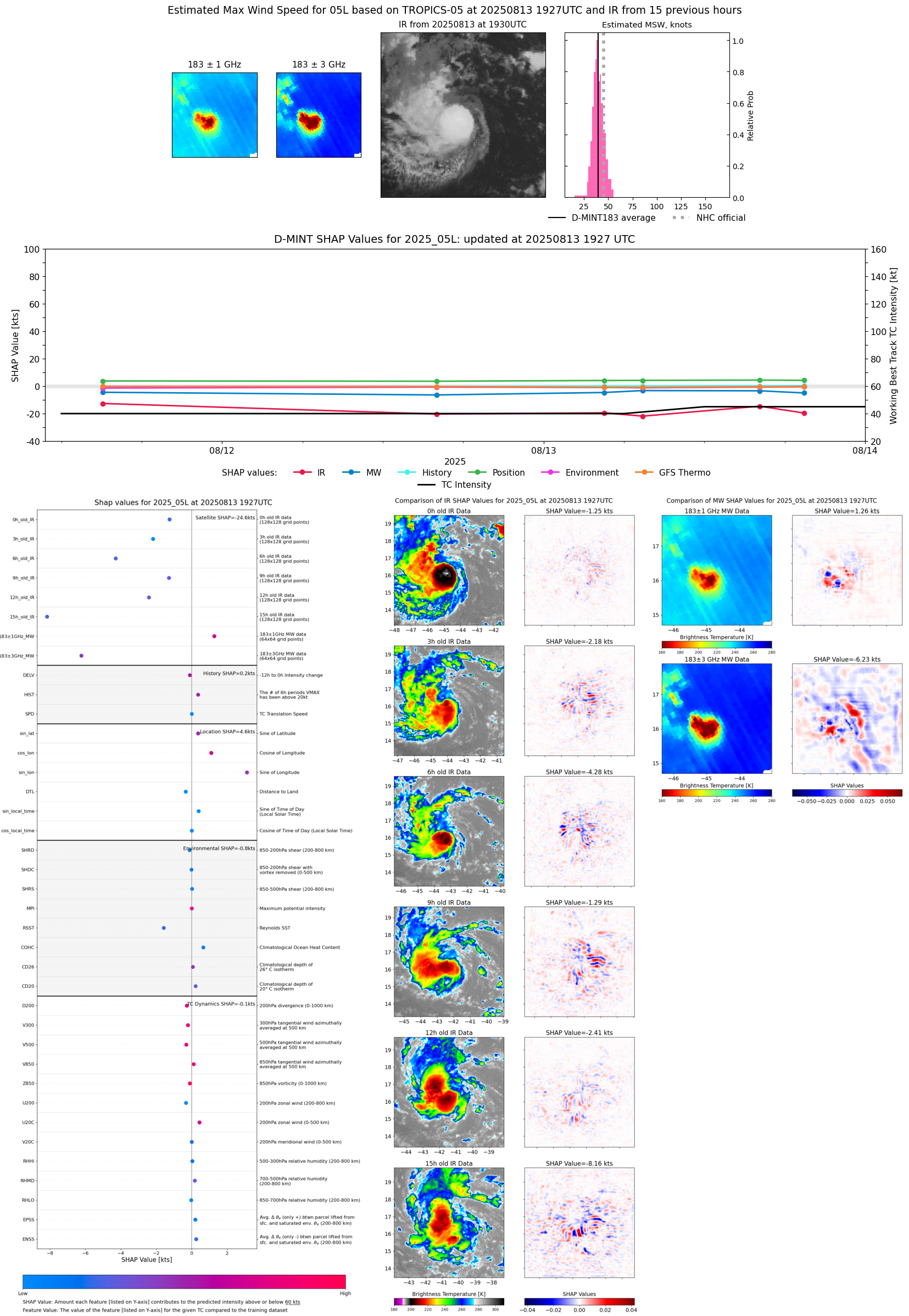 |
| 20250813 | 1608 UTC | ATMS-NPP | 996 hPa | 46 kts | 42 kts | 51 kts |  |
| 20250813 | 0932 UTC | SSMISF16 | 1003 hPa | 42 kts | 37 kts | 46 kts | 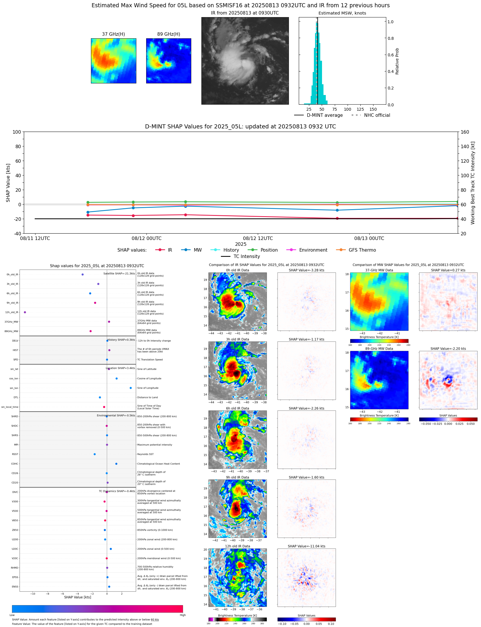 |
| 20250813 | 0906 UTC | SSMISF17 | 1004 hPa | 40 kts | 36 kts | 44 kts |  |
| 20250813 | 0724 UTC | TROPICS03 | 1003 hPa | 37 kts | 34 kts | 42 kts |  |
| 20250813 | 0432 UTC | ATMS-N21 | 1002 hPa | 39 kts | 34 kts | 43 kts | 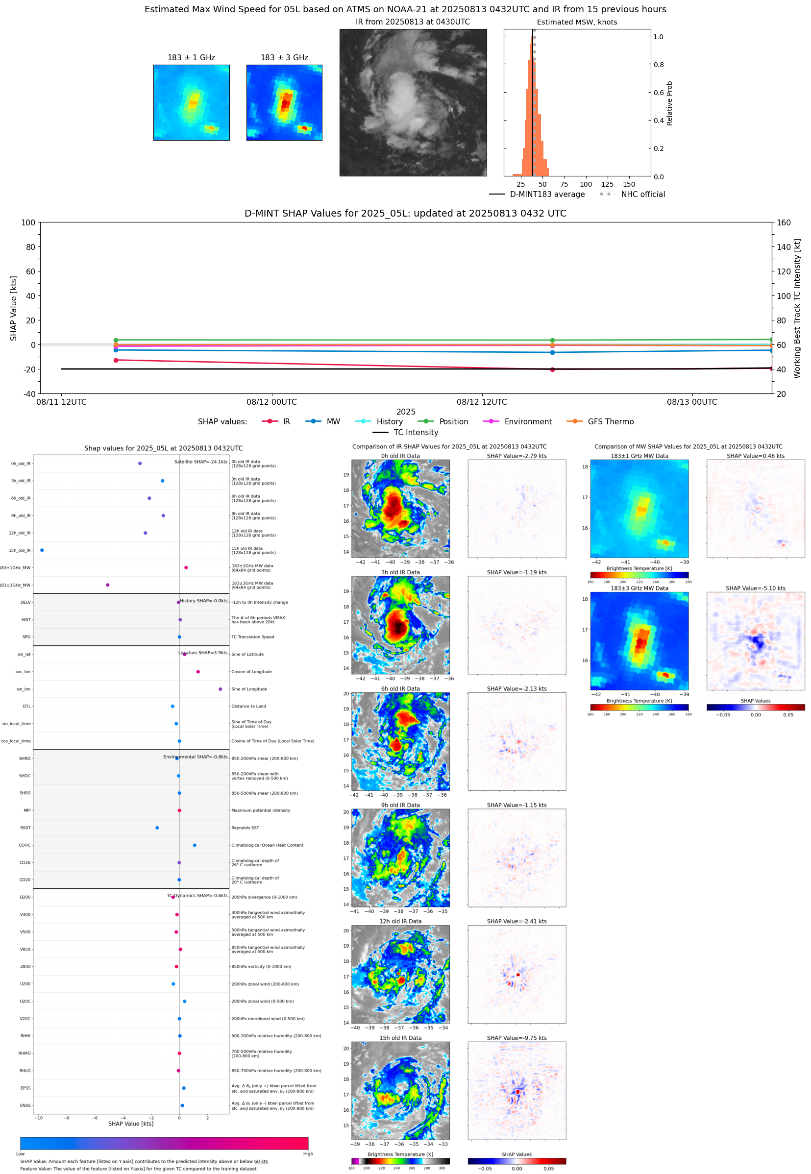 |
| 20250812 | 2058 UTC | SSMISF16 | 1007 hPa | 33 kts | 30 kts | 37 kts |  |
| 20250812 | 2032 UTC | SSMISF17 | 1005 hPa | 34 kts | 31 kts | 39 kts | 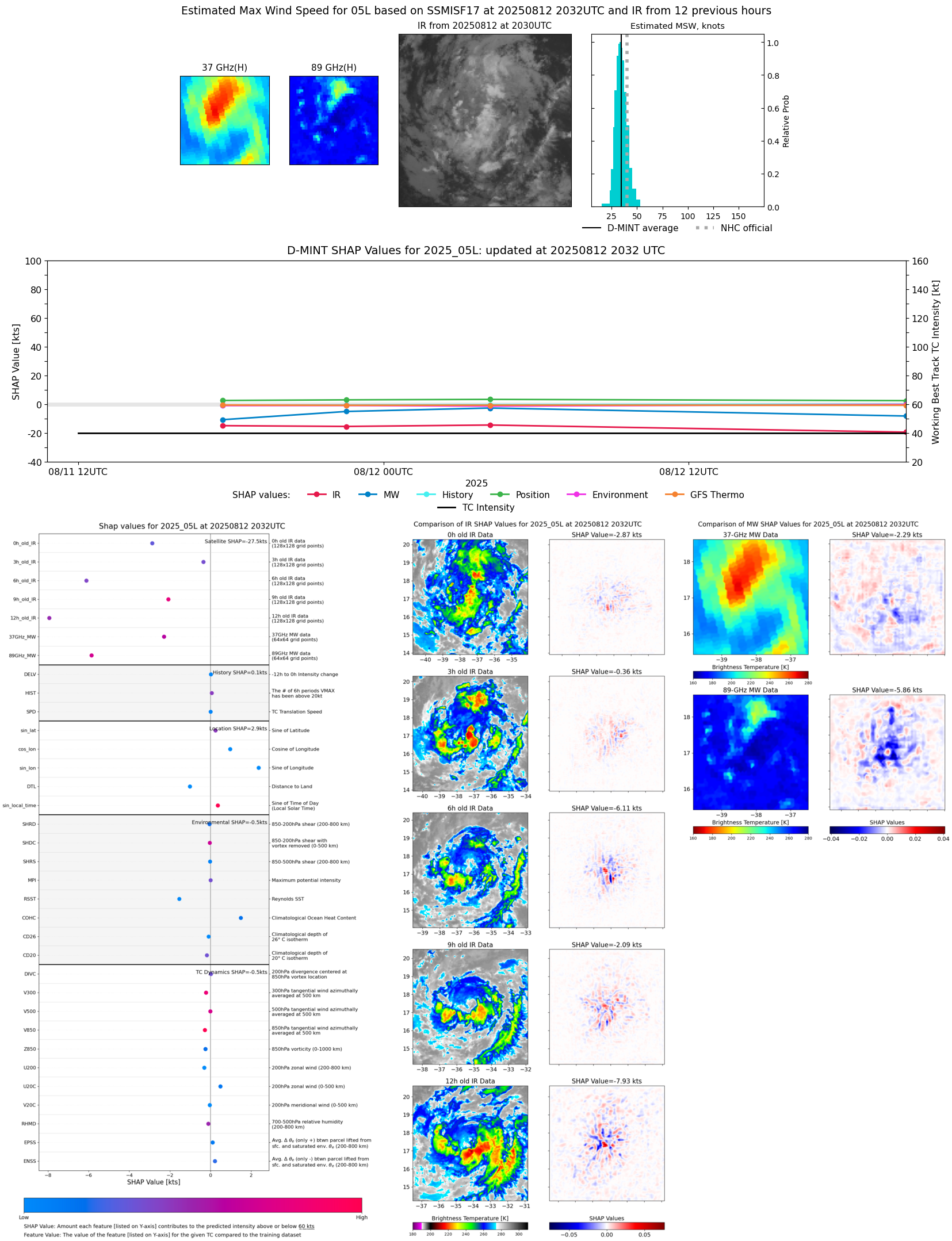 |
| 20250812 | 1600 UTC | ATMS-N21 | 1002 hPa | 36 kts | 33 kts | 40 kts | 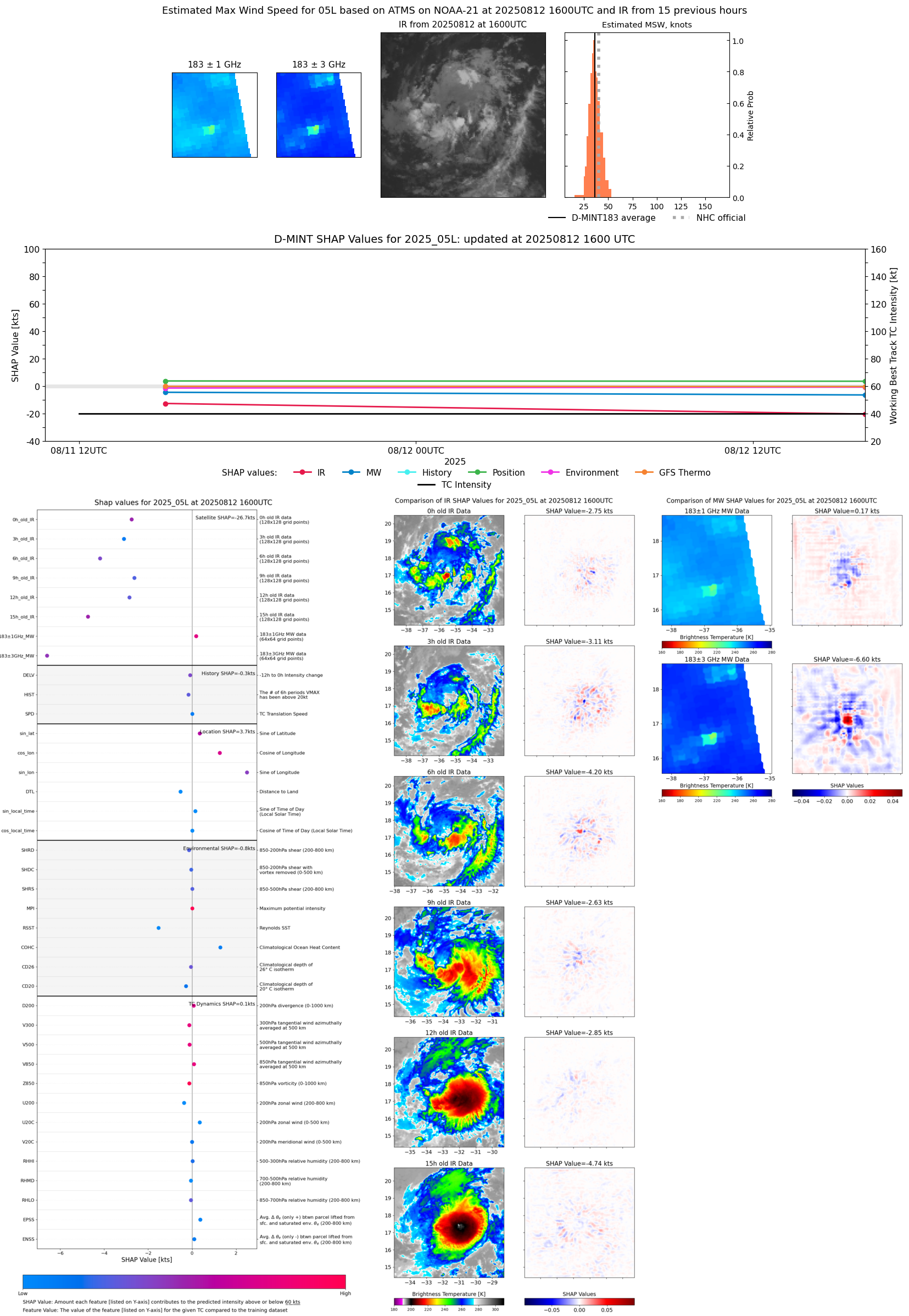 |
| 20250812 | 0411 UTC | AMSR2 | 1000 hPa | 44 kts | 40 kts | 49 kts |  |
| 20250812 | 0357 UTC | TROPICS05 | 999 hPa | 43 kts | 38 kts | 48 kts |  |
| 20250811 | 2233 UTC | GMI | 1002 hPa | 41 kts | 36 kts | 46 kts |  |
| 20250811 | 1947 UTC | TROPICS05 | 999 hPa | 38 kts | 34 kts | 44 kts |  |
| 20250811 | 1741 UTC | SSMISF18 | 1003 hPa | 35 kts | 31 kts | 39 kts | 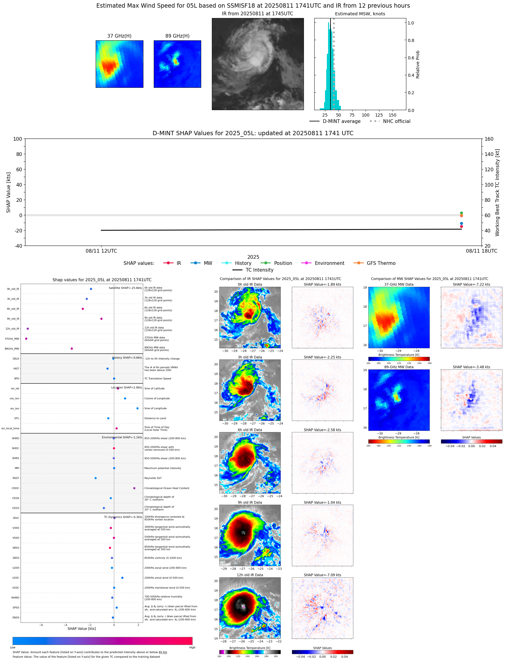 |
| 20250811 | 1505 UTC | ATMS-NPP | 999 hPa | 45 kts | 41 kts | 50 kts | 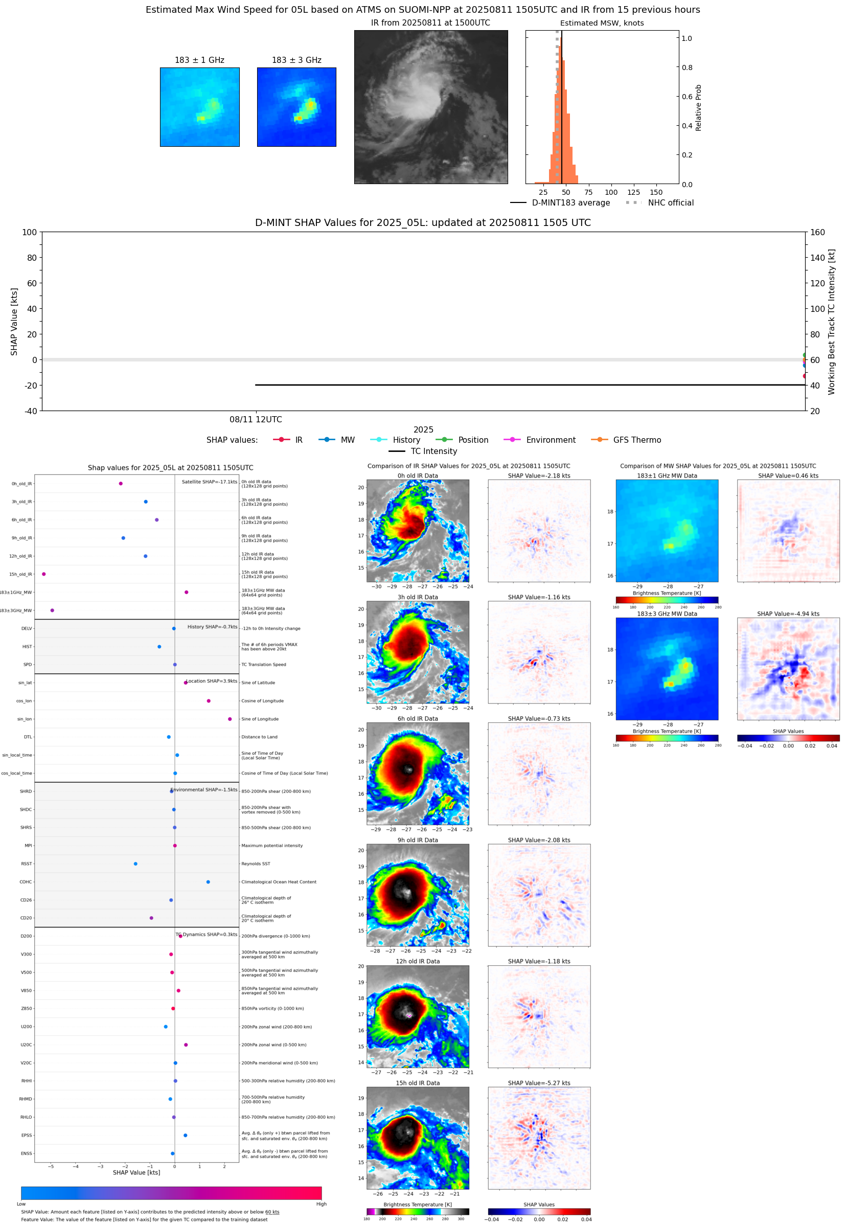 |
| 20250811 | 0917 UTC | GMI | NaN hPa | 36 kts | 32 kts | 39 kts |  |
| 20250811 | 0818 UTC | SSMISF16 | NaN hPa | 40 kts | 36 kts | 45 kts |  |
| 20250811 | 0753 UTC | SSMISF17 | NaN hPa | 42 kts | 37 kts | 47 kts |  |
| 20250811 | 0328 UTC | AMSR2 | NaN hPa | 36 kts | 32 kts | 40 kts |  |
| 20250810 | 1943 UTC | SSMISF16 | NaN hPa | 30 kts | 27 kts | 33 kts |  |
| 20250810 | 1919 UTC | SSMISF17 | NaN hPa | 29 kts | 26 kts | 32 kts |  |
| 20250810 | 0503 UTC | SSMISF18 | NaN hPa | 27 kts | 24 kts | 31 kts |  |
| 20250810 | 0246 UTC | AMSR2 | NaN hPa | 26 kts | 23 kts | 29 kts |  |
| 20250809 | 1955 UTC | SSMISF16 | NaN hPa | 28 kts | 24 kts | 32 kts |  |
| 20250809 | 1431 UTC | AMSR2 | NaN hPa | 25 kts | 22 kts | 28 kts | 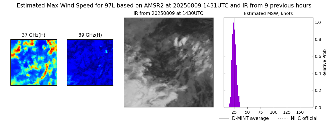 |