|
||

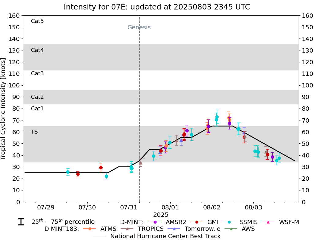 |
D-MINT HISTORY FILE for 2025_07E
| Date | Time | MW Sensor | MSLP | Vmax (30th-70th percentile average) | Vmax 25th percentile | Vmax 75th percentile | Image |
| 20250803 | 1453 UTC | SSMISF17 | 1008 hPa | 38 kts | 34 kts | 42 kts | 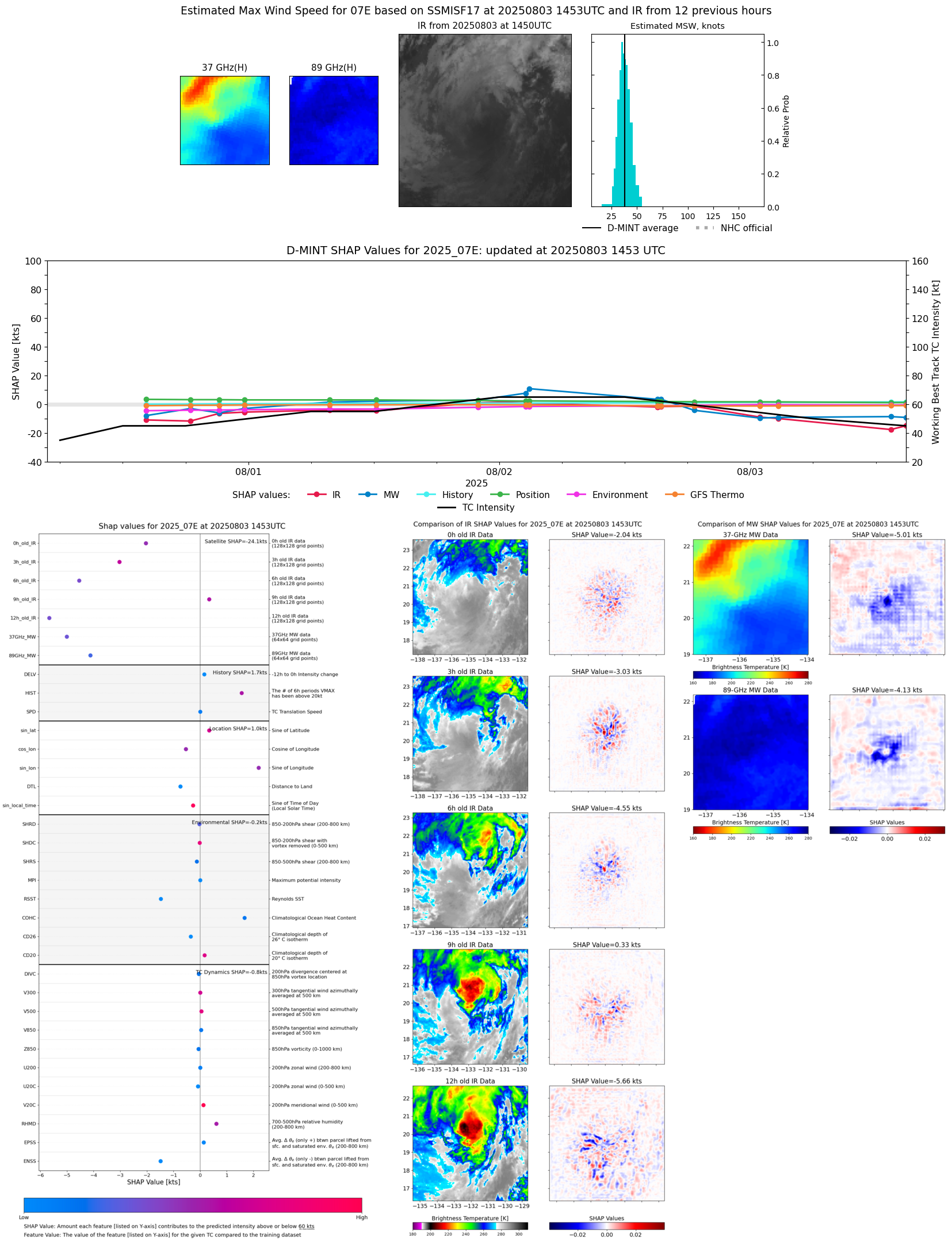 |
| 20250803 | 1326 UTC | SSMISF18 | 1007 hPa | 35 kts | 32 kts | 39 kts |  |
| 20250803 | 1052 UTC | AMSR2 | 1008 hPa | 38 kts | 35 kts | 43 kts | 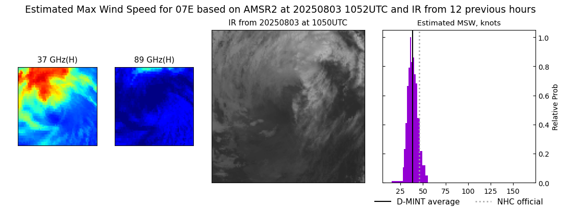 |
| 20250803 | 0803 UTC | GMI | 1007 hPa | 41 kts | 36 kts | 45 kts | 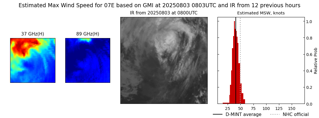 |
| 20250803 | 0709 UTC | TROPICS05 | 1005 hPa | 43 kts | 39 kts | 47 kts |  |
| 20250803 | 0242 UTC | SSMISF16 | 1004 hPa | 43 kts | 38 kts | 47 kts |  |
| 20250803 | 0220 UTC | SSMISF17 | 1004 hPa | 43 kts | 39 kts | 48 kts |  |
| 20250803 | 0054 UTC | SSMISF18 | 1002 hPa | 43 kts | 39 kts | 49 kts | 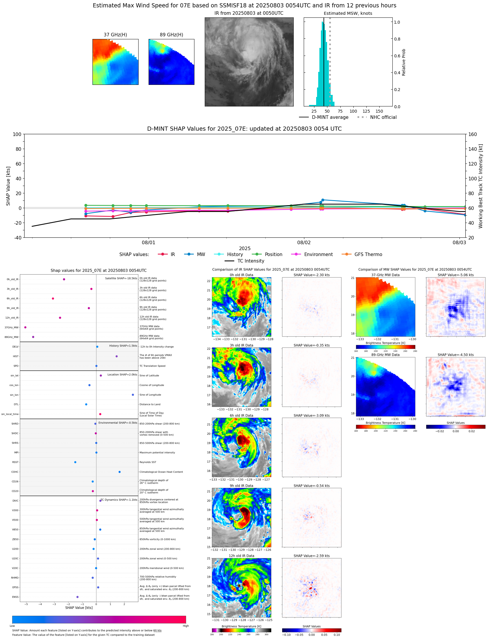 |
| 20250802 | 1902 UTC | TROPICS03 | 995 hPa | 56 kts | 52 kts | 60 kts | 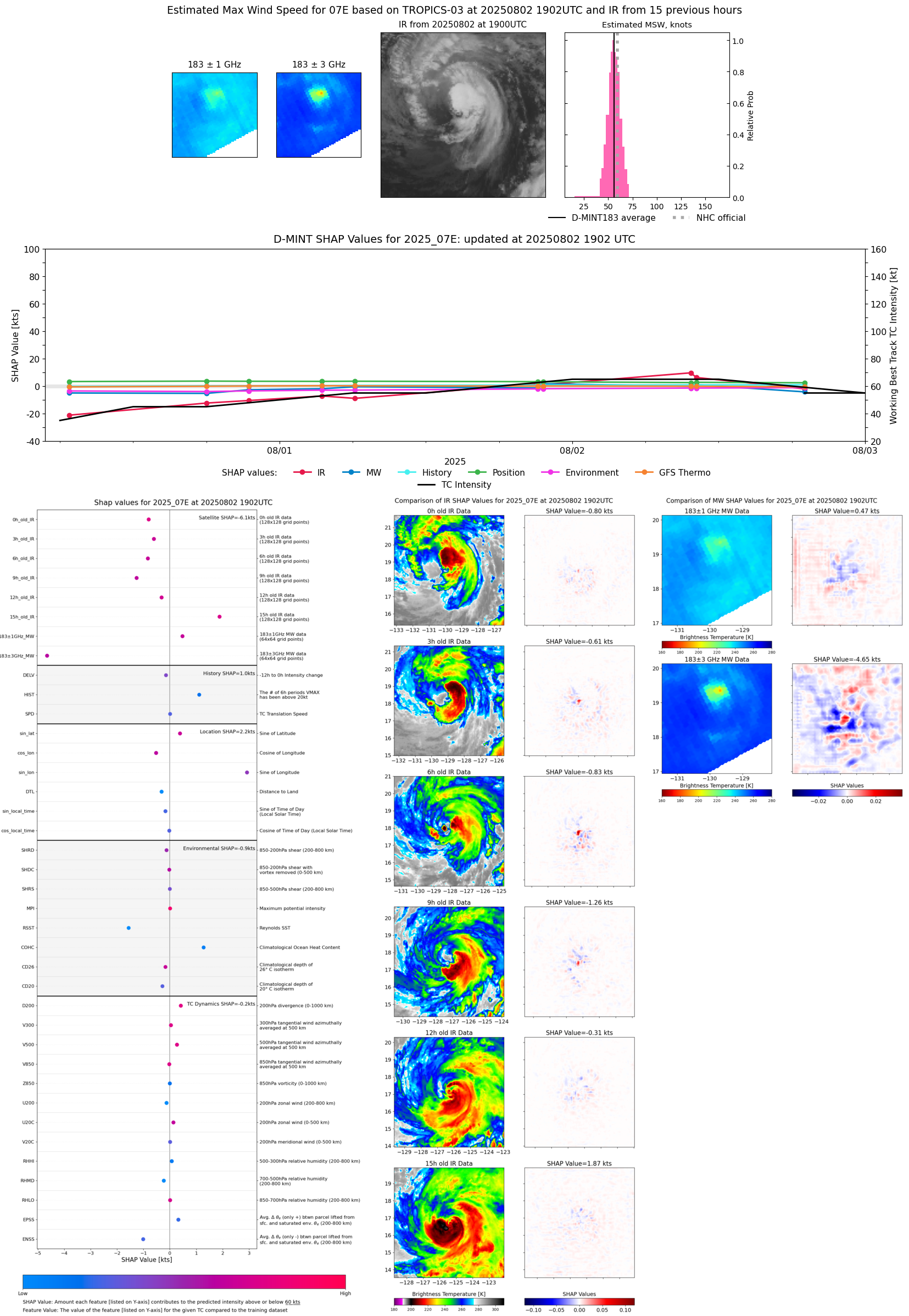 |
| 20250802 | 1838 UTC | GMI | 996 hPa | 56 kts | 51 kts | 61 kts |  |
| 20250802 | 1831 UTC | TMS05 | 998 hPa | 60 kts | 55 kts | 64 kts | 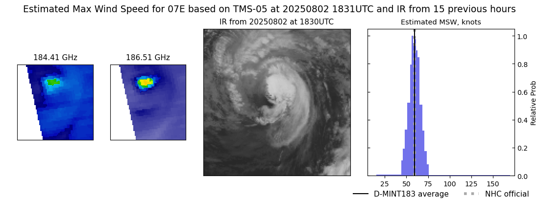 |
| 20250802 | 1527 UTC | SSMISF16 | 993 hPa | 63 kts | 58 kts | 68 kts | 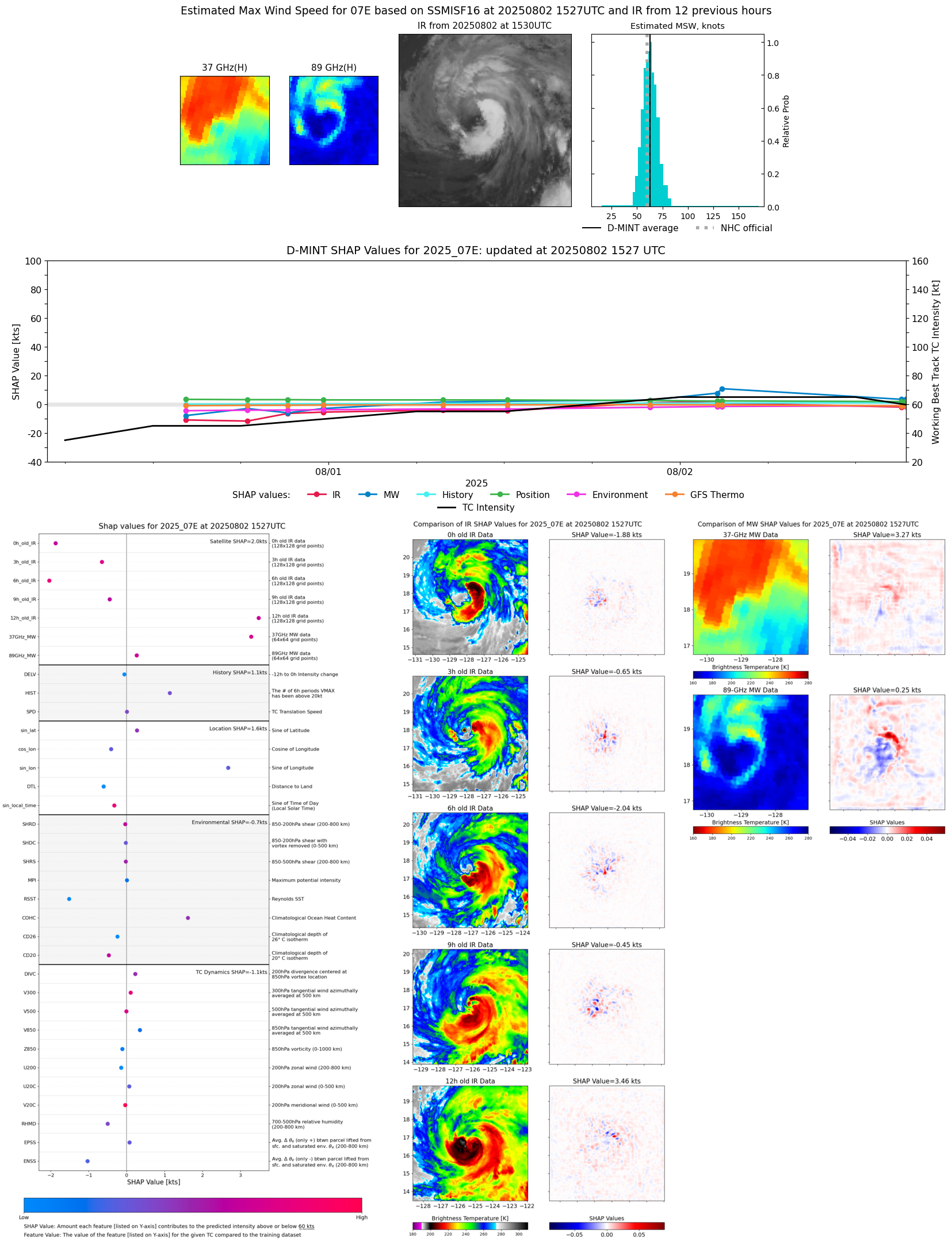 |
| 20250802 | 1507 UTC | SSMISF17 | 992 hPa | 62 kts | 57 kts | 68 kts |  |
| 20250802 | 1010 UTC | AMSR2 | 988 hPa | 67 kts | 62 kts | 72 kts | 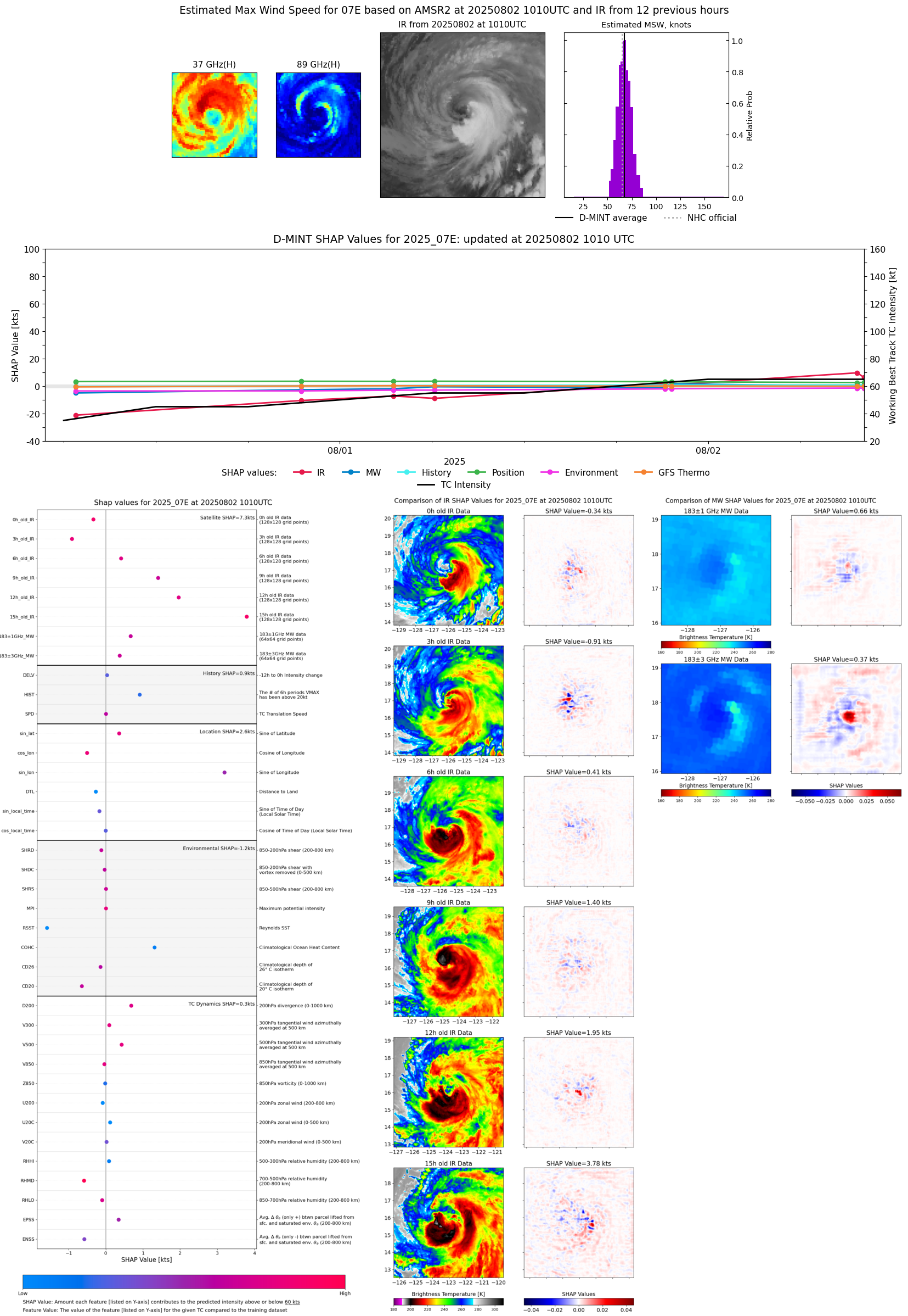 |
| 20250802 | 1010 UTC | ATMS-NPP | 986 hPa | 70 kts | 65 kts | 75 kts | 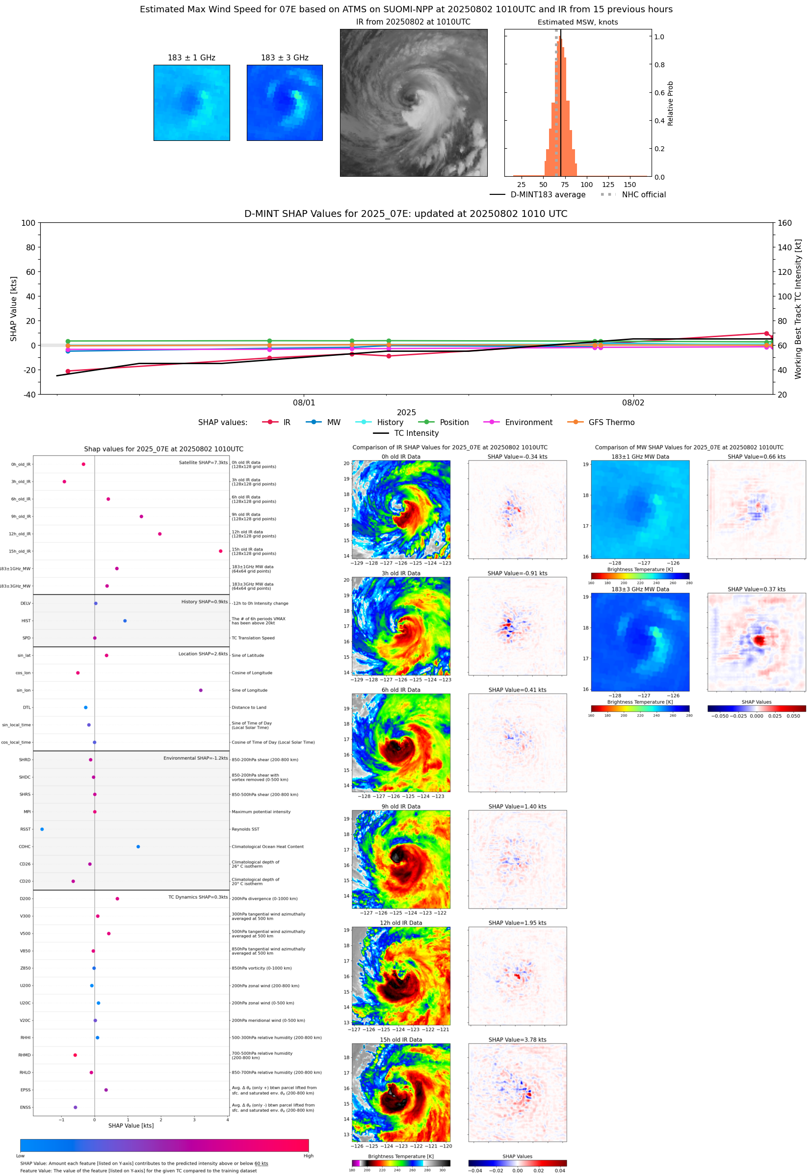 |
| 20250802 | 0943 UTC | ATMS-N21 | 985 hPa | 72 kts | 67 kts | 77 kts | 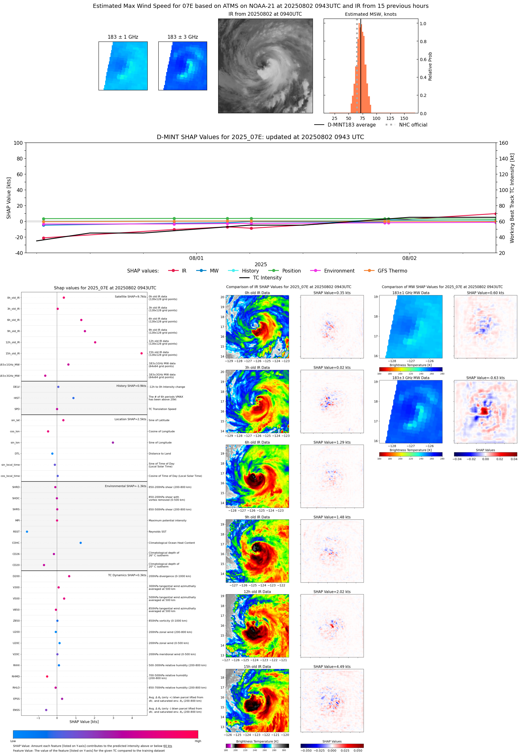 |
| 20250802 | 0253 UTC | SSMISF16 | 982 hPa | 73 kts | 67 kts | 79 kts | 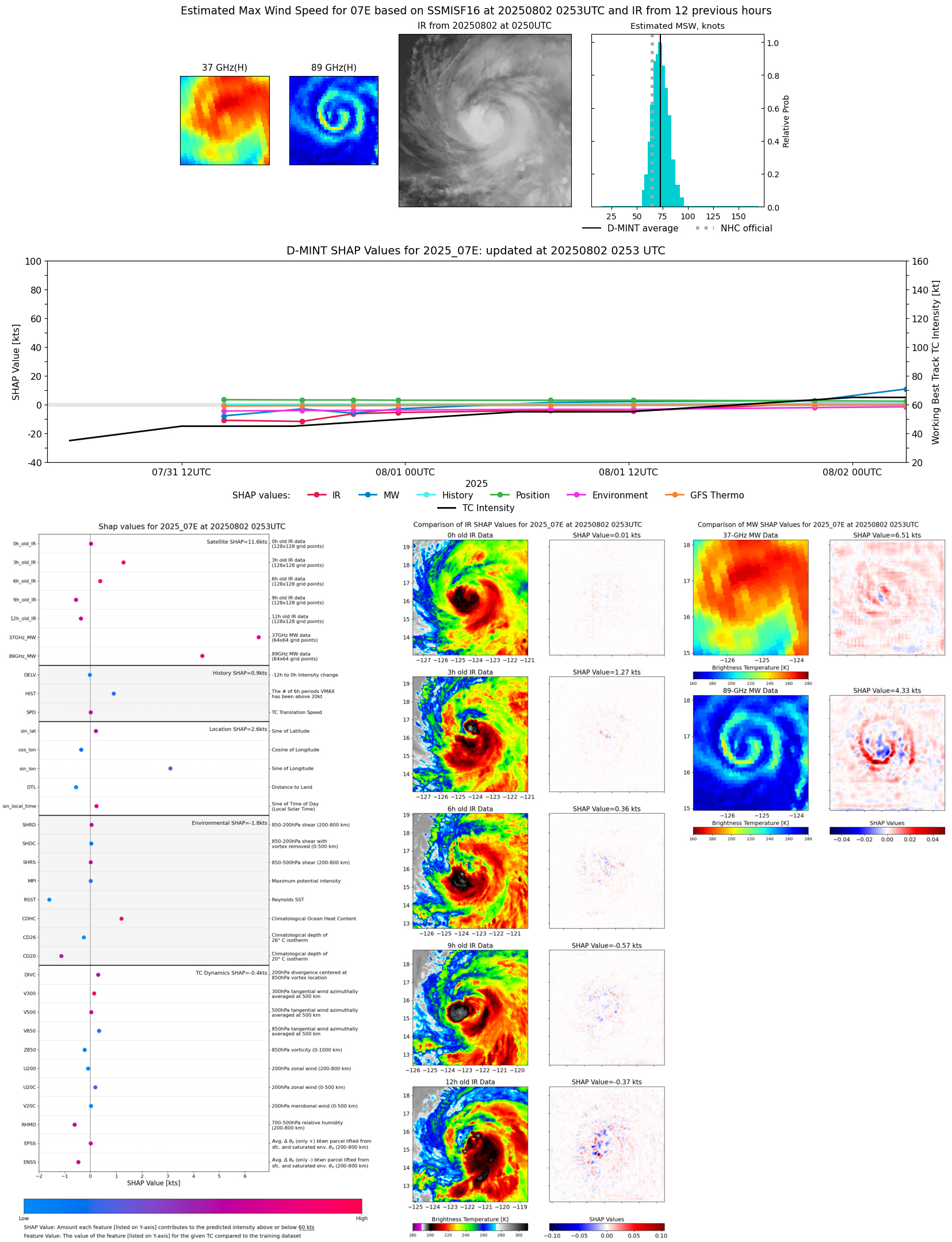 |
| 20250802 | 0233 UTC | SSMISF17 | 984 hPa | 71 kts | 65 kts | 76 kts | 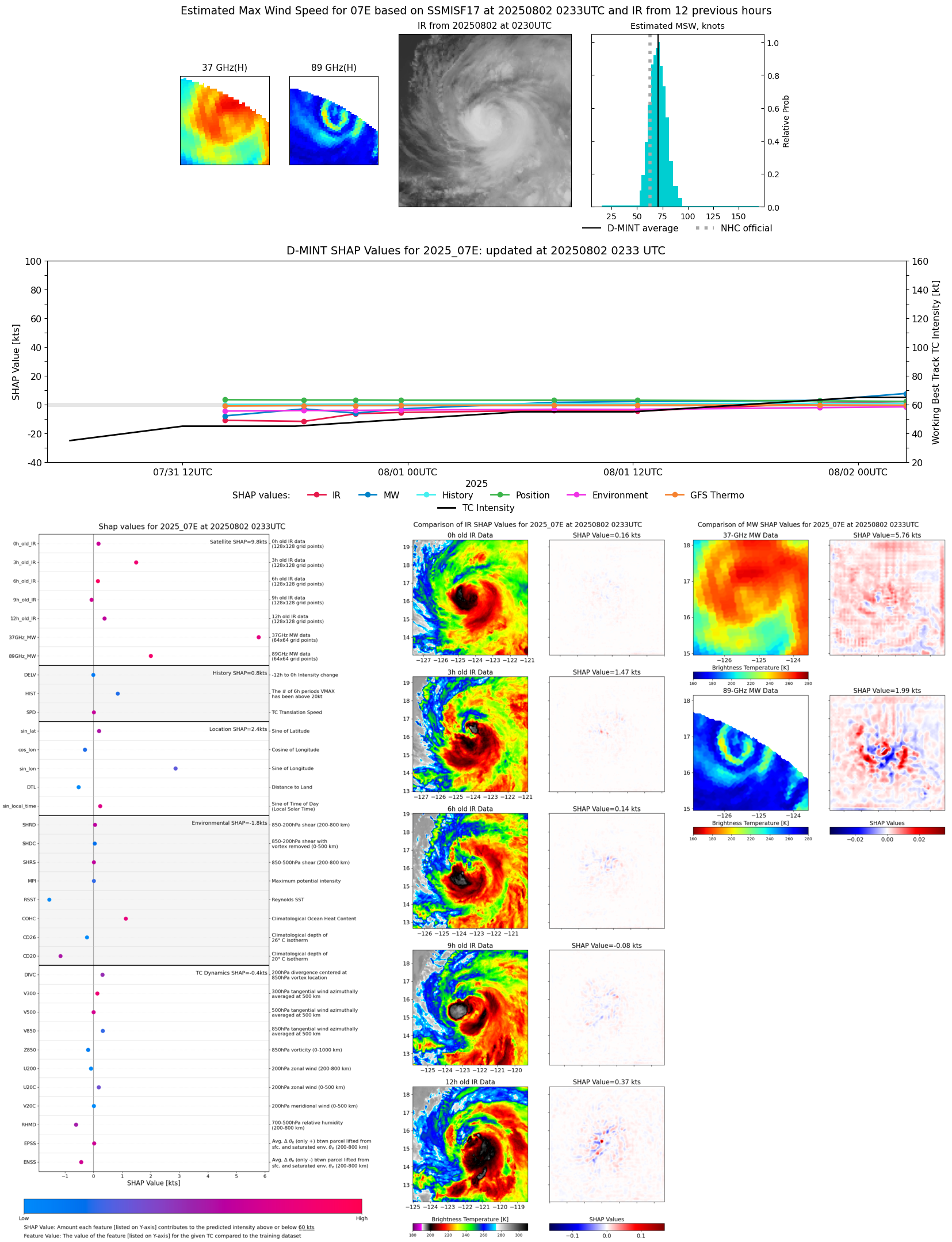 |
| 20250802 | 0233 UTC | SSMISF17 | 983 hPa | 71 kts | 66 kts | 77 kts | 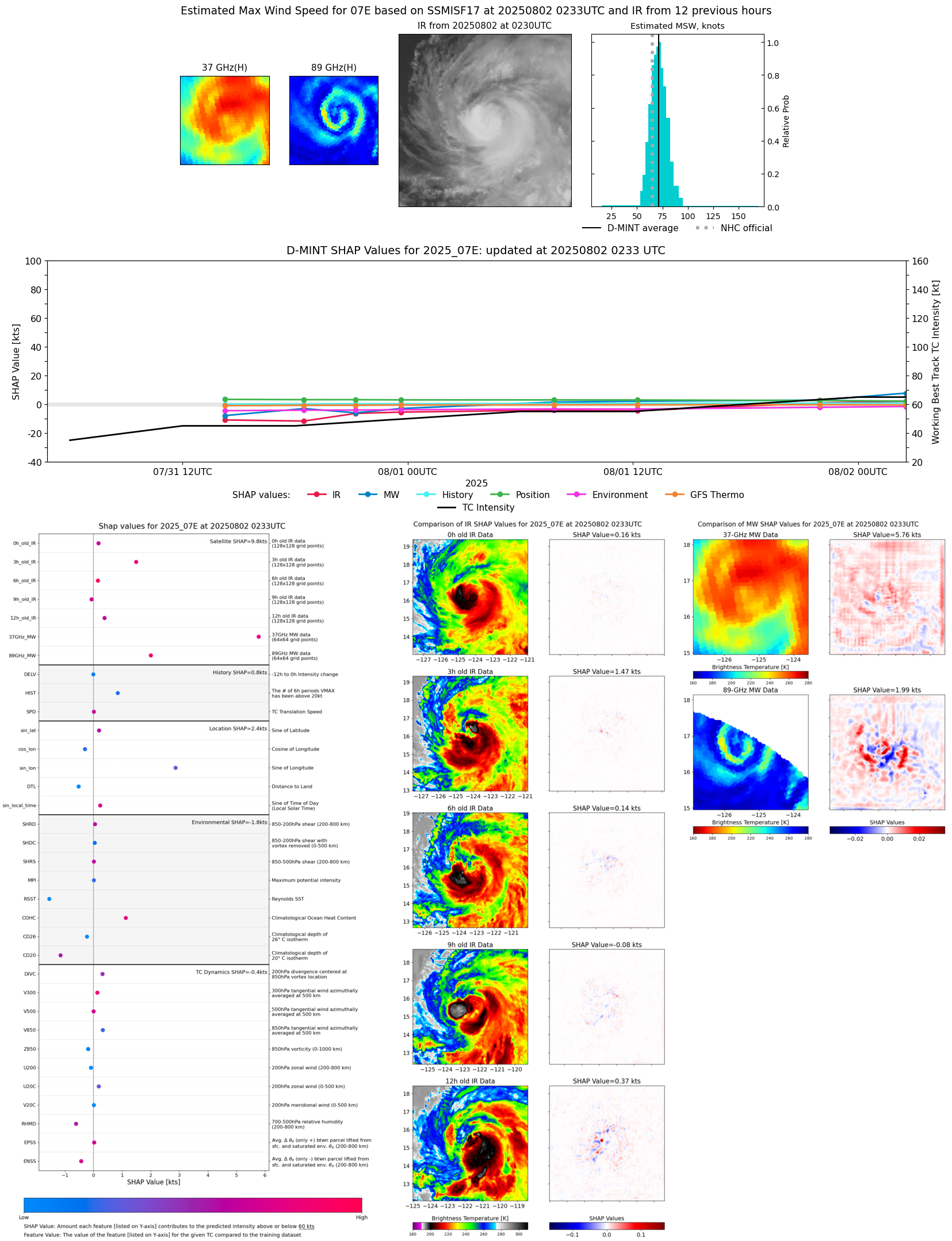 |
| 20250801 | 2158 UTC | AMSR2 | 988 hPa | 65 kts | 59 kts | 71 kts | 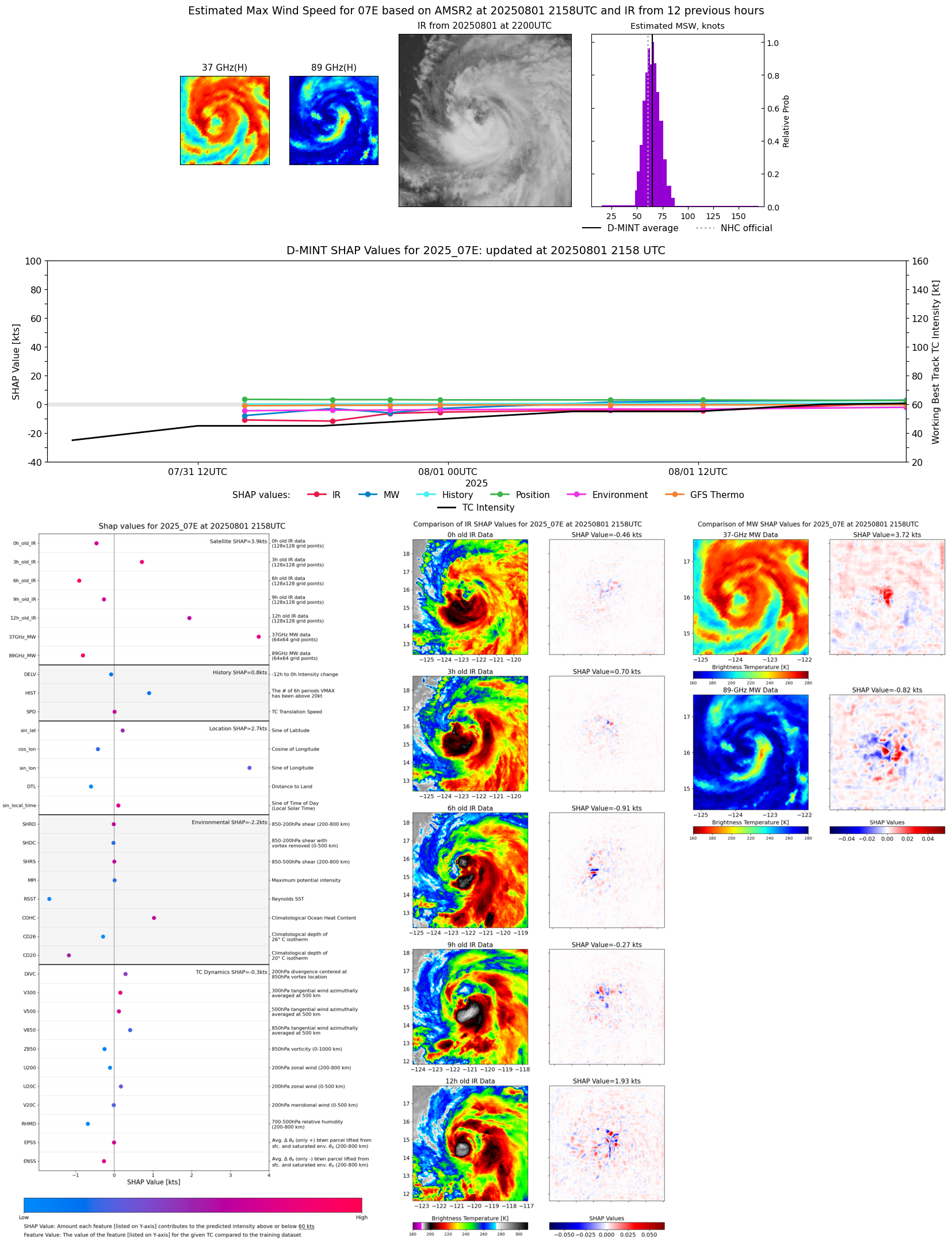 |
| 20250801 | 2138 UTC | ATMS-NPP | 986 hPa | 66 kts | 60 kts | 71 kts |  |
| 20250801 | 2111 UTC | ATMS-N21 | 986 hPa | 63 kts | 58 kts | 68 kts |  |
| 20250801 | 1214 UTC | SSMISF18 | 989 hPa | 58 kts | 53 kts | 63 kts | 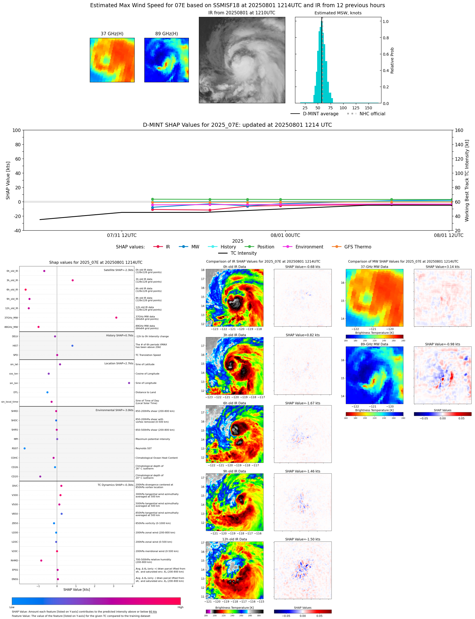 |
| 20250801 | 0927 UTC | AMSR2 | 990 hPa | 61 kts | 56 kts | 66 kts |  |
| 20250801 | 0754 UTC | GMI | 993 hPa | 58 kts | 54 kts | 63 kts | 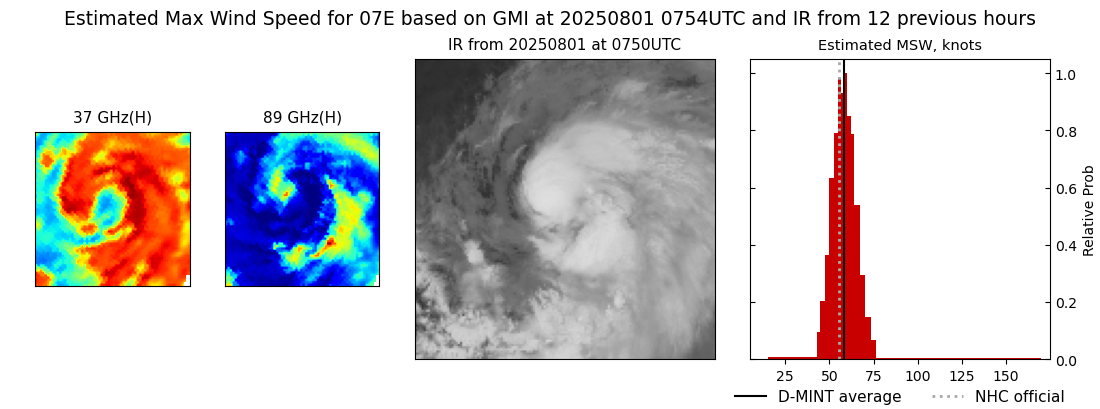 |
| 20250801 | 0748 UTC | GMI | 993 hPa | 57 kts | 53 kts | 62 kts | 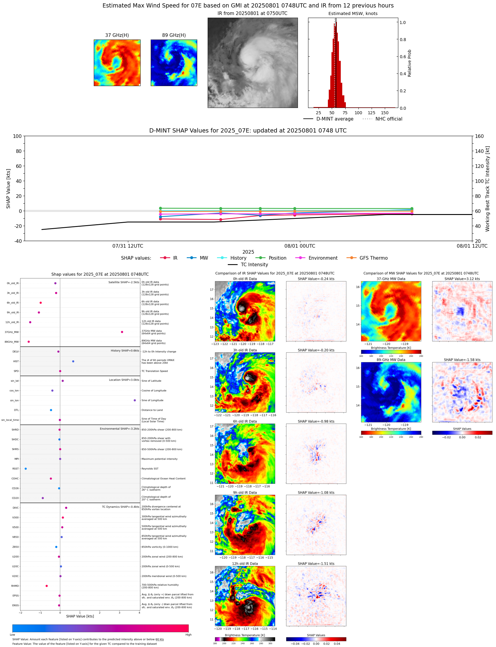 |
| 20250801 | 0610 UTC | TMS02 | 987 hPa | 53 kts | 48 kts | 58 kts | 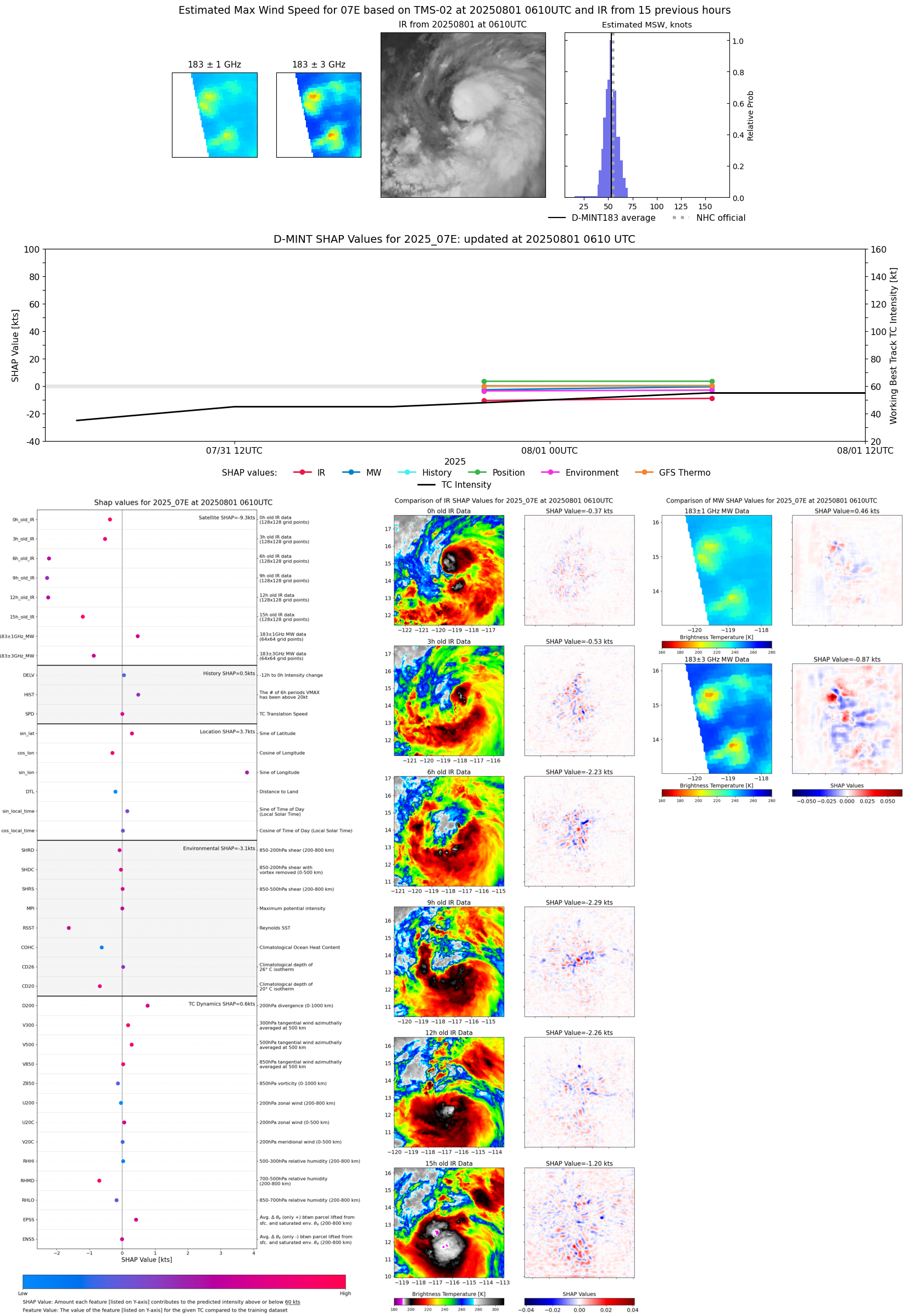 |
| 20250801 | 0329 UTC | TROPICS03 | 989 hPa | 53 kts | 48 kts | 57 kts | 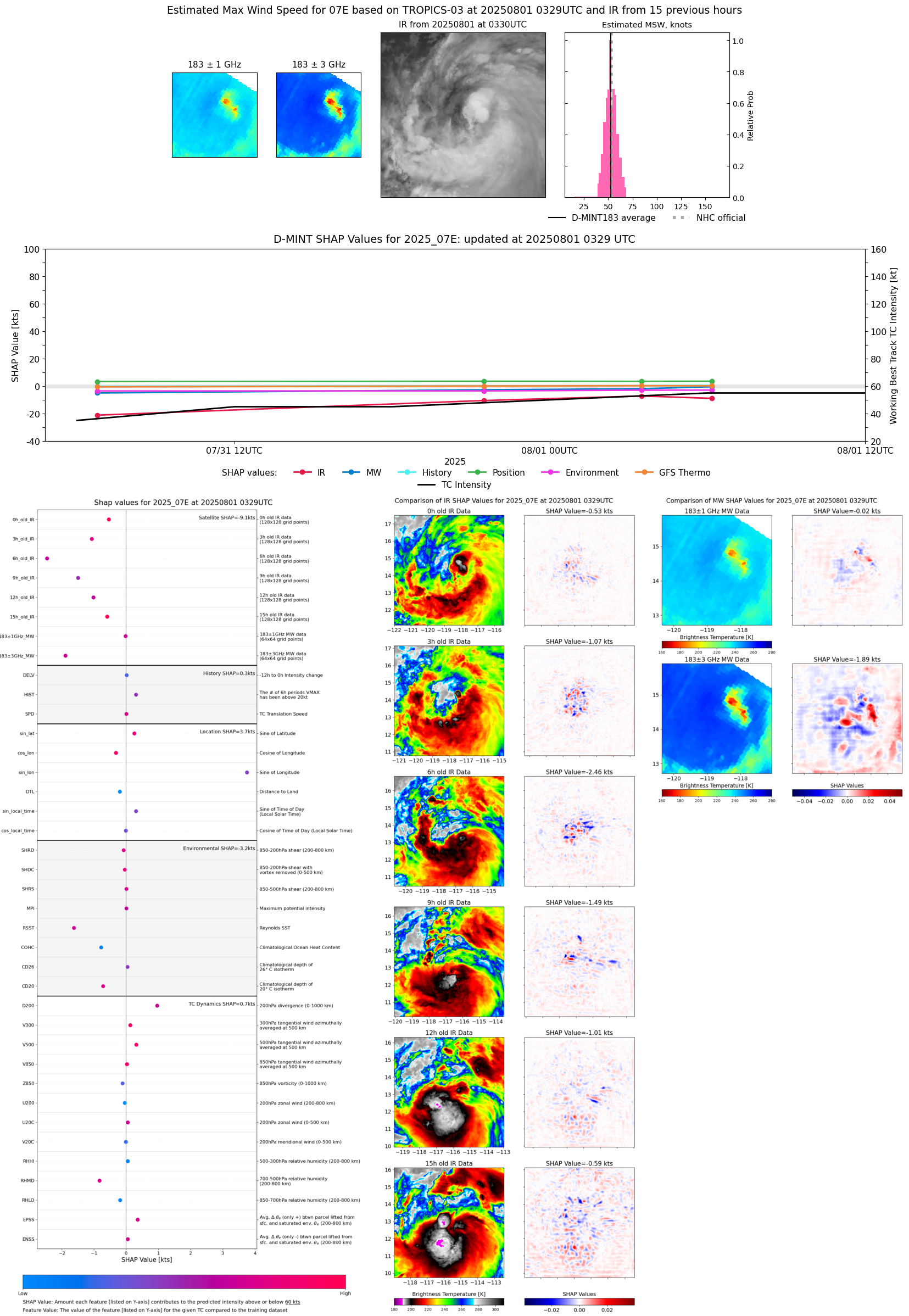 |
| 20250731 | 2338 UTC | SSMISF18 | 995 hPa | 51 kts | 46 kts | 56 kts |  |
| 20250731 | 2129 UTC | ATMS-N21 | 996 hPa | 48 kts | 43 kts | 53 kts |  |
| 20250731 | 2113 UTC | AMSR2 | 999 hPa | 47 kts | 42 kts | 52 kts | 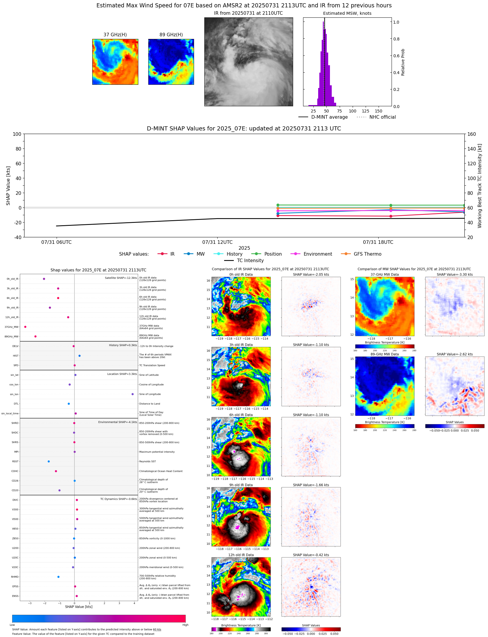 |
| 20250731 | 1828 UTC | GMI | 1000 hPa | 44 kts | 39 kts | 49 kts |  |
| 20250731 | 1801 UTC | TMS02 | 998 hPa | 43 kts | 39 kts | 48 kts |  |
| 20250731 | 1415 UTC | SSMISF16 | 1005 hPa | 39 kts | 35 kts | 44 kts | 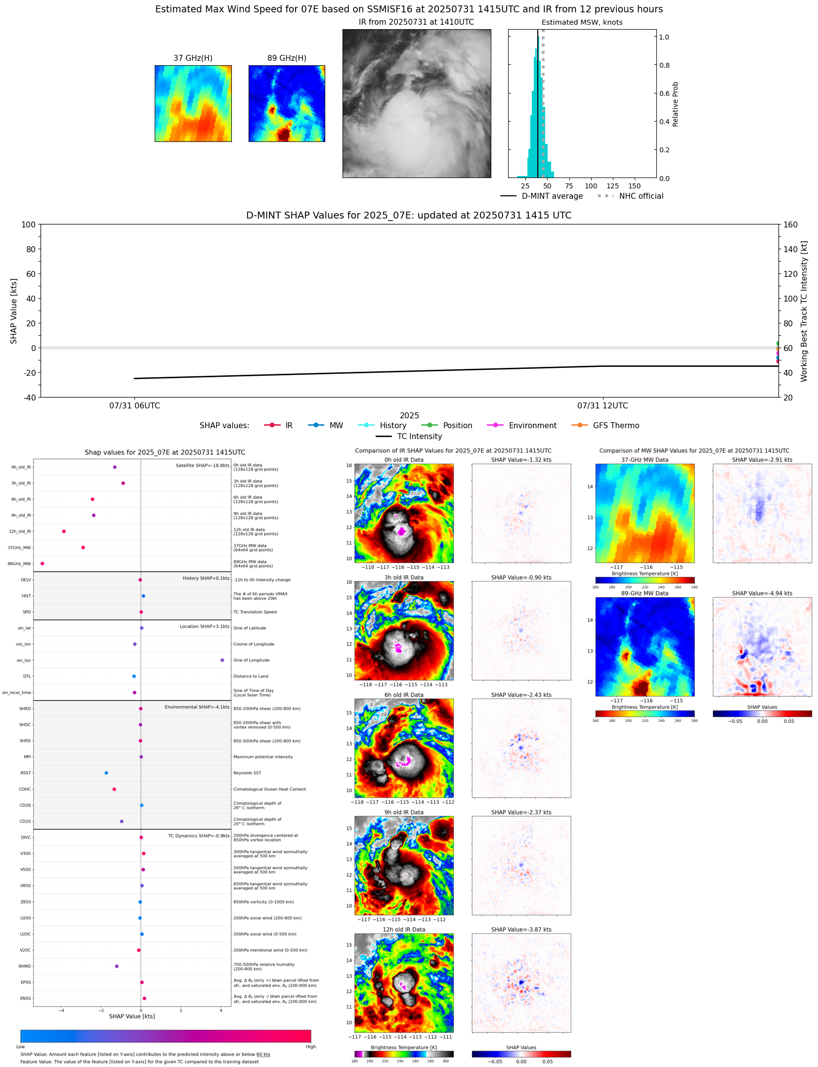 |
| 20250731 | 0646 UTC | TROPICS05 | 1005 hPa | 34 kts | 30 kts | 38 kts | 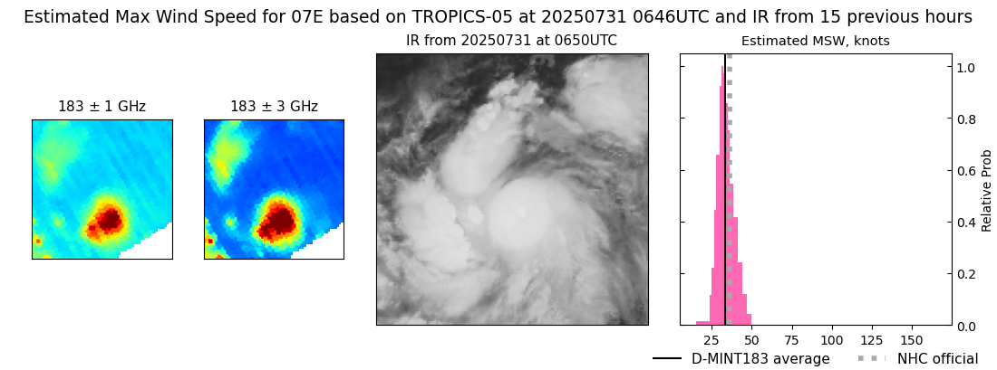 |
| 20250731 | 0139 UTC | SSMISF16 | NaN hPa | 29 kts | 25 kts | 33 kts | 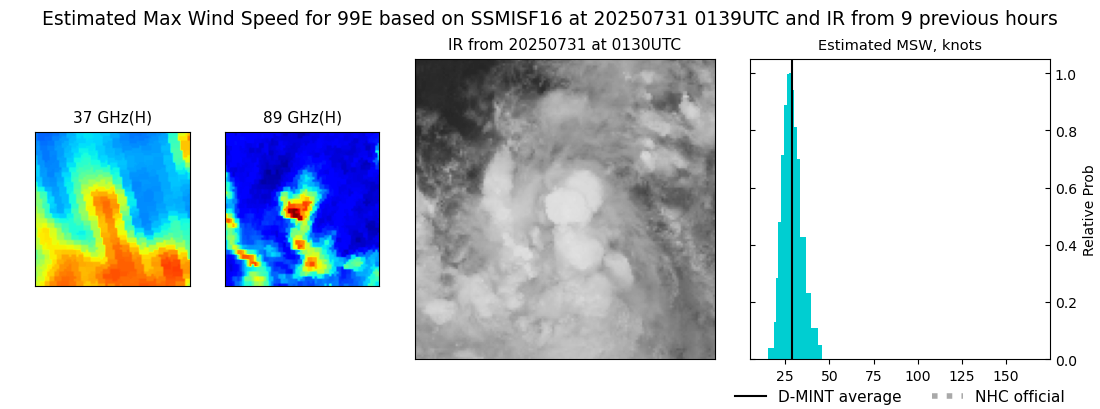 |
| 20250731 | 0119 UTC | SSMISF17 | NaN hPa | 30 kts | 26 kts | 35 kts |  |
| 20250731 | 0119 UTC | SSMISF17 | NaN hPa | 29 kts | 25 kts | 33 kts | 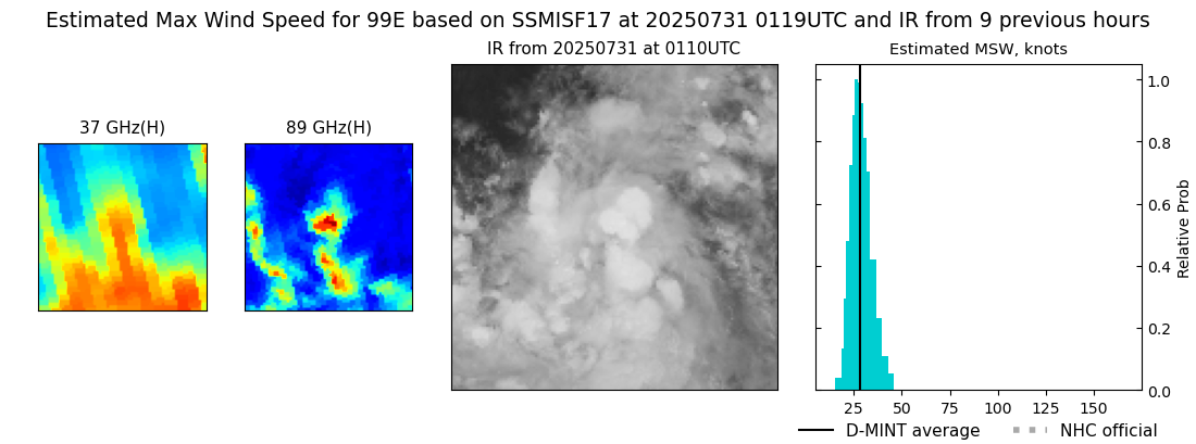 |
| 20250730 | 1102 UTC | SSMISF18 | NaN hPa | 22 kts | 20 kts | 25 kts |  |
| 20250730 | 0745 UTC | GMI | NaN hPa | 29 kts | 26 kts | 33 kts | 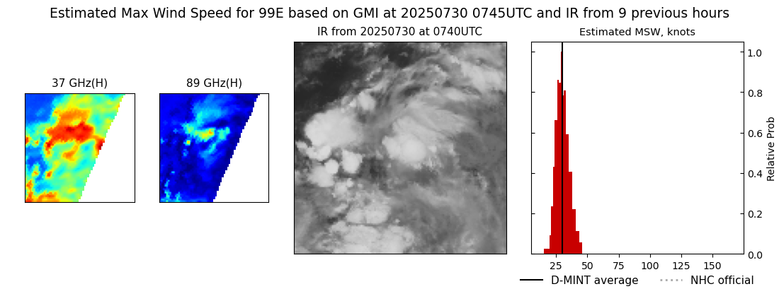 |
| 20250729 | 1825 UTC | GMI | NaN hPa | 24 kts | 21 kts | 26 kts | 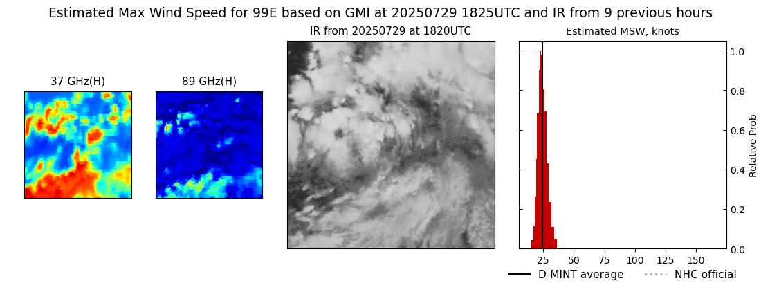 |
| 20250729 | 1243 UTC | SSMISF17 | NaN hPa | 26 kts | 23 kts | 29 kts | 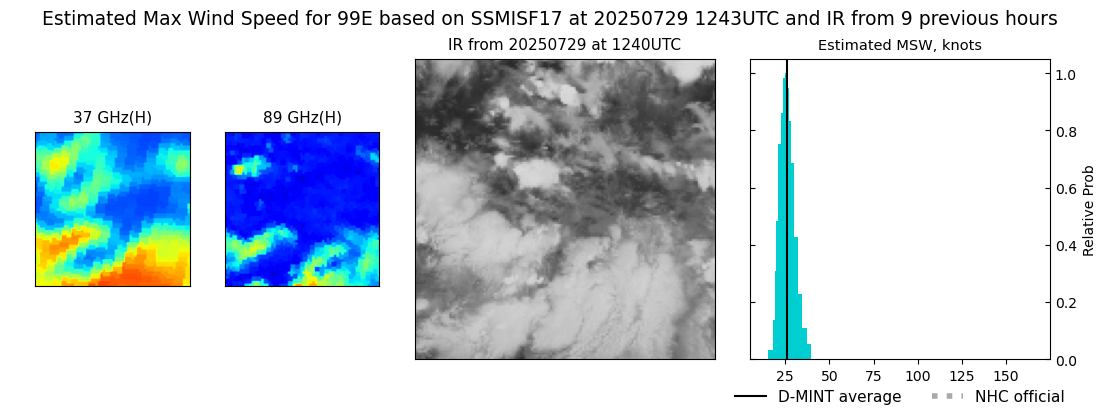 |