|
||

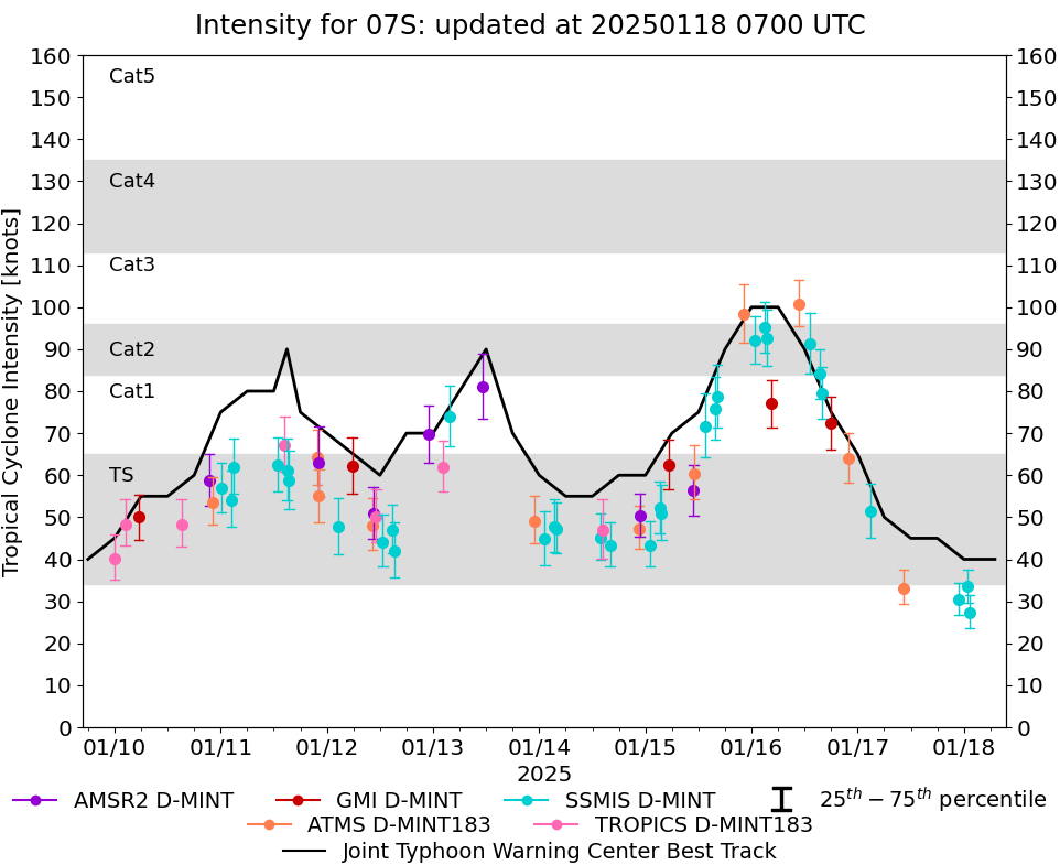 |
D-MINT HISTORY FILE for 2025_07S
| Date | Time | MW Sensor | MSLP | Vmax (30th-70th percentile average) | Vmax 25th percentile | Vmax 75th percentile | Image |
| 20250118 | 0121 UTC | SSMISF16 | 994 hPa | 27 kts | 24 kts | 32 kts | 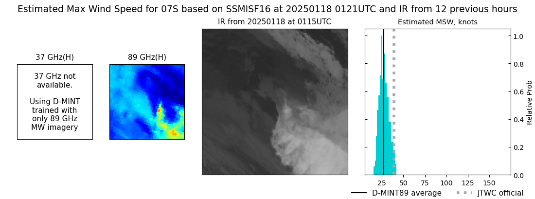 |
| 20250118 | 0054 UTC | SSMISF17 | 994 hPa | 34 kts | 30 kts | 37 kts | 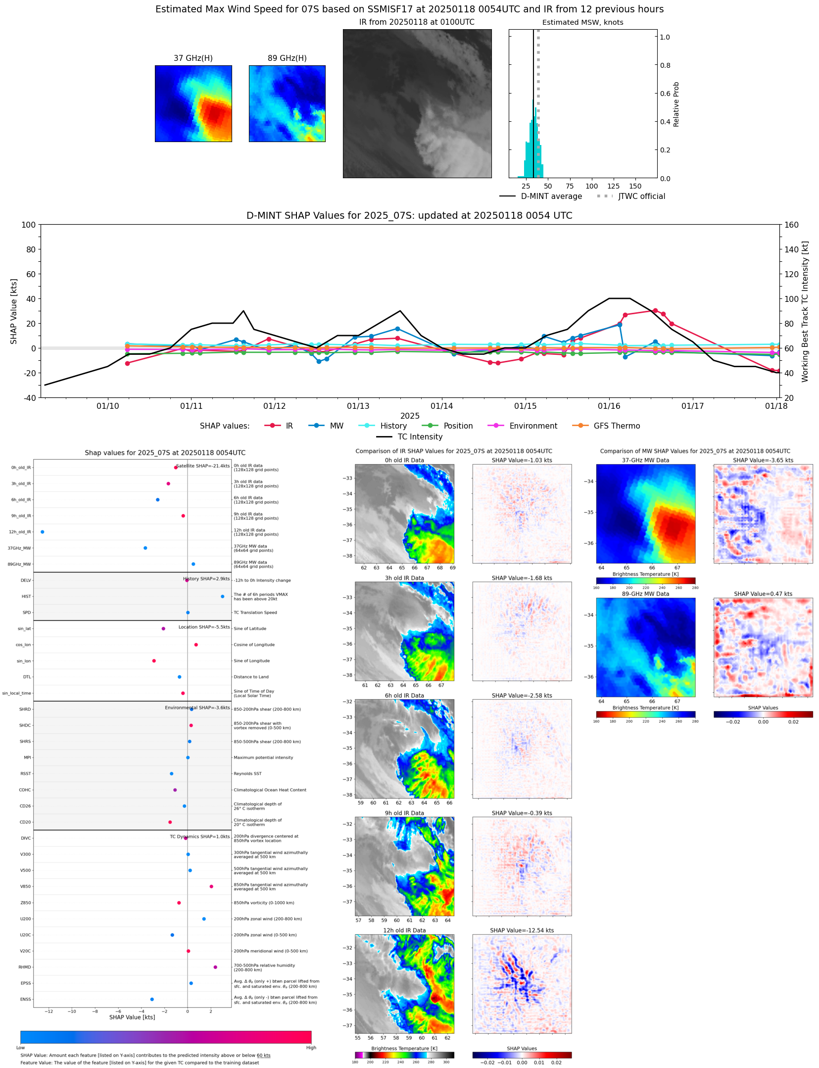 |
| 20250117 | 2245 UTC | SSMISF18 | 992 hPa | 31 kts | 27 kts | 34 kts | 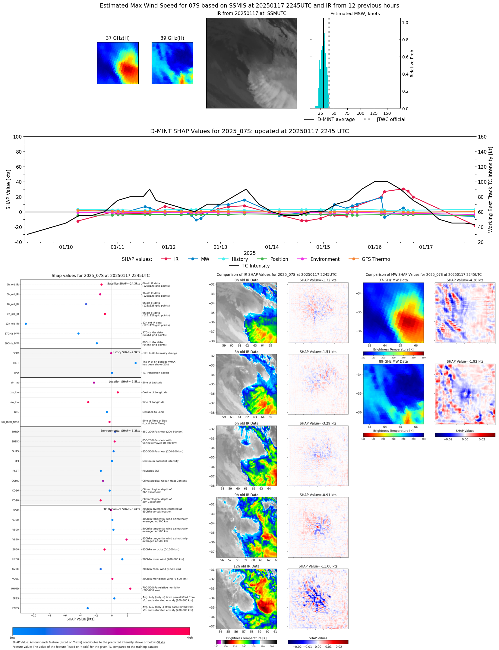 |
| 20250117 | 1022 UTC | ATMS-N20 | NaN hPa | 33 kts | 29 kts | 38 kts | 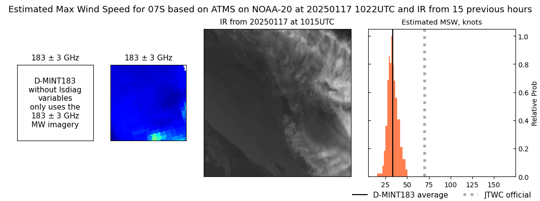 |
| 20250117 | 0249 UTC | SSMISF17 | NaN hPa | 51 kts | 45 kts | 58 kts | 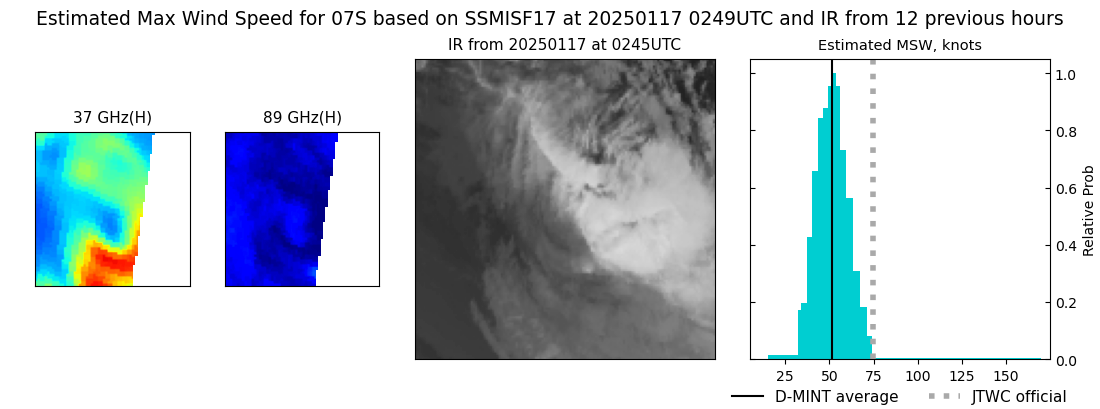 |
| 20250116 | 2159 UTC | ATMS-N20 | NaN hPa | 64 kts | 58 kts | 70 kts | 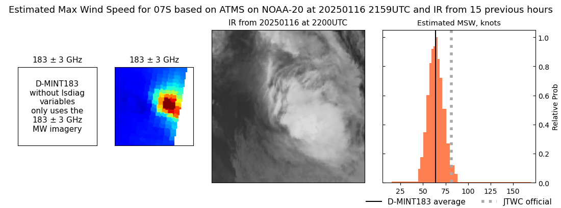 |
| 20250116 | 1758 UTC | GMI | 970 hPa | 72 kts | 66 kts | 79 kts | 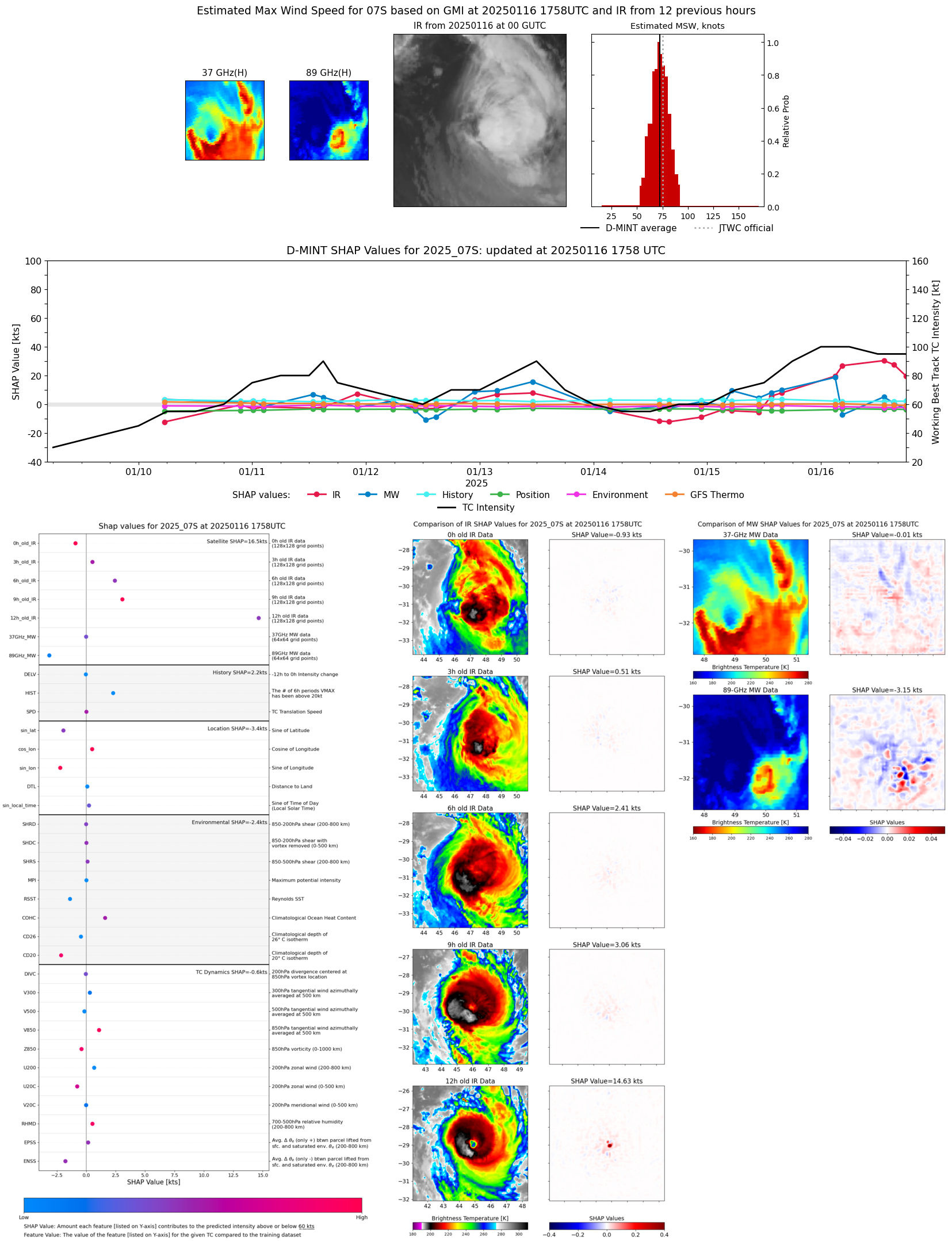 |
| 20250116 | 1556 UTC | SSMISF16 | 965 hPa | 80 kts | 73 kts | 86 kts | 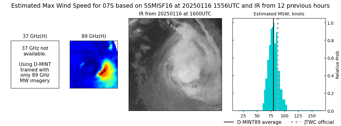 |
| 20250116 | 1528 UTC | SSMISF17 | 961 hPa | 84 kts | 78 kts | 90 kts | 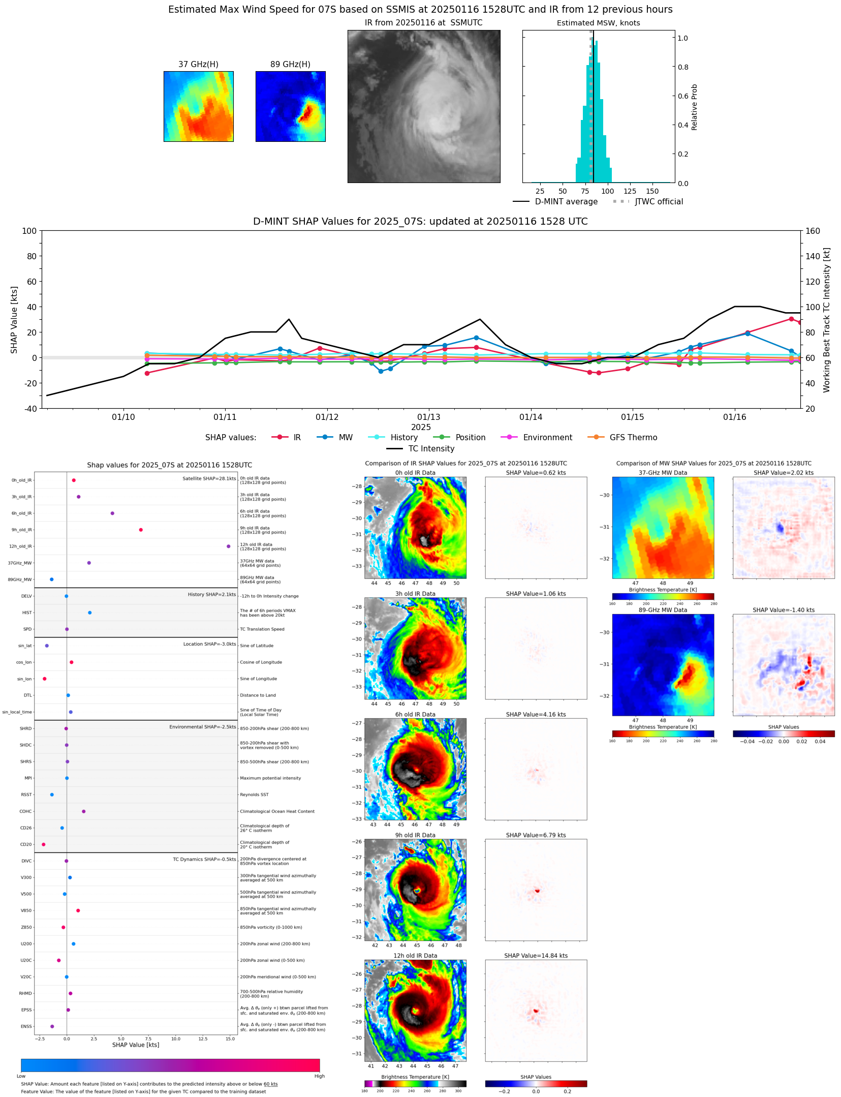 |
| 20250116 | 1318 UTC | SSMISF18 | 956 hPa | 91 kts | 84 kts | 99 kts | 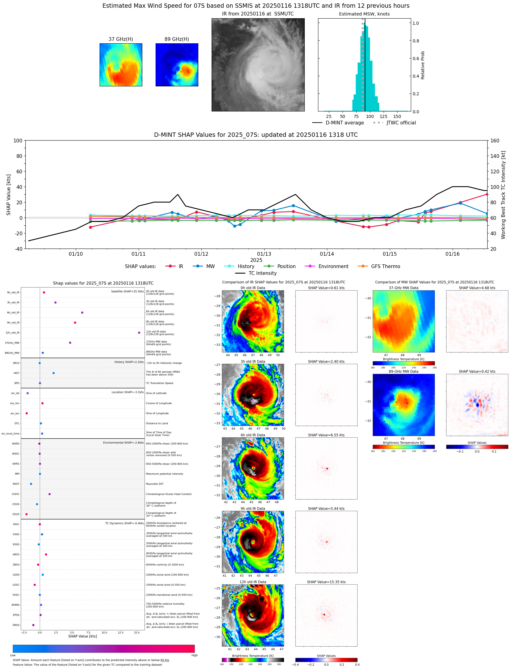 |
| 20250116 | 1043 UTC | ATMS-N20 | 951 hPa | 101 kts | 96 kts | 106 kts | 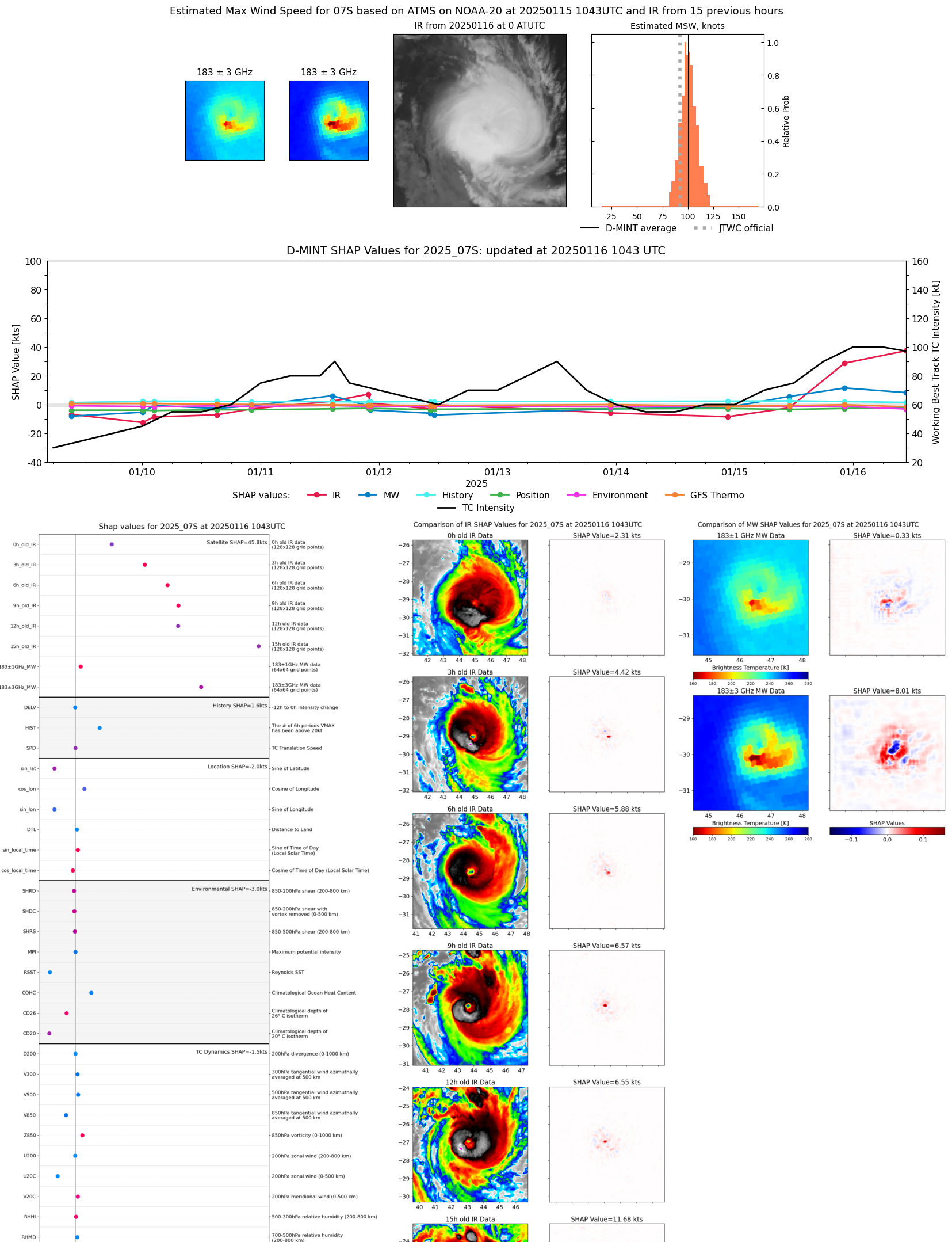 |
| 20250116 | 0433 UTC | GMI | 956 hPa | 77 kts | 71 kts | 83 kts | 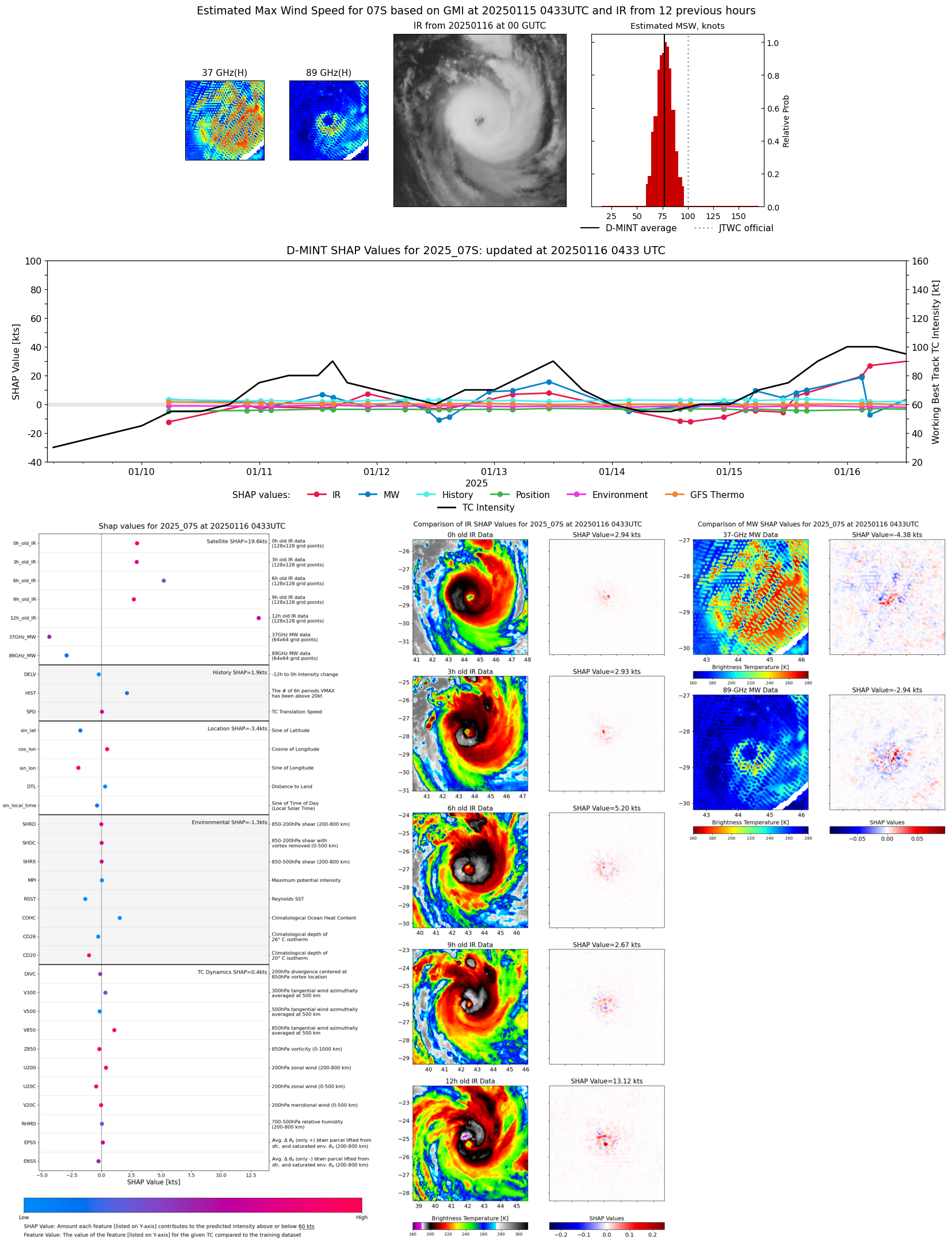 |
| 20250116 | 0329 UTC | SSMISF16 | 953 hPa | 93 kts | 86 kts | 99 kts | 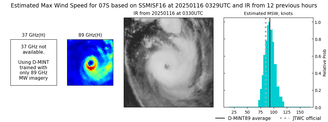 |
| 20250116 | 0301 UTC | SSMISF17 | 945 hPa | 95 kts | 89 kts | 101 kts | 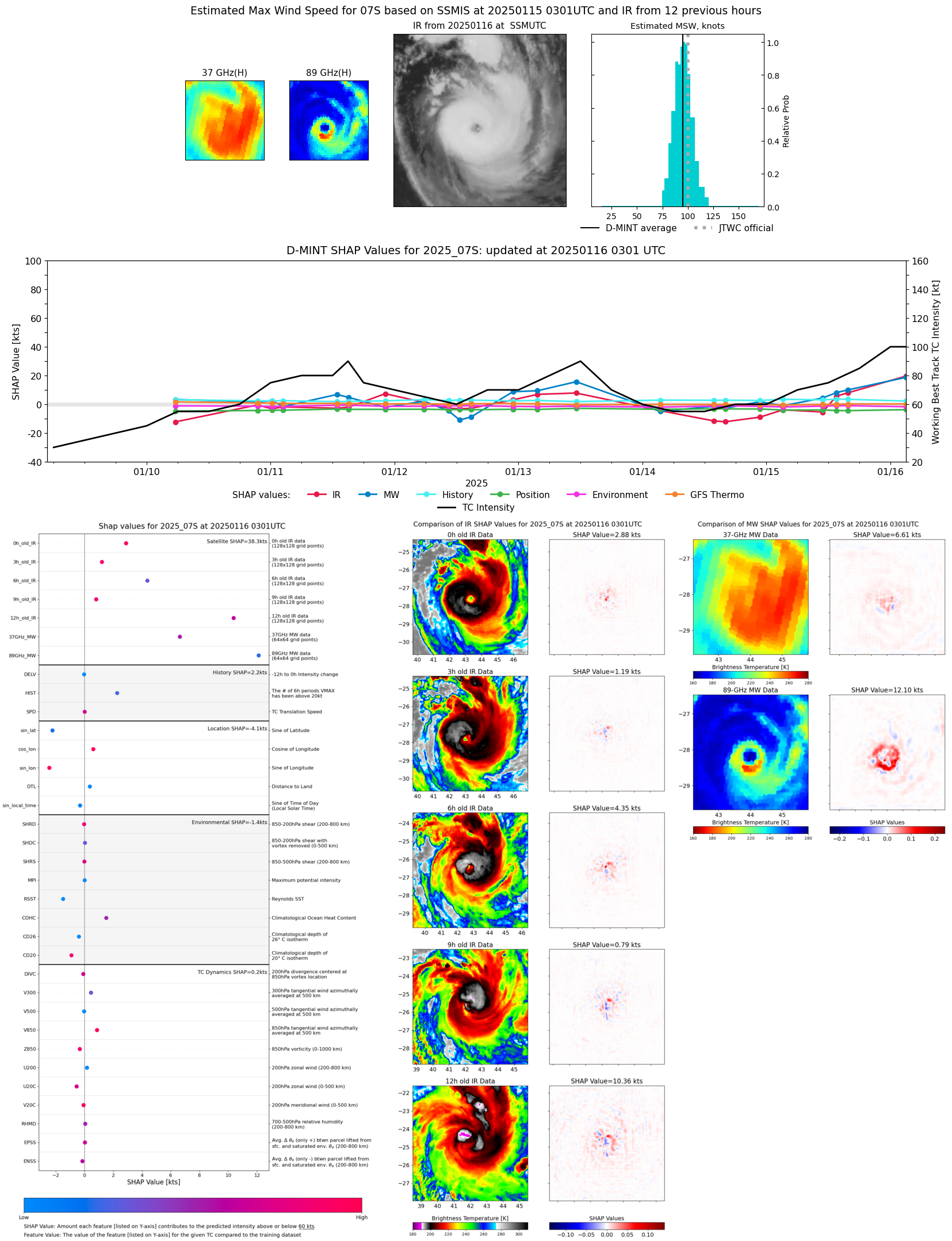 |
| 20250116 | 0051 UTC | SSMISF18 | NaN hPa | 92 kts | 87 kts | 98 kts | 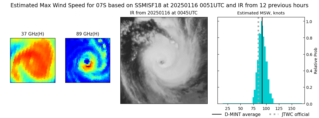 |
| 20250115 | 2217 UTC | ATMS-N20 | 953 hPa | 98 kts | 92 kts | 106 kts | 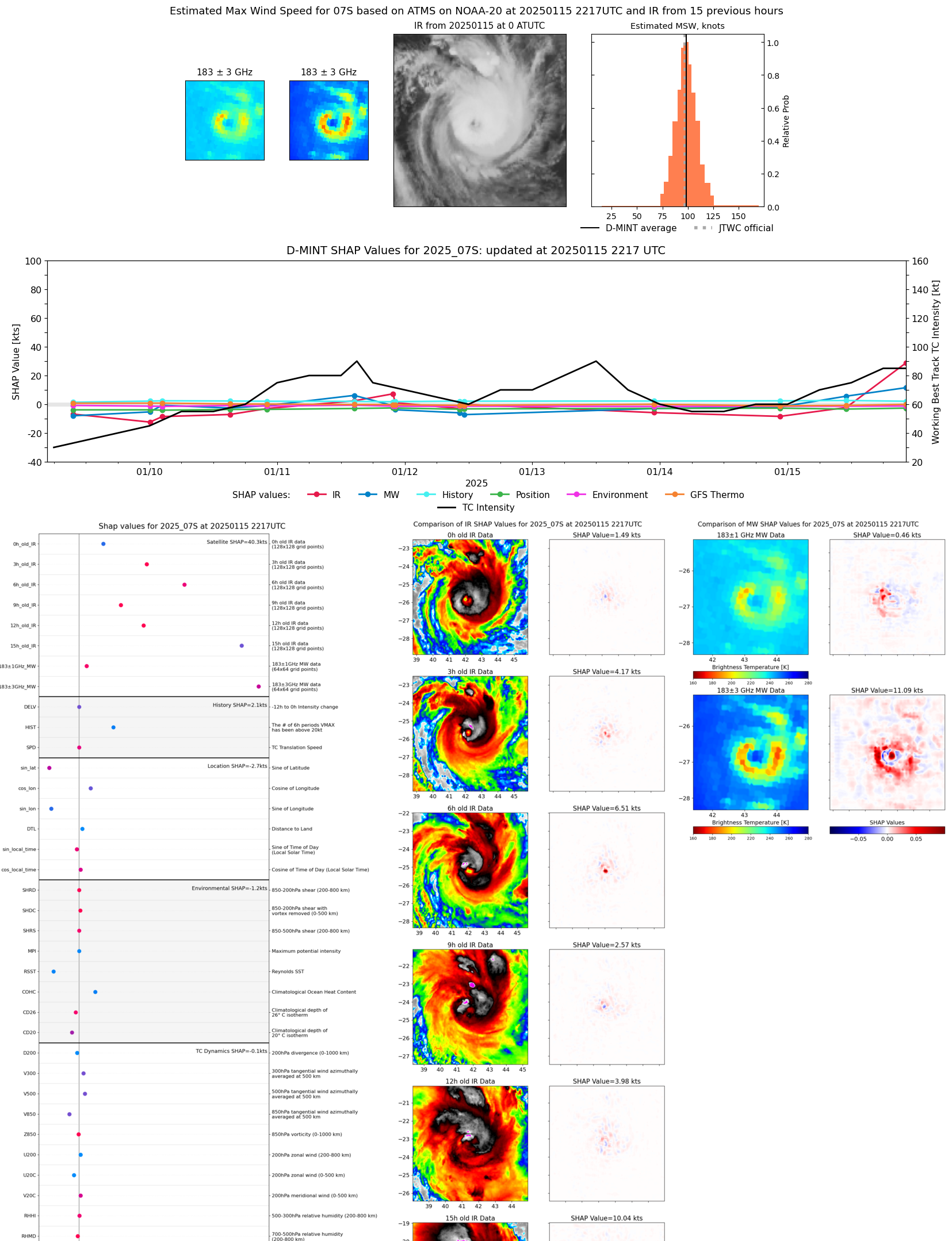 |
| 20250115 | 1612 UTC | SSMISF16 | 955 hPa | 79 kts | 71 kts | 86 kts | 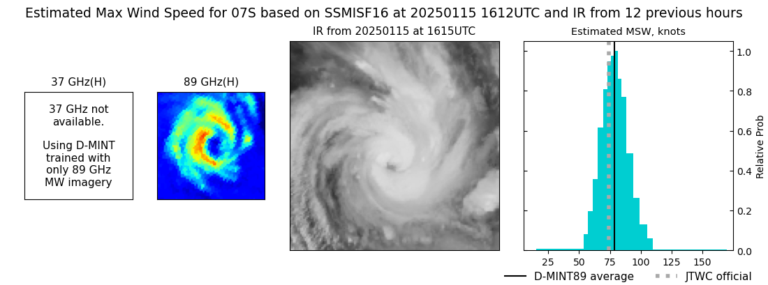 |
| 20250115 | 1544 UTC | SSMISF17 | 964 hPa | 76 kts | 69 kts | 83 kts | 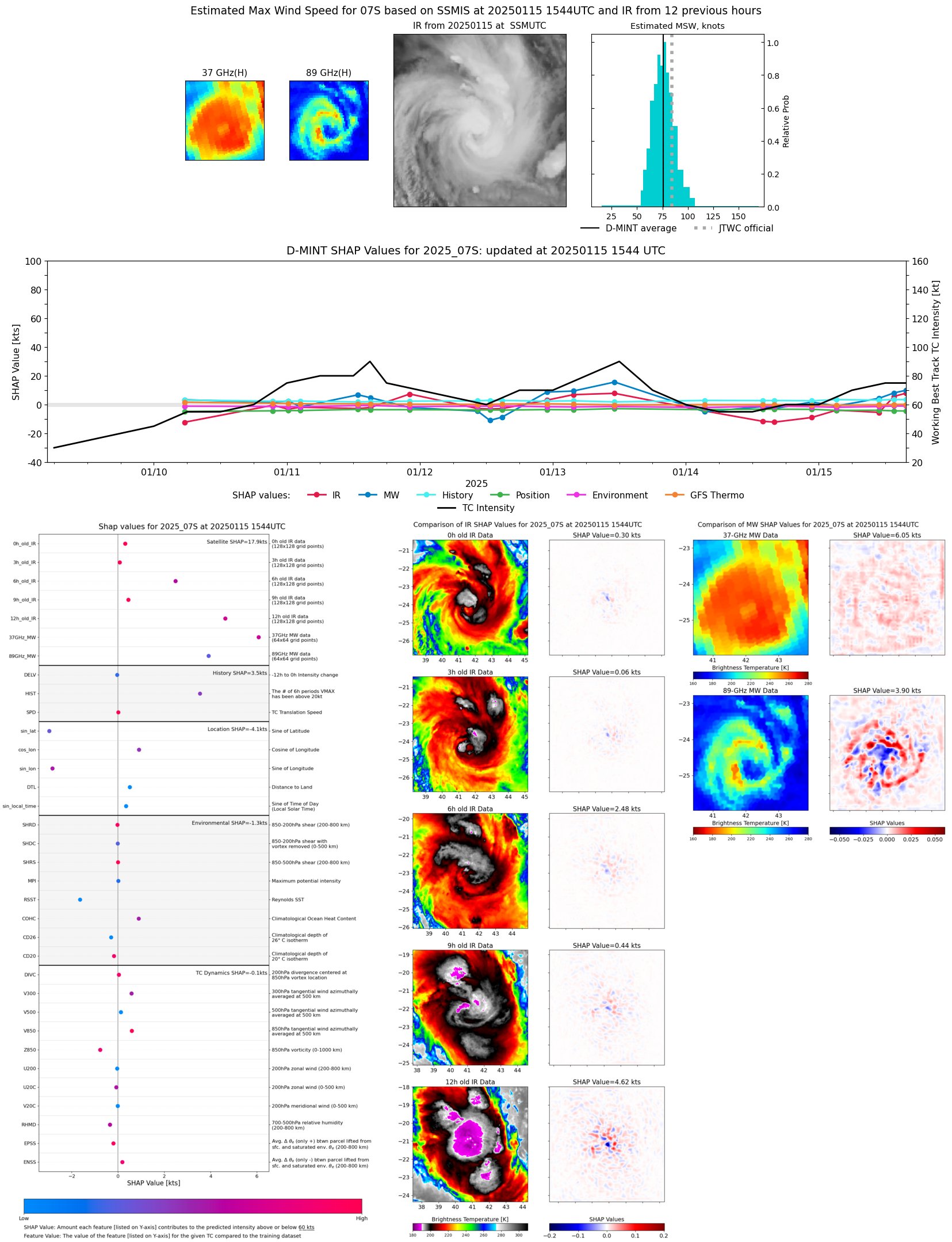 |
| 20250115 | 1334 UTC | SSMISF18 | 969 hPa | 72 kts | 64 kts | 79 kts | 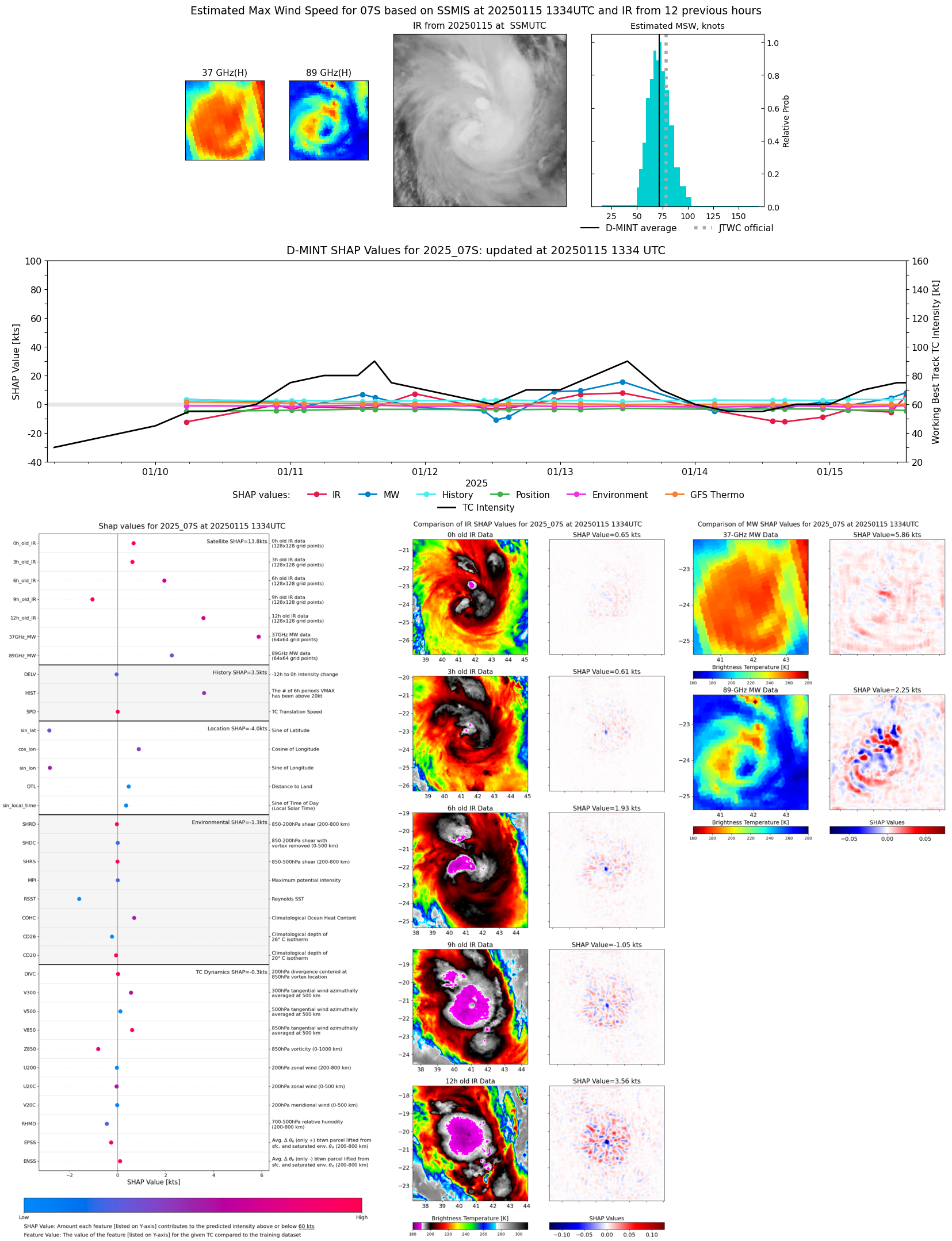 |
| 20250115 | 1103 UTC | ATMS-N20 | 977 hPa | 60 kts | 54 kts | 67 kts | 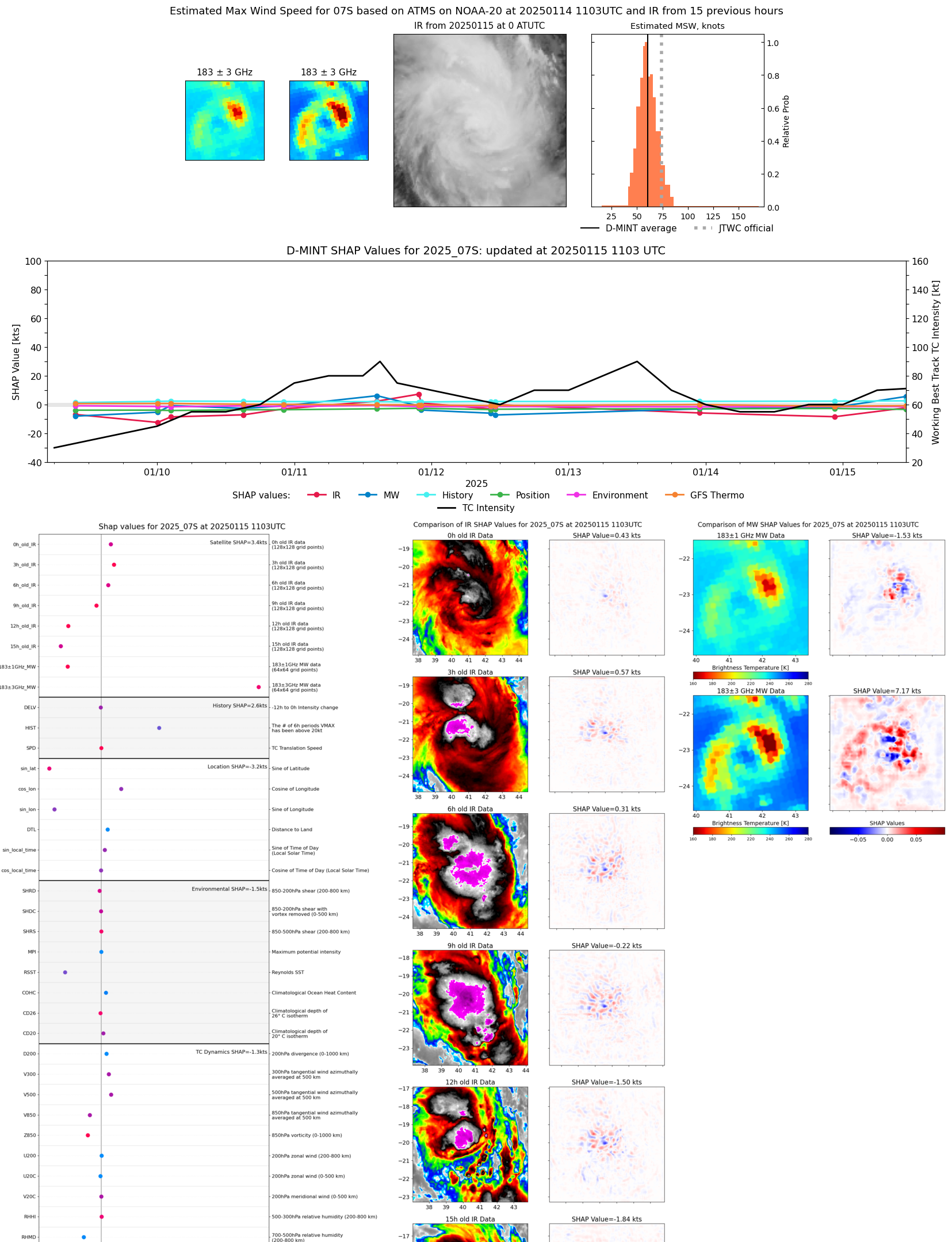 |
| 20250115 | 1054 UTC | AMSR2 | 978 hPa | 56 kts | 50 kts | 62 kts | 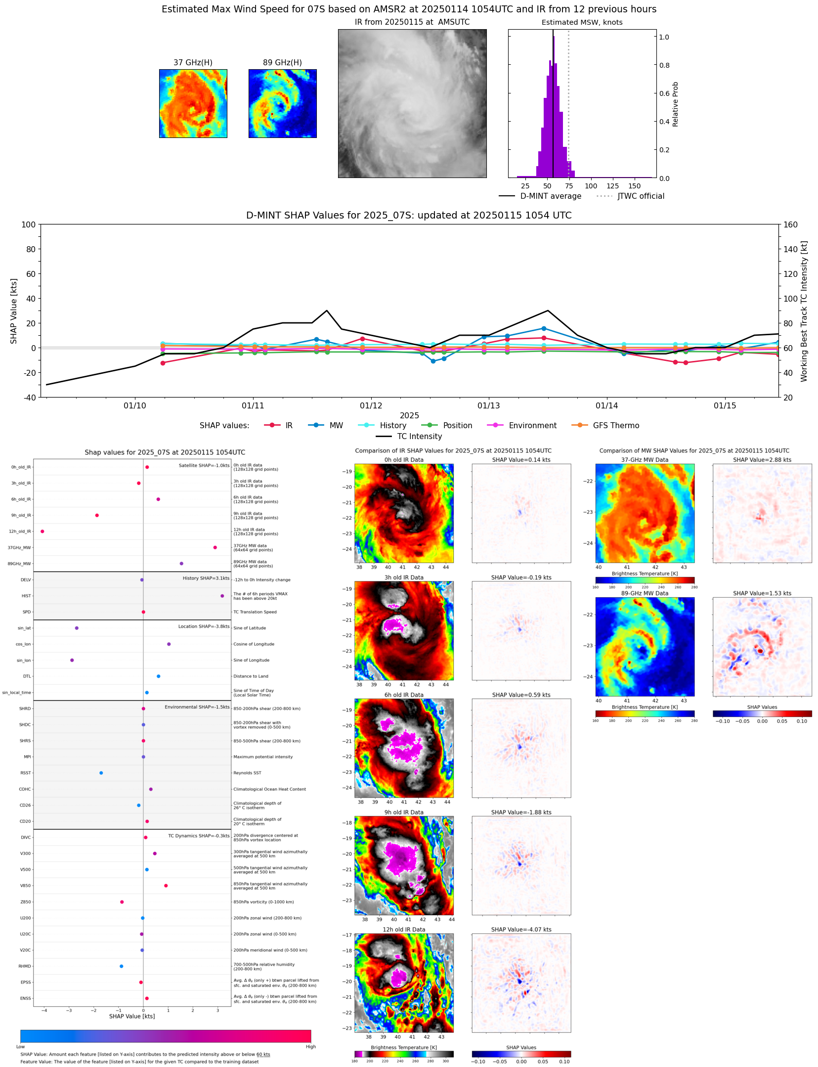 |
| 20250115 | 0513 UTC | GMI | 979 hPa | 63 kts | 57 kts | 69 kts | 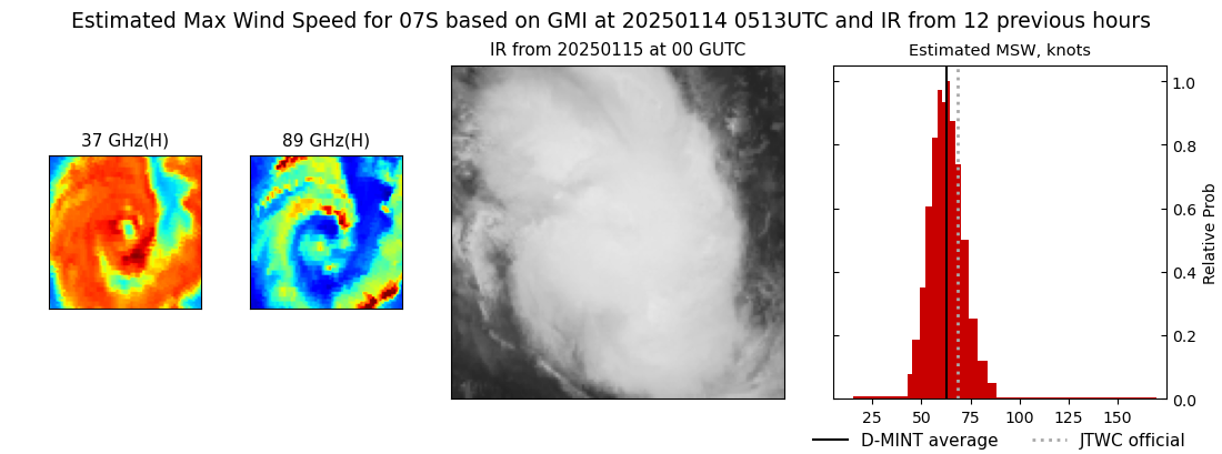 |
| 20250115 | 0340 UTC | SSMISF16 | 979 hPa | 51 kts | 45 kts | 58 kts | 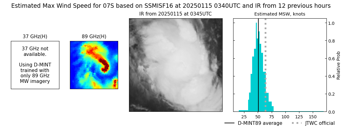 |
| 20250115 | 0313 UTC | SSMISF17 | 983 hPa | 52 kts | 46 kts | 59 kts | 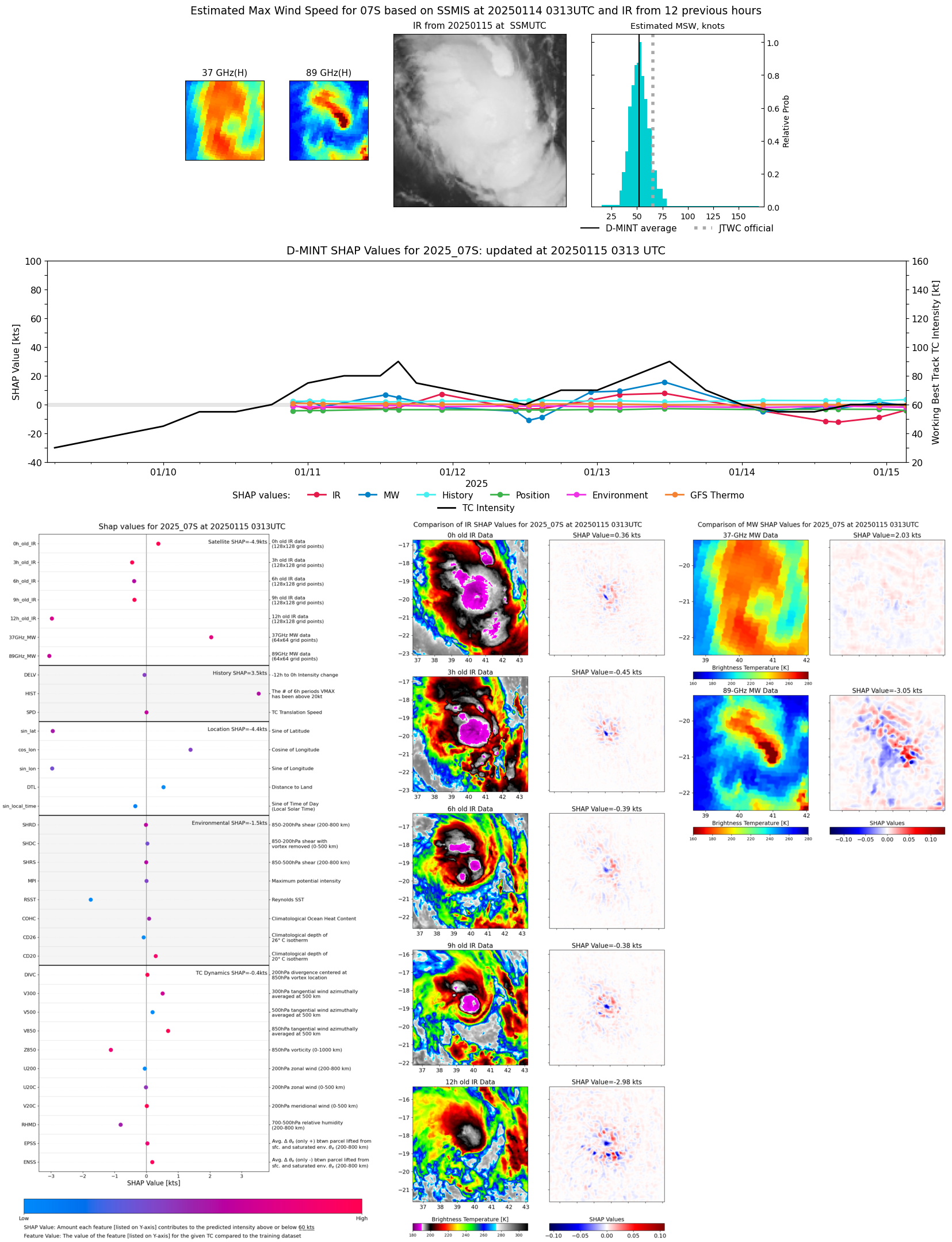 |
| 20250115 | 0103 UTC | SSMISF18 | NaN hPa | 43 kts | 38 kts | 49 kts | 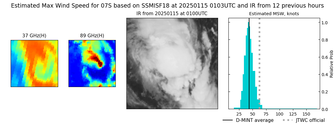 |
| 20250114 | 2244 UTC | AMSR2 | 992 hPa | 50 kts | 45 kts | 56 kts |  |
| 20250114 | 2235 UTC | ATMS-N20 | 992 hPa | 47 kts | 42 kts | 53 kts | 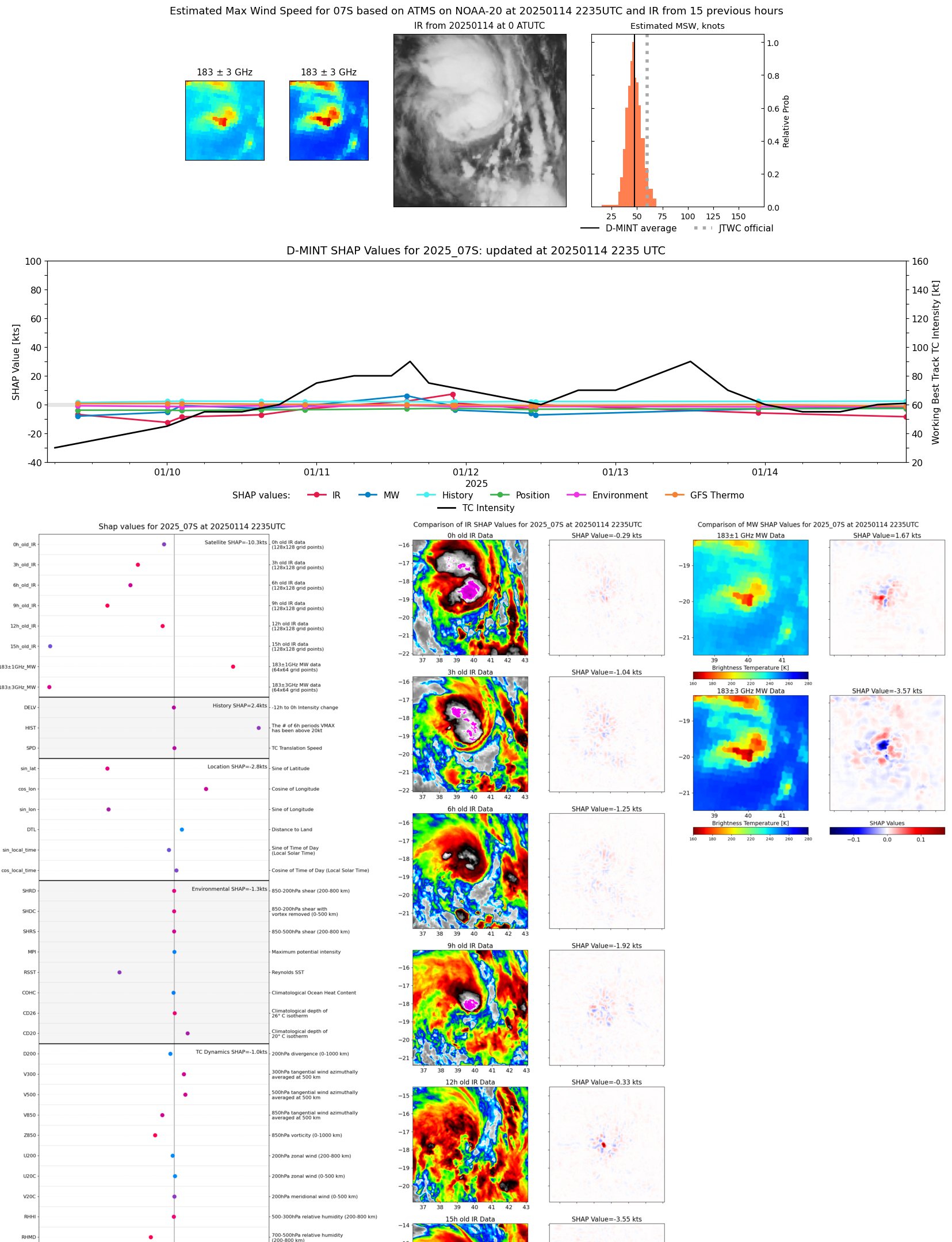 |
| 20250114 | 1600 UTC | SSMISF17 | 992 hPa | 43 kts | 38 kts | 49 kts | 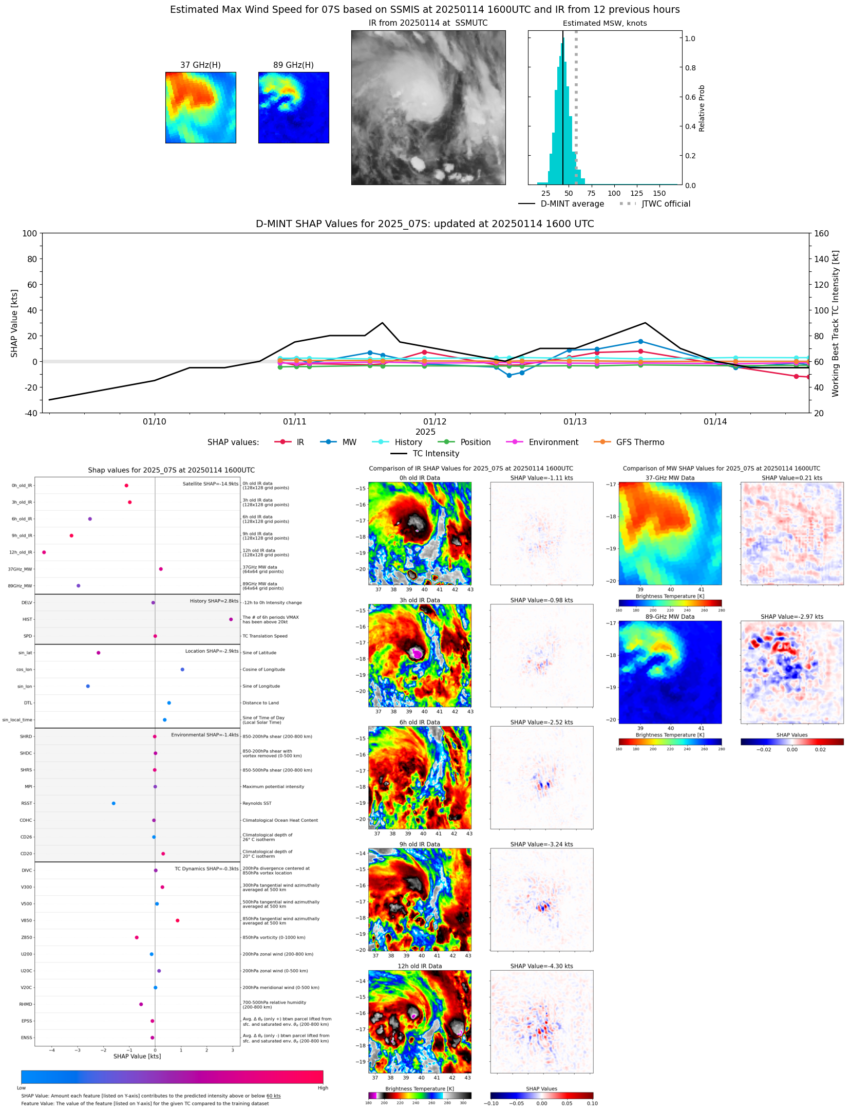 |
| 20250114 | 1417 UTC | TROPICS05 | 987 hPa | 47 kts | 40 kts | 54 kts | 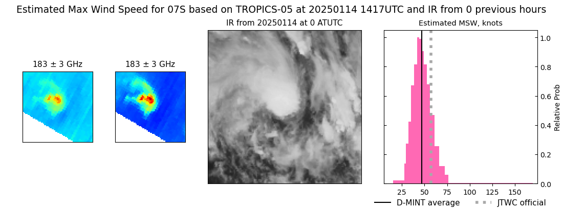 |
| 20250114 | 1350 UTC | SSMISF18 | 990 hPa | 45 kts | 40 kts | 51 kts |  |
| 20250114 | 0353 UTC | SSMISF16 | 989 hPa | 47 kts | 42 kts | 53 kts | 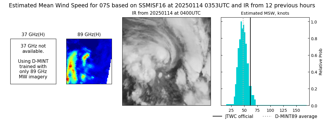 |
| 20250114 | 0326 UTC | SSMISF17 | 989 hPa | 48 kts | 42 kts | 54 kts | 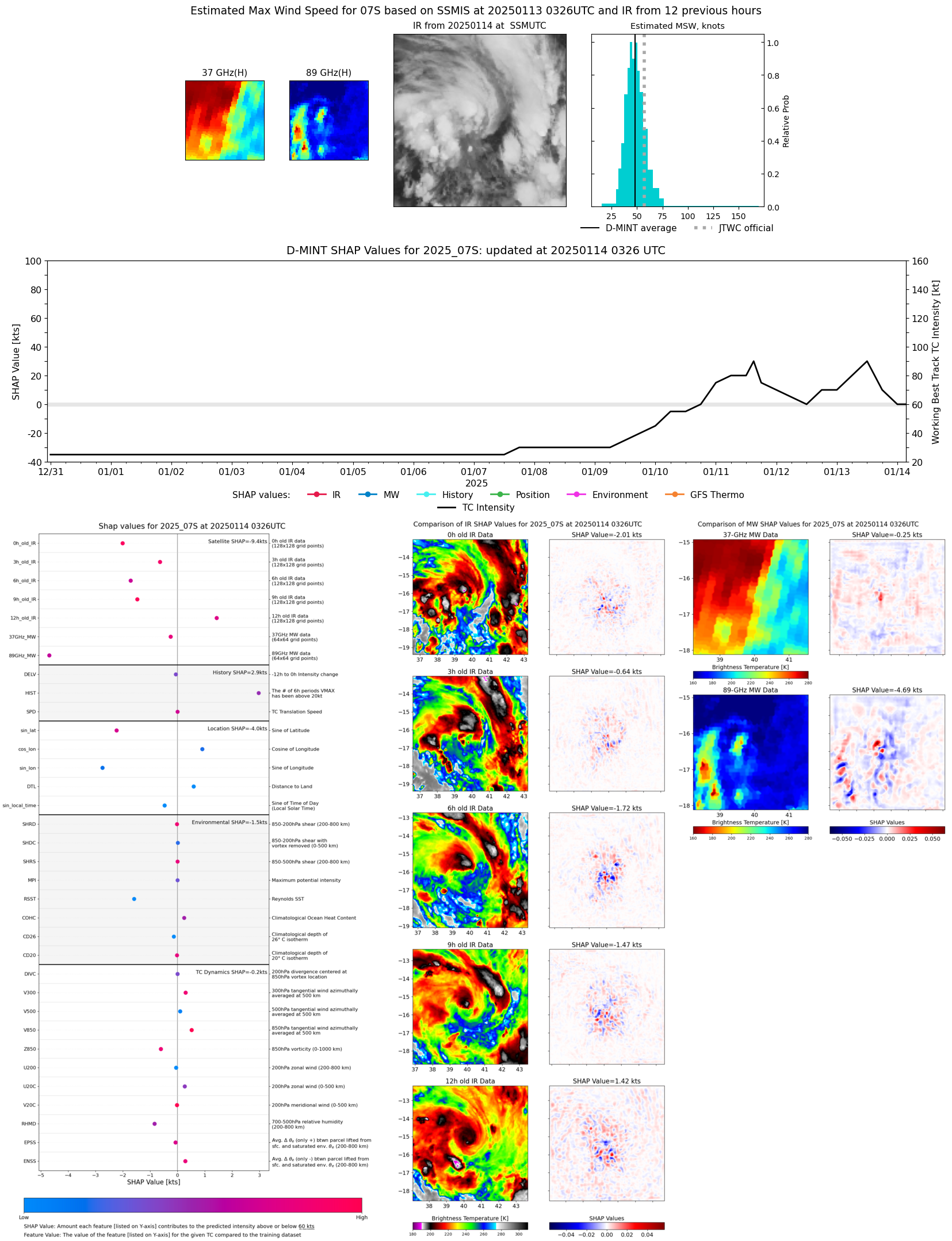 |
| 20250114 | 0115 UTC | SSMISF18 | NaN hPa | 45 kts | 39 kts | 52 kts | 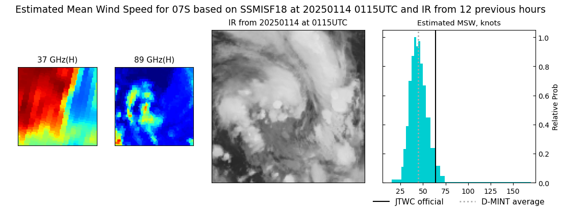 |
| 20250113 | 2252 UTC | ATMS-N20 | 990 hPa | 49 kts | 44 kts | 55 kts | 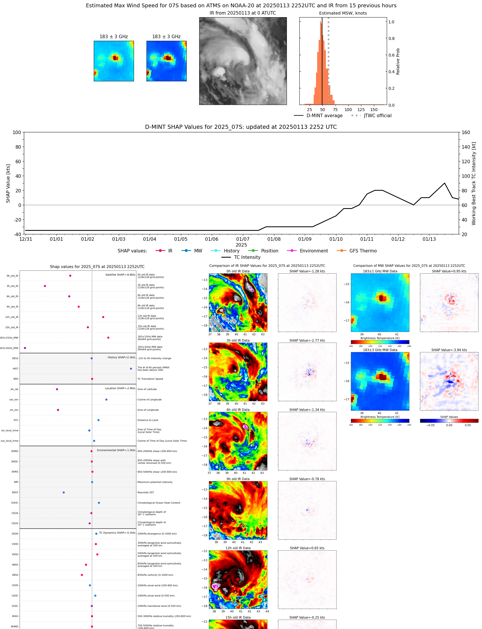 |
| 20250113 | 1109 UTC | AMSR2 | 964 hPa | 81 kts | 74 kts | 89 kts | 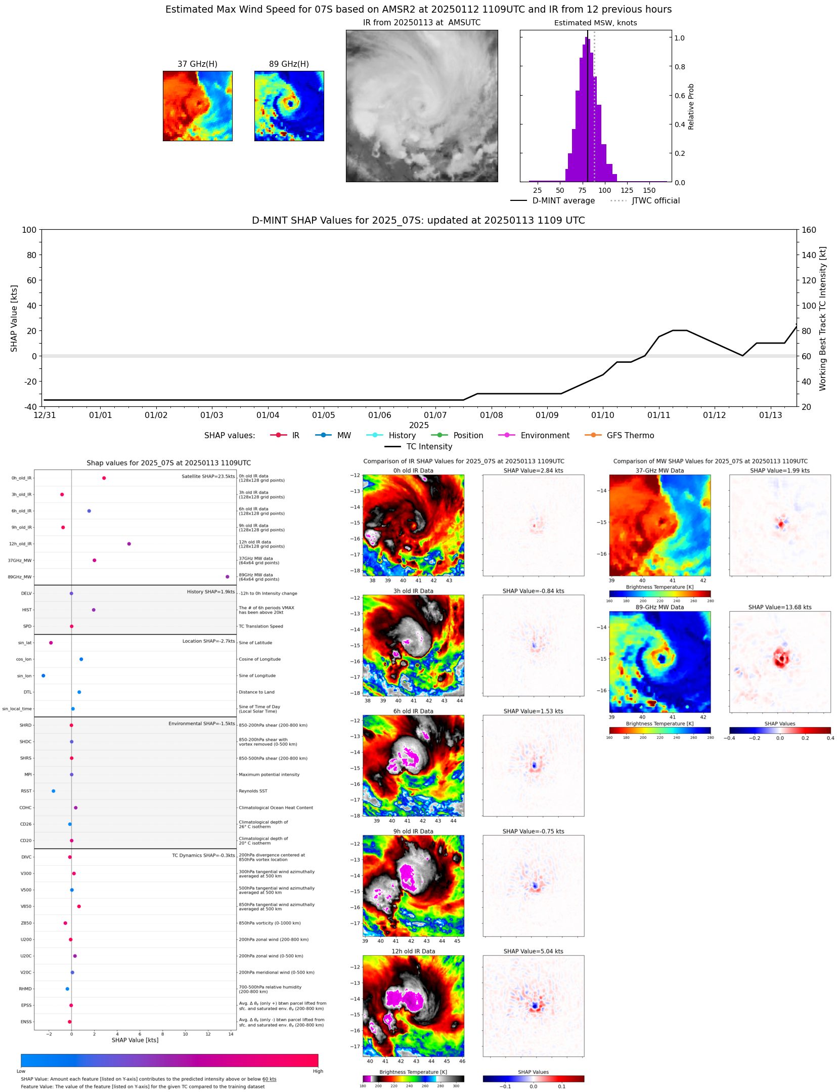 |
| 20250113 | 0341 UTC | SSMISF17 | 974 hPa | 74 kts | 67 kts | 81 kts | 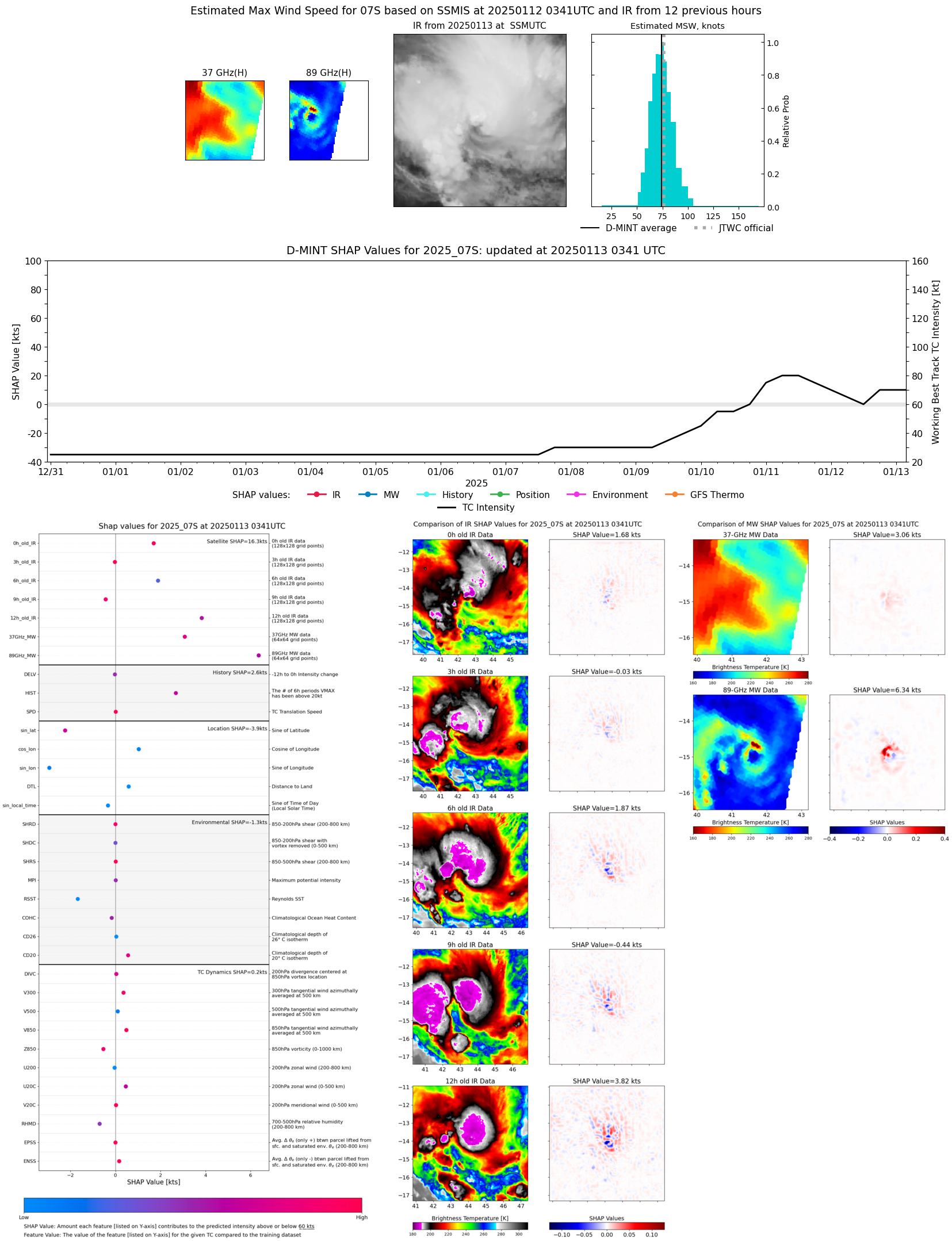 |
| 20250113 | 0213 UTC | TROPICS03 | 982 hPa | 62 kts | 56 kts | 68 kts | 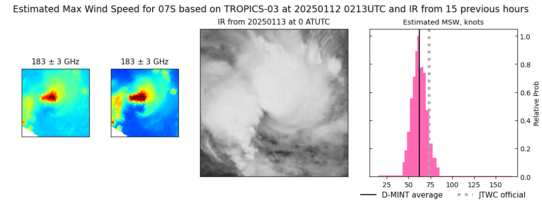 |
| 20250112 | 2256 UTC | AMSR2 | 980 hPa | 70 kts | 63 kts | 77 kts | 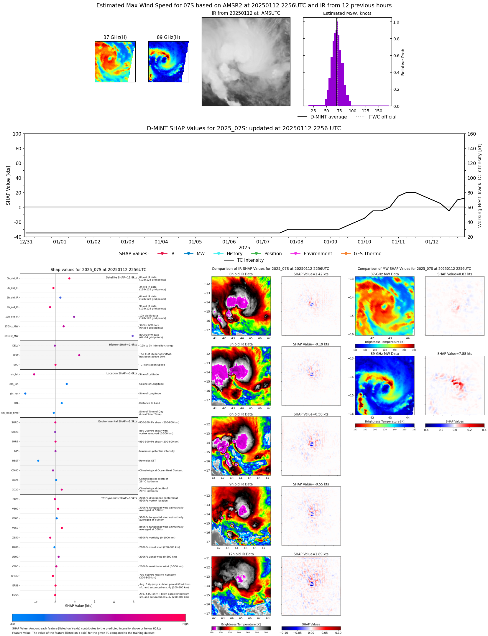 |
| 20250112 | 1514 UTC | SSMISF16 | 989 hPa | 42 kts | 36 kts | 49 kts | 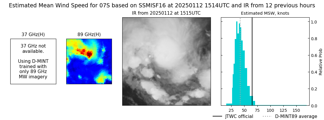 |
| 20250112 | 1449 UTC | SSMISF17 | 987 hPa | 47 kts | 41 kts | 53 kts | 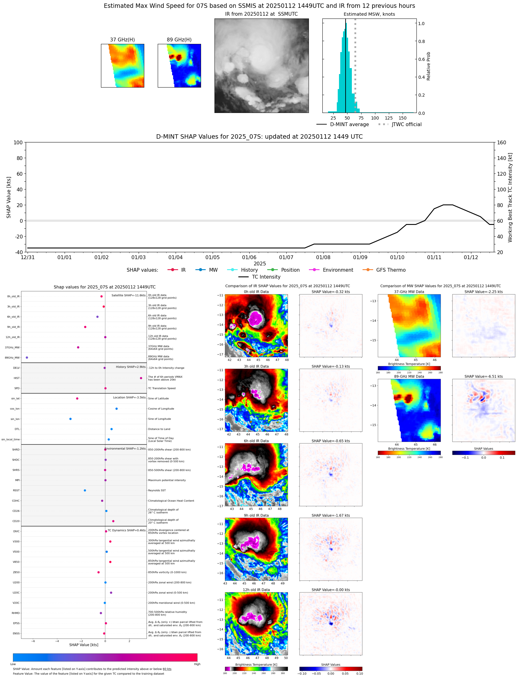 |
| 20250112 | 1238 UTC | SSMISF18 | 993 hPa | 44 kts | 38 kts | 51 kts | 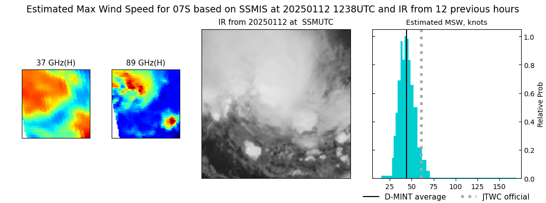 |
| 20250112 | 1109 UTC | TROPICS03 | 988 hPa | 50 kts | 44 kts | 57 kts | 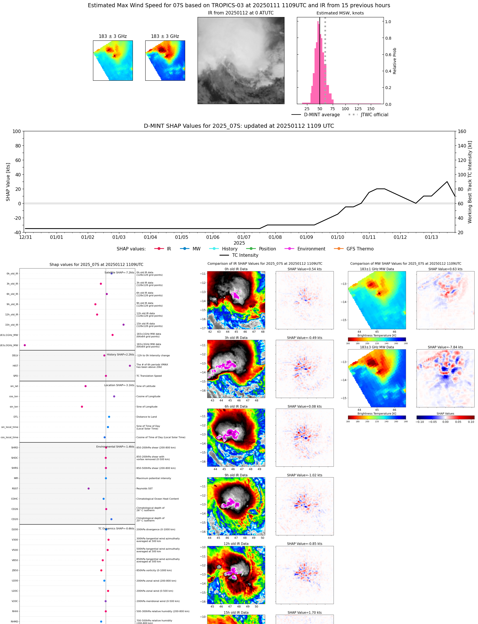 |
| 20250112 | 1026 UTC | AMSR2 | 990 hPa | 51 kts | 45 kts | 57 kts | 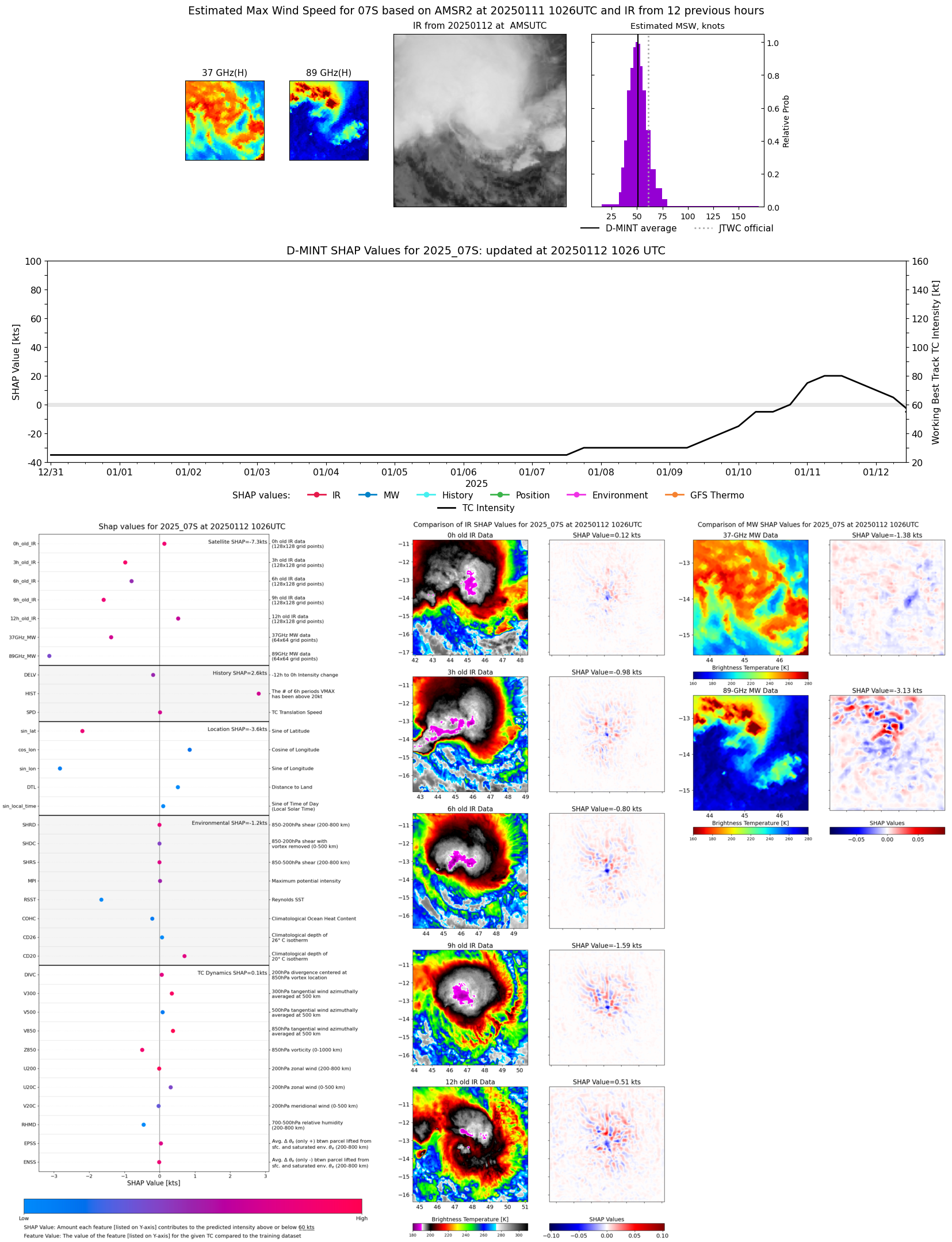 |
| 20250112 | 1022 UTC | ATMS-N20 | 994 hPa | 48 kts | 42 kts | 55 kts | 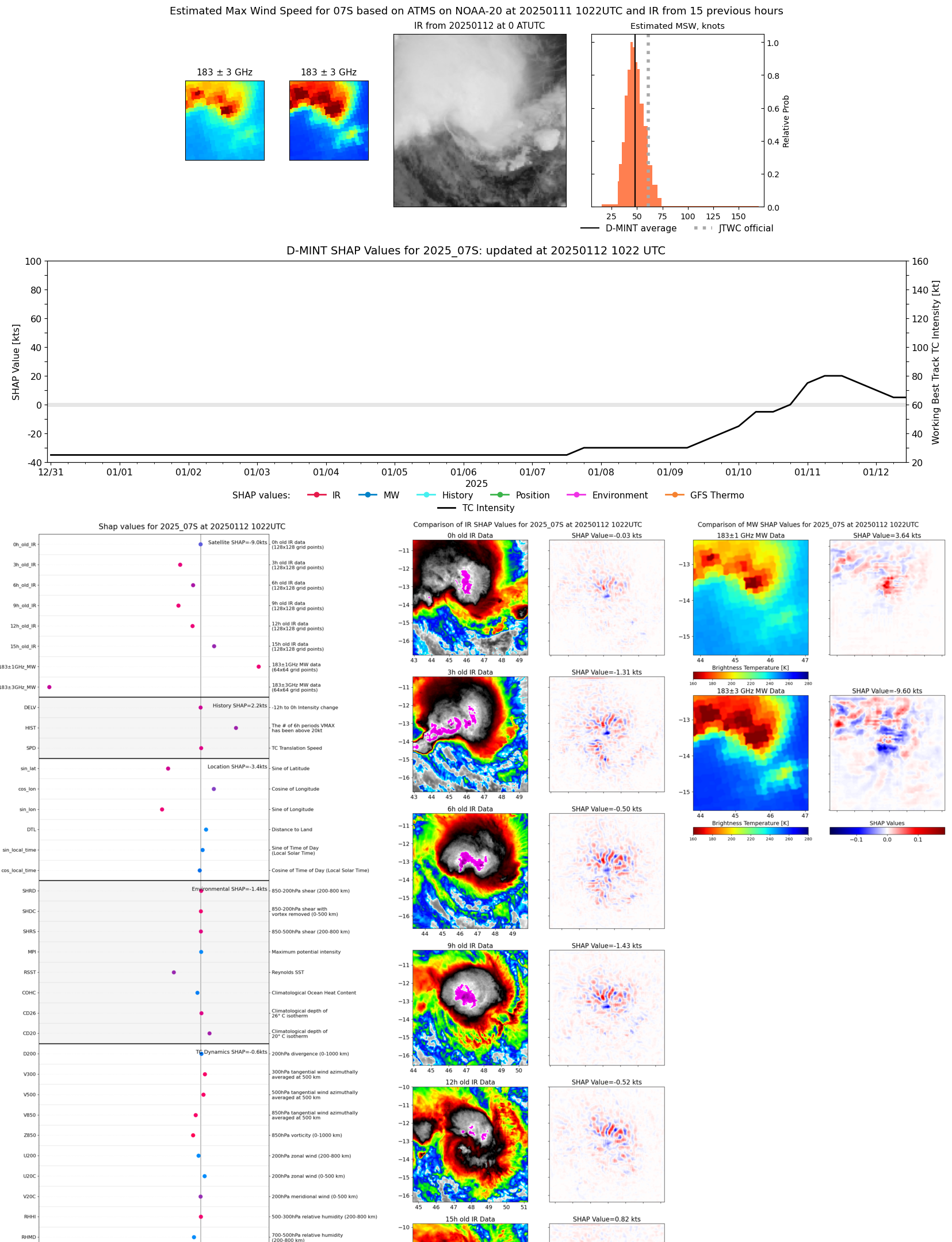 |
| 20250112 | 0543 UTC | GMI | 984 hPa | 62 kts | 56 kts | 69 kts | 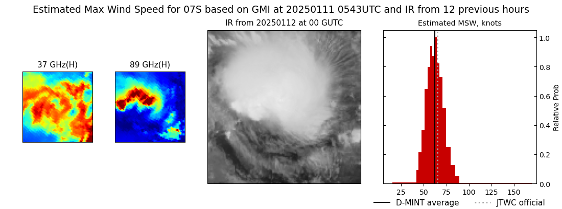 |
| 20250112 | 0238 UTC | SSMISF16 | 985 hPa | 48 kts | 41 kts | 55 kts | 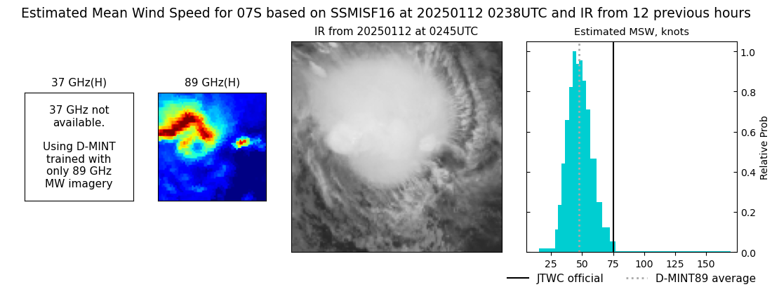 |
| 20250111 | 2213 UTC | ATMS-N20 | 984 hPa | 55 kts | 49 kts | 61 kts |  |
| 20250111 | 2211 UTC | AMSR2 | 988 hPa | 63 kts | 55 kts | 72 kts | 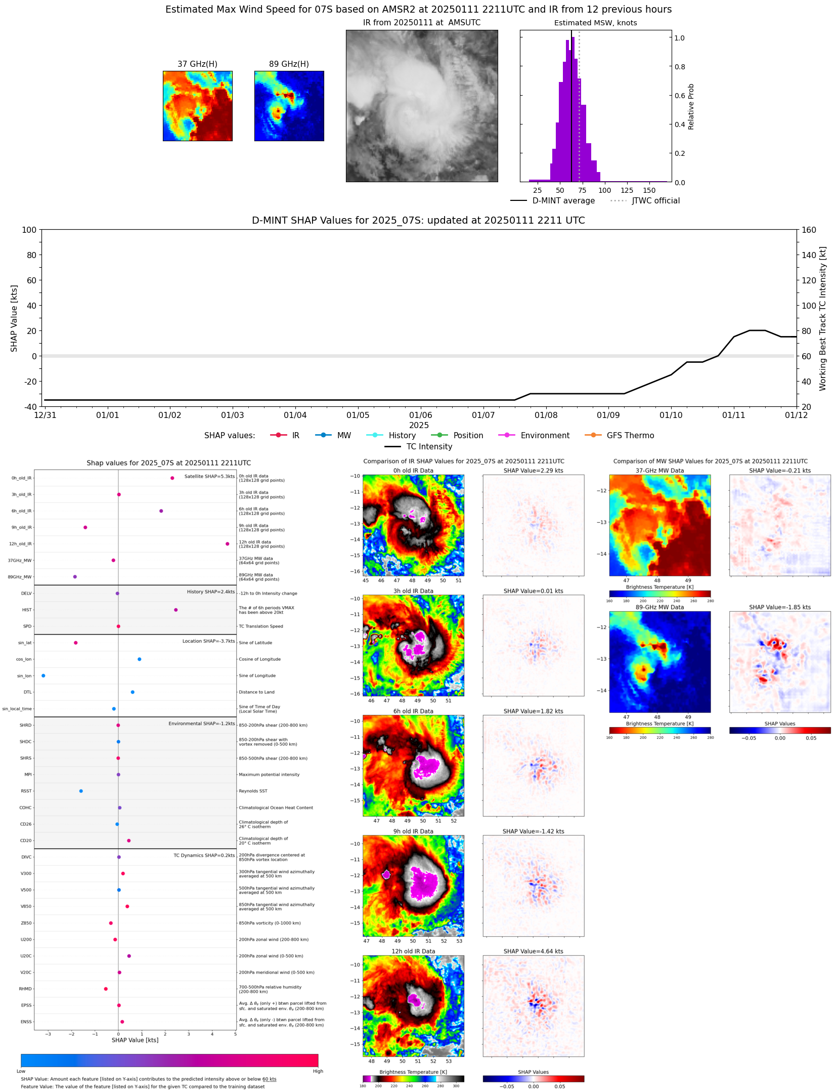 |
| 20250111 | 2148 UTC | ATMS-N20 | 981 hPa | 64 kts | 58 kts | 71 kts | 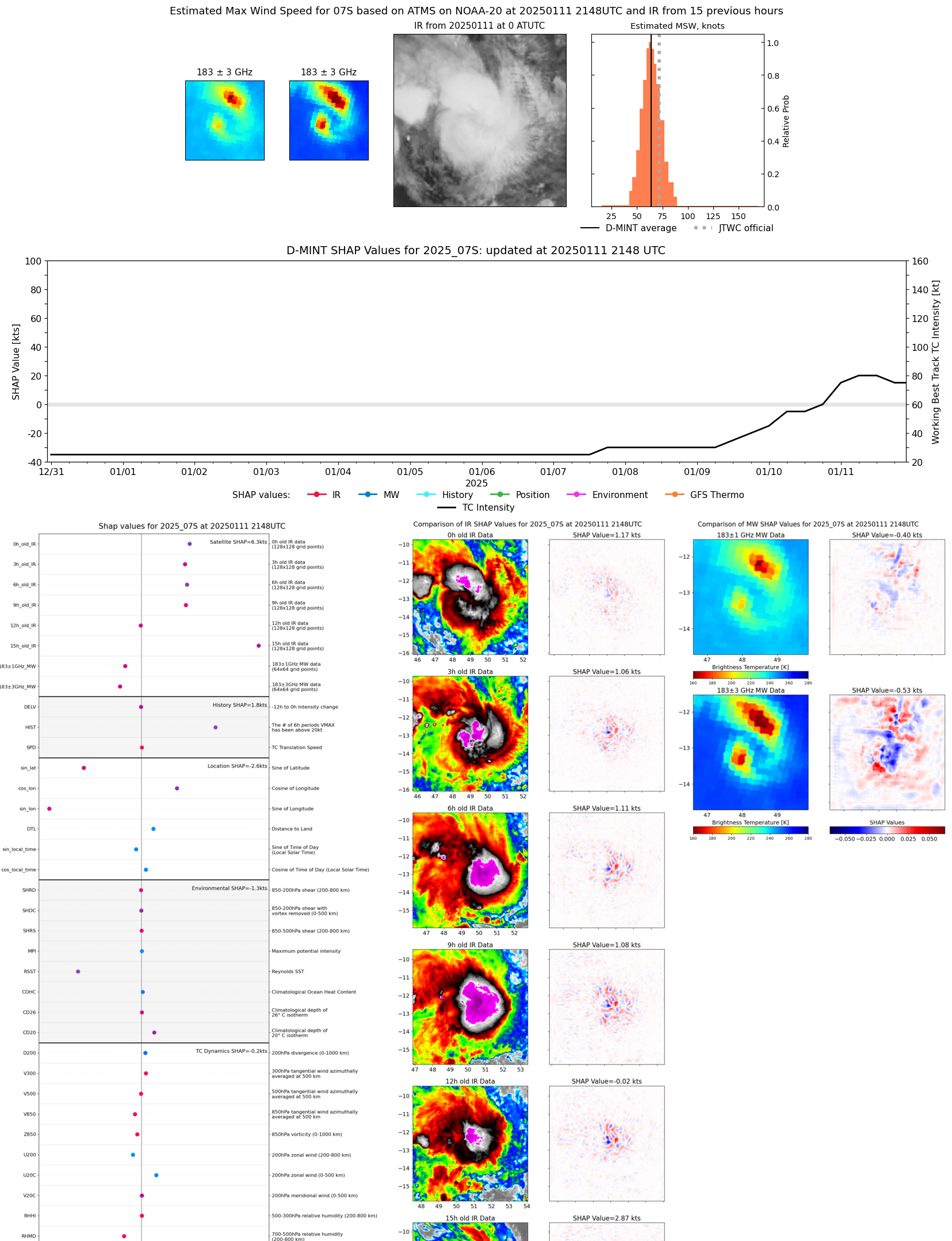 |
| 20250111 | 1528 UTC | SSMISF16 | 977 hPa | 59 kts | 52 kts | 66 kts | 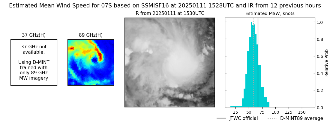 |
| 20250111 | 1503 UTC | SSMISF17 | 976 hPa | 61 kts | 54 kts | 69 kts | 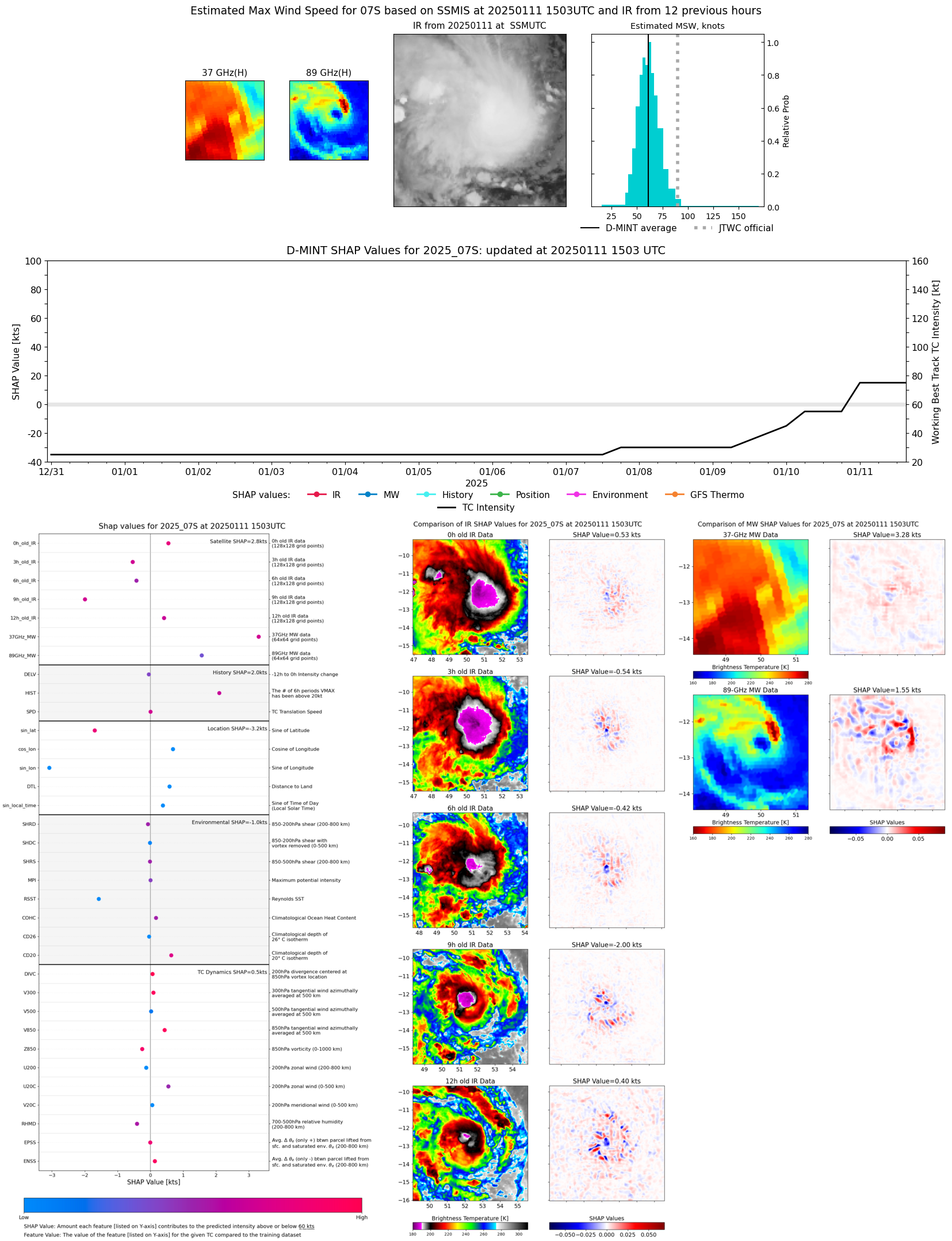 |
| 20250111 | 1429 UTC | TROPICS05 | 970 hPa | 67 kts | 61 kts | 74 kts | 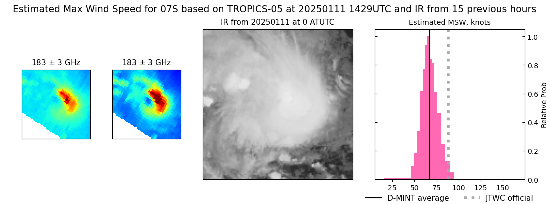 |
| 20250111 | 1251 UTC | SSMISF18 | 979 hPa | 62 kts | 56 kts | 69 kts | 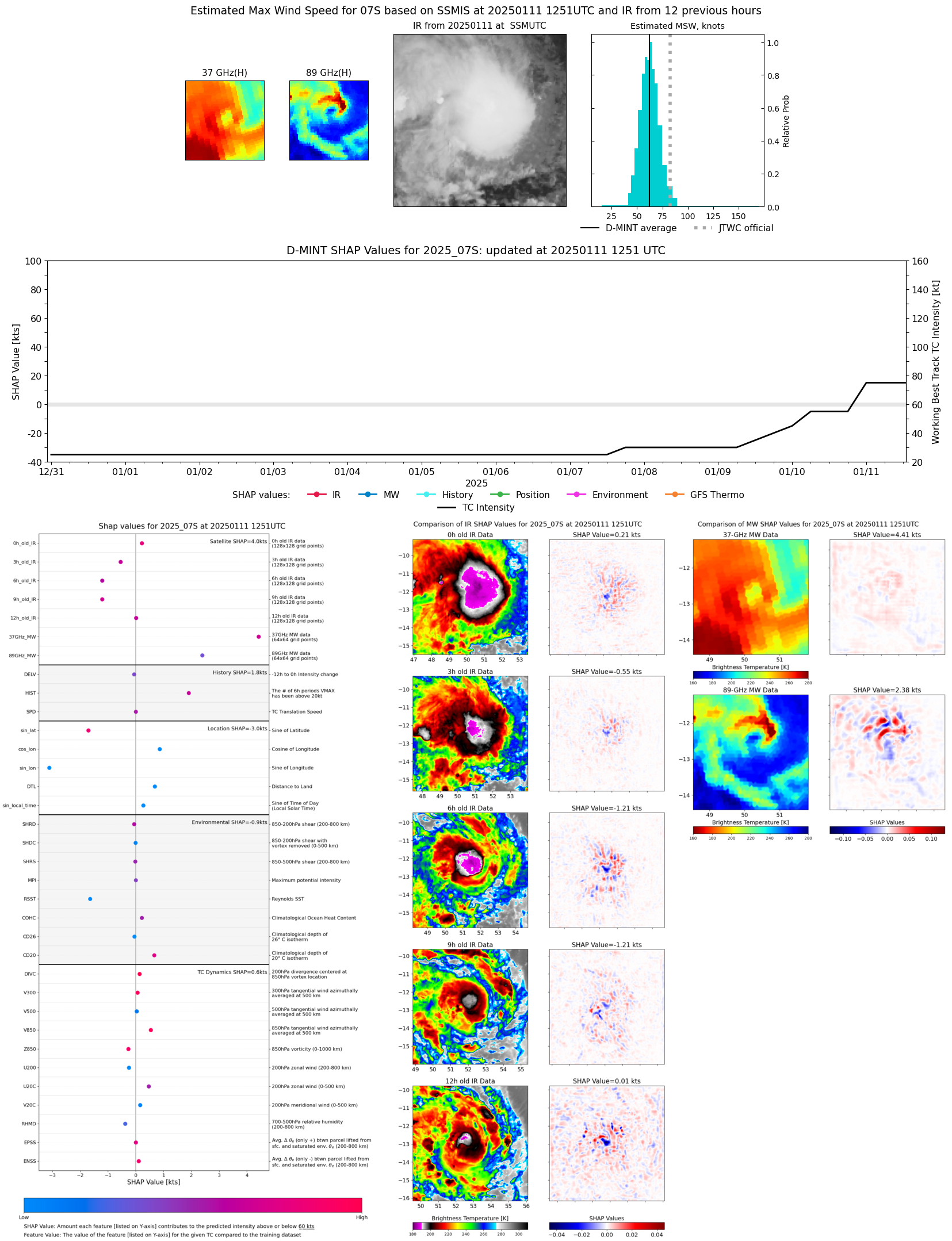 |
| 20250111 | 0251 UTC | SSMISF16 | 983 hPa | 62 kts | 55 kts | 69 kts | 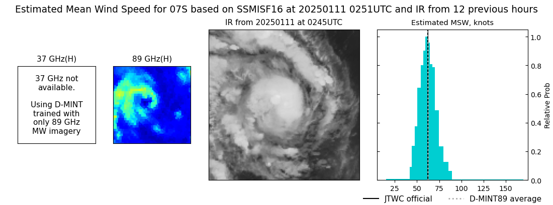 |
| 20250111 | 0226 UTC | SSMISF17 | 985 hPa | 54 kts | 48 kts | 61 kts | 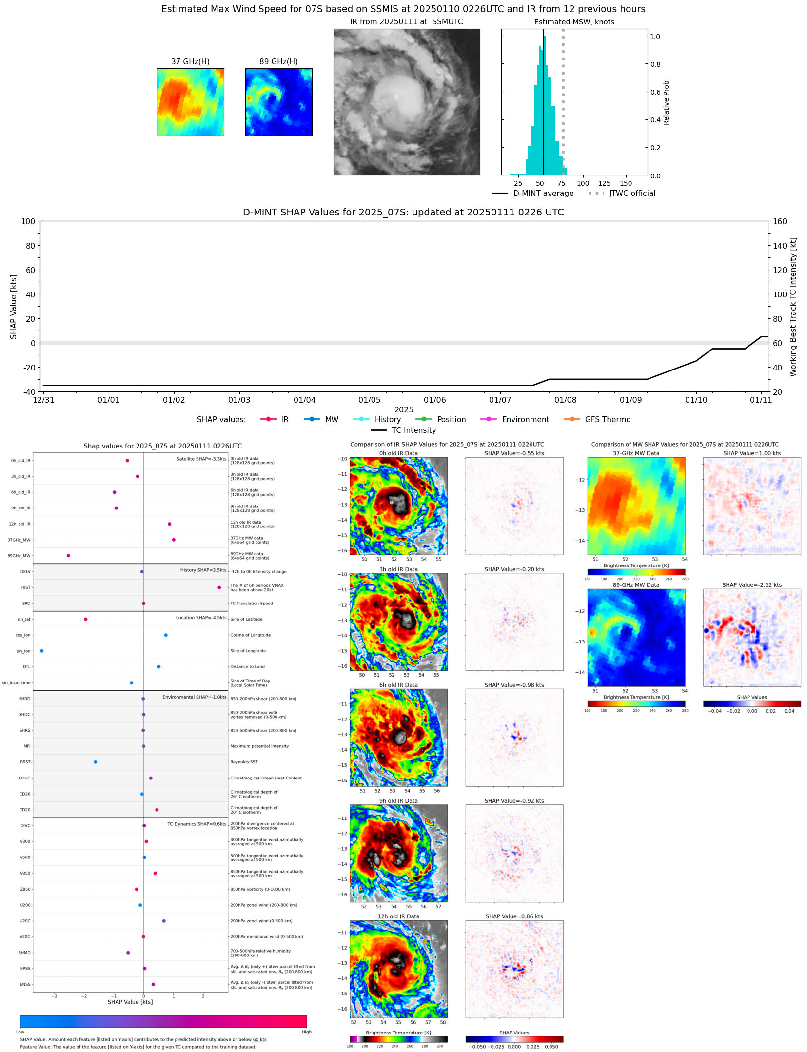 |
| 20250111 | 0015 UTC | SSMISF18 | 985 hPa | 57 kts | 51 kts | 63 kts | 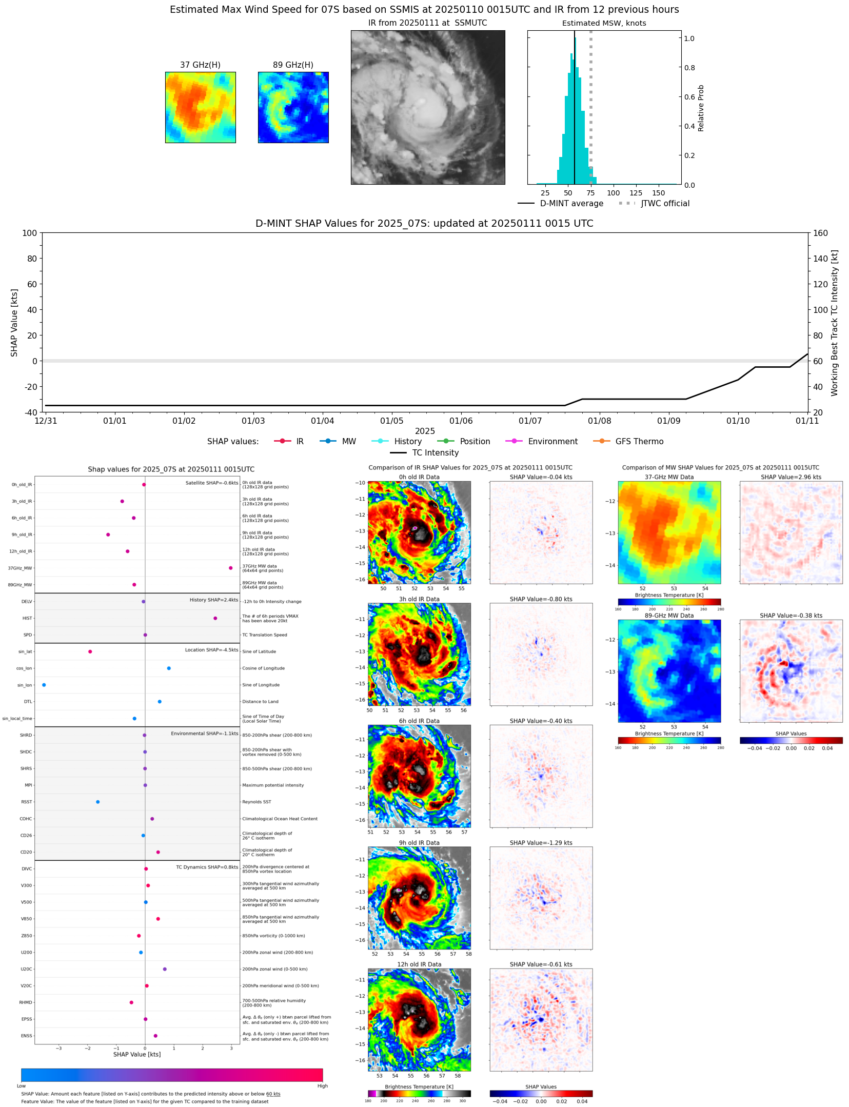 |
| 20250110 | 2207 UTC | ATMS-N20 | 986 hPa | 54 kts | 48 kts | 60 kts | 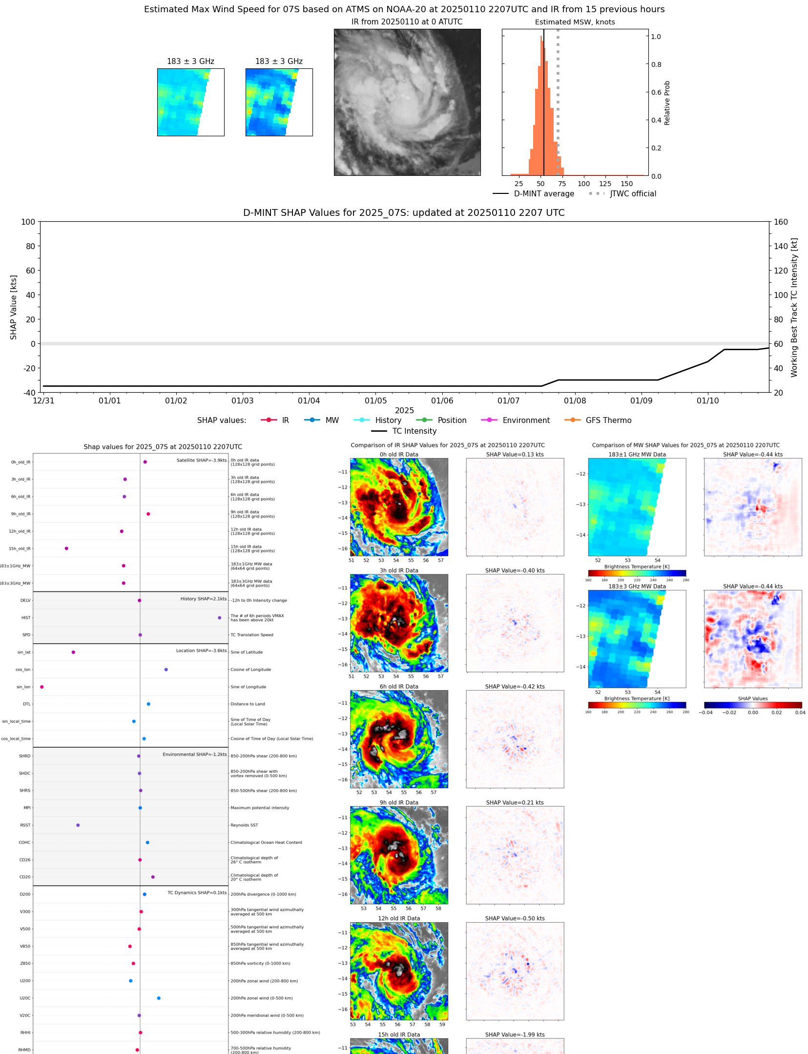 |
| 20250110 | 2129 UTC | AMSR2 | 990 hPa | 59 kts | 53 kts | 65 kts | 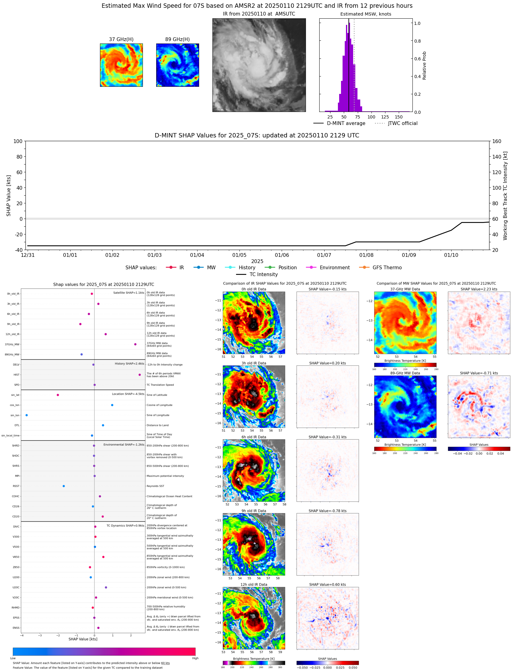 |
| 20250110 | 1507 UTC | TROPICS05 | 994 hPa | 48 kts | 43 kts | 54 kts | 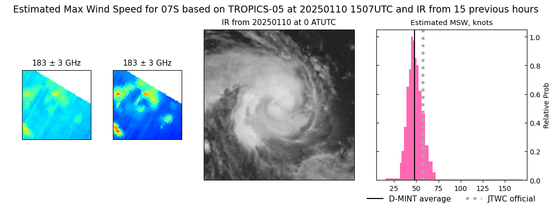 |
| 20250110 | 0533 UTC | GMI | 994 hPa | 50 kts | 45 kts | 55 kts | 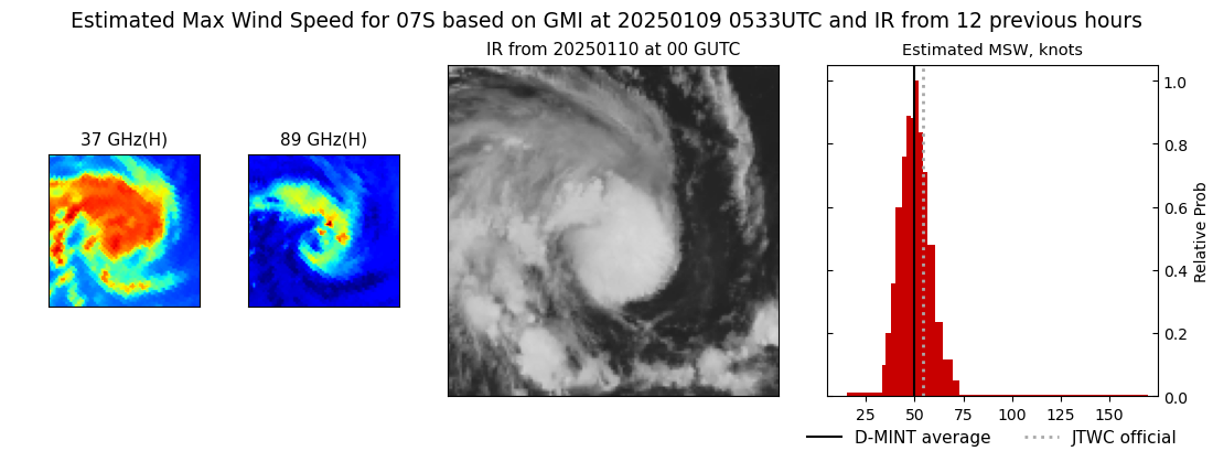 |
| 20250110 | 0224 UTC | TROPICS03 | 993 hPa | 48 kts | 43 kts | 54 kts | 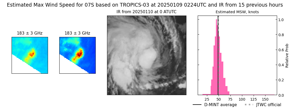 |
| 20250110 | 0004 UTC | TROPICS05 | 993 hPa | 40 kts | 35 kts | 46 kts | 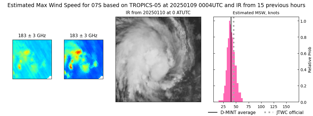 |
| 20250109 | 0938 UTC | ATMS-N20 | 995 hPa | 43 kts | 38 kts | 48 kts | 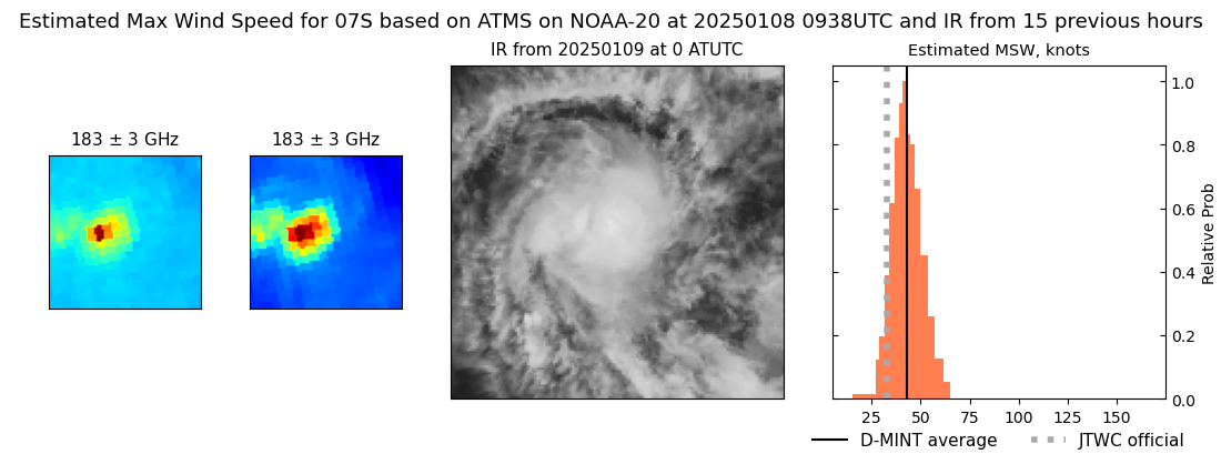 |
| 20250109 | 0301 UTC | TROPICS03 | 998 hPa | 37 kts | 33 kts | 42 kts | 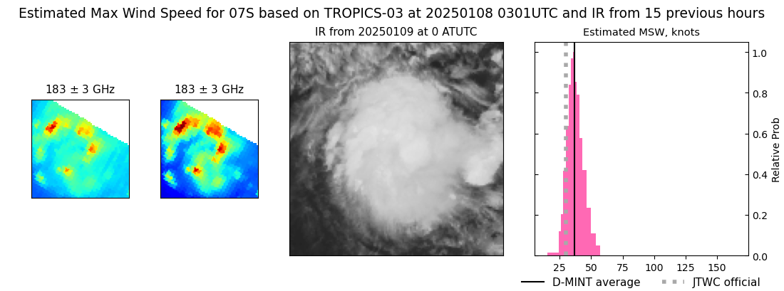 |
| 20250108 | 2104 UTC | ATMS-N20 | 1001 hPa | 29 kts | 26 kts | 33 kts | 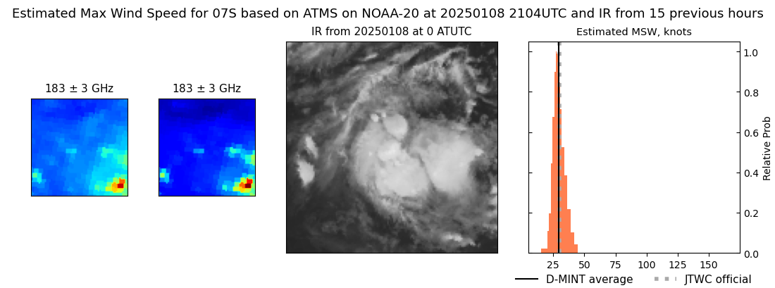 |
| 20241230 | 2235 UTC | SSMISF16 | NaN hPa | 20 kts | 17 kts | 23 kts |  |
| 20241230 | 2216 UTC | SSMISF17 | NaN hPa | 19 kts | 16 kts | 23 kts |  |
| 20241230 | 2001 UTC | SSMISF18 | NaN hPa | 22 kts | 18 kts | 25 kts |  |
| 20241230 | 1829 UTC | AMSR2 | NaN hPa | 23 kts | 20 kts | 27 kts |  |
| 20241230 | 0851 UTC | SSMISF18 | NaN hPa | 20 kts | 17 kts | 24 kts |  |
| 20241230 | 0601 UTC | AMSR2 | NaN hPa | 17 kts | 15 kts | 20 kts |  |
| 20241229 | 2228 UTC | SSMISF17 | NaN hPa | 17 kts | 14 kts | 19 kts |  |