|
||

 |
D-MINT HISTORY FILE for 2025_08E
| Date | Time | MW Sensor | MSLP | Vmax (30th-70th percentile average) | Vmax 25th percentile | Vmax 75th percentile | Image |
| 20250813 | 1703 UTC | GMI | 1014 hPa | 29 kts | 27 kts | 31 kts | 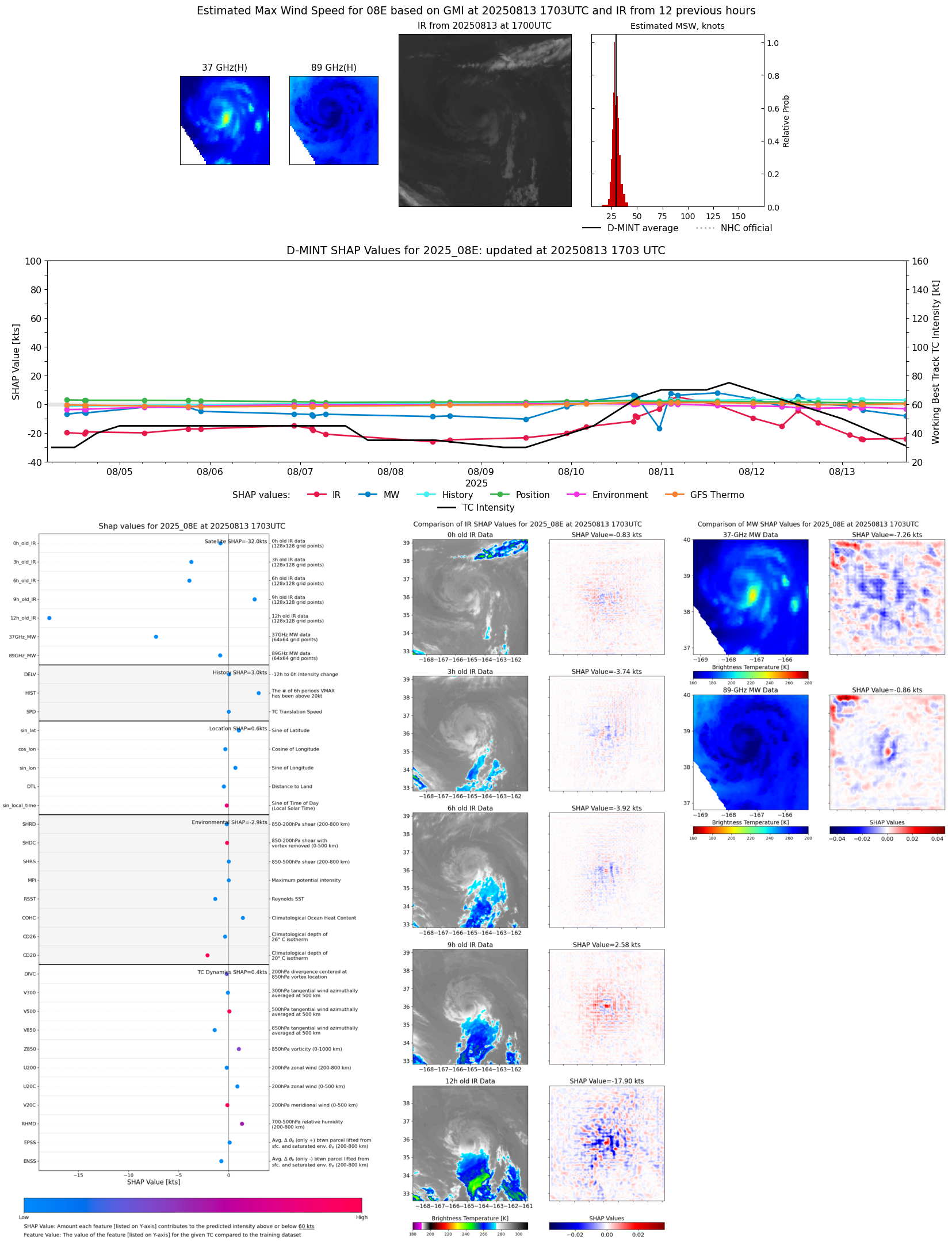 |
| 20250813 | 1303 UTC | AMSR2 | 1014 hPa | 30 kts | 28 kts | 33 kts | 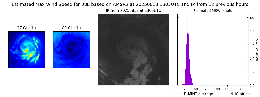 |
| 20250813 | 0533 UTC | SSMISF16 | 1009 hPa | 33 kts | 30 kts | 37 kts | 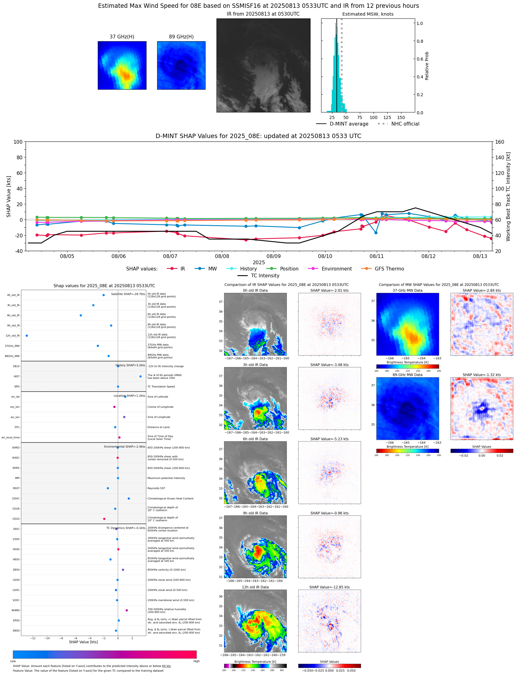 |
| 20250813 | 0533 UTC | SSMISF16 | 1010 hPa | 34 kts | 30 kts | 37 kts |  |
| 20250813 | 0507 UTC | SSMISF17 | 1009 hPa | 35 kts | 32 kts | 40 kts |  |
| 20250813 | 0202 UTC | SSMISF18 | 1007 hPa | 39 kts | 35 kts | 44 kts | 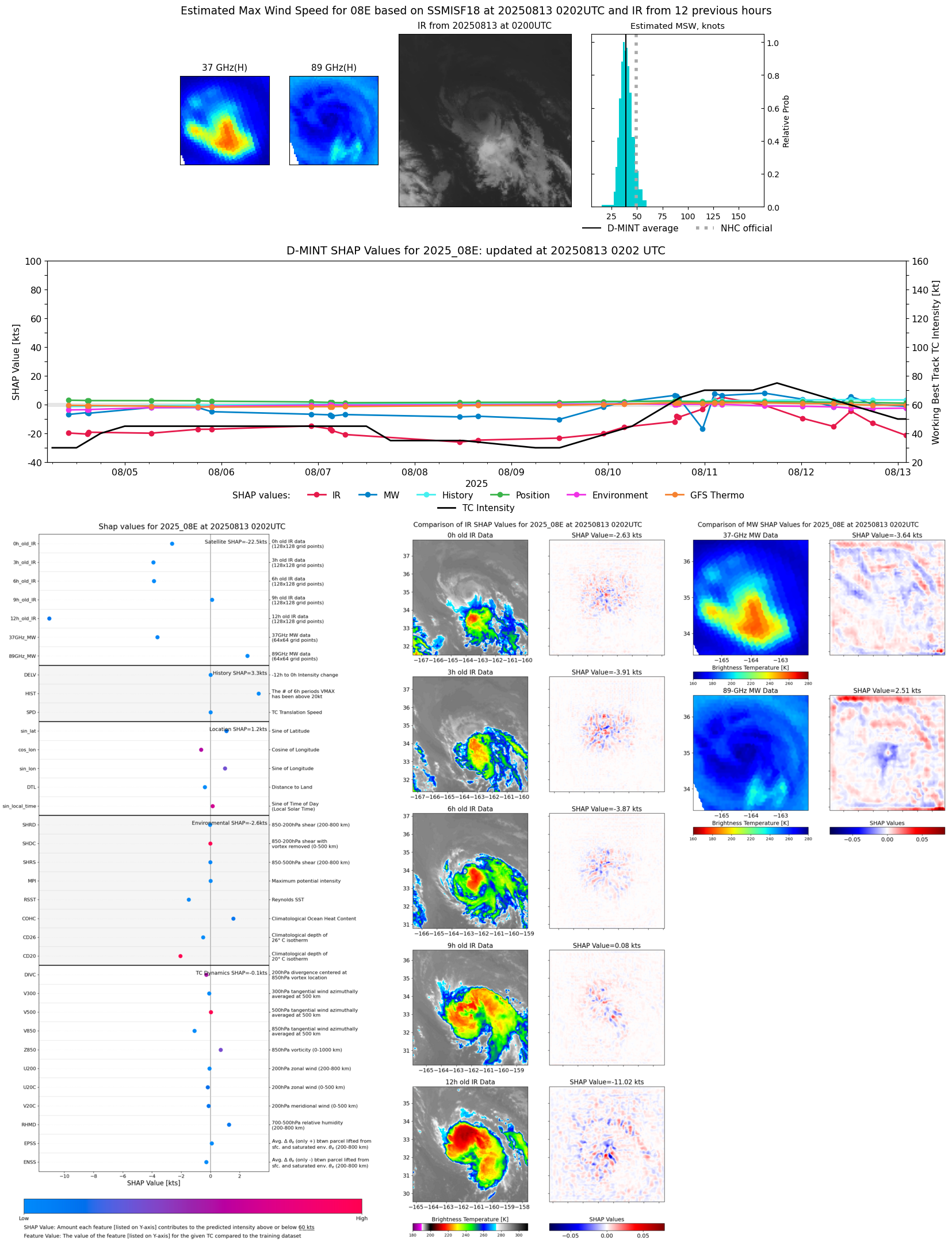 |
| 20250812 | 2129 UTC | AWS | 1006 hPa | 47 kts | 43 kts | 52 kts | 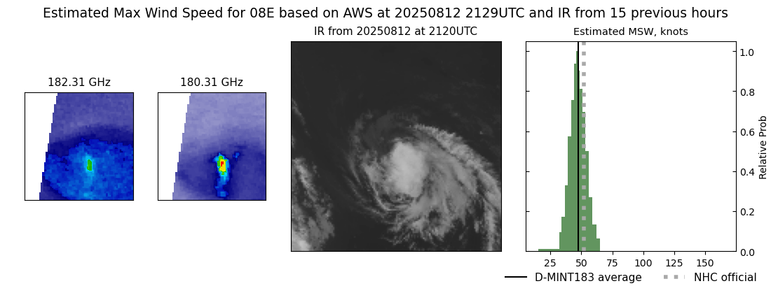 |
| 20250812 | 1919 UTC | TROPICS03 | 1005 hPa | 46 kts | 41 kts | 51 kts | 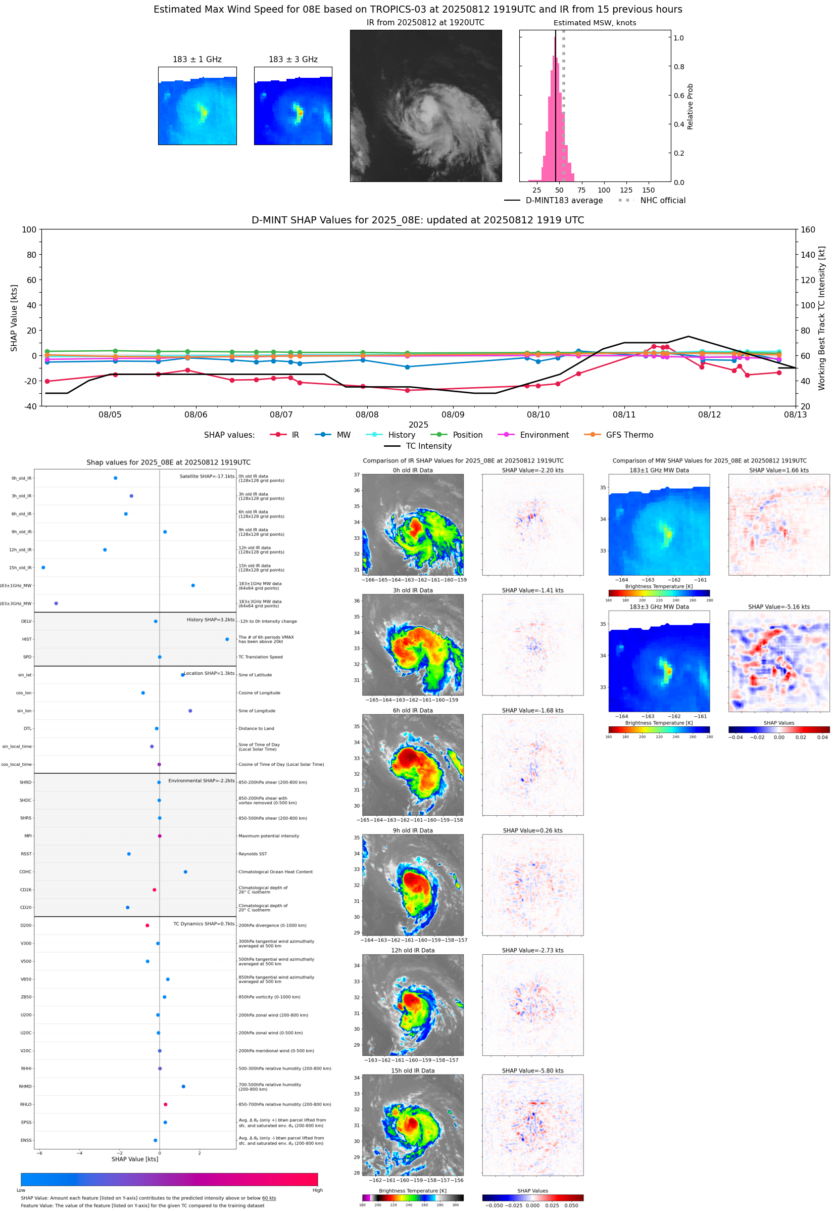 |
| 20250812 | 1810 UTC | SSMISF16 | 1004 hPa | 53 kts | 48 kts | 58 kts | 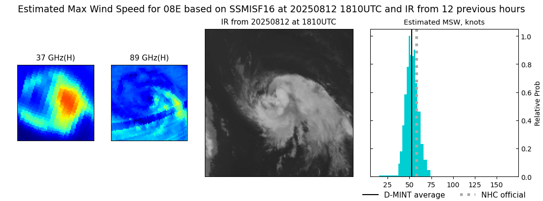 |
| 20250812 | 1743 UTC | GMI | 1002 hPa | 49 kts | 44 kts | 54 kts | 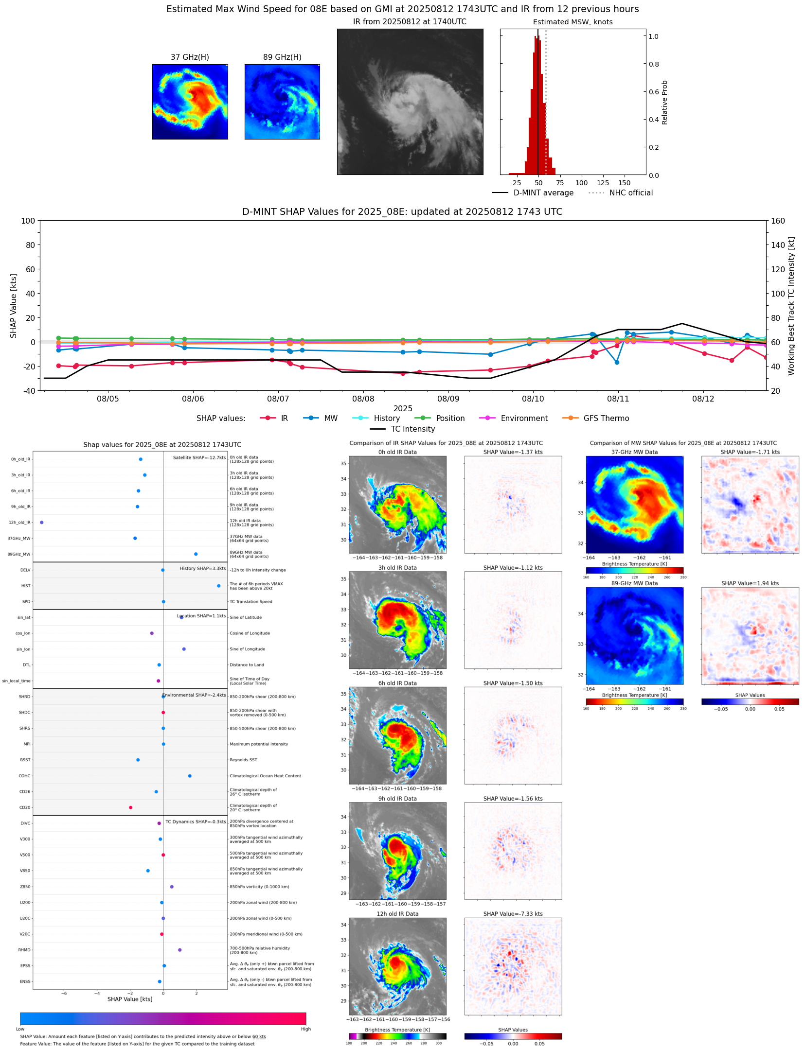 |
| 20250812 | 1222 UTC | AMSR2 | 1000 hPa | 64 kts | 58 kts | 69 kts |  |
| 20250812 | 1022 UTC | TMS03 | 1003 hPa | 51 kts | 45 kts | 56 kts | 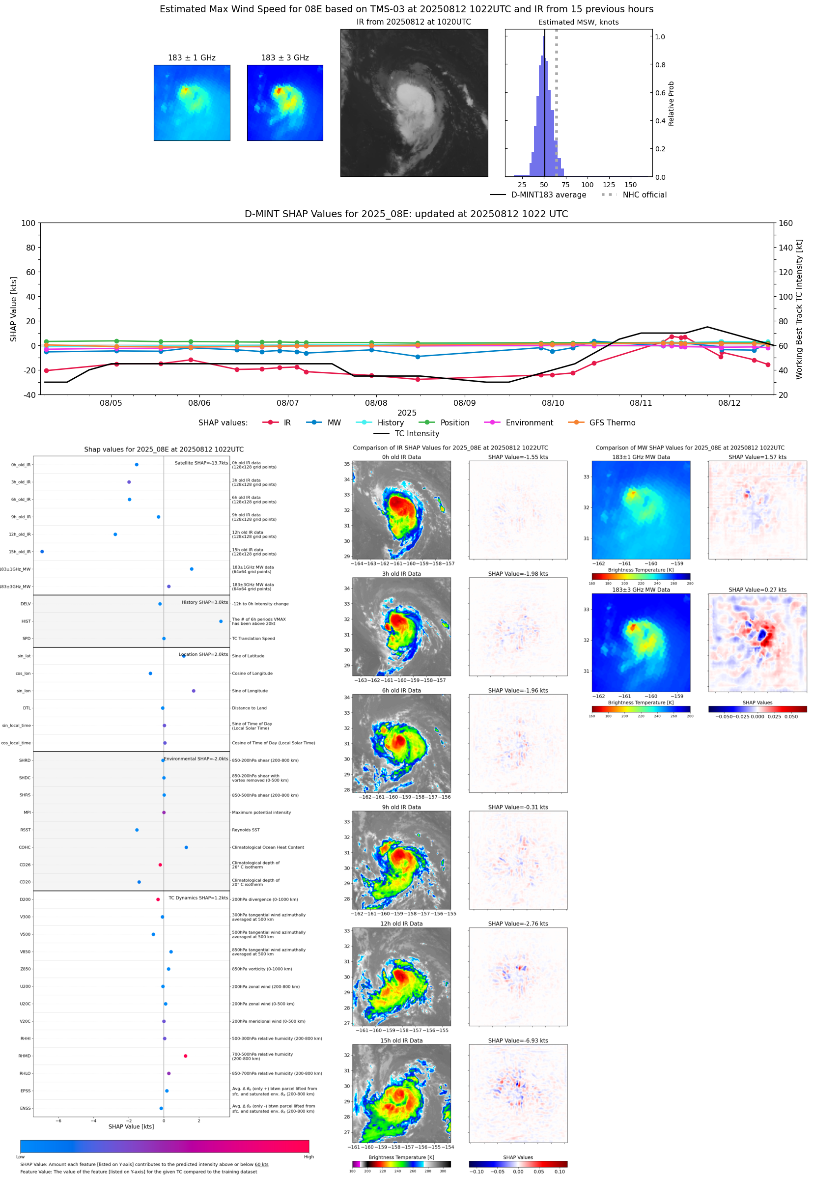 |
| 20250812 | 0820 UTC | TROPICS05 | 1003 hPa | 55 kts | 49 kts | 60 kts | 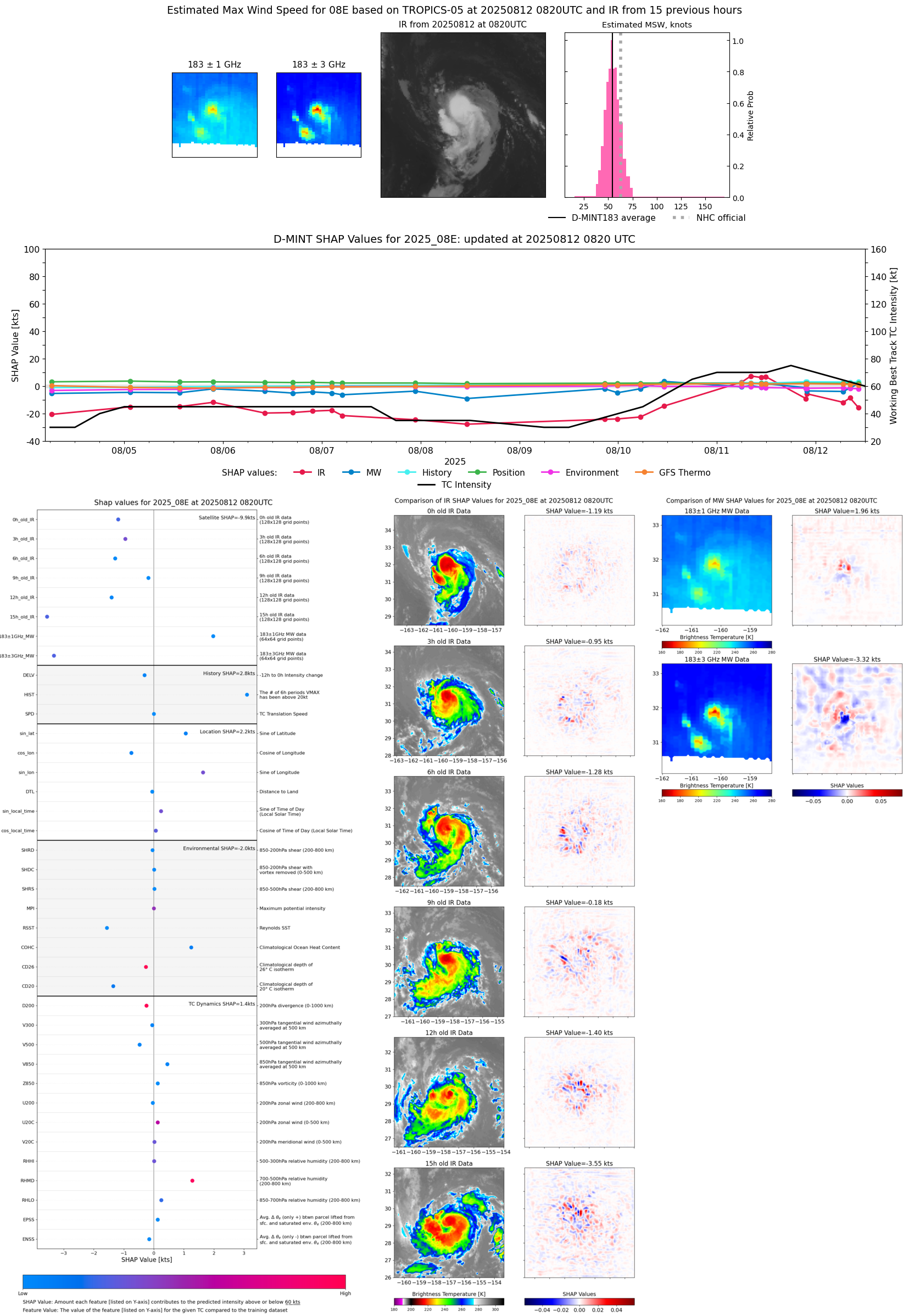 |
| 20250812 | 0802 UTC | GMI | 999 hPa | 47 kts | 43 kts | 53 kts | 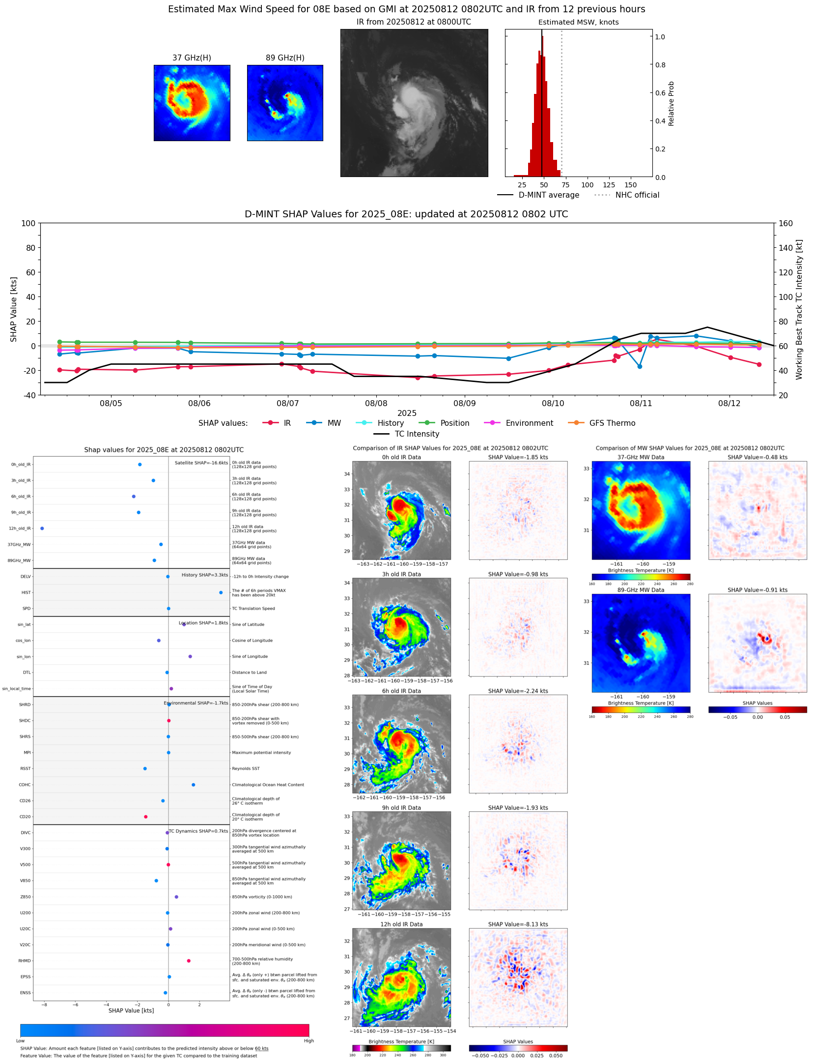 |
| 20250812 | 0758 UTC | GMI | 999 hPa | 49 kts | 44 kts | 54 kts | 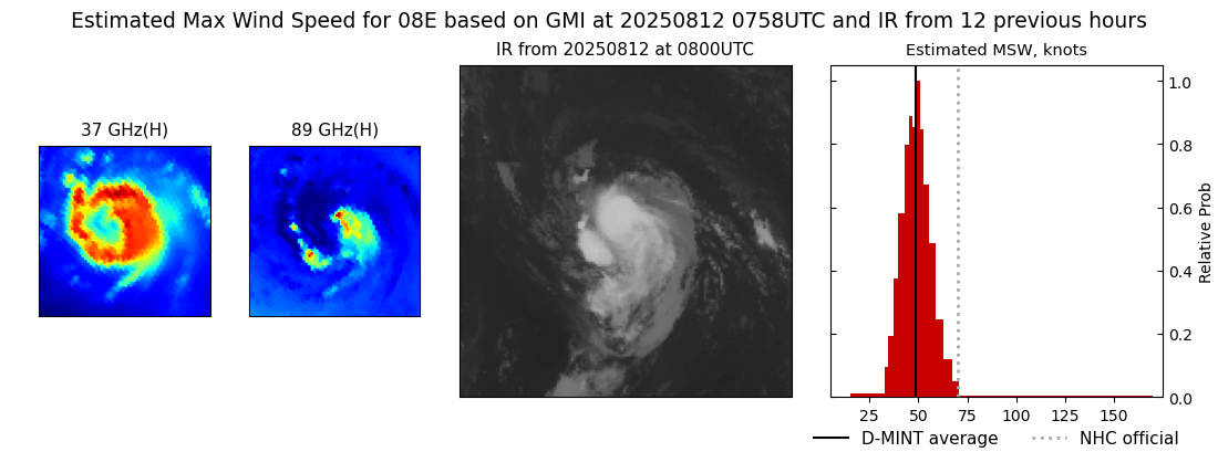 |
| 20250812 | 0642 UTC | TROPICS05 | 1003 hPa | 50 kts | 44 kts | 55 kts | 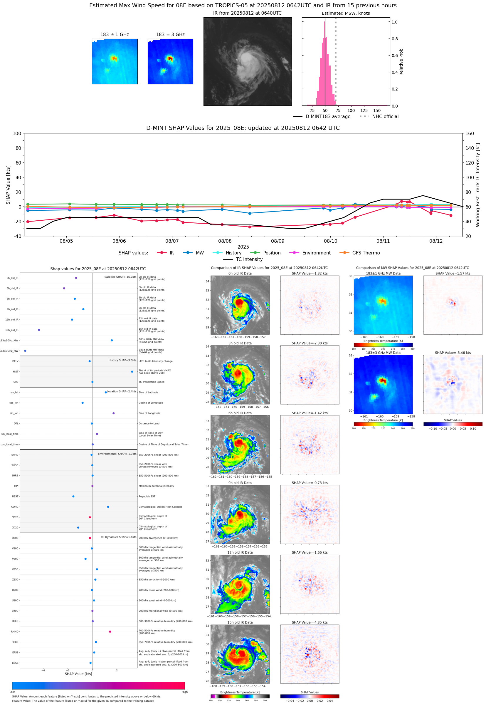 |
| 20250812 | 0018 UTC | AMSR2 | 997 hPa | 59 kts | 53 kts | 65 kts | 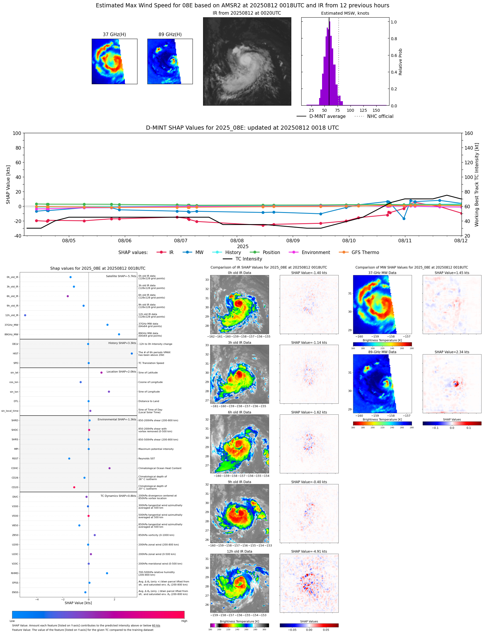 |
| 20250811 | 2309 UTC | ATMS-N21 | 997 hPa | 50 kts | 45 kts | 56 kts | 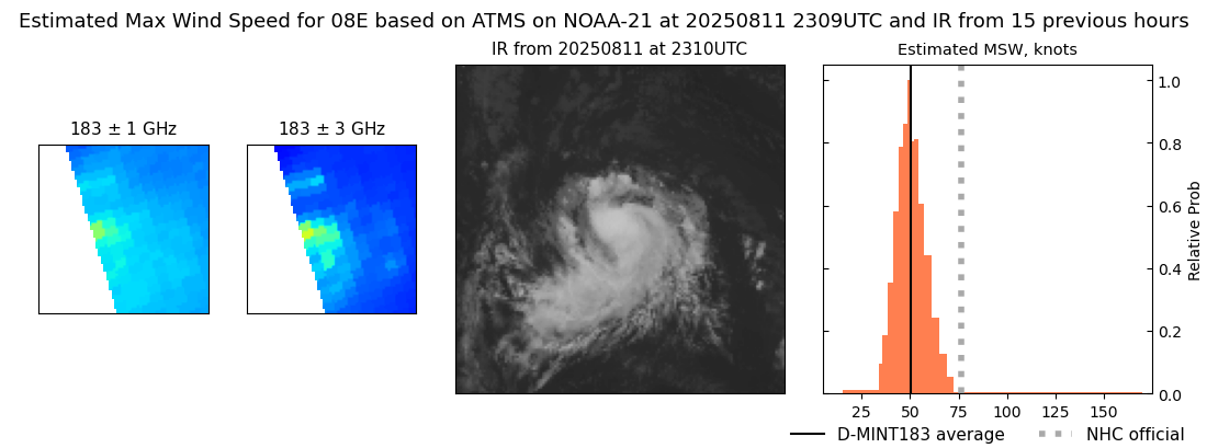 |
| 20250811 | 2155 UTC | TROPICS03 | 1001 hPa | 57 kts | 51 kts | 63 kts | 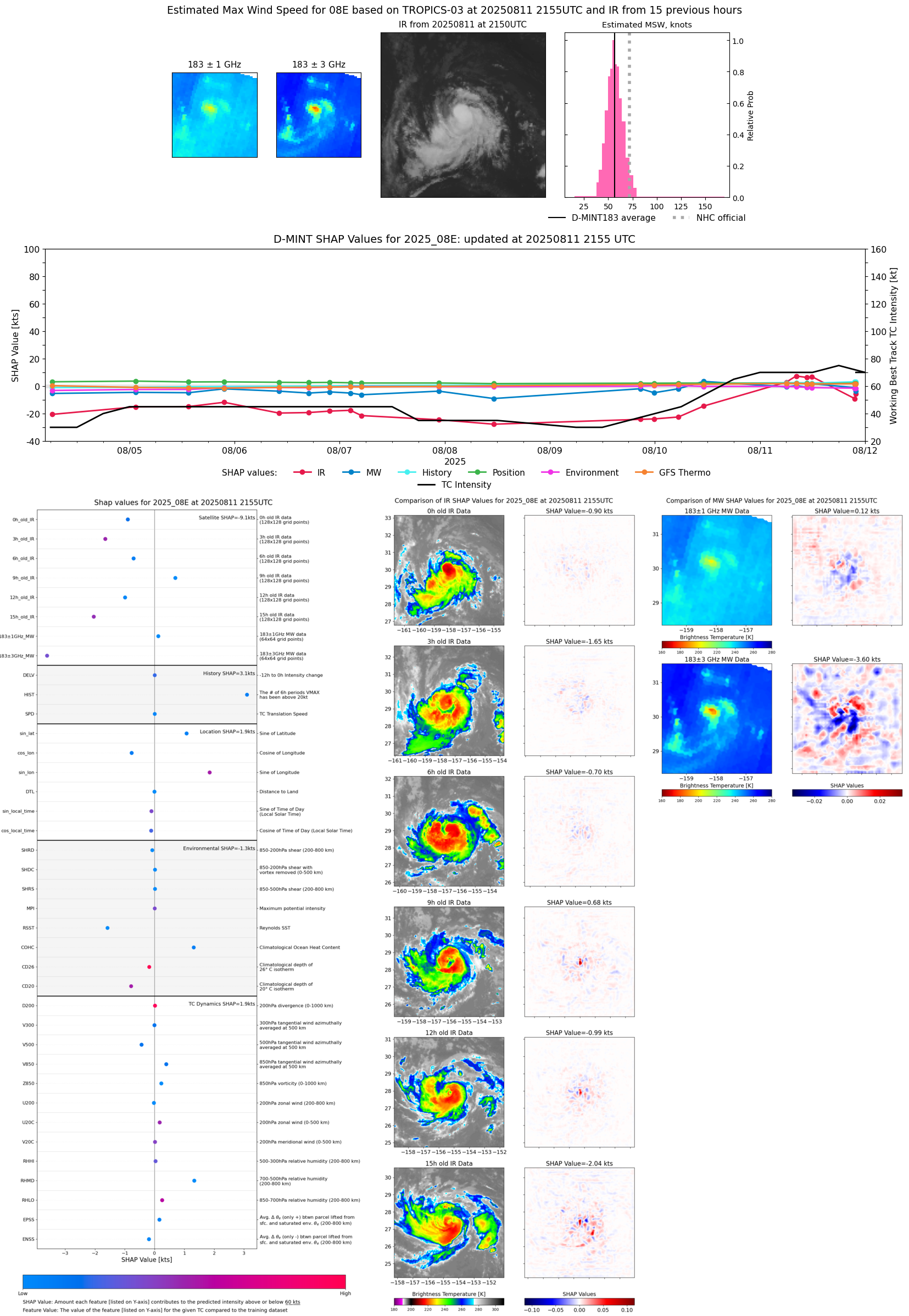 |
| 20250811 | 2137 UTC | TMS02 | 1000 hPa | 56 kts | 50 kts | 62 kts | 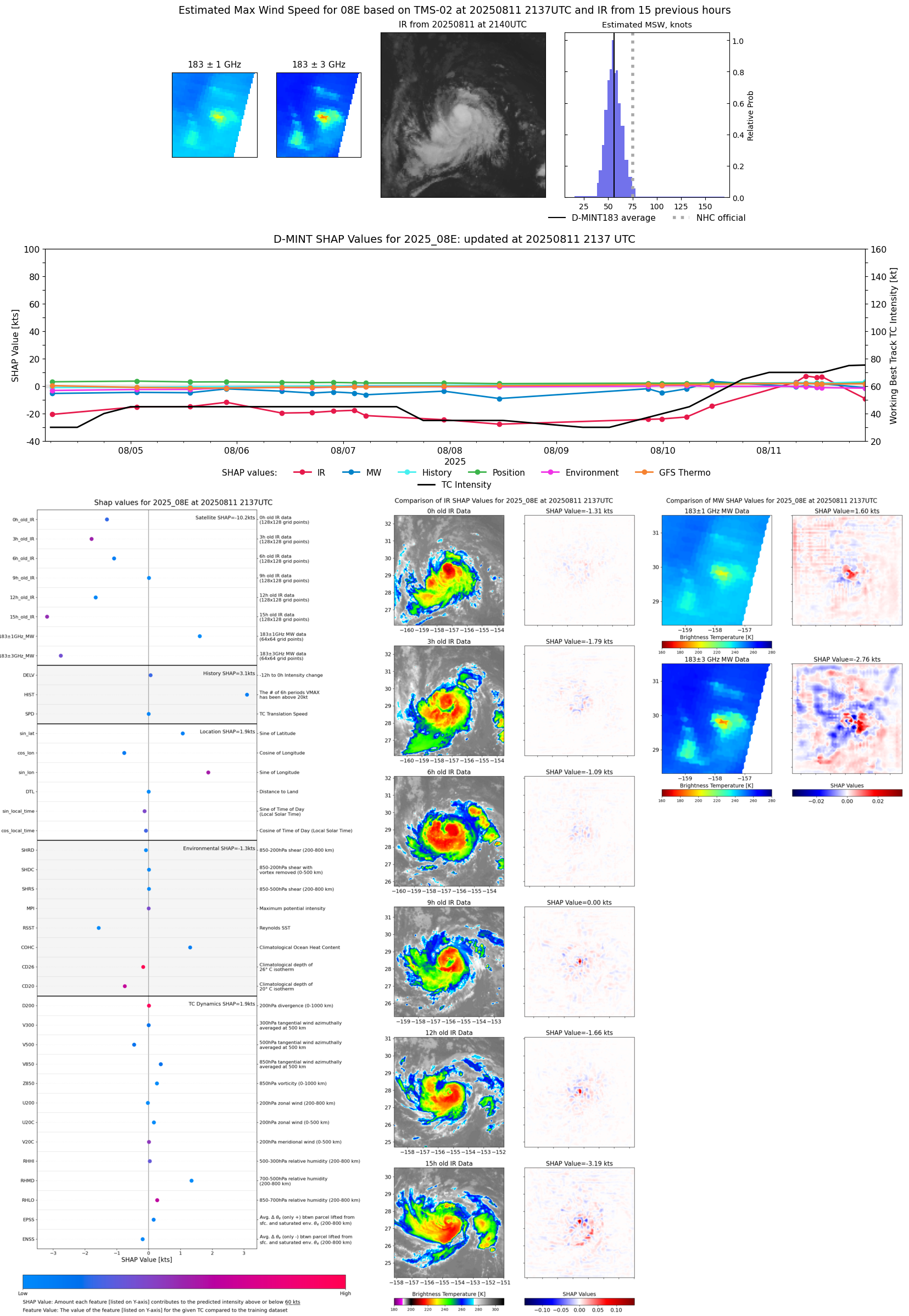 |
| 20250811 | 2119 UTC | AWS | 999 hPa | 57 kts | 52 kts | 63 kts | 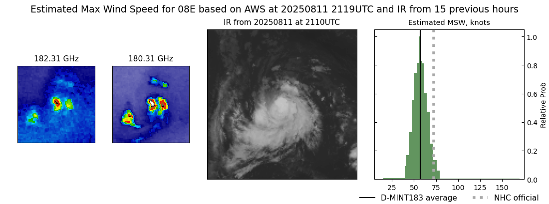 |
| 20250811 | 1455 UTC | SSMISF18 | 989 hPa | 72 kts | 67 kts | 78 kts | 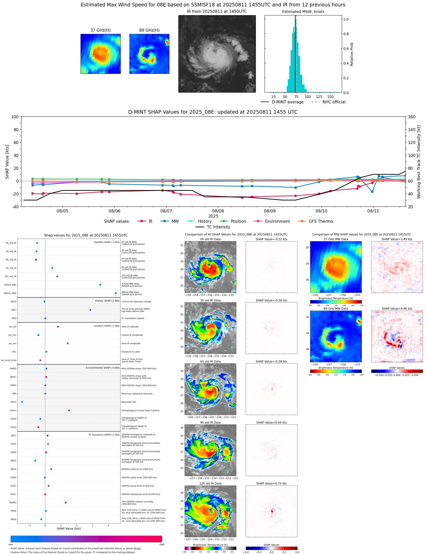 |
| 20250811 | 1153 UTC | ATMS-N21 | 992 hPa | 73 kts | 68 kts | 78 kts |  |
| 20250811 | 1045 UTC | TMS03 | 994 hPa | 71 kts | 65 kts | 76 kts |  |
| 20250811 | 0816 UTC | TMS02 | 990 hPa | 74 kts | 68 kts | 80 kts | 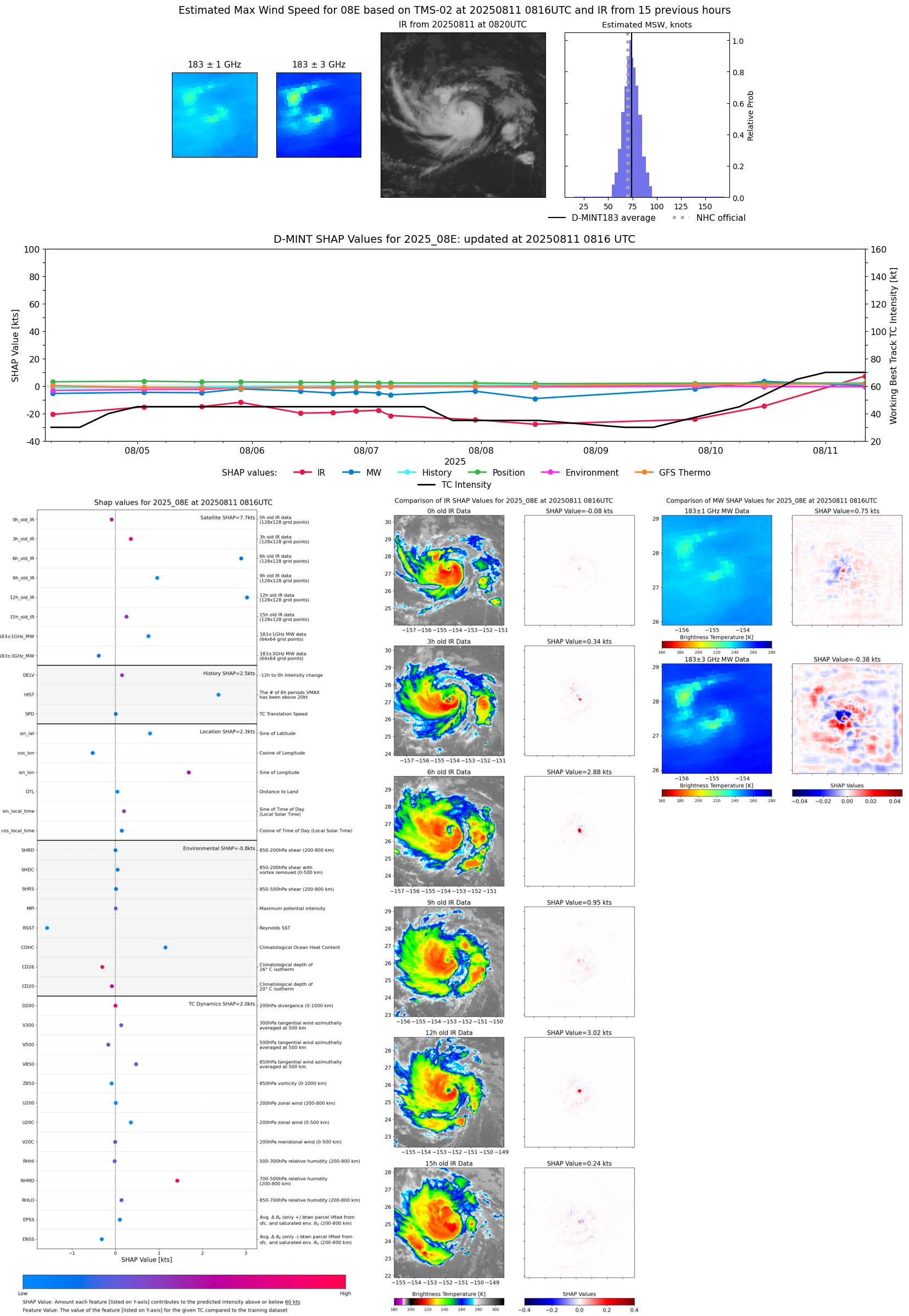 |
| 20250811 | 0602 UTC | TROPICS05 | 990 hPa | 69 kts | 64 kts | 74 kts | 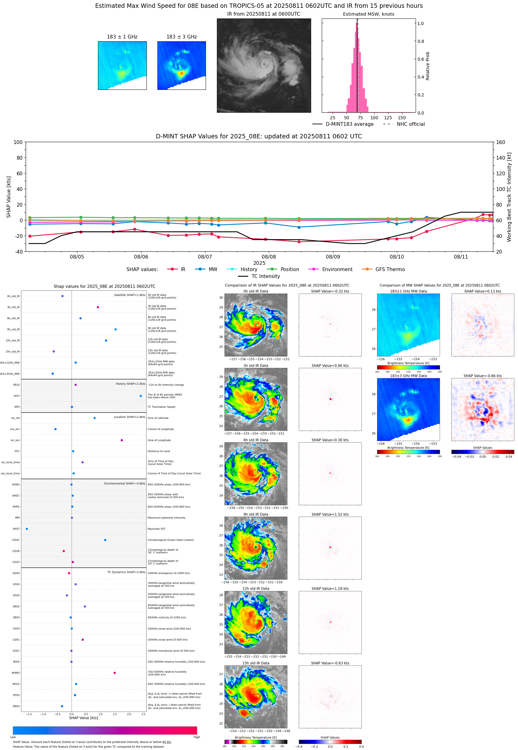 |
| 20250811 | 0416 UTC | SSMISF16 | 985 hPa | 78 kts | 71 kts | 84 kts | 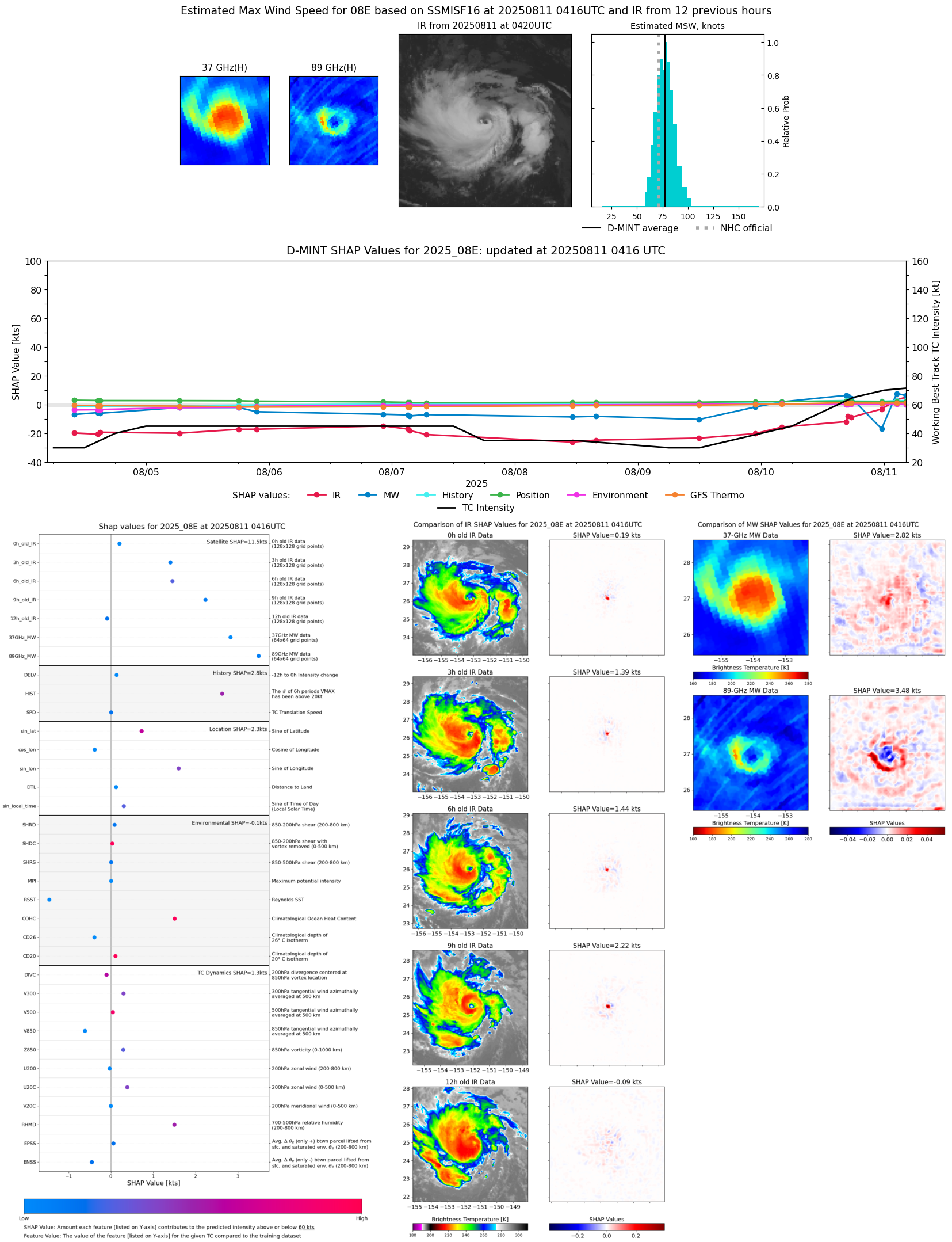 |
| 20250811 | 0351 UTC | SSMISF17 | 987 hPa | 76 kts | 70 kts | 83 kts | 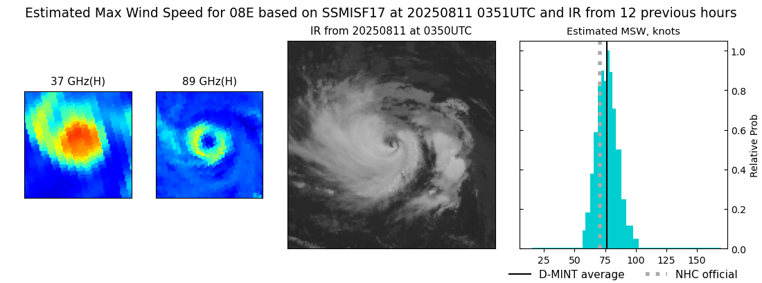 |
| 20250811 | 0228 UTC | SSMISF18 | 989 hPa | 77 kts | 71 kts | 83 kts | 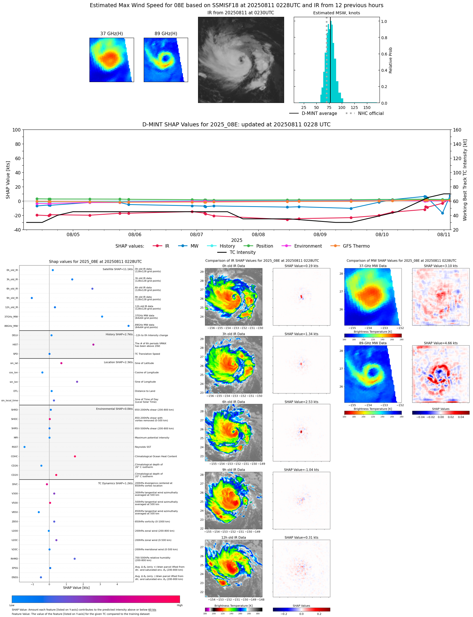 |
| 20250810 | 1738 UTC | GMI | 997 hPa | 62 kts | 57 kts | 67 kts | 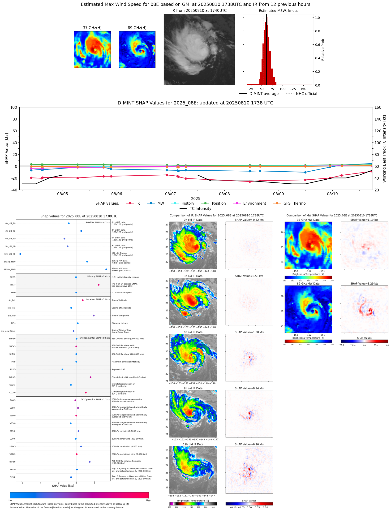 |
| 20250810 | 1658 UTC | SSMISF16 | 997 hPa | 65 kts | 59 kts | 70 kts | 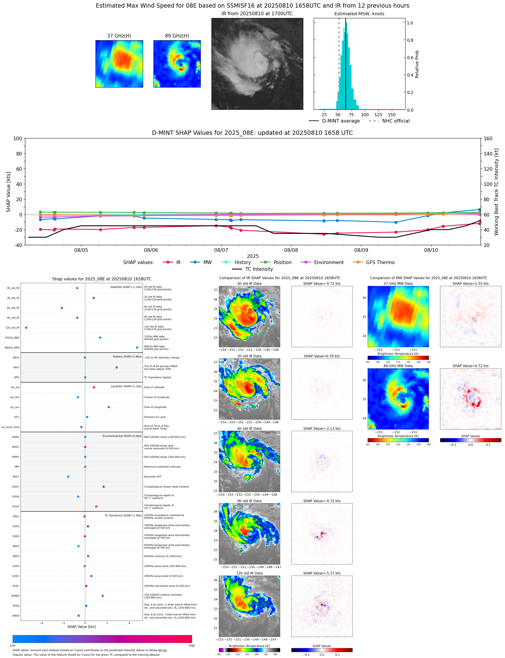 |
| 20250810 | 1634 UTC | SSMISF17 | 997 hPa | 61 kts | 56 kts | 67 kts | 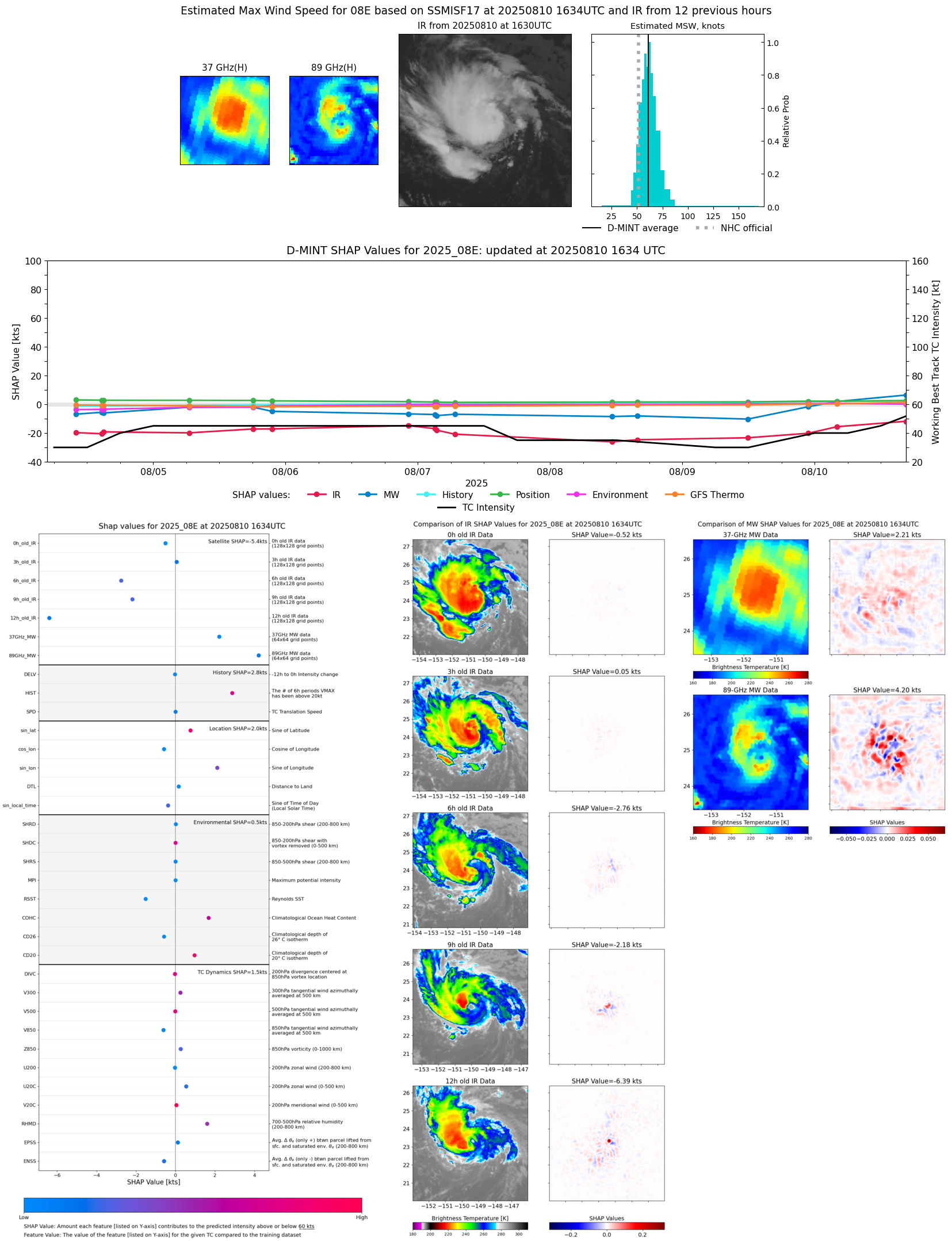 |
| 20250810 | 1107 UTC | TMS03 | 995 hPa | 54 kts | 50 kts | 59 kts | 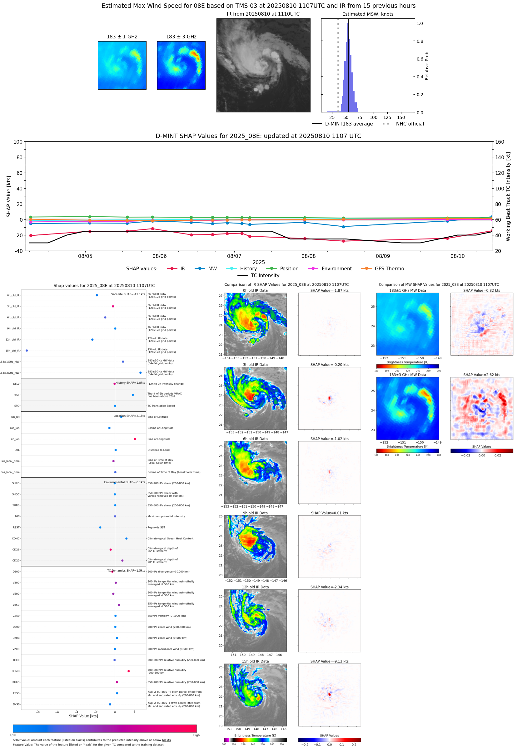 |
| 20250810 | 0522 UTC | TROPICS05 | 1003 hPa | 42 kts | 38 kts | 46 kts | 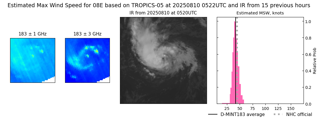 |
| 20250810 | 0428 UTC | SSMISF16 | 1001 hPa | 48 kts | 44 kts | 53 kts | 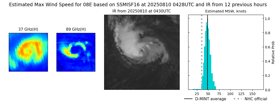 |
| 20250810 | 0404 UTC | SSMISF17 | 1002 hPa | 51 kts | 47 kts | 56 kts |  |
| 20250809 | 2351 UTC | TROPICS03 | 1005 hPa | 37 kts | 34 kts | 40 kts |  |
| 20250809 | 2249 UTC | AMSR2 | 1004 hPa | 43 kts | 39 kts | 47 kts |  |
| 20250809 | 2042 UTC | TMS02 | 1005 hPa | 39 kts | 36 kts | 43 kts | 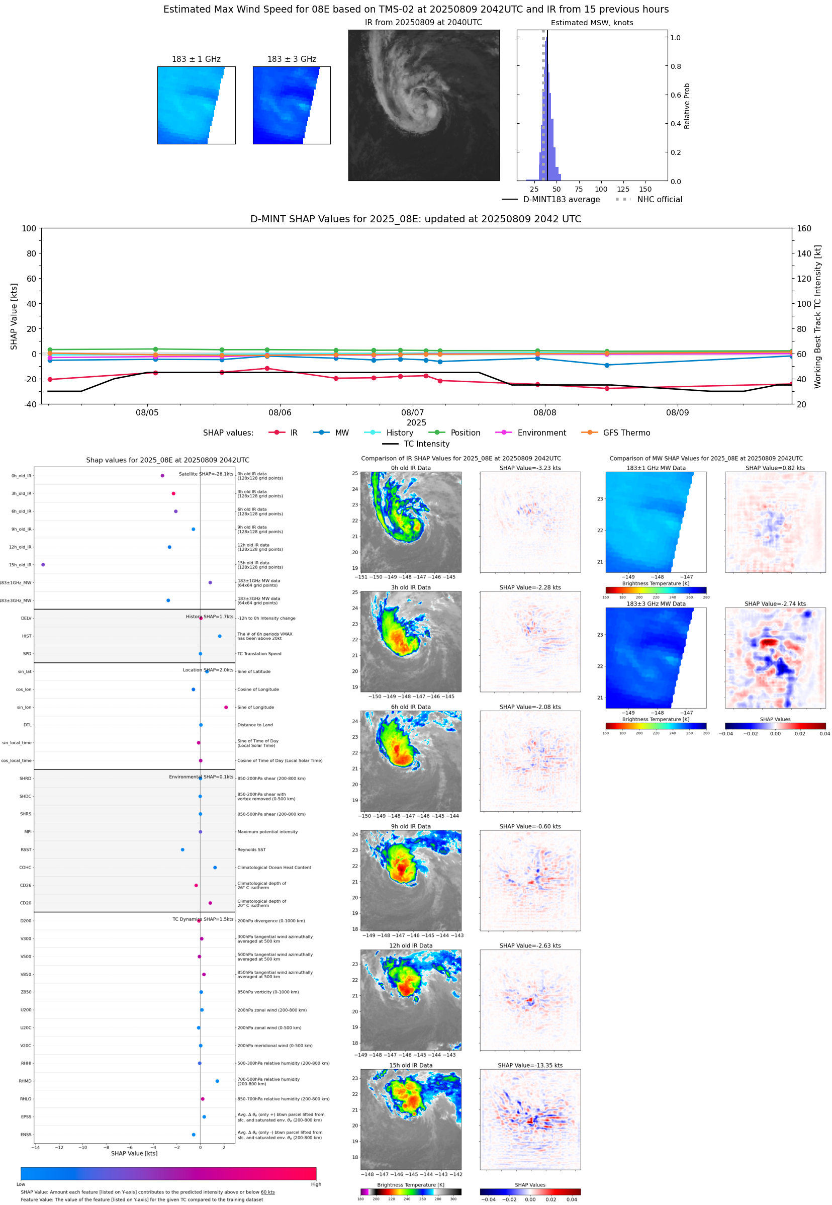 |
| 20250809 | 1154 UTC | AMSR2 | 1010 hPa | 29 kts | 27 kts | 32 kts | 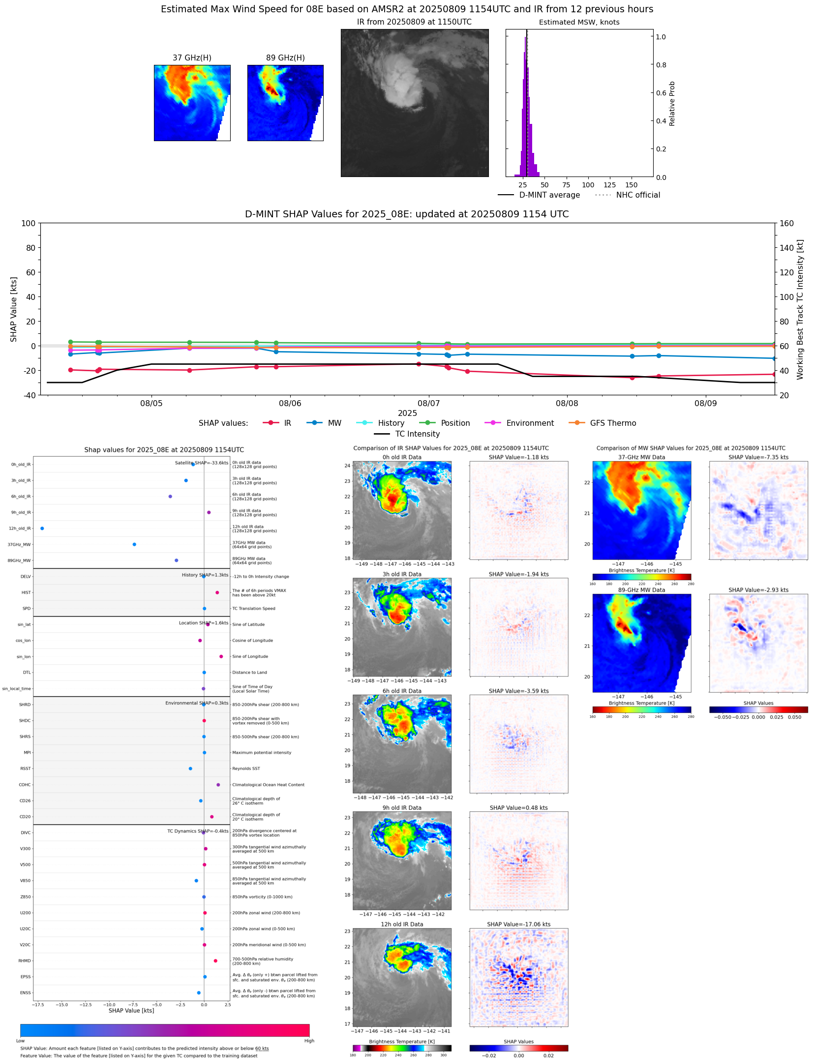 |
| 20250809 | 0111 UTC | SSMISF18 | 1011 hPa | 28 kts | 26 kts | 31 kts |  |
| 20250808 | 1547 UTC | SSMISF16 | 1011 hPa | 29 kts | 27 kts | 32 kts | 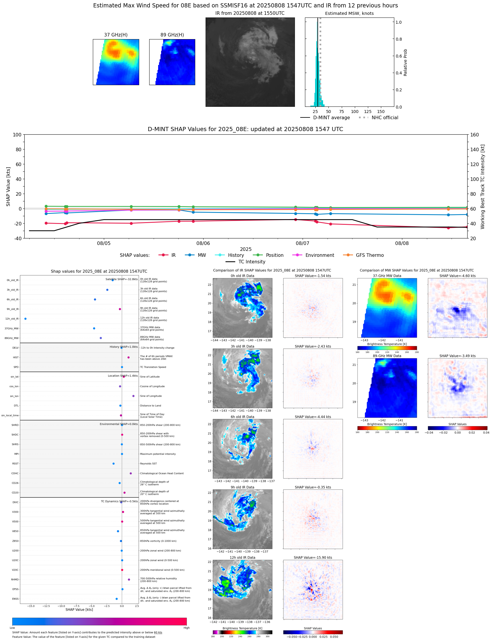 |
| 20250808 | 1358 UTC | SSMISF18 | 1010 hPa | 31 kts | 28 kts | 34 kts | 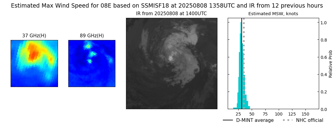 |
| 20250808 | 1111 UTC | AMSR2 | 1012 hPa | 27 kts | 25 kts | 29 kts | 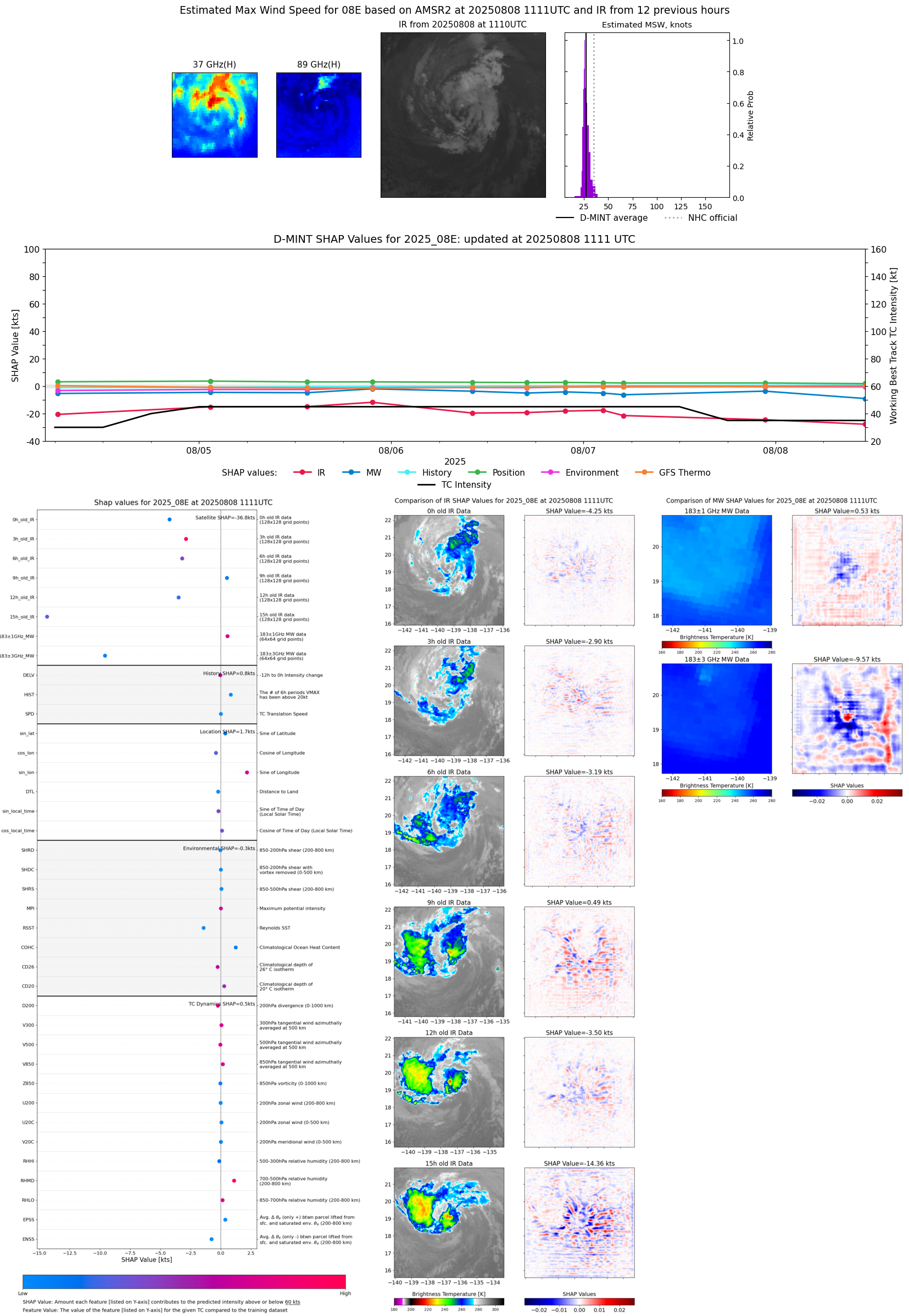 |
| 20250808 | 1111 UTC | ATMS-N21 | 1014 hPa | 26 kts | 24 kts | 28 kts |  |
| 20250807 | 2240 UTC | ATMS-N21 | 1012 hPa | 35 kts | 32 kts | 38 kts | 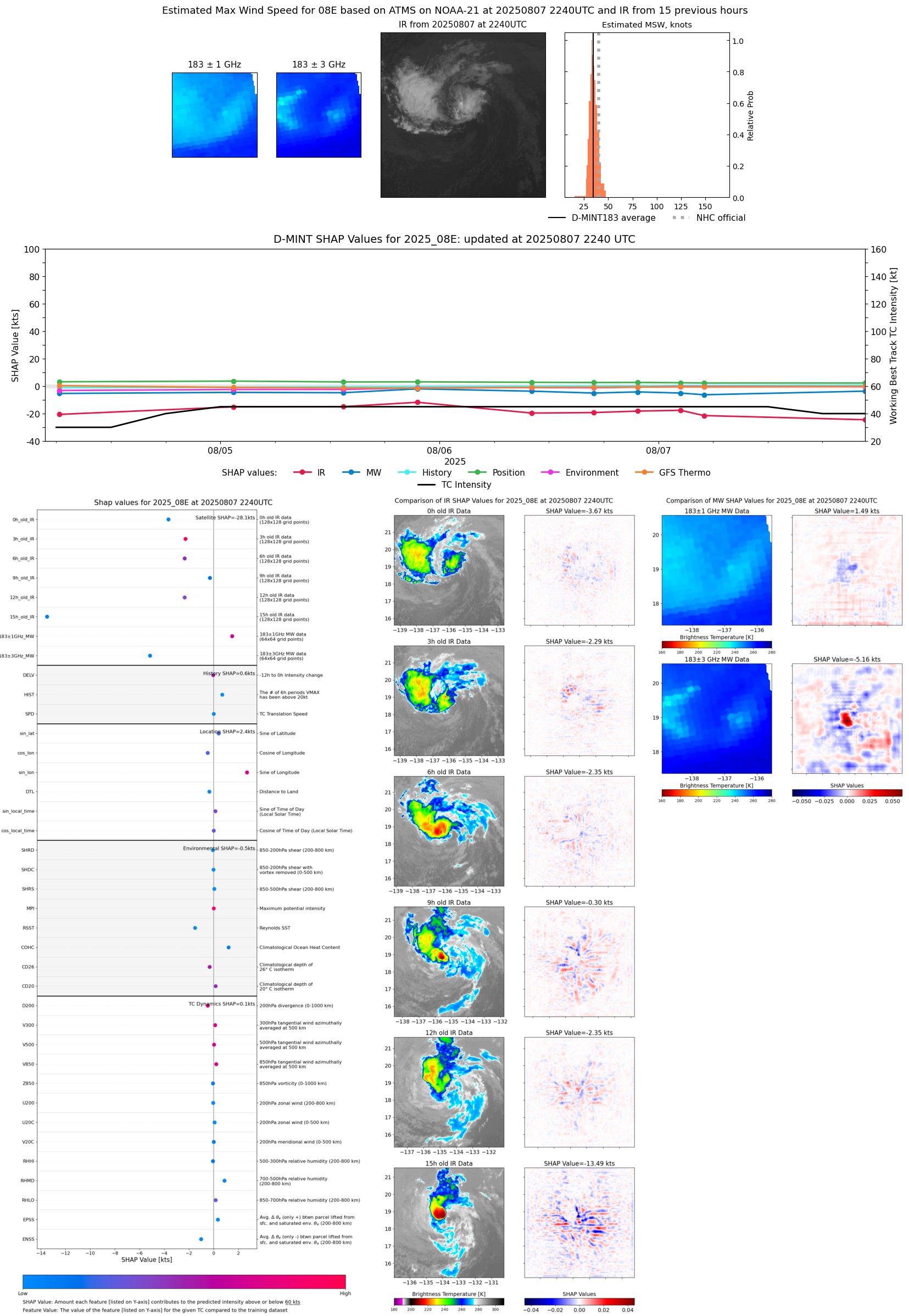 |
| 20250807 | 1537 UTC | SSMISF17 | 1010 hPa | 33 kts | 30 kts | 36 kts |  |
| 20250807 | 1028 UTC | AMSR2 | 1012 hPa | 31 kts | 29 kts | 35 kts | 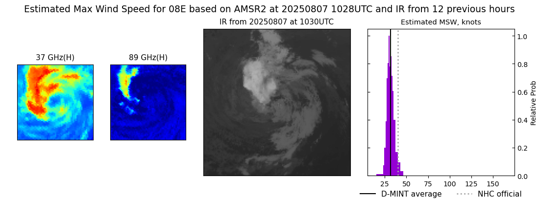 |
| 20250807 | 0707 UTC | AWS | 1011 hPa | 35 kts | 32 kts | 38 kts | 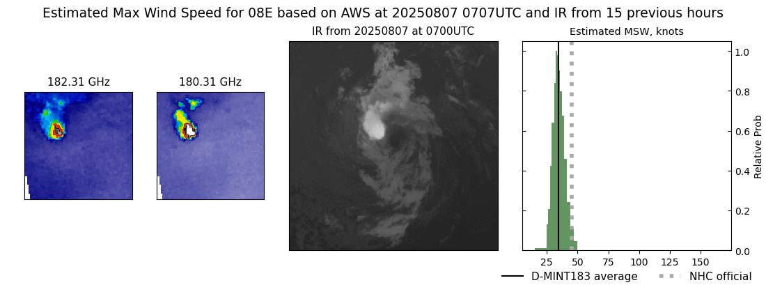 |
| 20250807 | 0643 UTC | GMI | 1011 hPa | 32 kts | 30 kts | 36 kts | 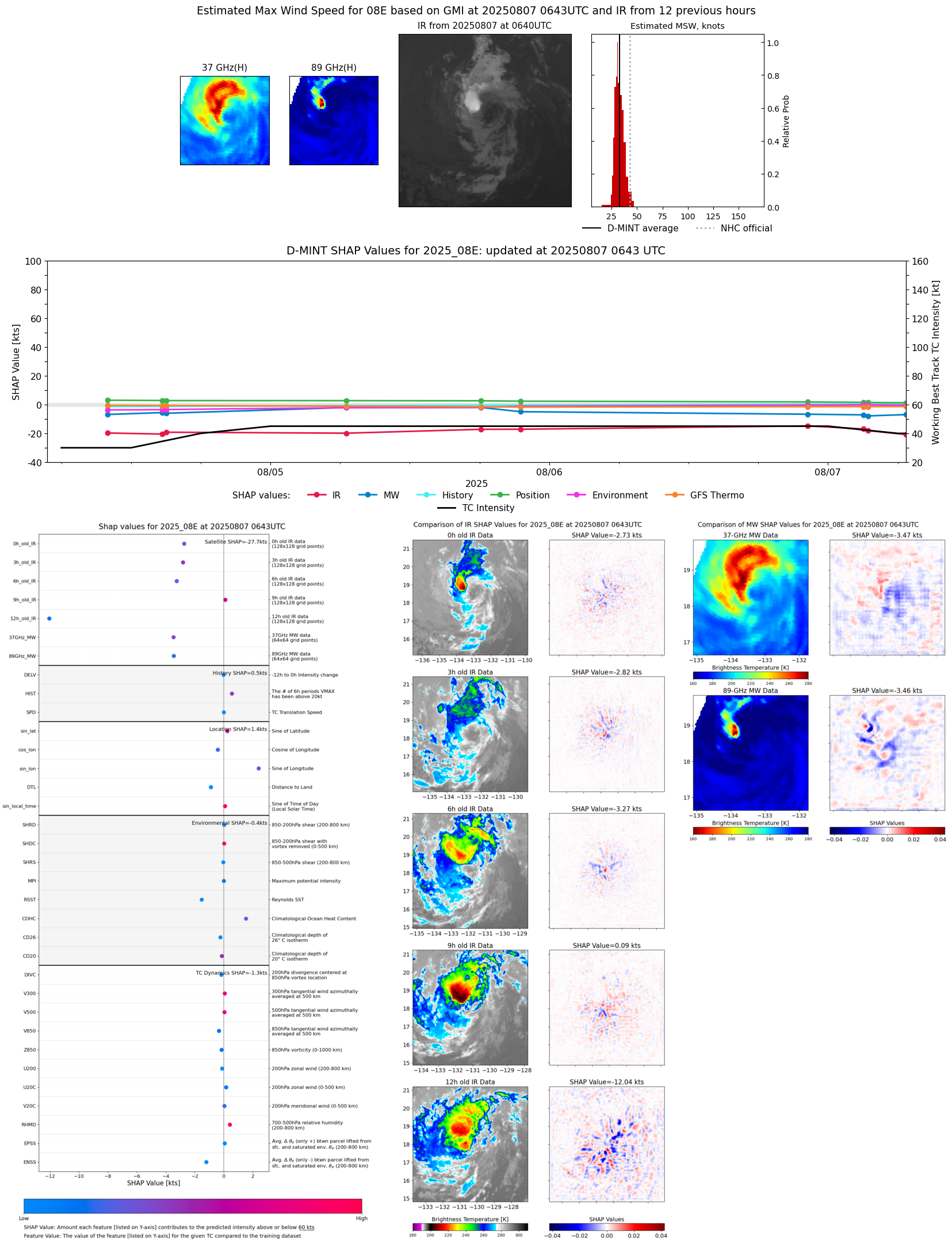 |
| 20250807 | 0500 UTC | TROPICS05 | 1010 hPa | 34 kts | 32 kts | 38 kts | 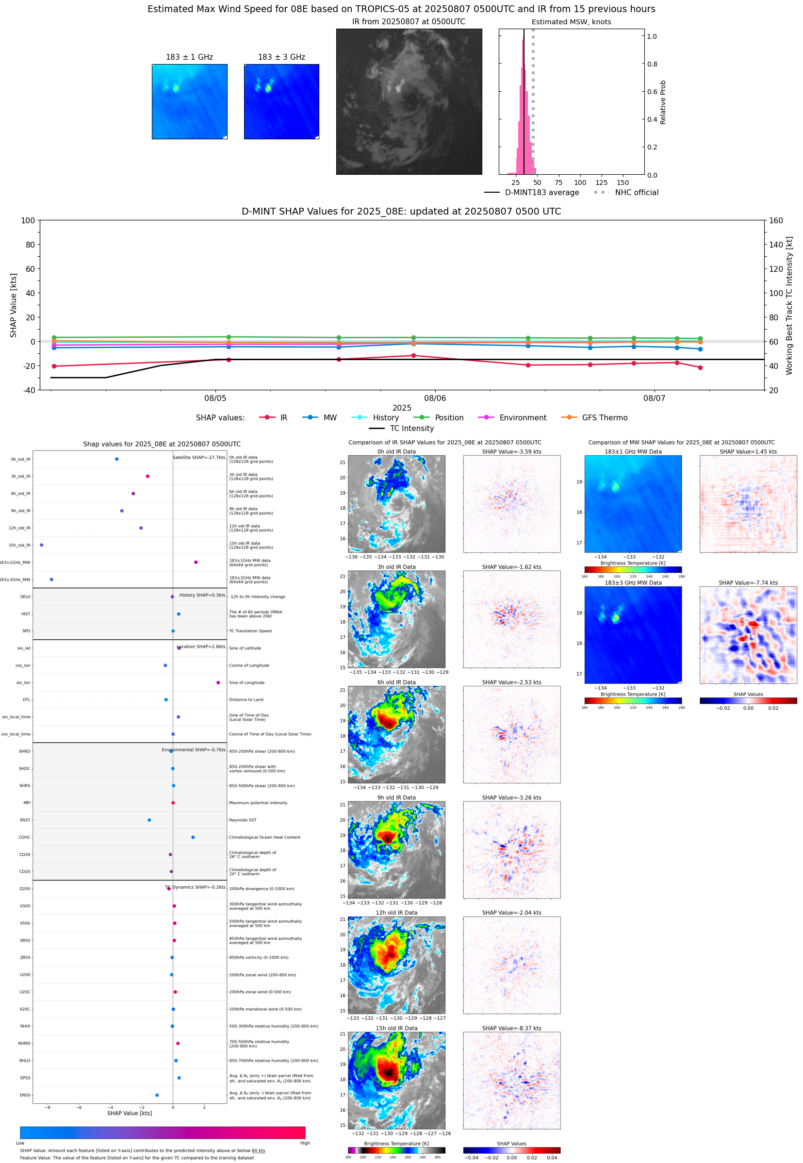 |
| 20250807 | 0326 UTC | SSMISF16 | 1008 hPa | 34 kts | 31 kts | 38 kts |  |
| 20250807 | 0304 UTC | SSMISF17 | 1008 hPa | 36 kts | 33 kts | 40 kts | 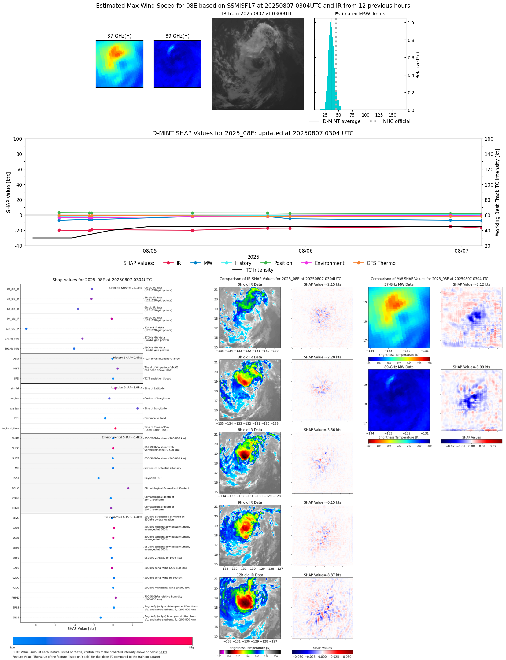 |
| 20250807 | 0227 UTC | TMS03 | 1008 hPa | 40 kts | 37 kts | 43 kts |  |
| 20250806 | 2216 UTC | AMSR2 | 1009 hPa | 39 kts | 35 kts | 43 kts |  |
| 20250806 | 2145 UTC | ATMS-NPP | 1004 hPa | 40 kts | 36 kts | 43 kts | 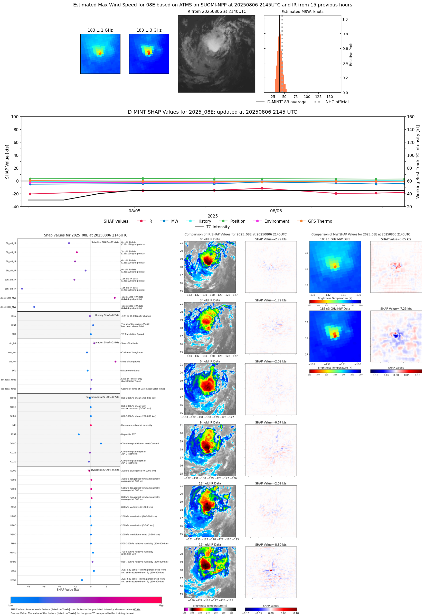 |
| 20250806 | 1656 UTC | TROPICS03 | 1007 hPa | 37 kts | 34 kts | 41 kts | 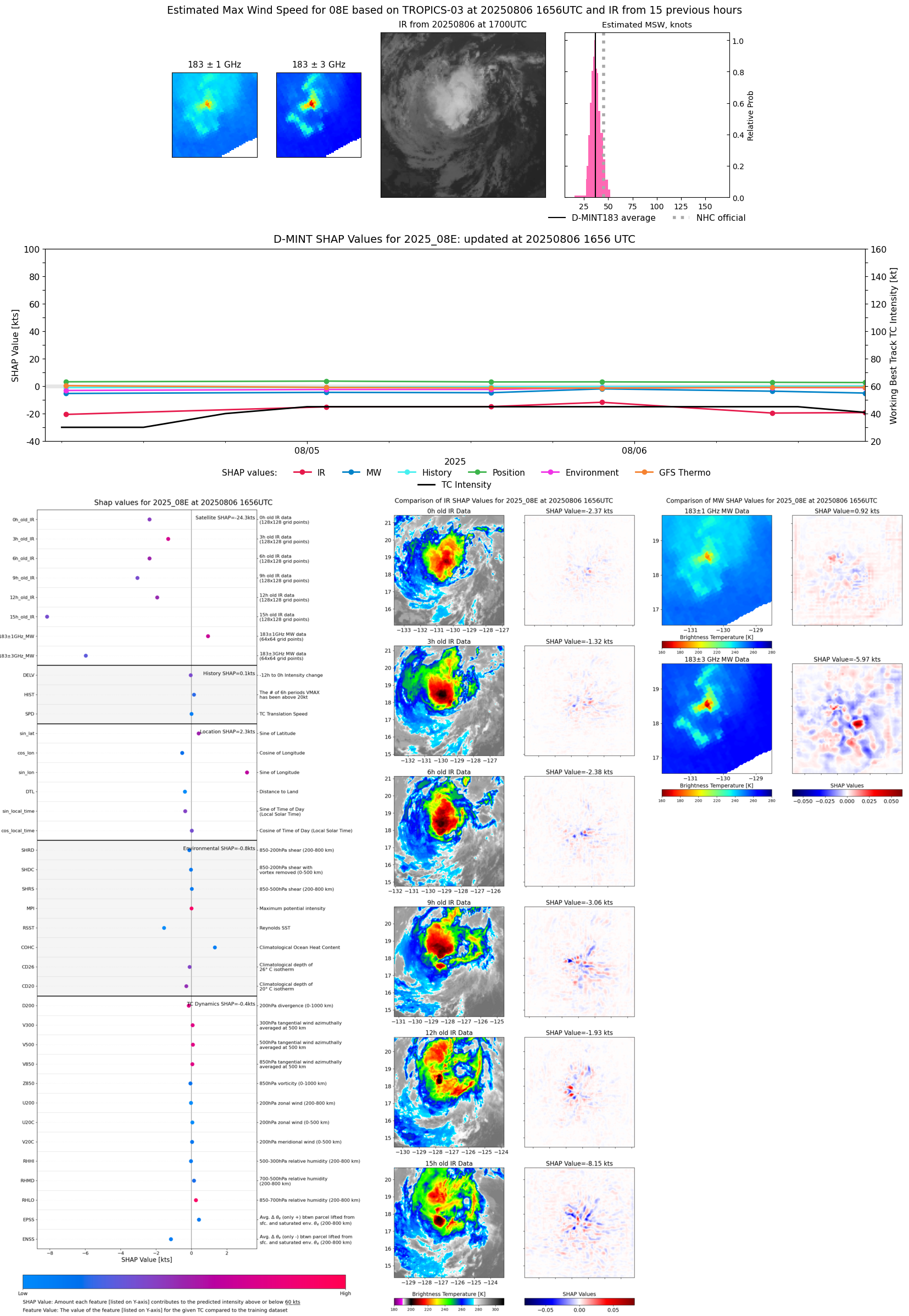 |
| 20250806 | 1008 UTC | ATMS-N21 | 1008 hPa | 38 kts | 34 kts | 42 kts | 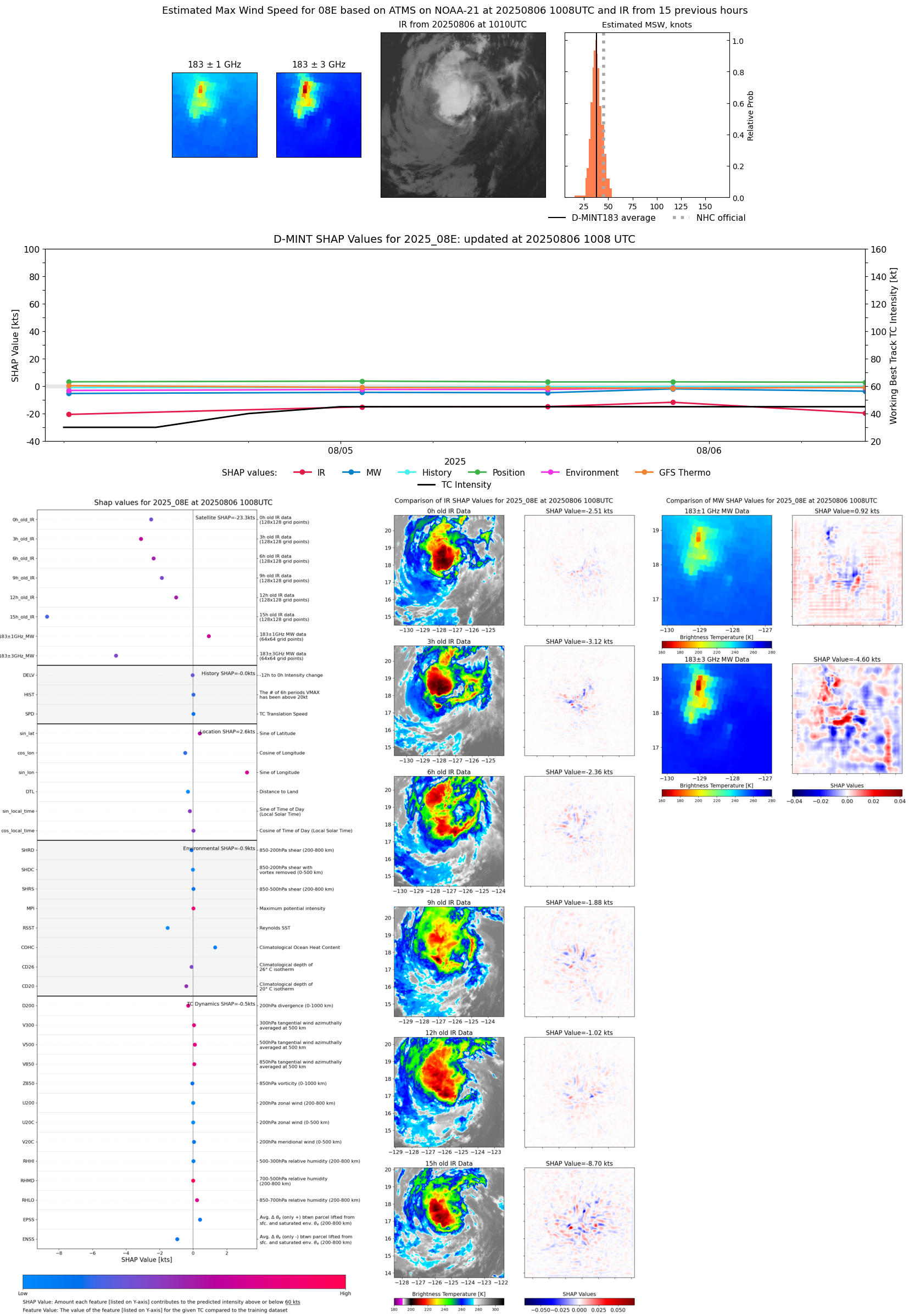 |
| 20250806 | 0656 UTC | AWS | 1007 hPa | 37 kts | 33 kts | 41 kts |  |
| 20250805 | 2137 UTC | ATMS-N21 | 1005 hPa | 47 kts | 43 kts | 52 kts | 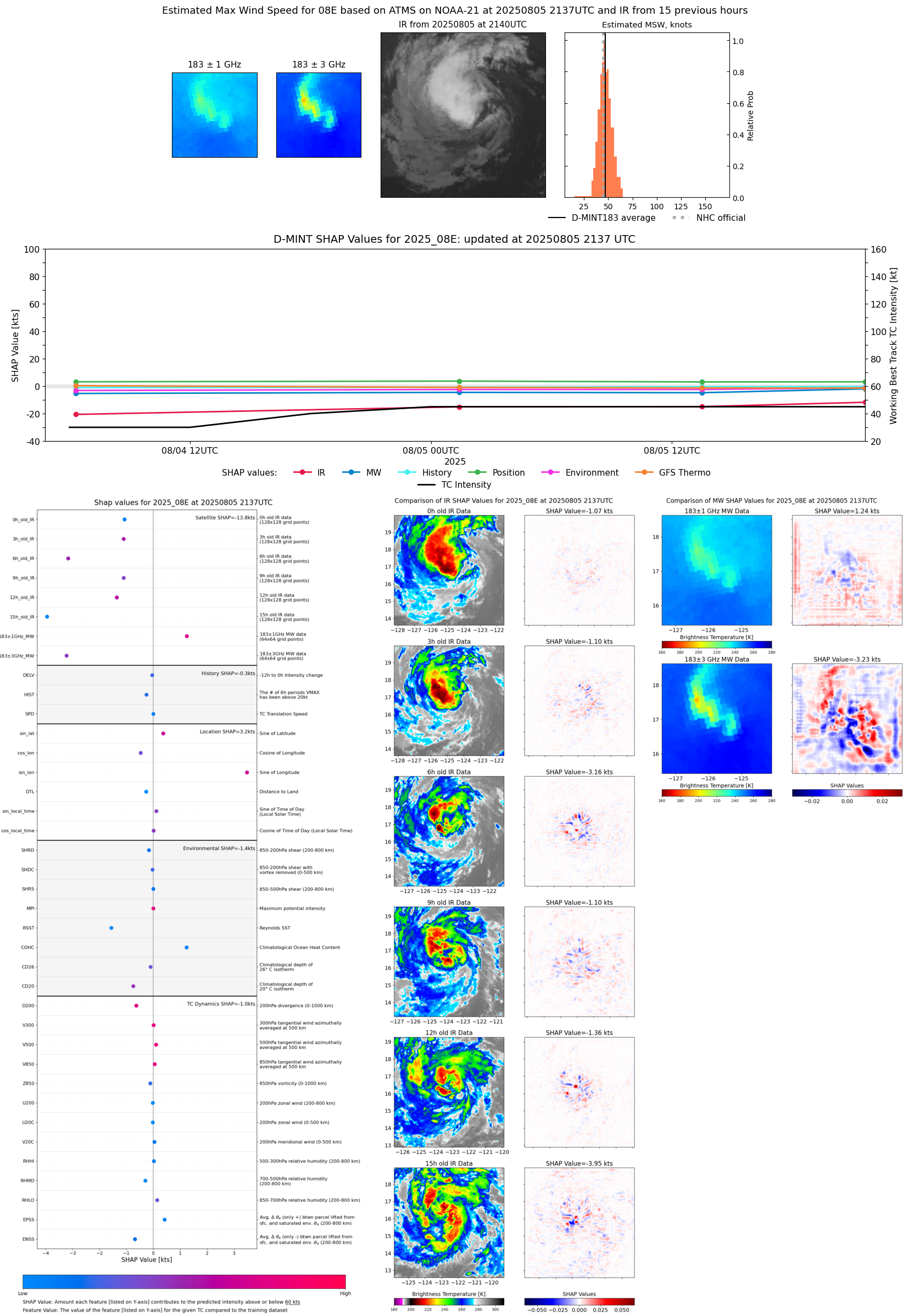 |
| 20250805 | 2133 UTC | AMSR2 | 1009 hPa | 37 kts | 34 kts | 41 kts | 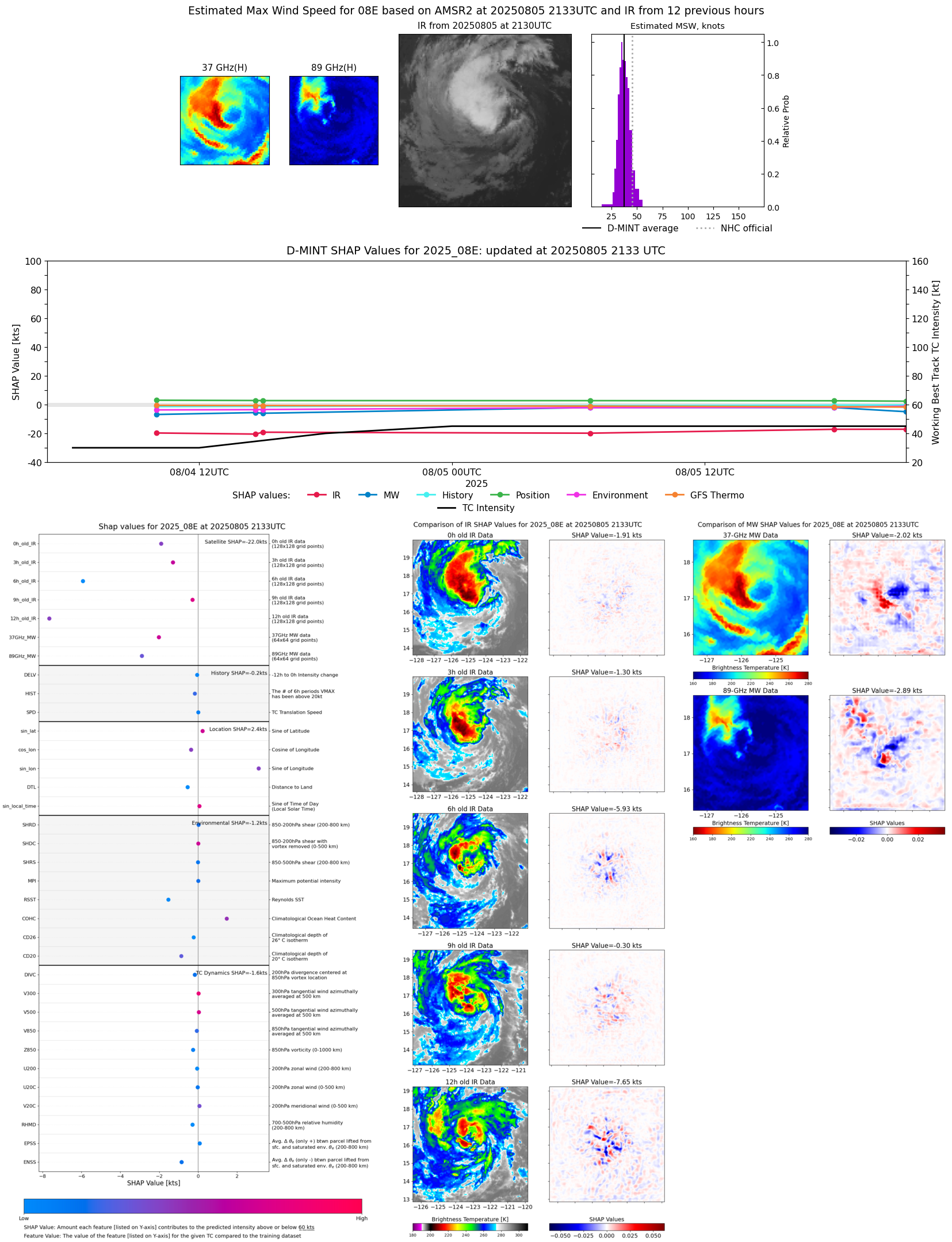 |
| 20250805 | 1808 UTC | GMI | 1009 hPa | 40 kts | 36 kts | 44 kts | 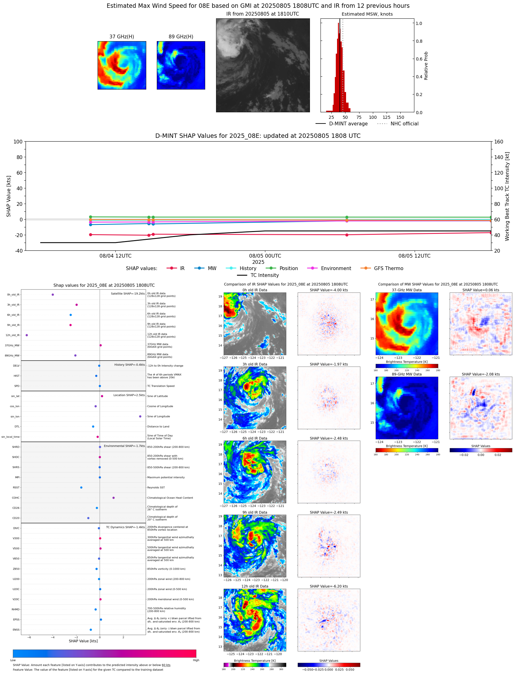 |
| 20250805 | 1329 UTC | TROPICS05 | 1006 hPa | 40 kts | 36 kts | 44 kts | 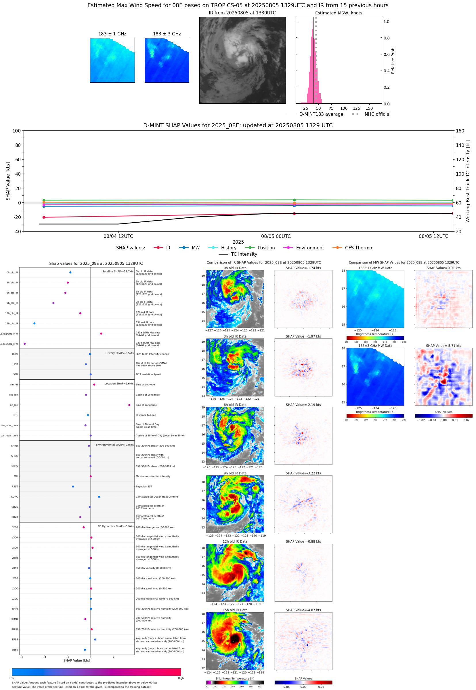 |
| 20250805 | 0633 UTC | GMI | 1004 hPa | 37 kts | 33 kts | 41 kts | 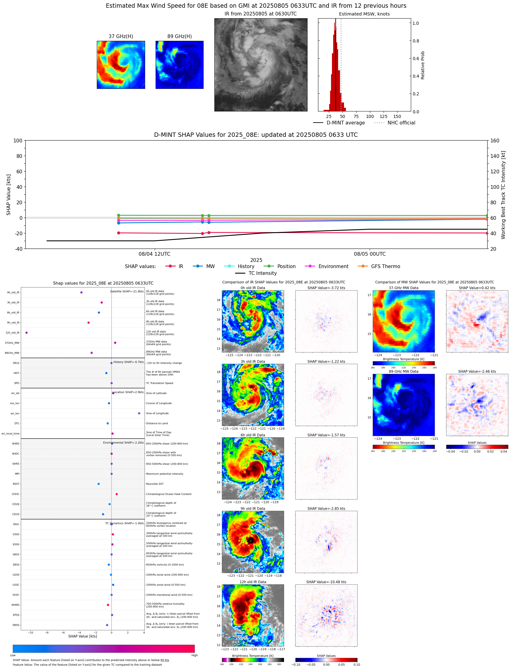 |
| 20250805 | 0150 UTC | SSMISF17 | 1005 hPa | 42 kts | 38 kts | 47 kts | 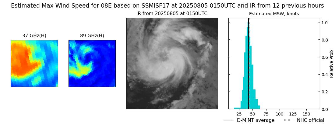 |
| 20250805 | 0124 UTC | TROPICS03 | 1006 hPa | 41 kts | 36 kts | 46 kts | 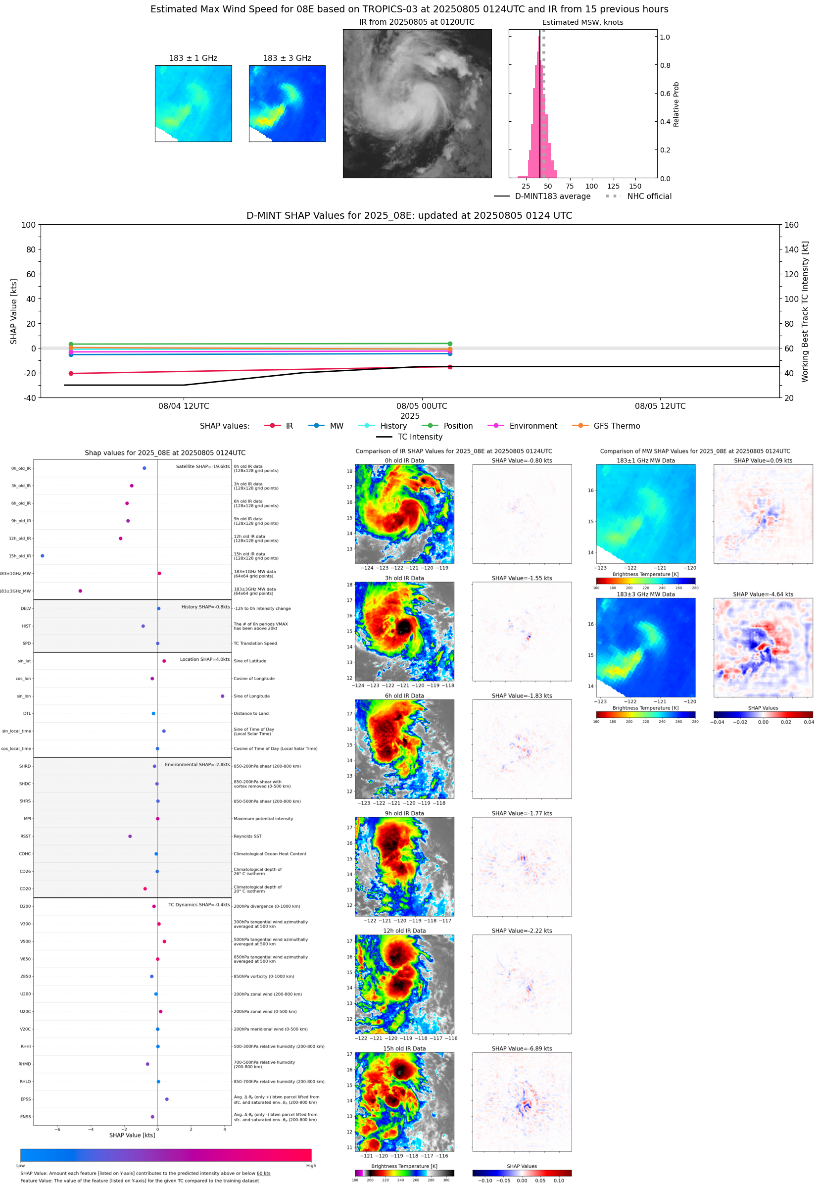 |
| 20250804 | 1831 UTC | AWS | 1004 hPa | 29 kts | 27 kts | 33 kts | 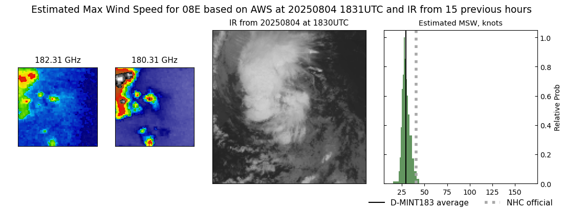 |
| 20250804 | 1501 UTC | SSMISF16 | 1006 hPa | 32 kts | 29 kts | 36 kts | 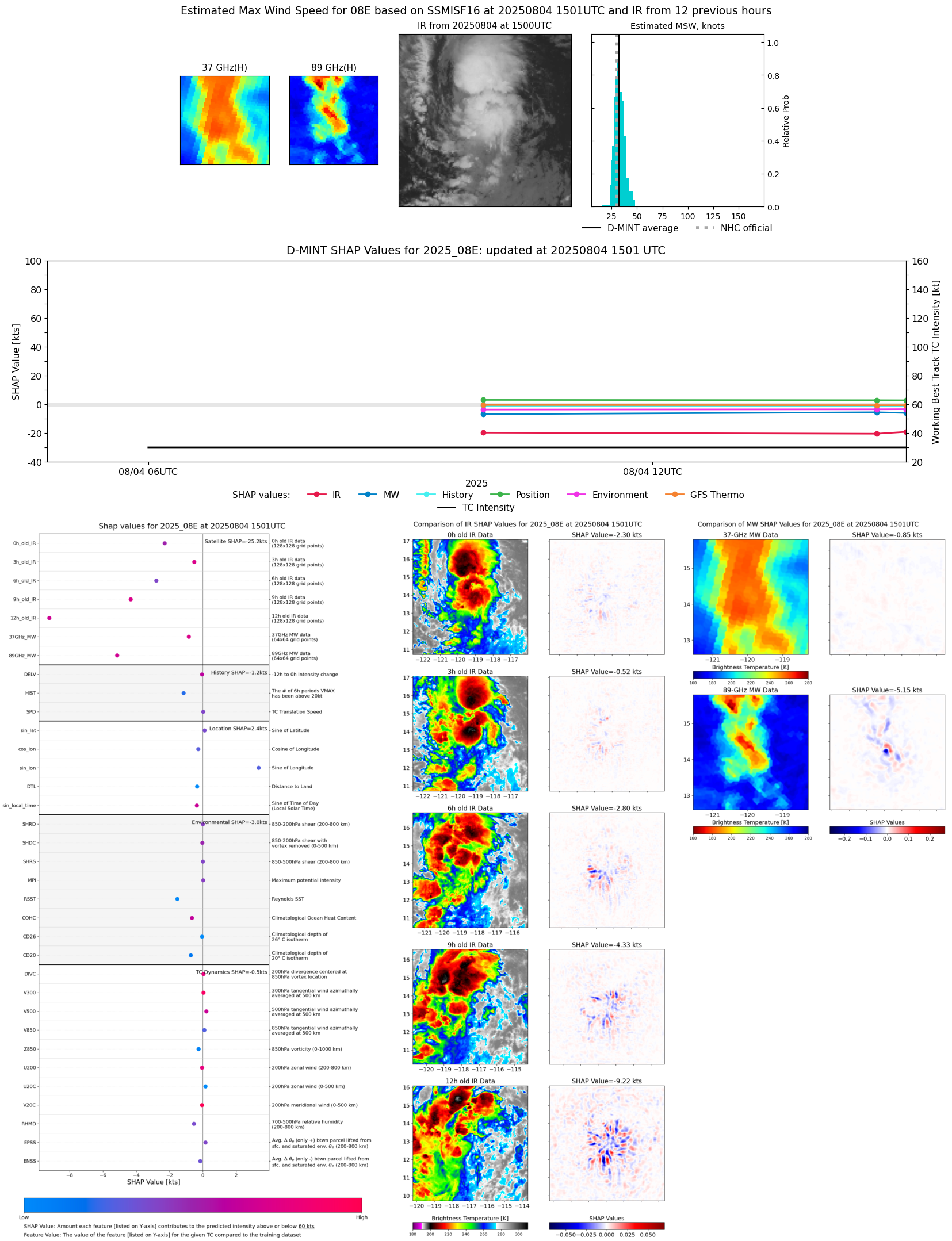 |
| 20250804 | 1440 UTC | SSMISF17 | 1006 hPa | 32 kts | 28 kts | 35 kts | 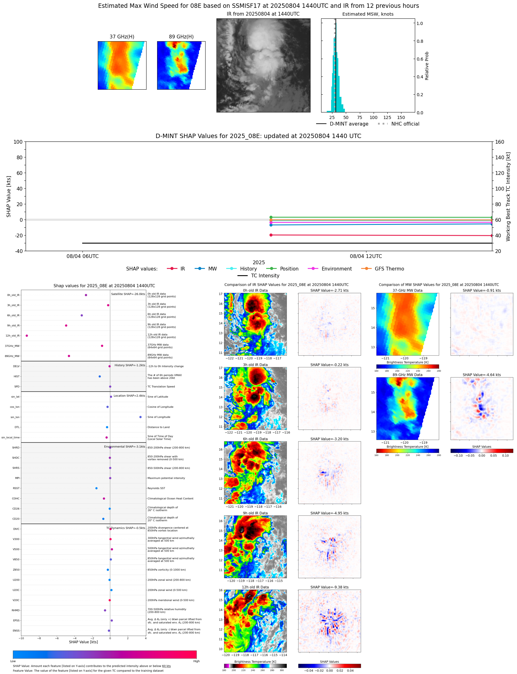 |
| 20250804 | 0959 UTC | AMSR2 | 1007 hPa | 31 kts | 28 kts | 33 kts | 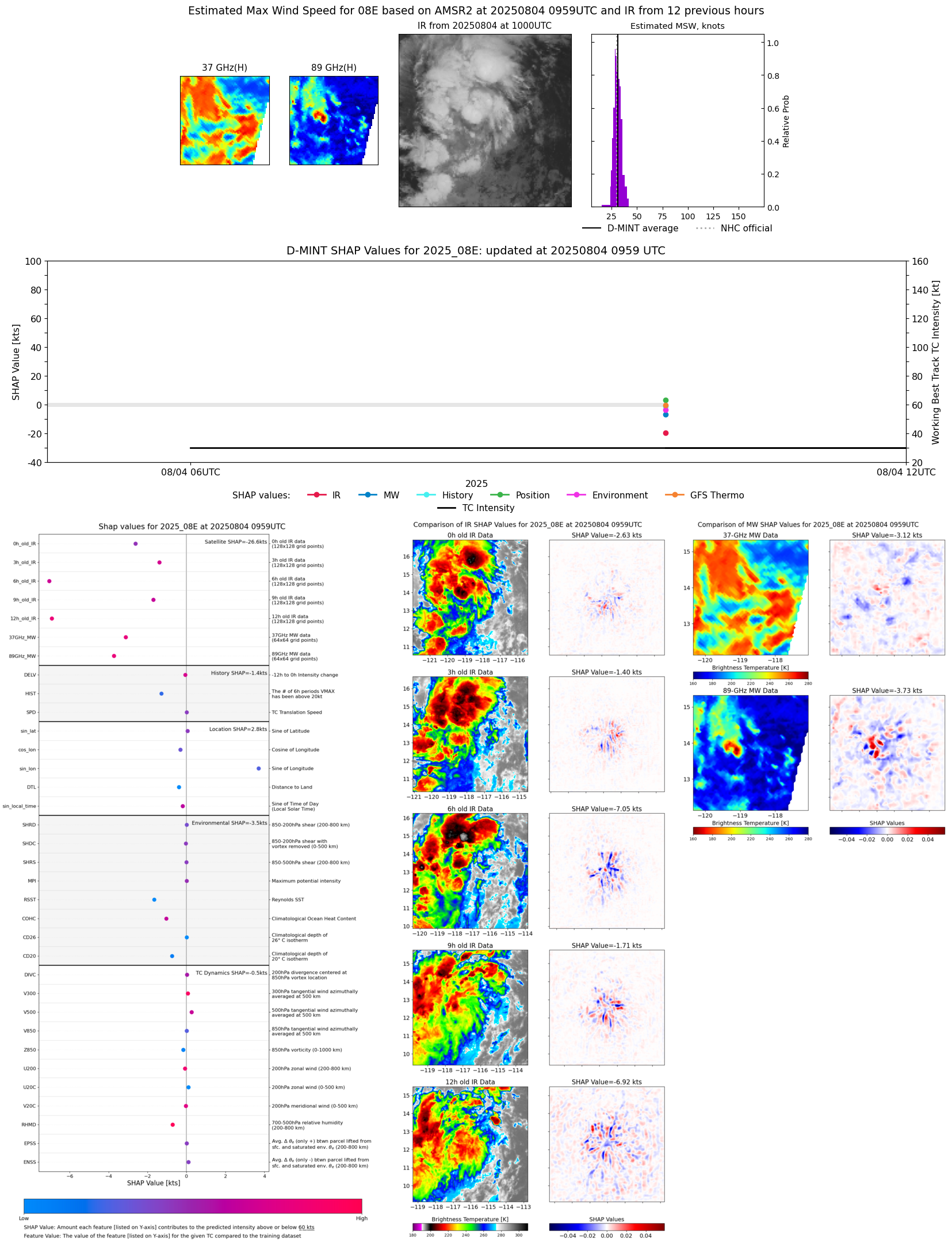 |
| 20250804 | 0619 UTC | TMS02 | 1007 hPa | 34 kts | 30 kts | 38 kts |  |
| 20250804 | 0225 UTC | SSMISF16 | NaN hPa | 30 kts | 27 kts | 34 kts |  |
| 20250804 | 0203 UTC | SSMISF17 | NaN hPa | 31 kts | 27 kts | 35 kts |  |
| 20250803 | 1802 UTC | GMI | NaN hPa | 27 kts | 24 kts | 30 kts |  |
| 20250803 | 1147 UTC | SSMISF18 | NaN hPa | 24 kts | 21 kts | 27 kts |  |
| 20250803 | 0916 UTC | AMSR2 | NaN hPa | 23 kts | 21 kts | 25 kts | 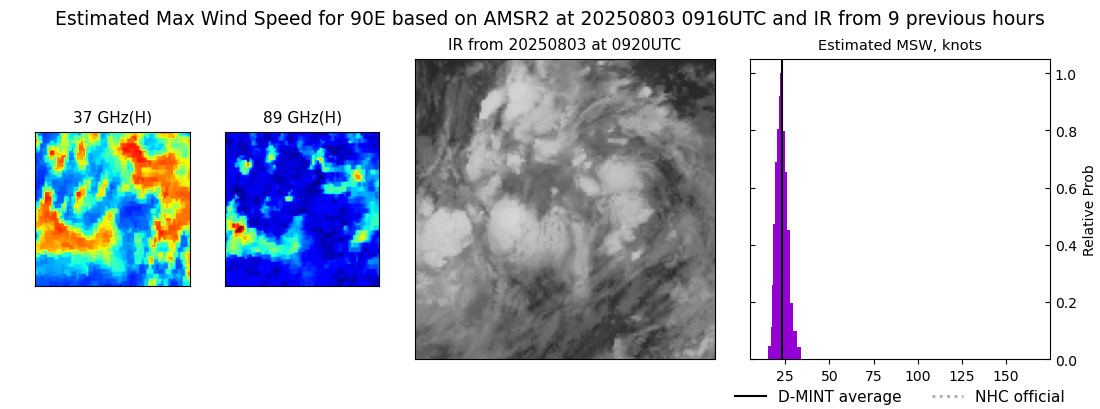 |
| 20250803 | 0629 UTC | GMI | NaN hPa | 20 kts | 18 kts | 22 kts |  |
| 20250802 | 2311 UTC | SSMISF18 | NaN hPa | 24 kts | 21 kts | 27 kts |  |