|
||

 |
D-MINT HISTORY FILE for 2025_08L
| Date | Time | MW Sensor | MSLP | Vmax (30th-70th percentile average) | Vmax 25th percentile | Vmax 75th percentile | Image |
| 20251001 | 2023 UTC | GMI | 987 hPa | 57 kts | 50 kts | 64 kts |  |
| 20251001 | 1448 UTC | TMS02 | 981 hPa | 56 kts | 50 kts | 62 kts | 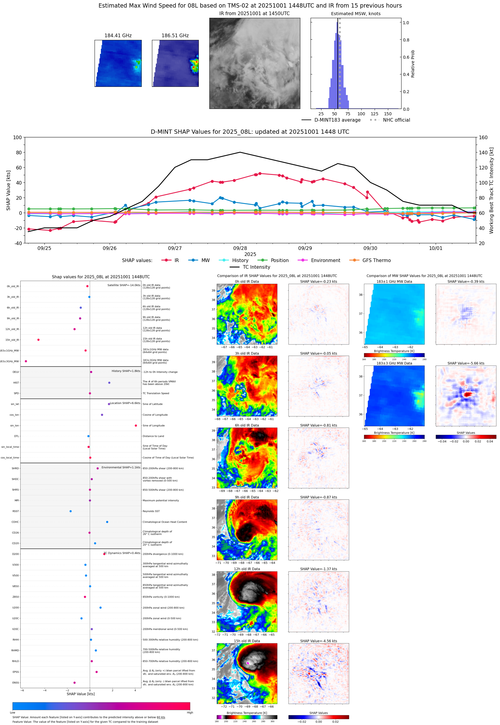 |
| 20251001 | 1410 UTC | TMS05 | 984 hPa | 57 kts | 51 kts | 63 kts | 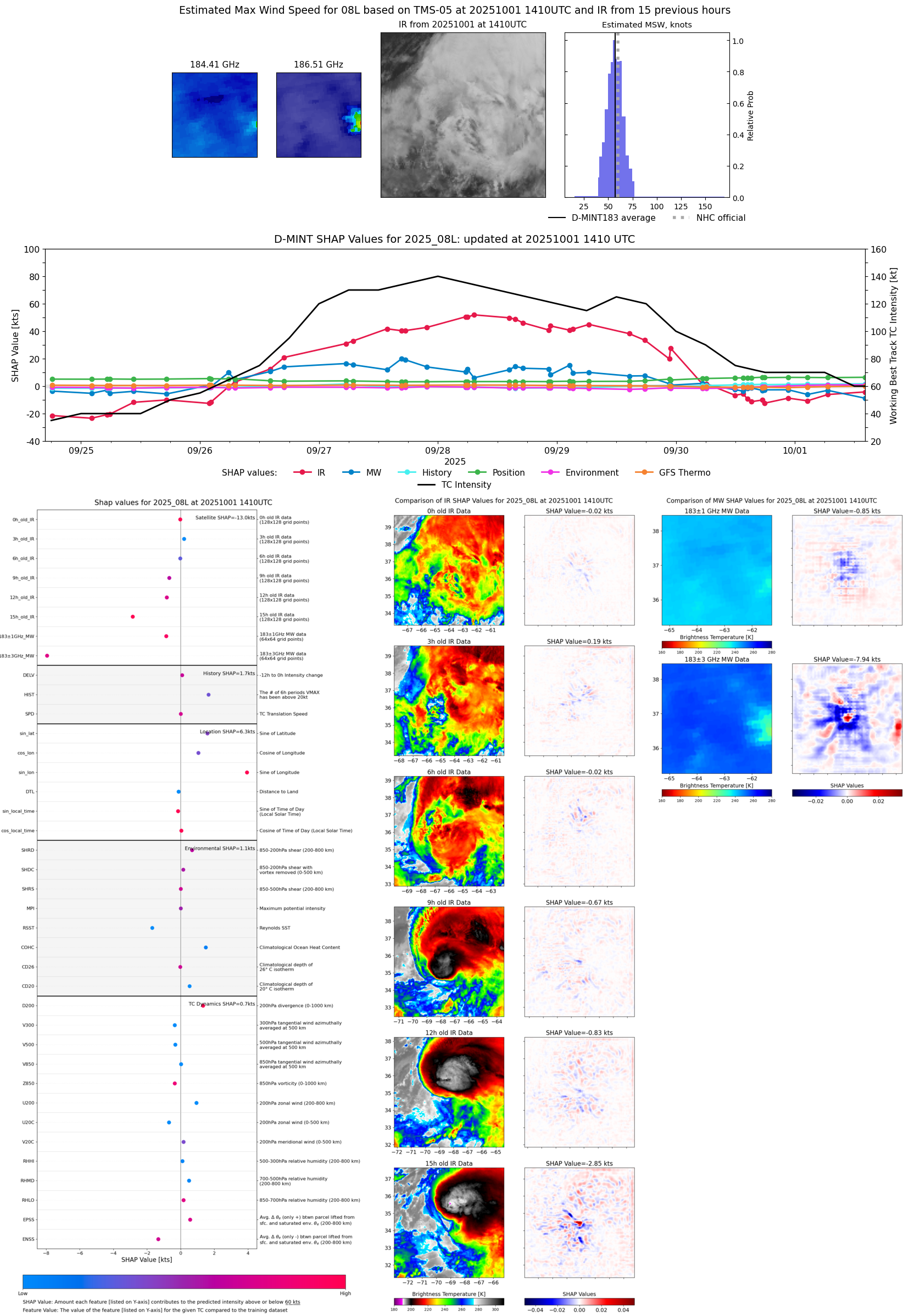 |
| 20251001 | 1053 UTC | SSMISF17 | 978 hPa | 60 kts | 54 kts | 67 kts |  |
| 20251001 | 1021 UTC | WSFM01 | 983 hPa | 55 kts | 50 kts | 61 kts | 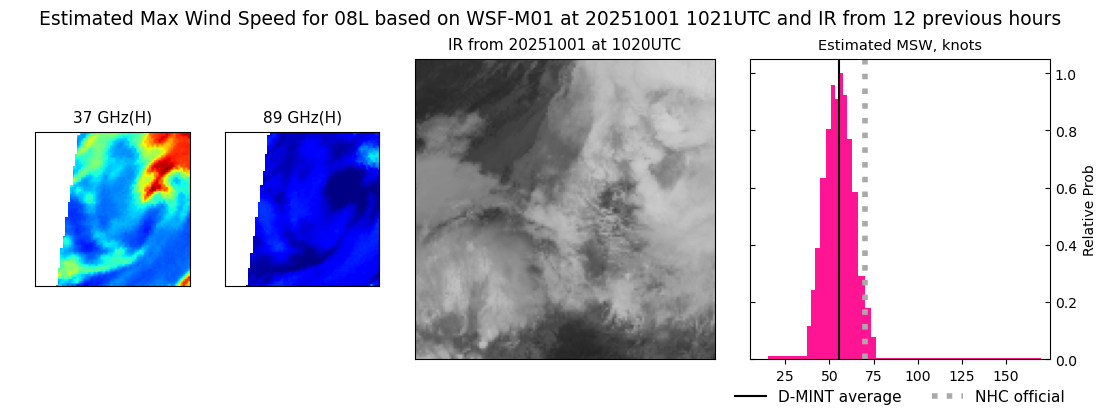 |
| 20251001 | 0638 UTC | ATMS-N20 | 981 hPa | 60 kts | 54 kts | 66 kts | 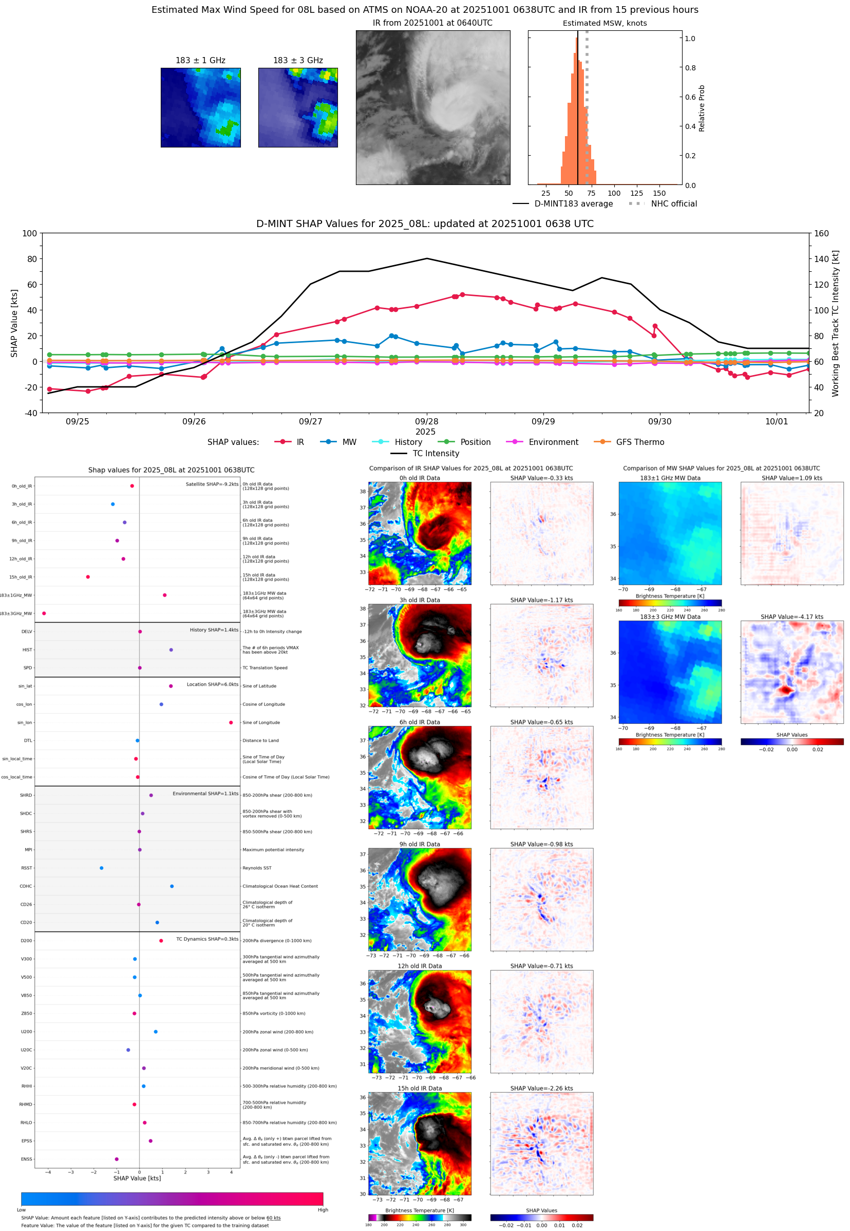 |
| 20251001 | 0233 UTC | AWS | 986 hPa | 52 kts | 47 kts | 57 kts | 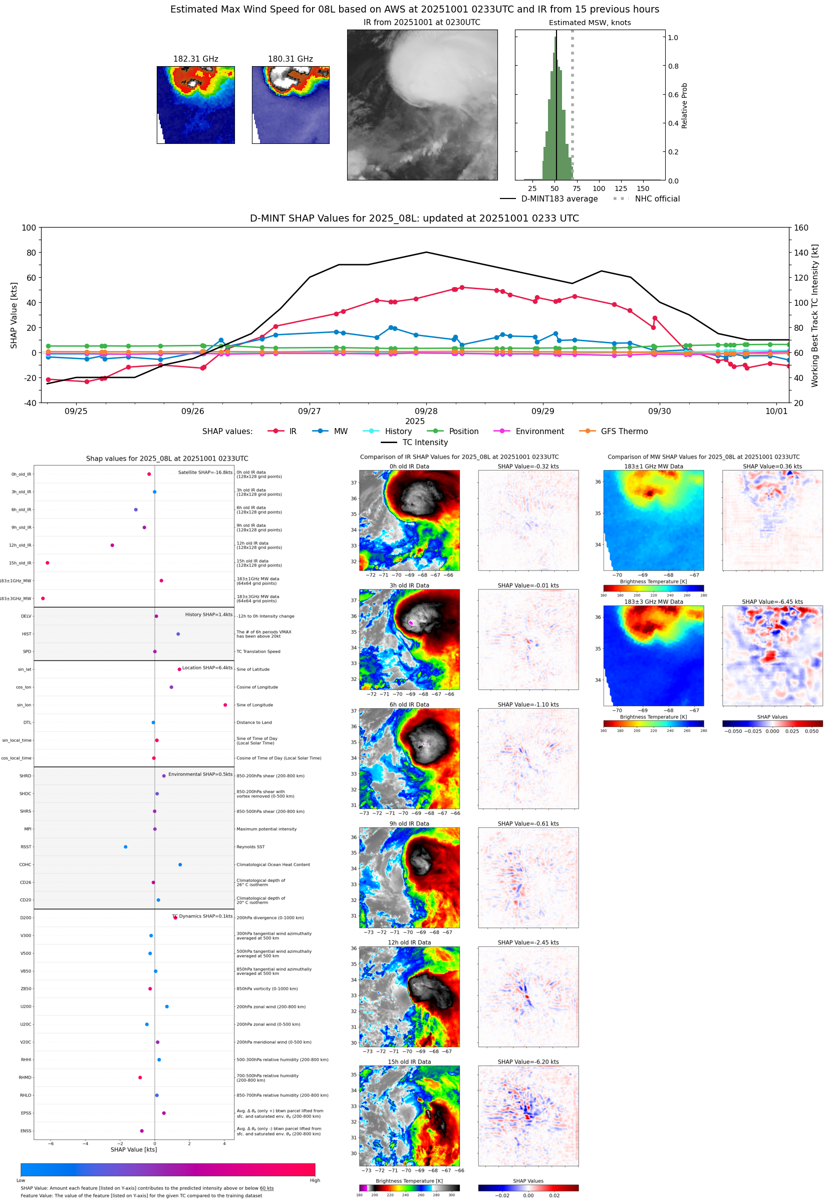 |
| 20250930 | 2320 UTC | SSMISF16 | 984 hPa | 55 kts | 49 kts | 61 kts | 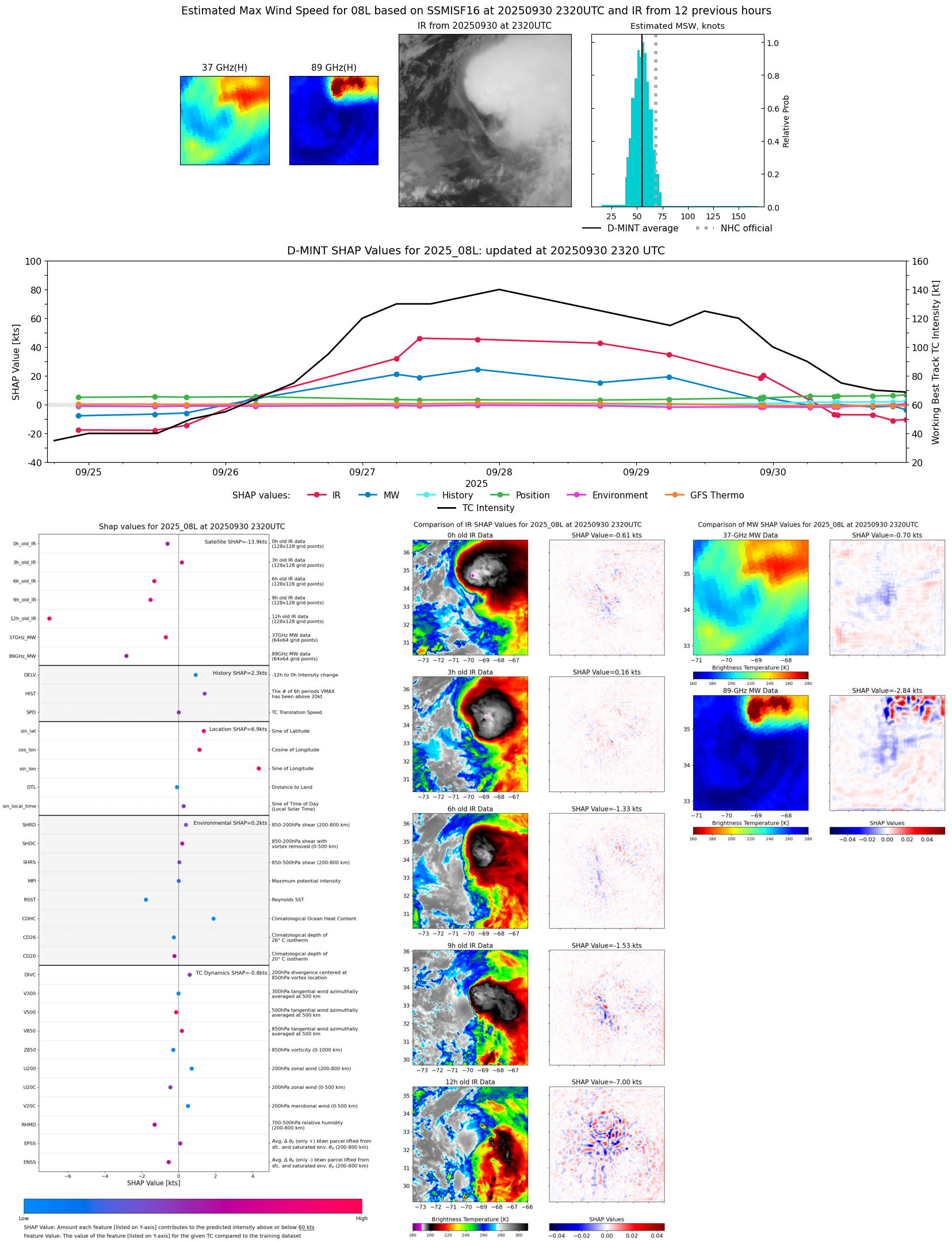 |
| 20250930 | 2241 UTC | TMS07 | 986 hPa | 56 kts | 51 kts | 61 kts | 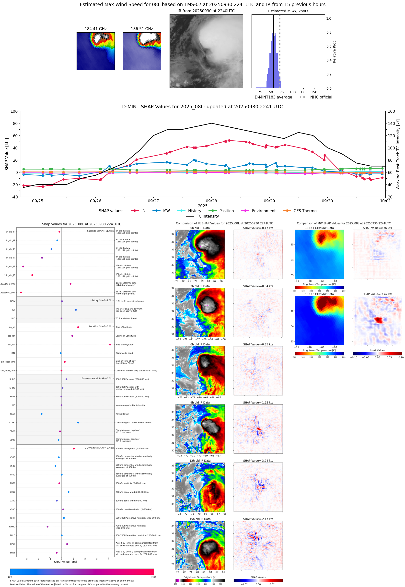 |
| 20250930 | 2200 UTC | WSFM01 | 983 hPa | 55 kts | 50 kts | 61 kts | 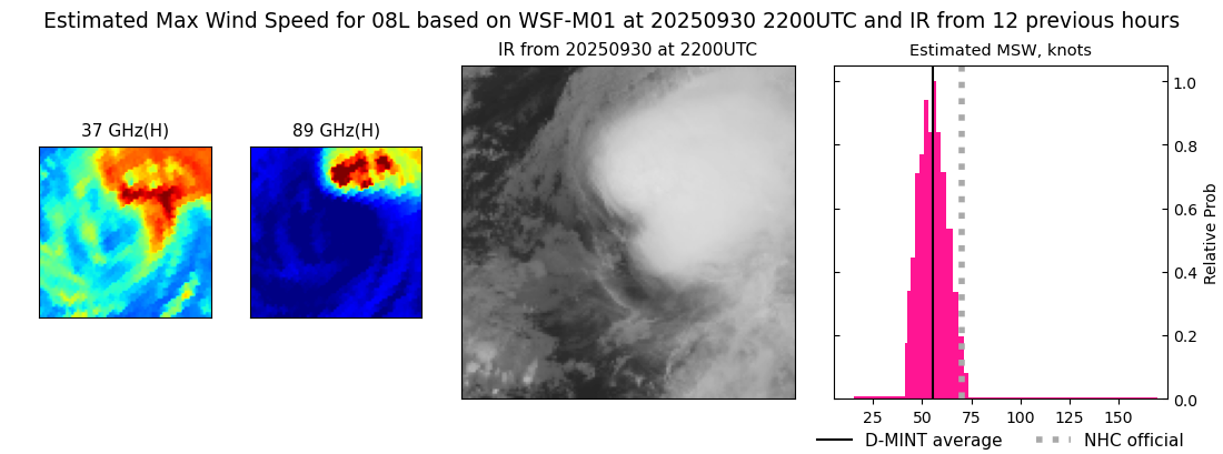 |
| 20250930 | 2103 UTC | GMI | 984 hPa | 55 kts | 50 kts | 61 kts |  |
| 20250930 | 1755 UTC | ATMS-NPP | 986 hPa | 52 kts | 47 kts | 56 kts |  |
| 20250930 | 1731 UTC | AMSR2 | 983 hPa | 58 kts | 52 kts | 63 kts |  |
| 20250930 | 1727 UTC | ATMS-N21 | 986 hPa | 54 kts | 49 kts | 59 kts |  |
| 20250930 | 1516 UTC | TMS02 | 981 hPa | 54 kts | 49 kts | 59 kts |  |
| 20250930 | 1427 UTC | TMS05 | 983 hPa | 56 kts | 50 kts | 61 kts |  |
| 20250930 | 1332 UTC | TROPICS03 | 986 hPa | 57 kts | 51 kts | 62 kts | 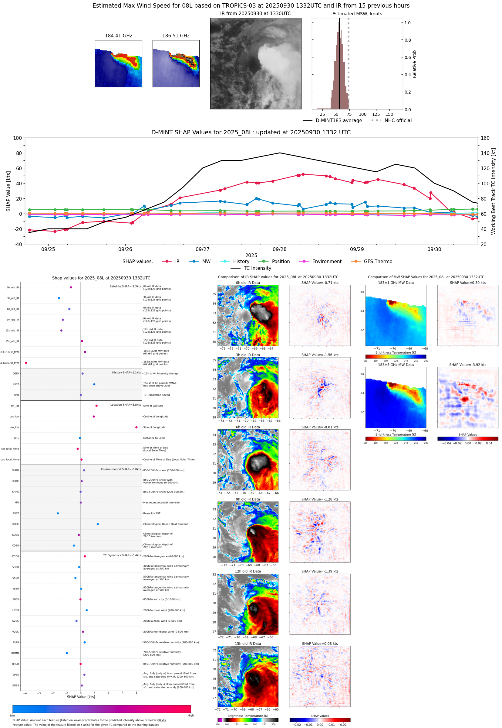 |
| 20250930 | 1155 UTC | TROPICS03 | 984 hPa | 56 kts | 51 kts | 61 kts | 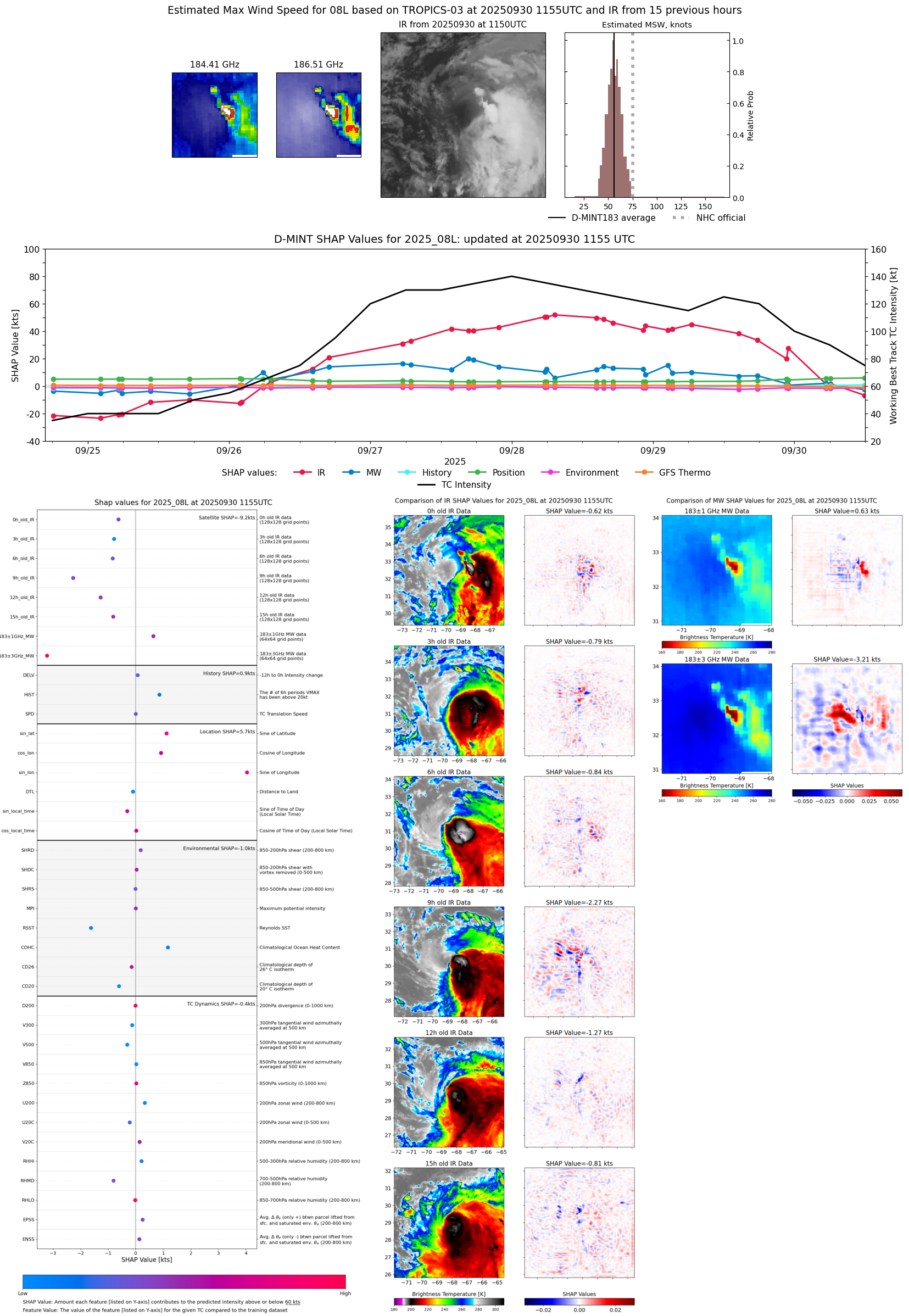 |
| 20250930 | 1118 UTC | GMI | 983 hPa | 58 kts | 53 kts | 64 kts | 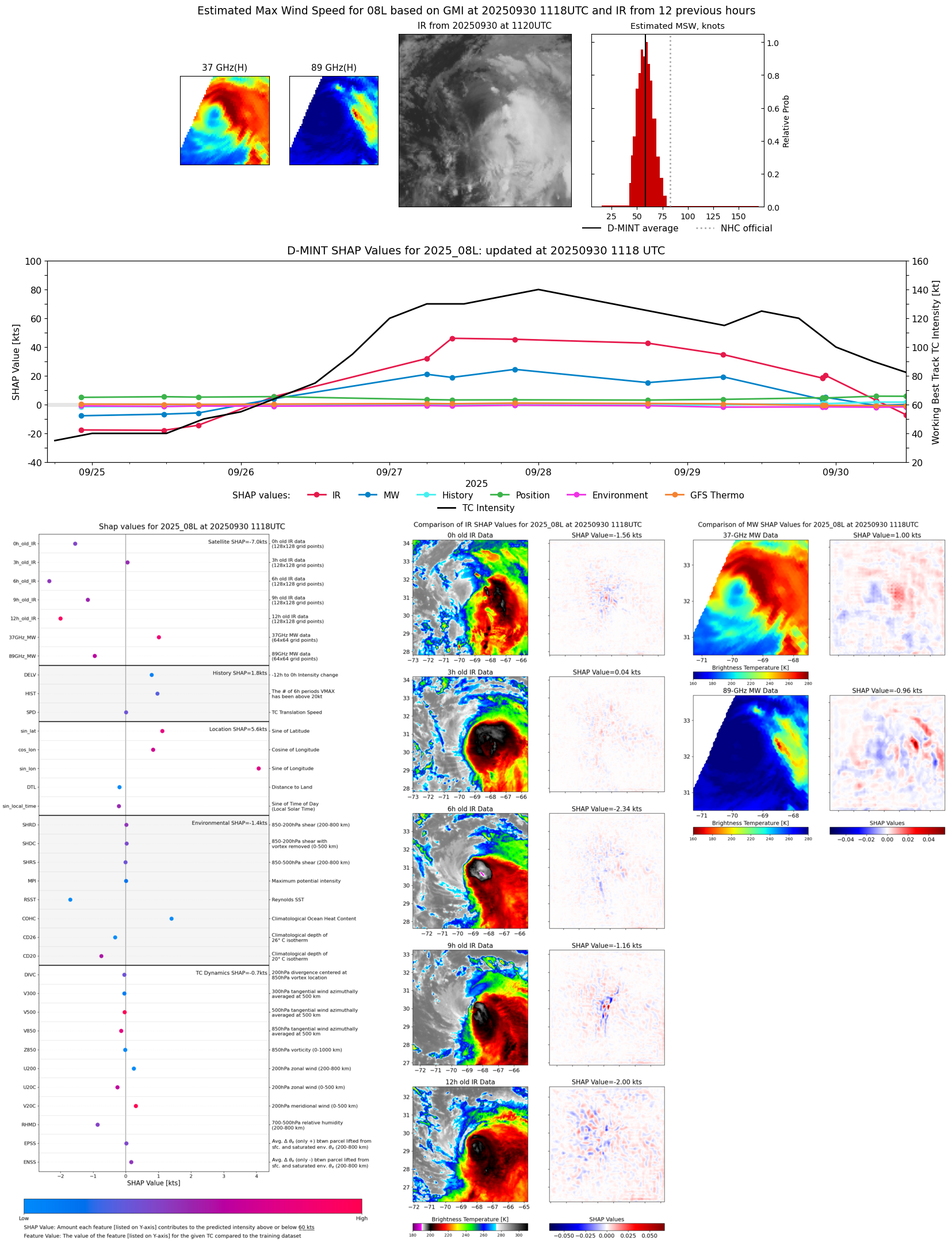 |
| 20250930 | 1042 UTC | WSFM01 | 983 hPa | 58 kts | 53 kts | 64 kts |  |
| 20250930 | 0630 UTC | AMSR2 | 976 hPa | 68 kts | 61 kts | 74 kts | 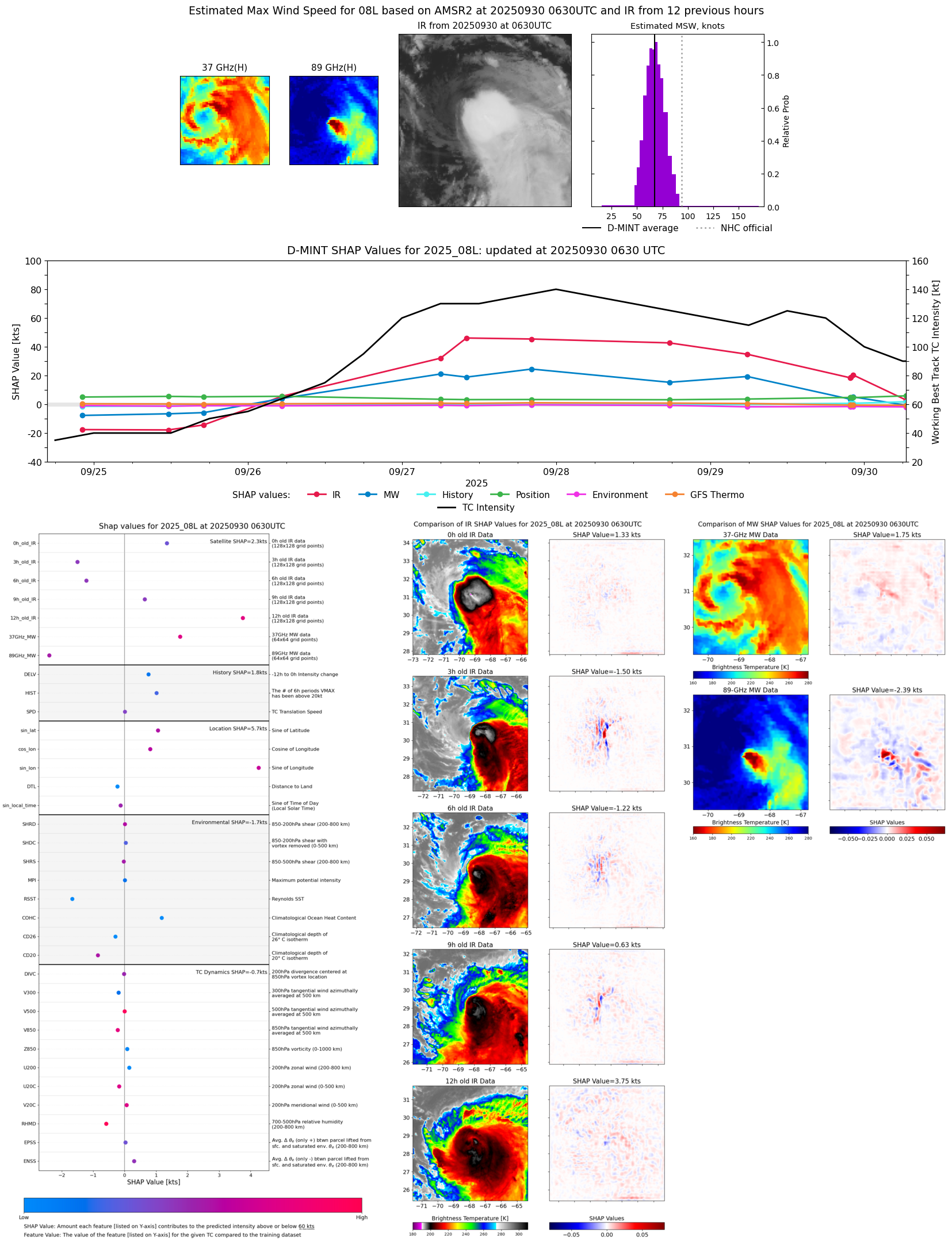 |
| 20250930 | 0610 UTC | ATMS-N21 | 980 hPa | 67 kts | 61 kts | 73 kts |  |
| 20250930 | 0522 UTC | TMS07 | 979 hPa | 67 kts | 62 kts | 73 kts | 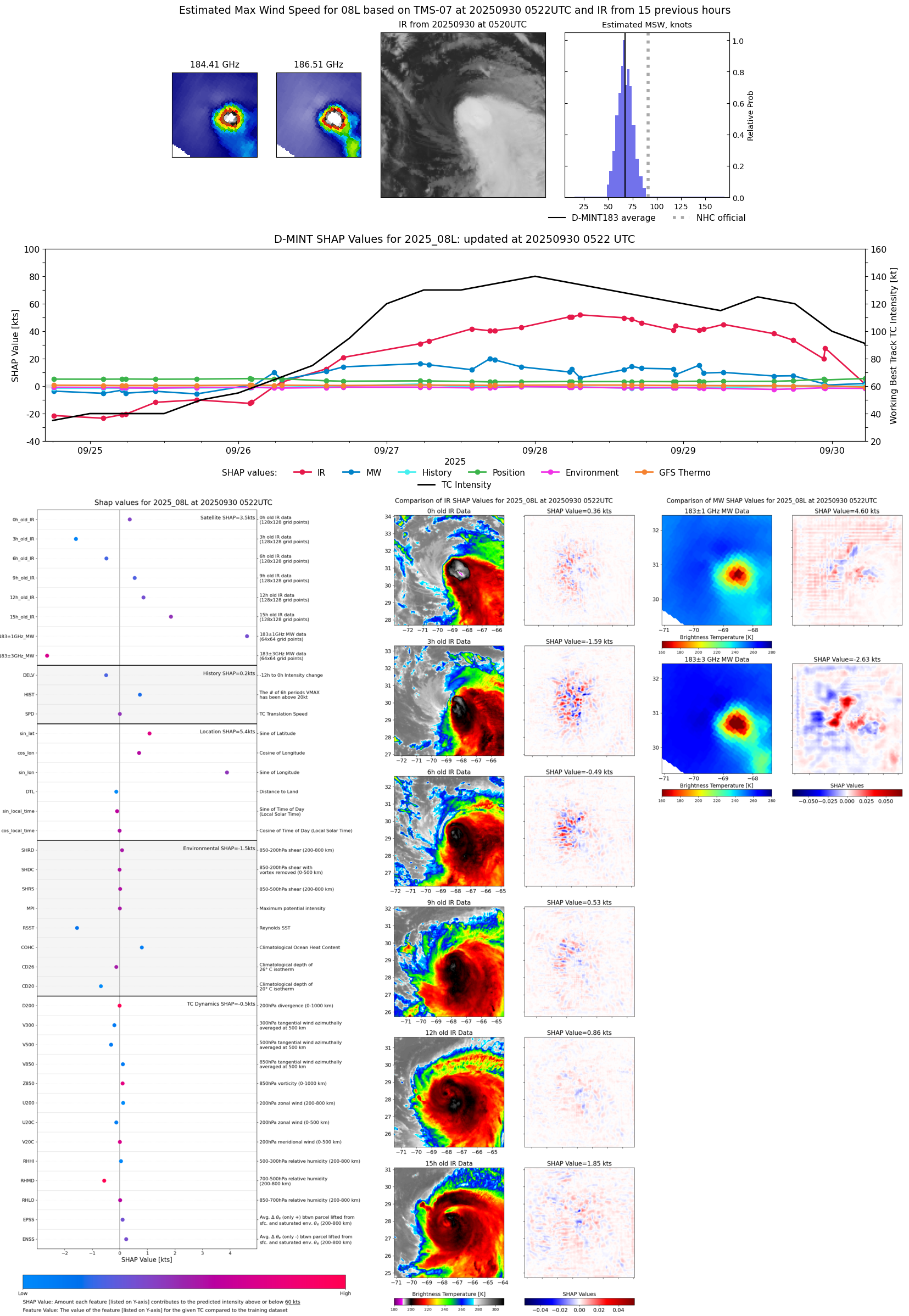 |
| 20250929 | 2255 UTC | TROPICS05 | 964 hPa | 91 kts | 85 kts | 98 kts |  |
| 20250929 | 2241 UTC | TMS07 | 969 hPa | 86 kts | 80 kts | 93 kts | 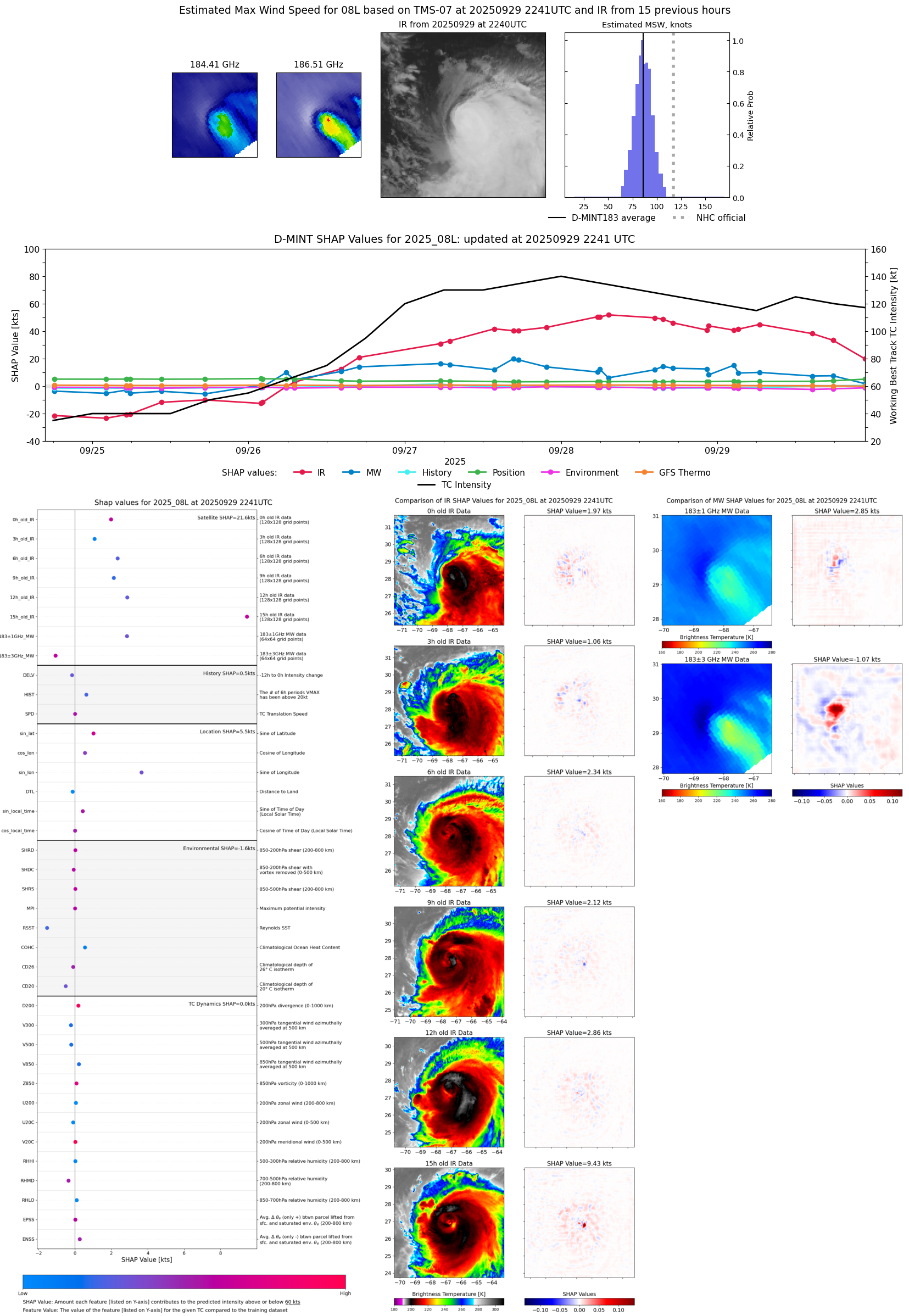 |
| 20250929 | 2218 UTC | WSFM01 | 971 hPa | 89 kts | 82 kts | 96 kts | 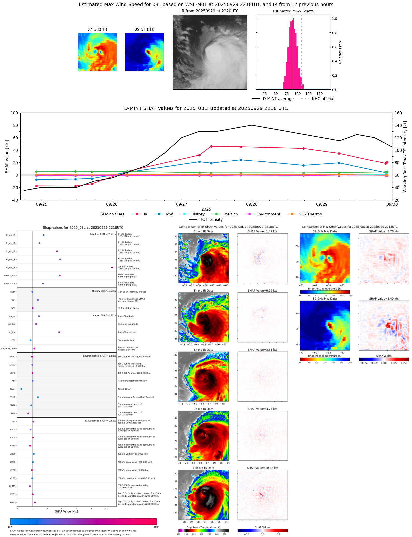 |
| 20250929 | 2152 UTC | GMI | 977 hPa | 85 kts | 79 kts | 92 kts | 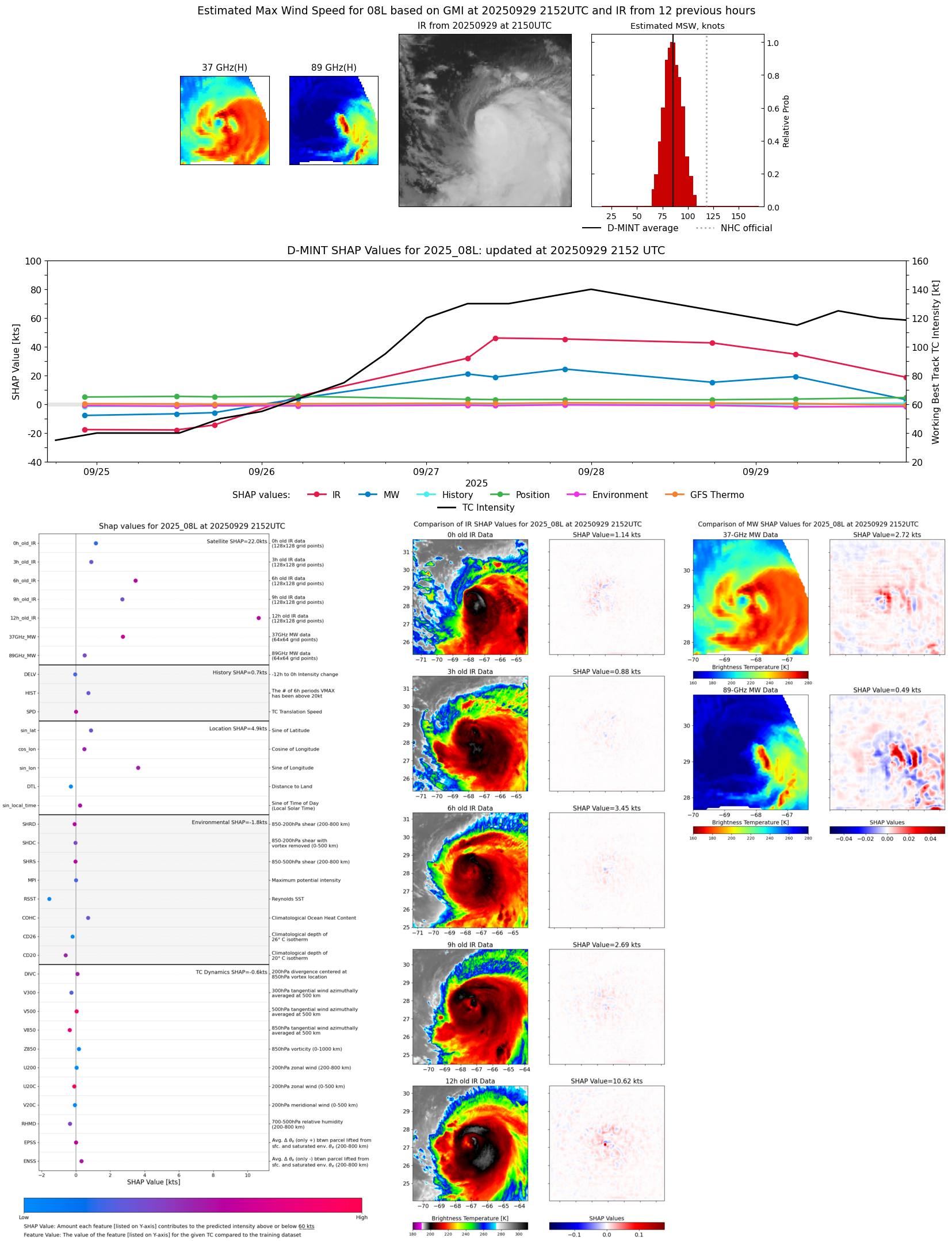 |
| 20250929 | 2148 UTC | GMI | 979 hPa | 85 kts | 79 kts | 92 kts | 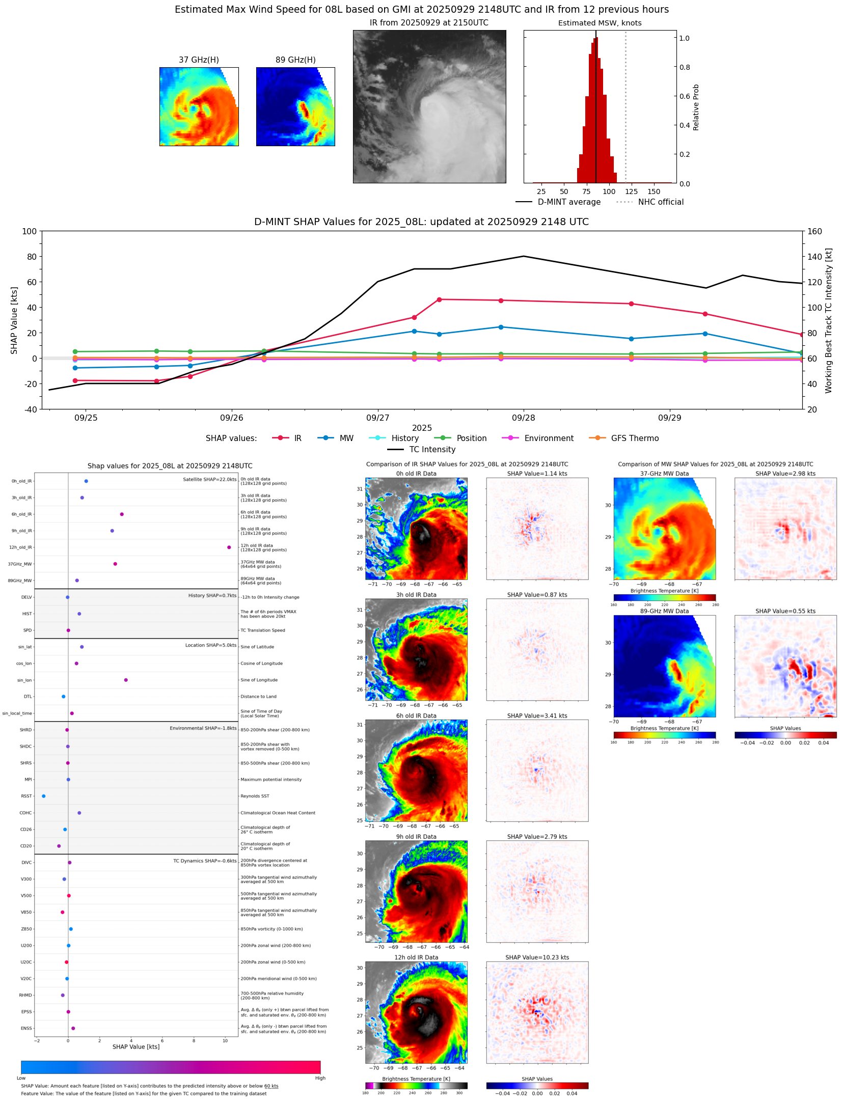 |
| 20250929 | 1745 UTC | ATMS-N21 | 956 hPa | 103 kts | 97 kts | 110 kts |  |
| 20250929 | 1435 UTC | TROPICS03 | 953 hPa | 107 kts | 102 kts | 113 kts | 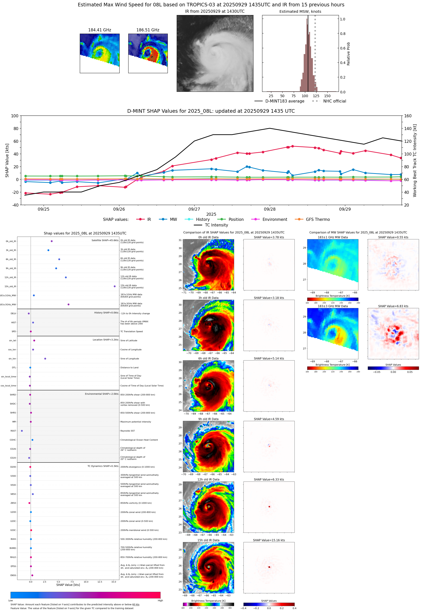 |
| 20250929 | 1103 UTC | WSFM01 | 952 hPa | 116 kts | 110 kts | 122 kts |  |
| 20250929 | 0629 UTC | ATMS-N21 | 944 hPa | 116 kts | 112 kts | 121 kts |  |
| 20250929 | 0548 UTC | AMSR2 | 943 hPa | 117 kts | 110 kts | 123 kts |  |
| 20250929 | 0314 UTC | TROPICS05 | 949 hPa | 112 kts | 108 kts | 117 kts |  |
| 20250929 | 0232 UTC | TMS02 | 948 hPa | 118 kts | 113 kts | 123 kts | 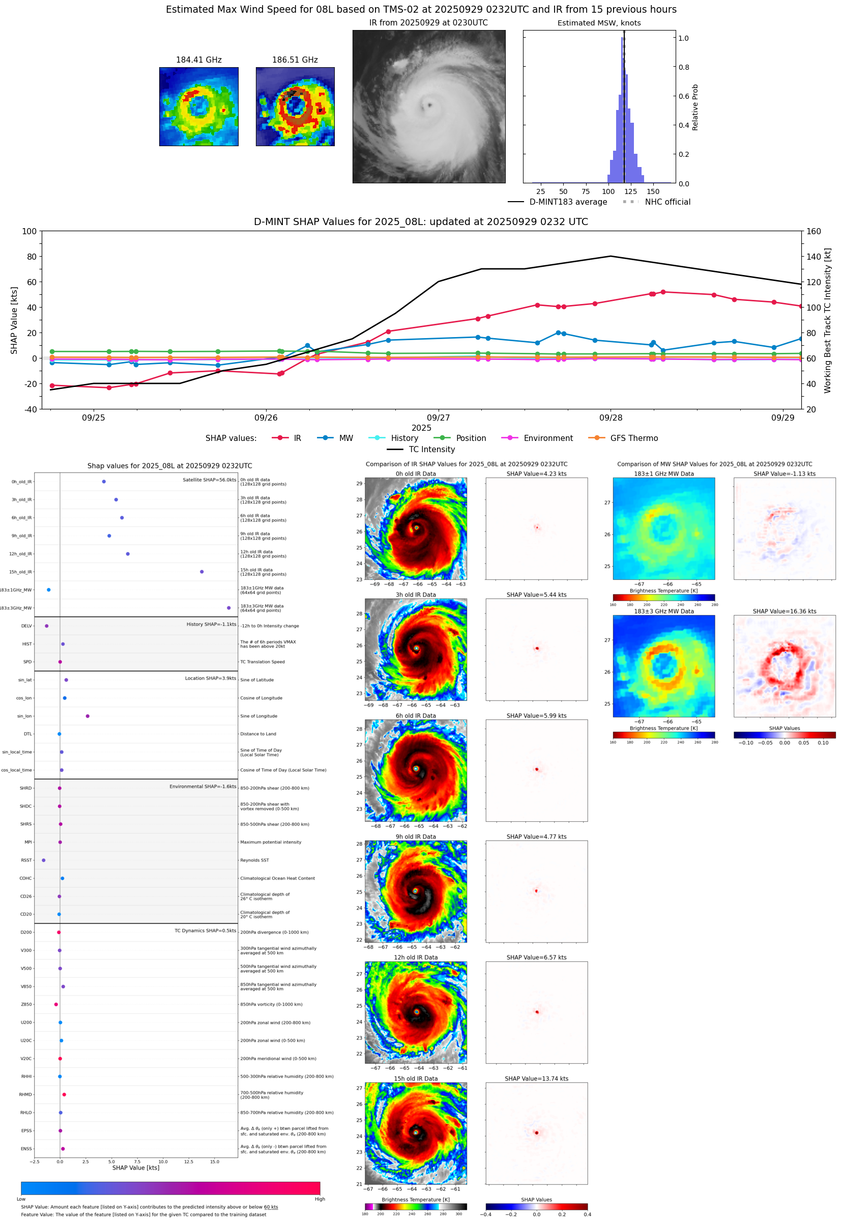 |
| 20250928 | 2241 UTC | TMS07 | 948 hPa | 114 kts | 110 kts | 119 kts | 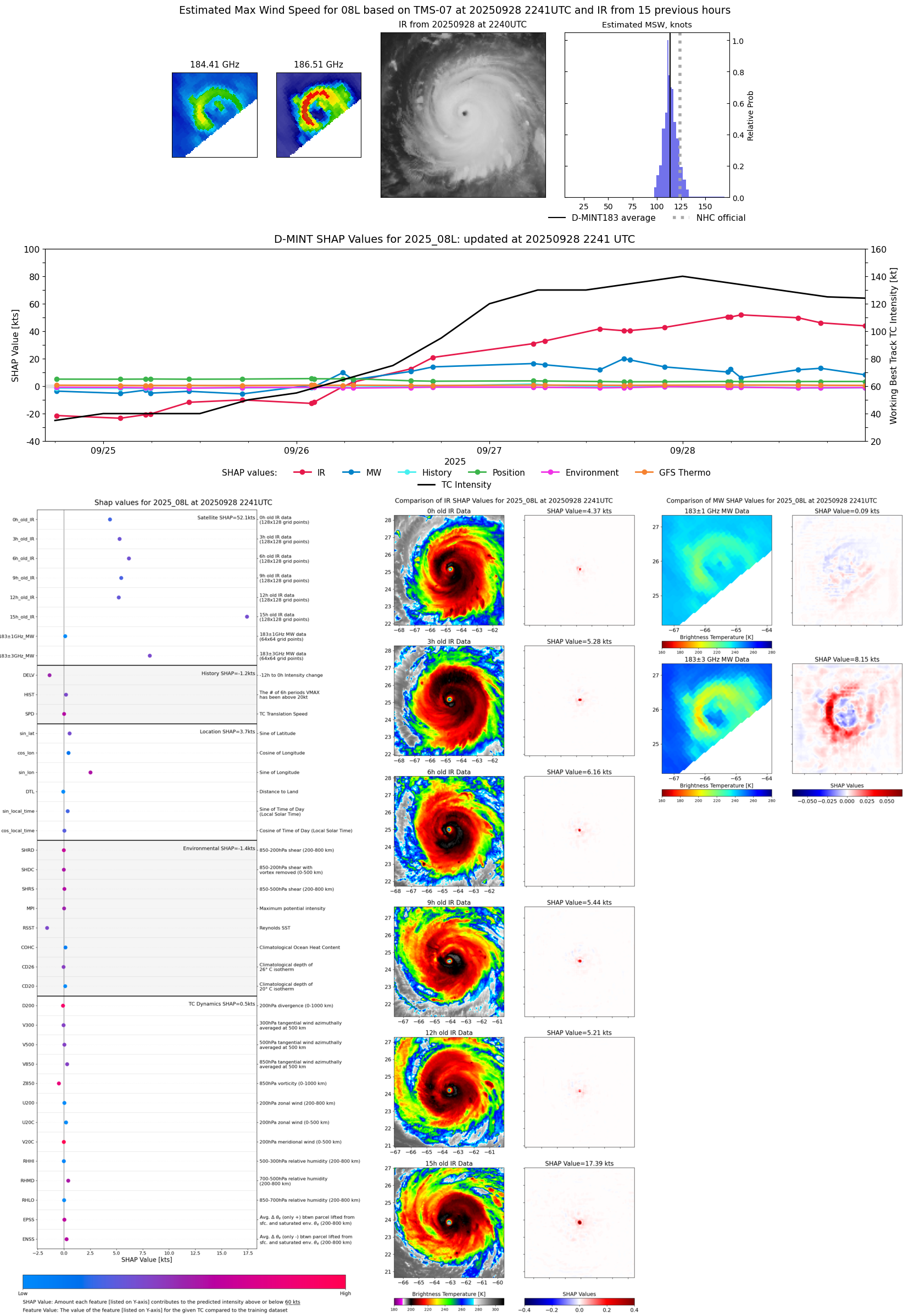 |
| 20250928 | 2222 UTC | TROPICS05 | 945 hPa | 115 kts | 111 kts | 120 kts |  |
| 20250928 | 1740 UTC | AMSR2 | 939 hPa | 121 kts | 115 kts | 125 kts | 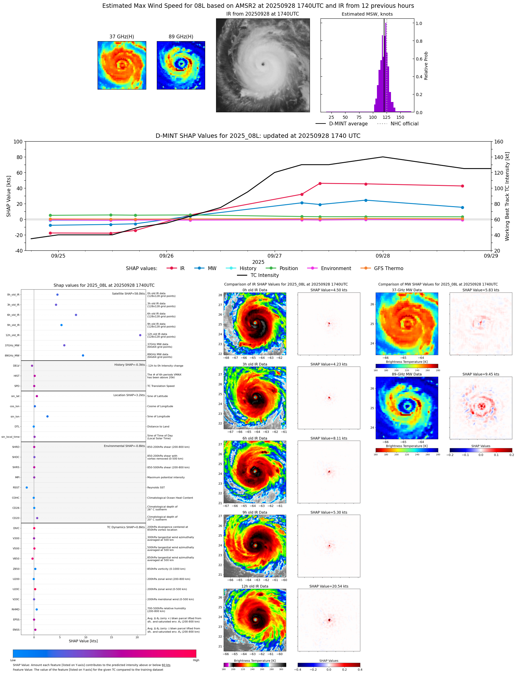 |
| 20250928 | 1711 UTC | ATMS-N20 | 940 hPa | 121 kts | 116 kts | 126 kts |  |
| 20250928 | 1538 UTC | TROPICS03 | 944 hPa | 124 kts | 121 kts | 129 kts | 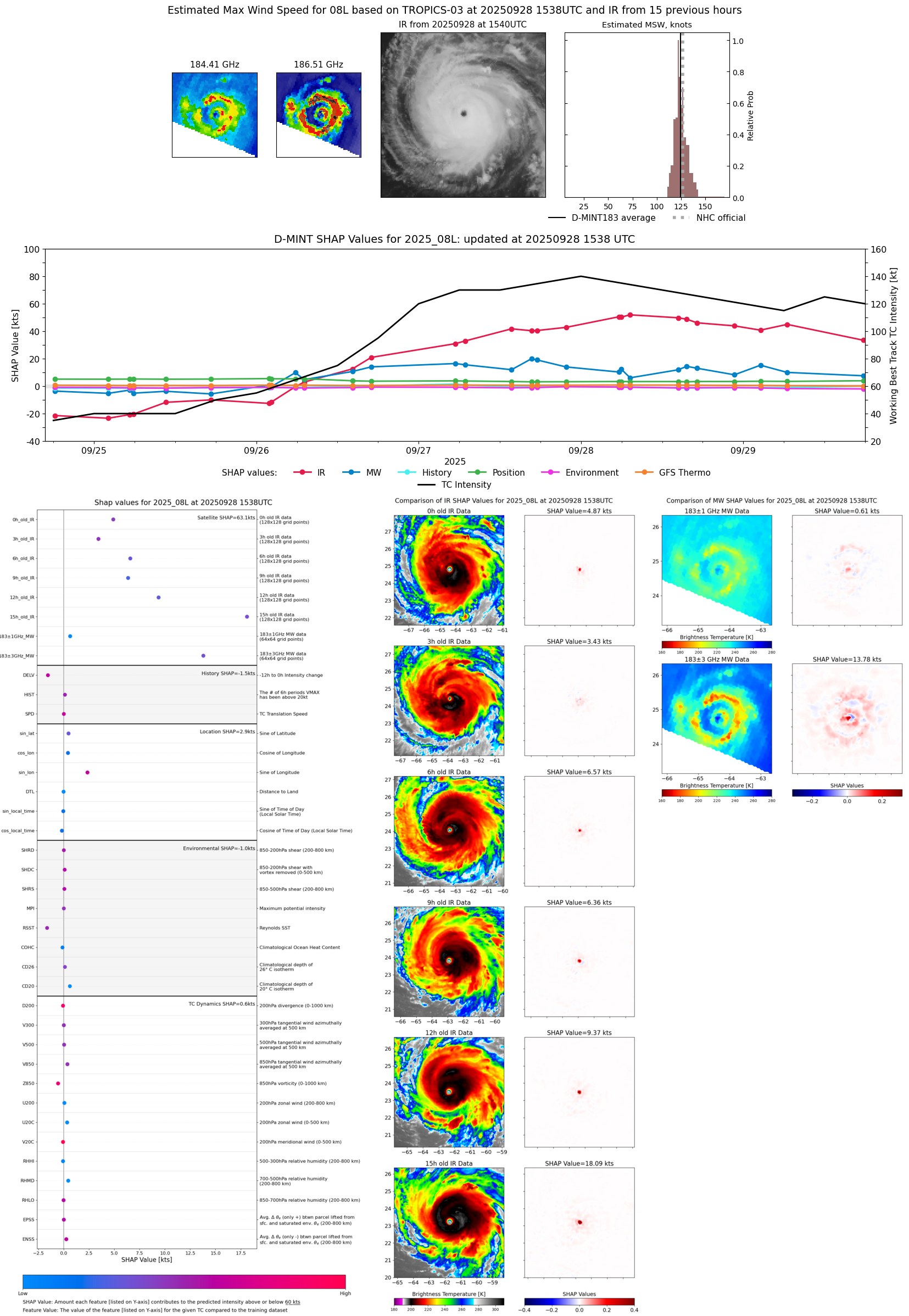 |
| 20250928 | 1422 UTC | TMS06 | 943 hPa | 123 kts | 119 kts | 128 kts | 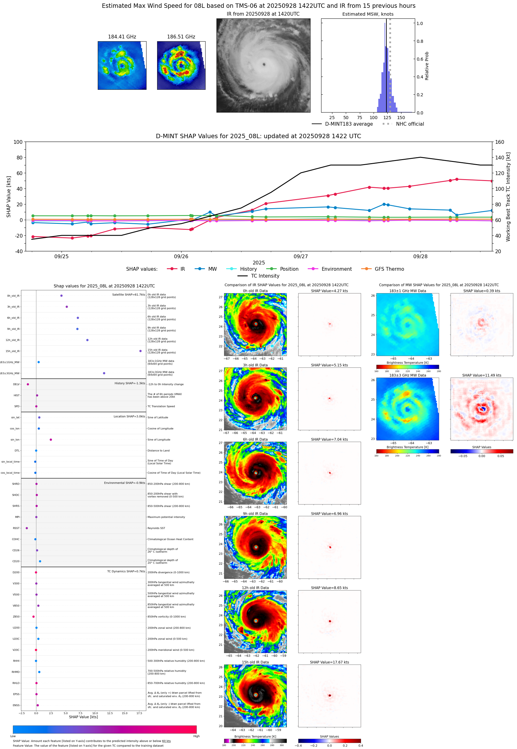 |
| 20250928 | 0716 UTC | TMS07 | 943 hPa | 120 kts | 115 kts | 126 kts |  |
| 20250928 | 0557 UTC | ATMS-N20 | 939 hPa | 125 kts | 120 kts | 131 kts |  |
| 20250928 | 0536 UTC | ATMS-NPP | 940 hPa | 124 kts | 119 kts | 129 kts |  |
| 20250927 | 2148 UTC | TROPICS05 | 942 hPa | 120 kts | 116 kts | 125 kts | 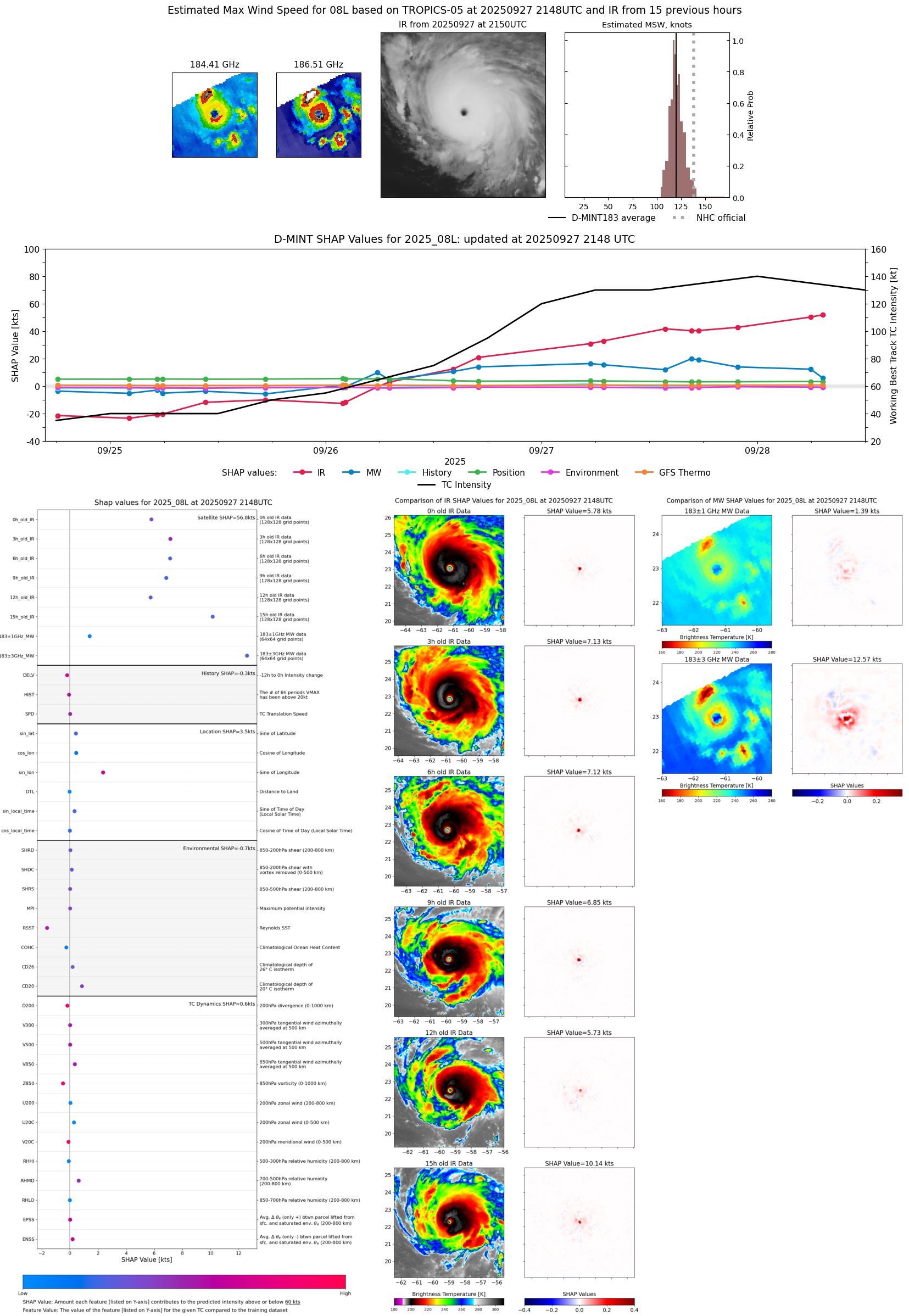 |
| 20250927 | 2138 UTC | GMI | 942 hPa | 128 kts | 121 kts | 134 kts |  |
| 20250927 | 2012 UTC | SSMISF18 | 939 hPa | 133 kts | 126 kts | 140 kts | 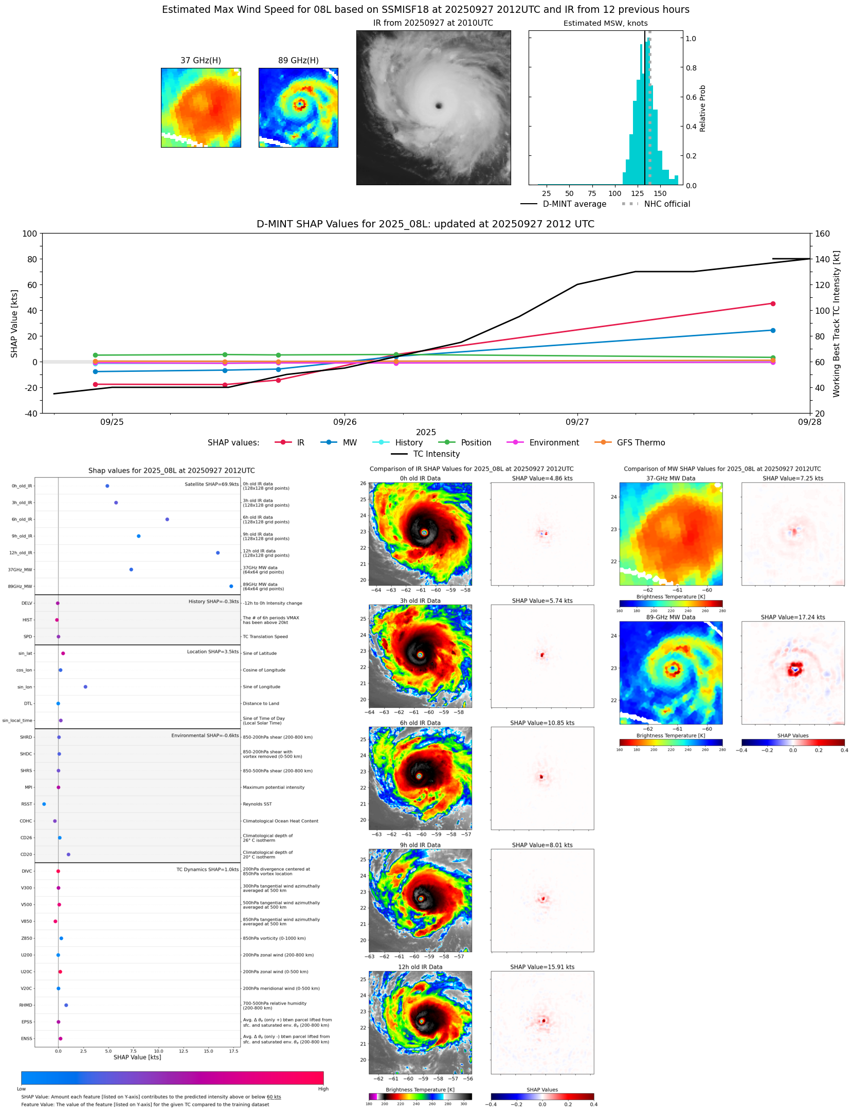 |
| 20250927 | 1729 UTC | ATMS-N20 | 939 hPa | 122 kts | 117 kts | 128 kts |  |
| 20250927 | 1642 UTC | TROPICS03 | 941 hPa | 123 kts | 118 kts | 128 kts |  |
| 20250927 | 1344 UTC | TMS05 | 948 hPa | 116 kts | 111 kts | 121 kts | 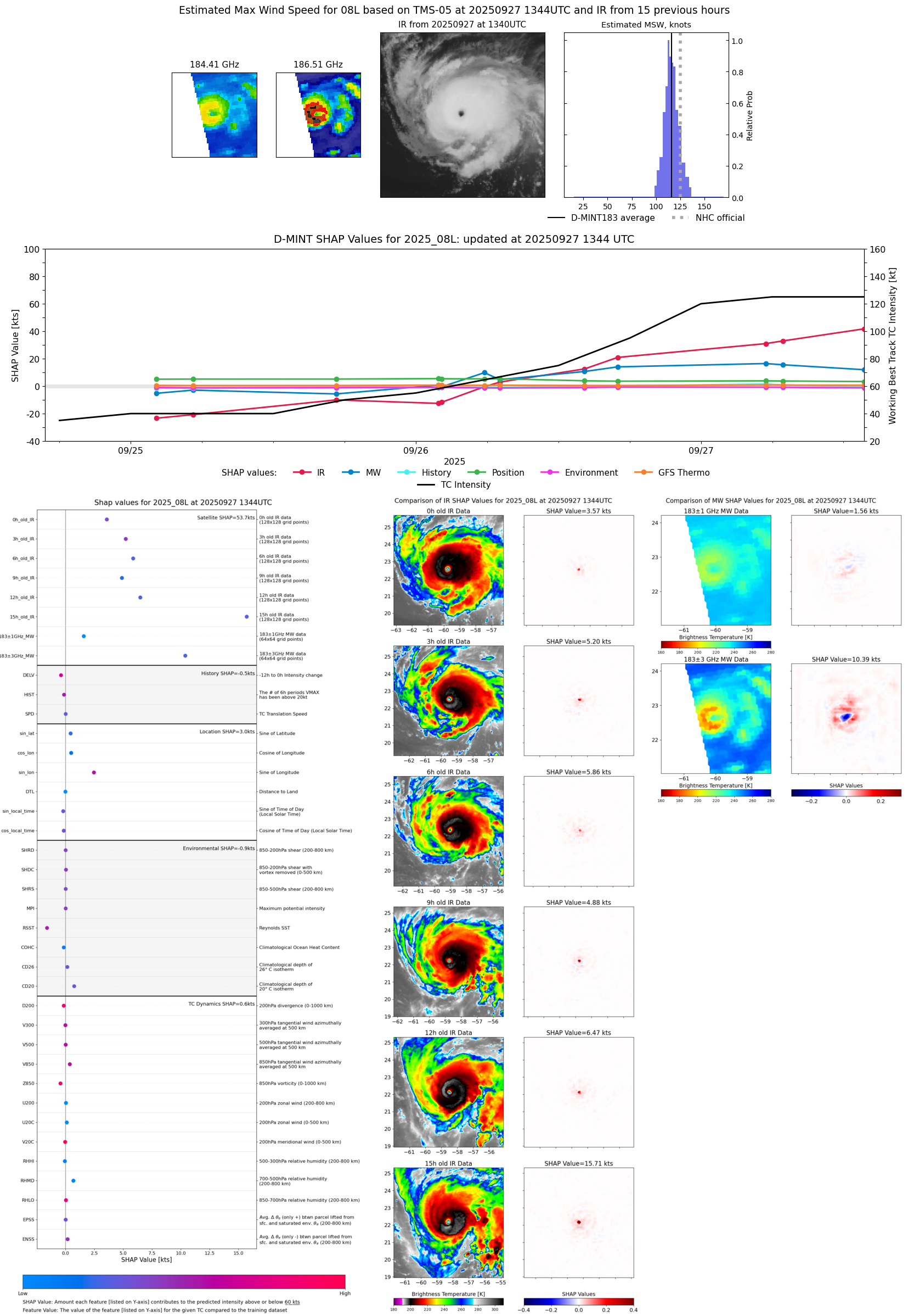 |
| 20250927 | 1003 UTC | WSFM01 | 949 hPa | 127 kts | 121 kts | 134 kts |  |
| 20250927 | 0653 UTC | TMS07 | 947 hPa | 113 kts | 107 kts | 119 kts |  |
| 20250927 | 0601 UTC | AMSR2 | 949 hPa | 117 kts | 110 kts | 123 kts | 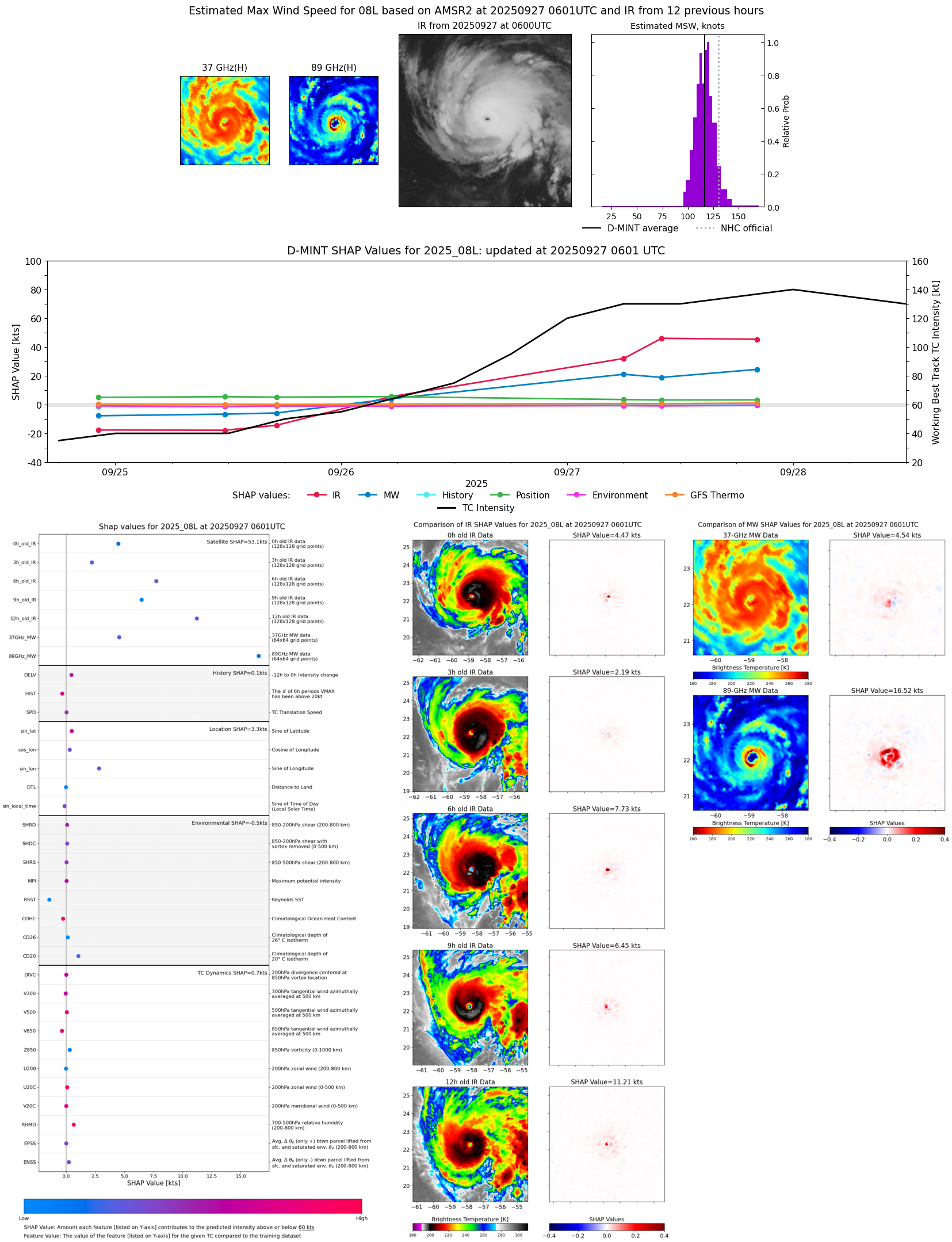 |
| 20250927 | 0527 UTC | ATMS-N21 | 952 hPa | 113 kts | 107 kts | 119 kts | 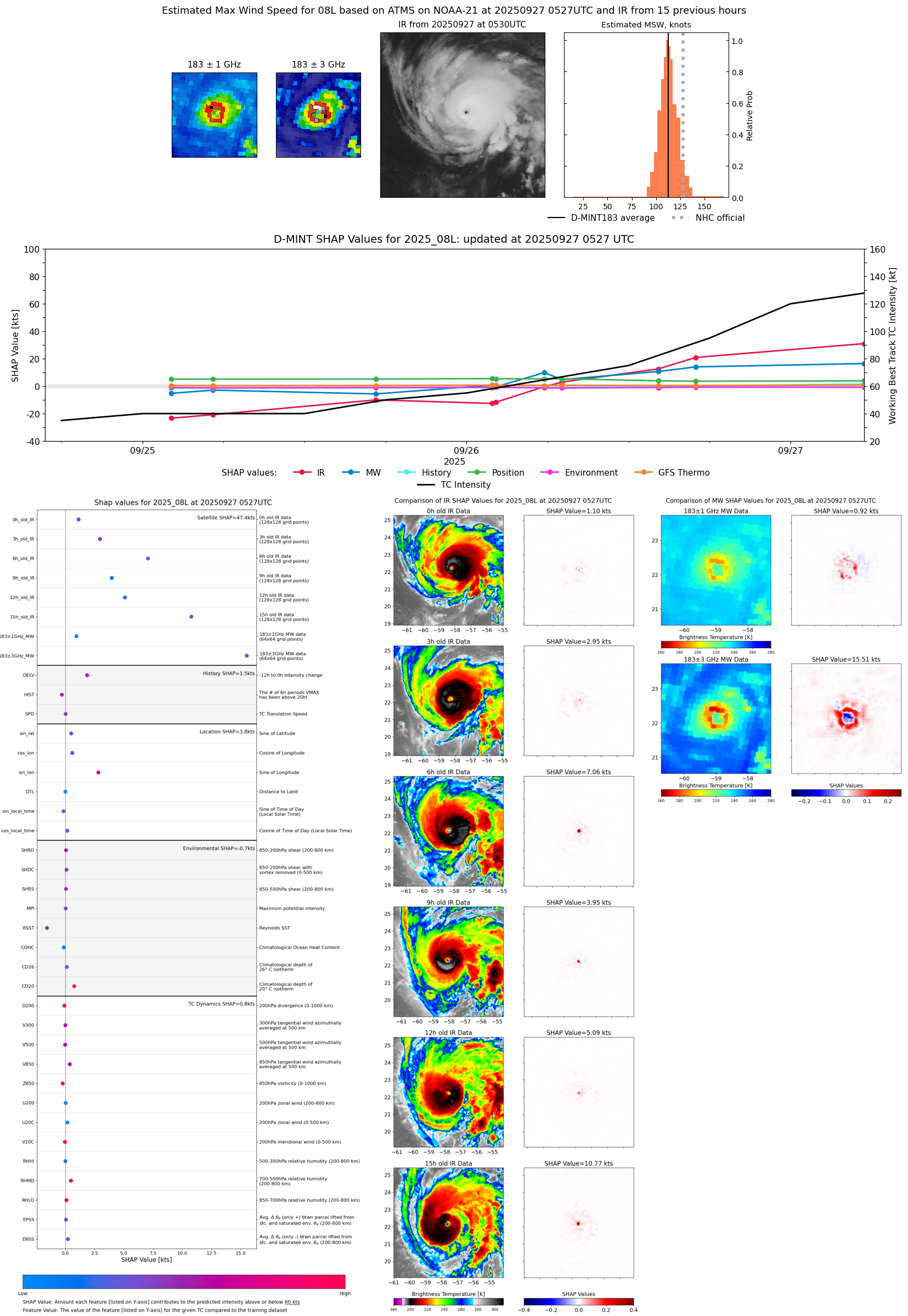 |
| 20250926 | 1659 UTC | ATMS-N21 | 965 hPa | 99 kts | 93 kts | 105 kts |  |
| 20250926 | 1412 UTC | TMS05 | 971 hPa | 87 kts | 81 kts | 93 kts |  |
| 20250926 | 0704 UTC | TMS07 | 991 hPa | 72 kts | 66 kts | 78 kts |  |
| 20250926 | 0546 UTC | ATMS-N21 | 984 hPa | 74 kts | 67 kts | 80 kts |  |
| 20250926 | 0518 UTC | AMSR2 | 990 hPa | 73 kts | 67 kts | 79 kts | 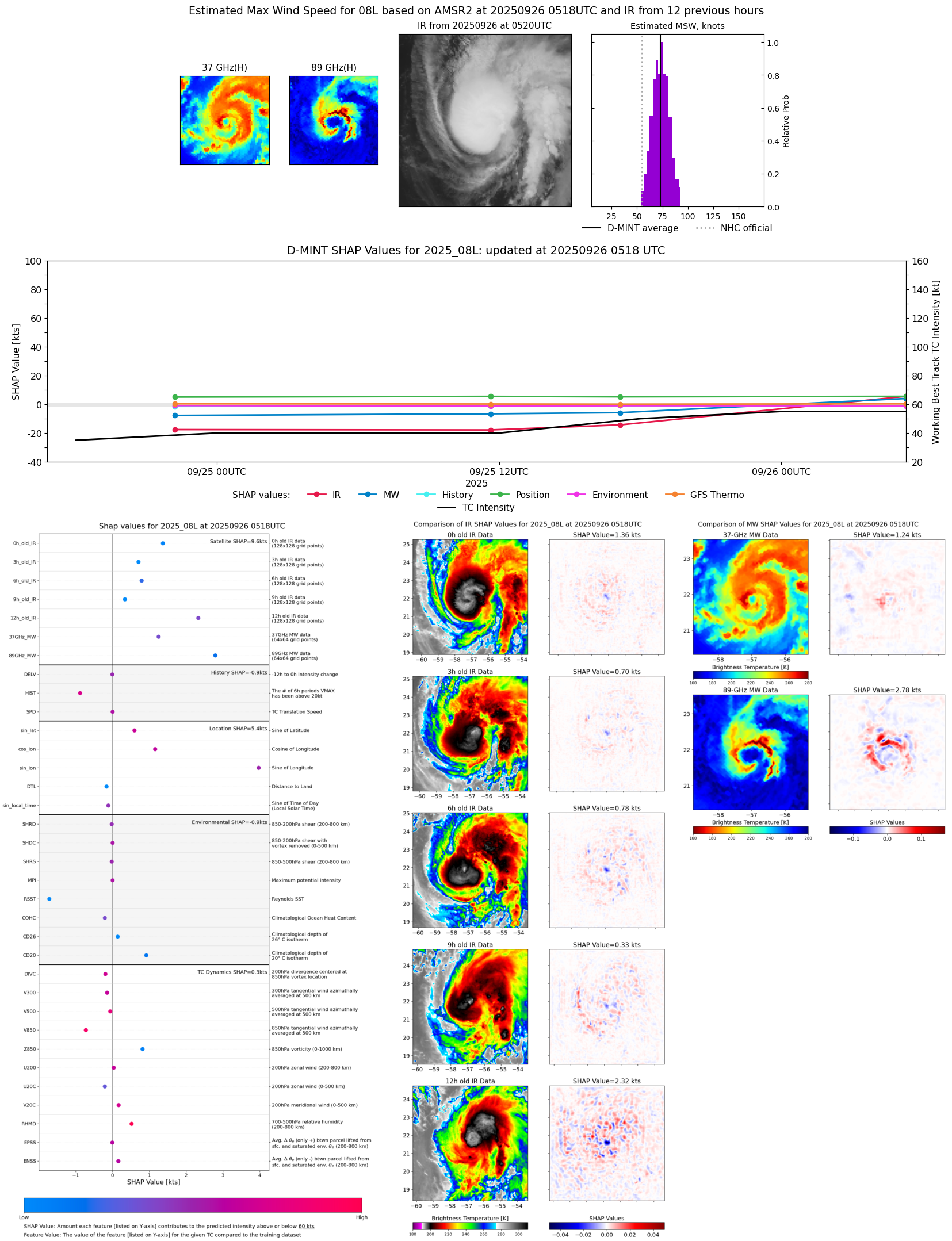 |
| 20250926 | 0211 UTC | TMS02 | 999 hPa | 52 kts | 47 kts | 58 kts | 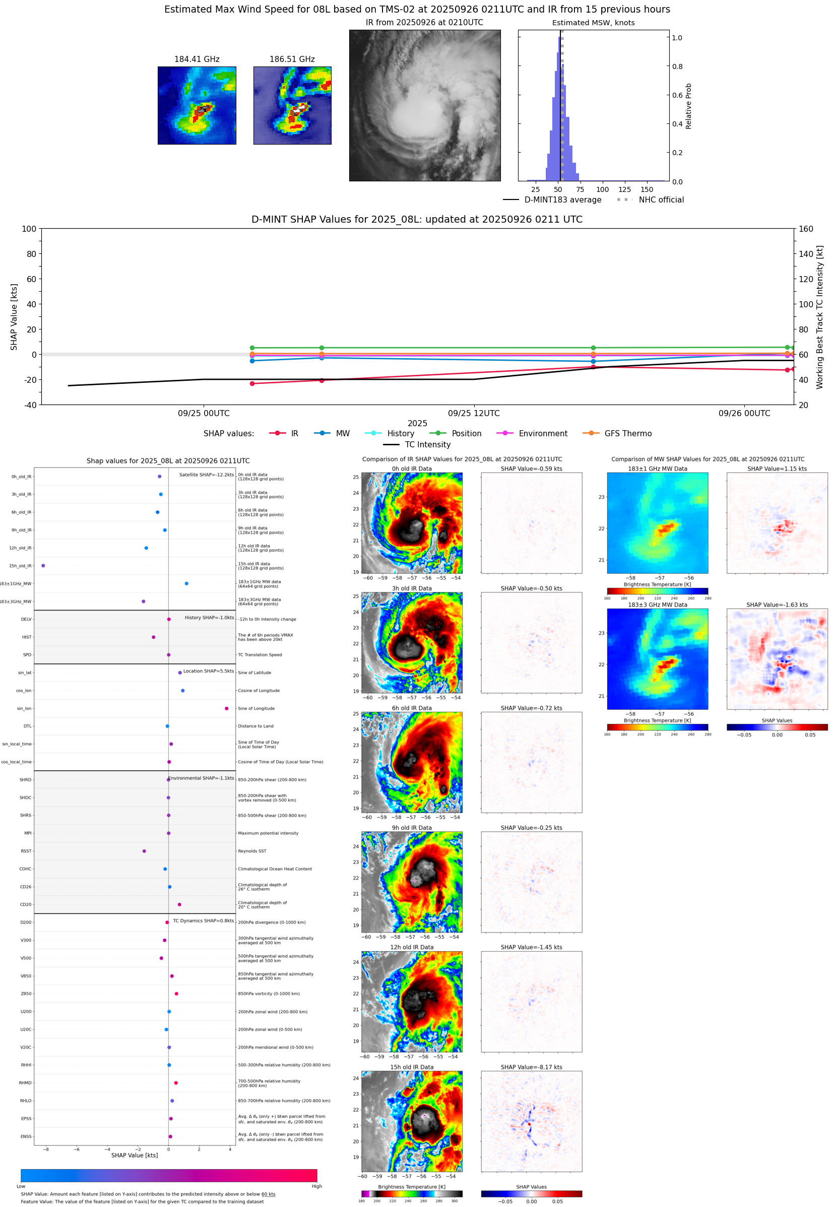 |
| 20250926 | 0153 UTC | TMS05 | 1001 hPa | 53 kts | 48 kts | 58 kts | 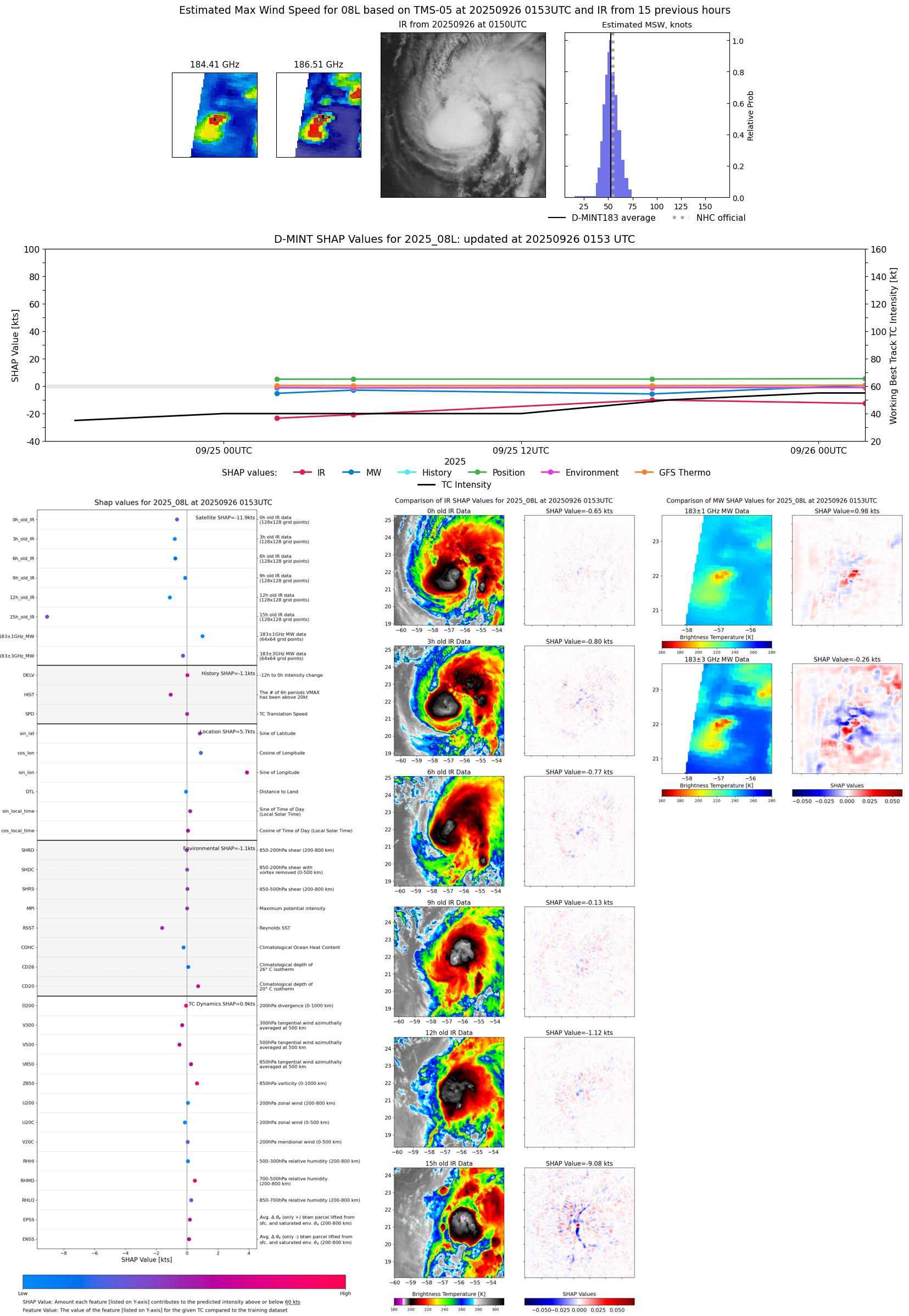 |
| 20250925 | 1717 UTC | ATMS-N21 | 1005 hPa | 48 kts | 44 kts | 52 kts | 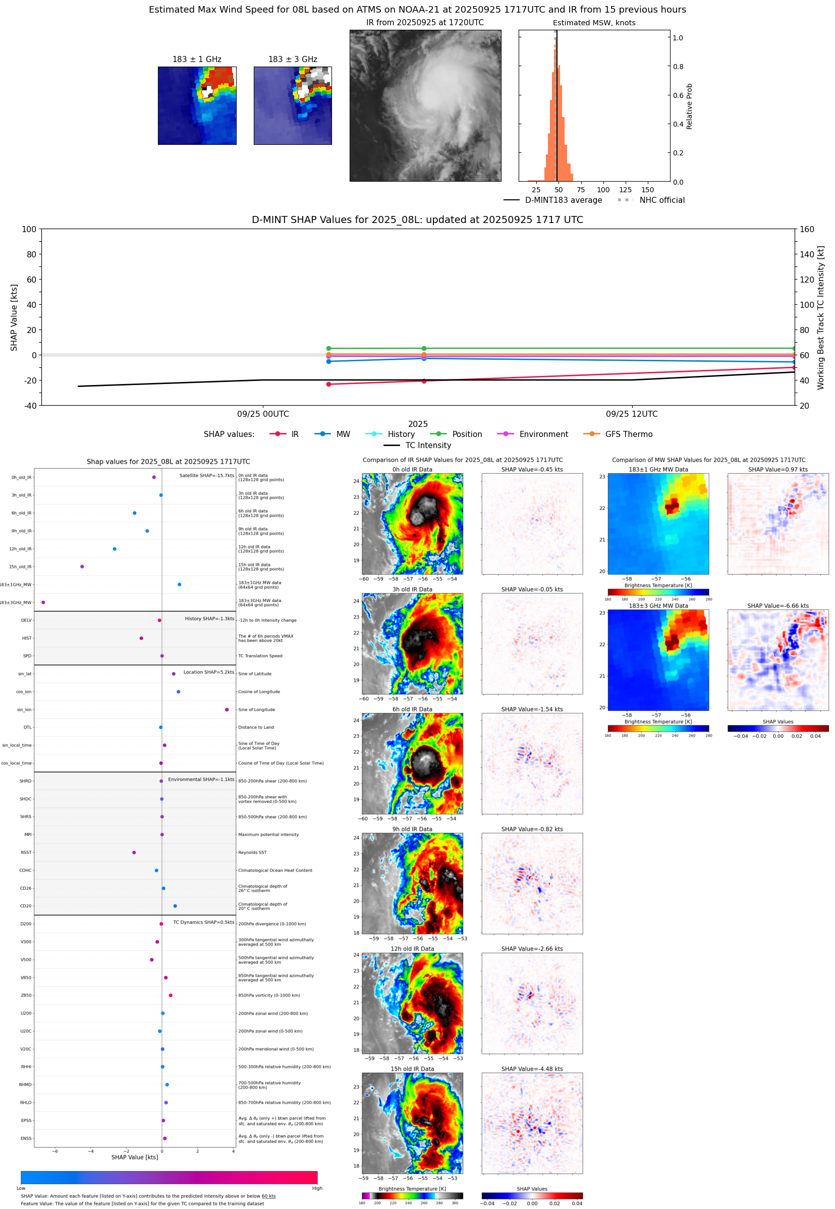 |
| 20250925 | 1708 UTC | AMSR2 | 1007 hPa | 43 kts | 39 kts | 48 kts |  |
| 20250925 | 1408 UTC | TMS02 | 1004 hPa | 45 kts | 41 kts | 50 kts | 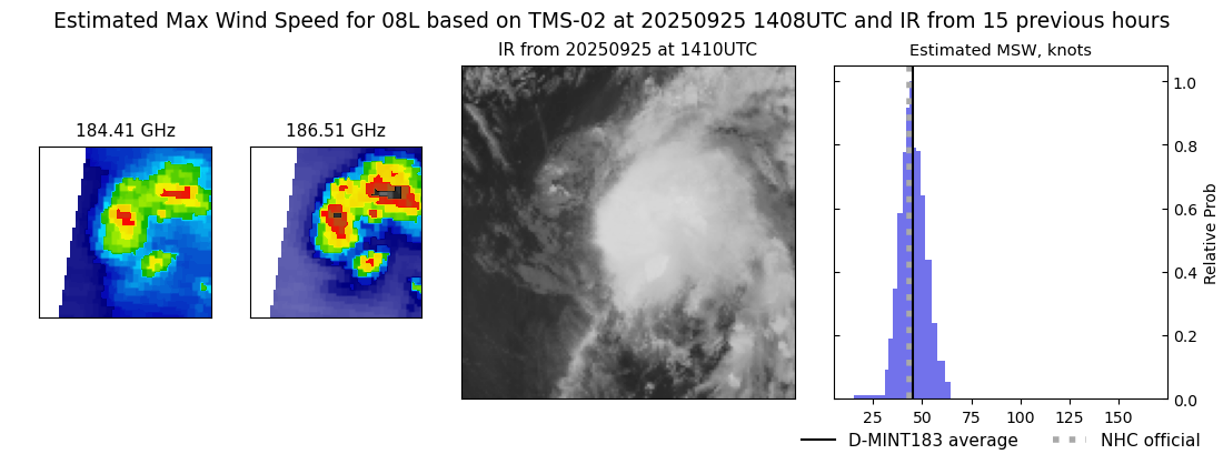 |
| 20250925 | 1142 UTC | GMI | 1006 hPa | 39 kts | 35 kts | 42 kts |  |
| 20250925 | 1138 UTC | GMI | 1006 hPa | 39 kts | 35 kts | 43 kts | 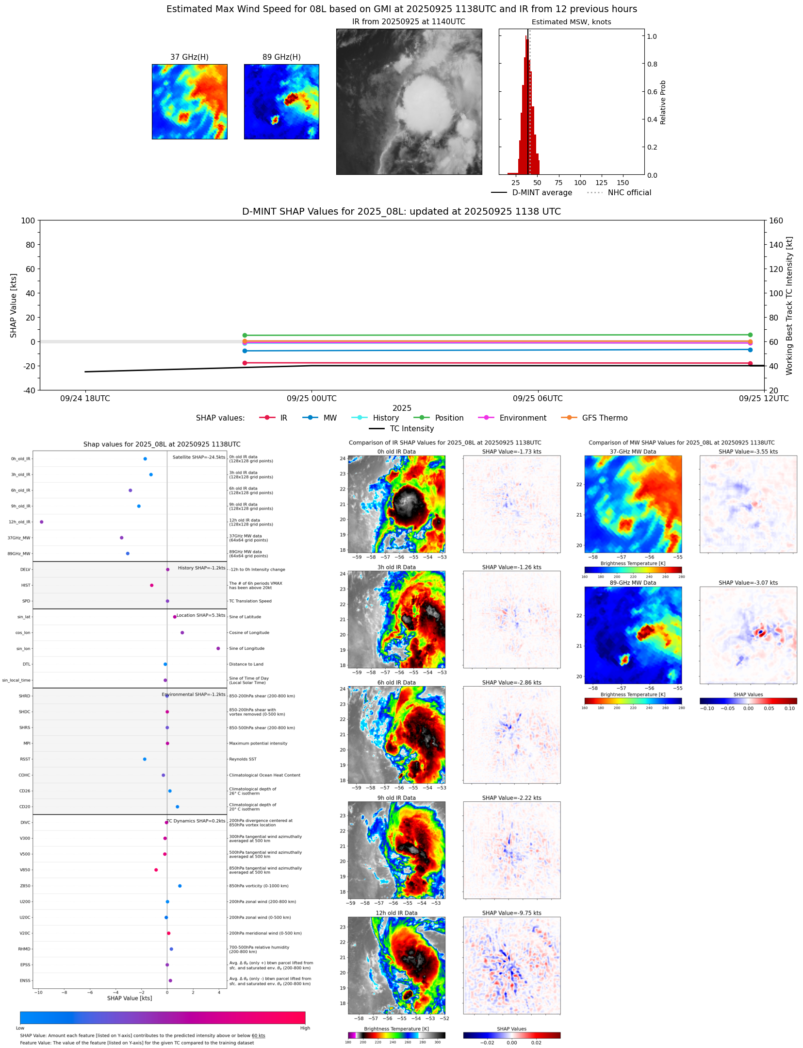 |
| 20250925 | 1038 UTC | TROPICS03 | 1003 hPa | 47 kts | 43 kts | 52 kts |  |
| 20250925 | 0551 UTC | TROPICS05 | 1008 hPa | 37 kts | 34 kts | 41 kts | 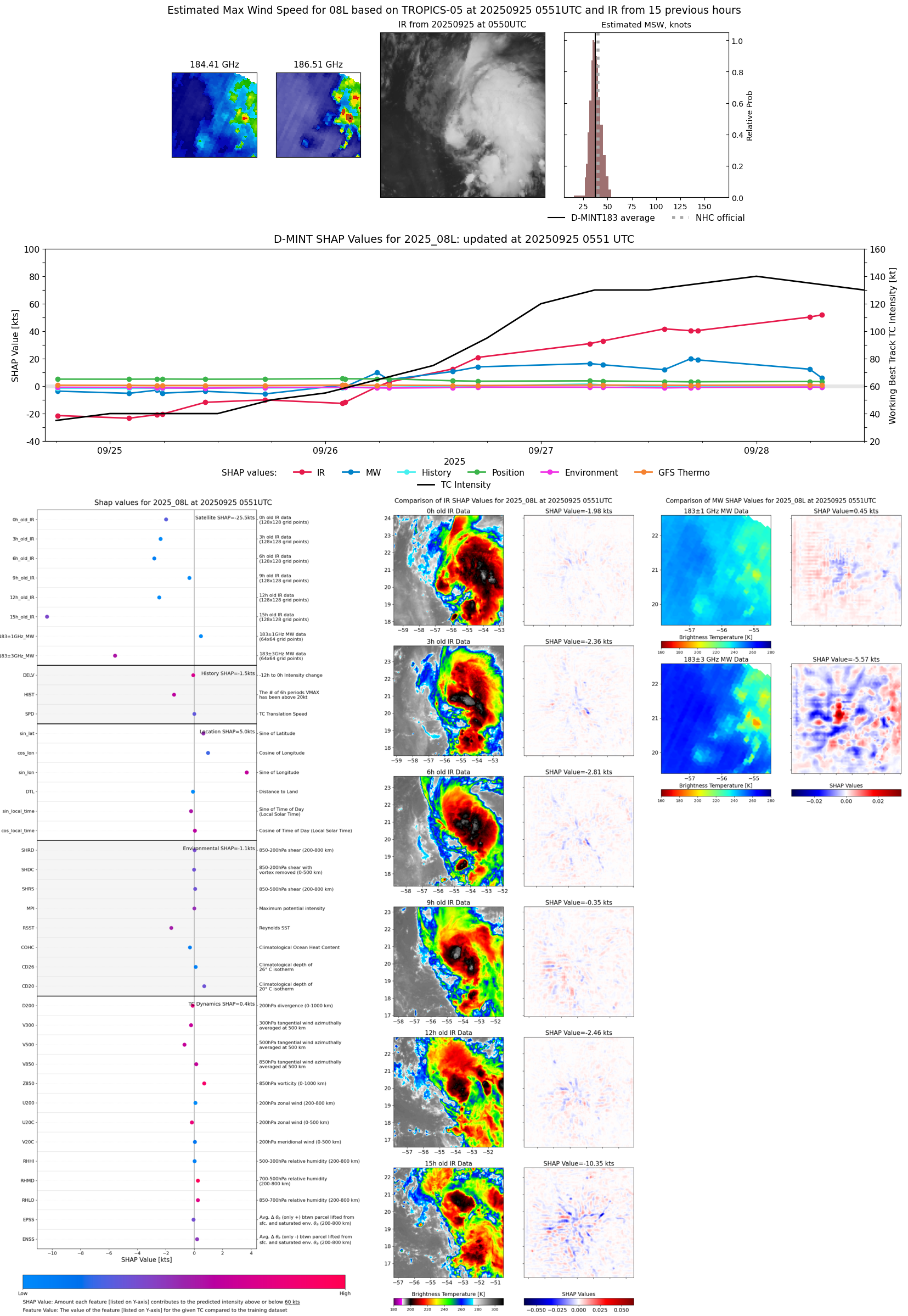 |
| 20250925 | 0514 UTC | ATMS-N20 | 1009 hPa | 39 kts | 35 kts | 44 kts | 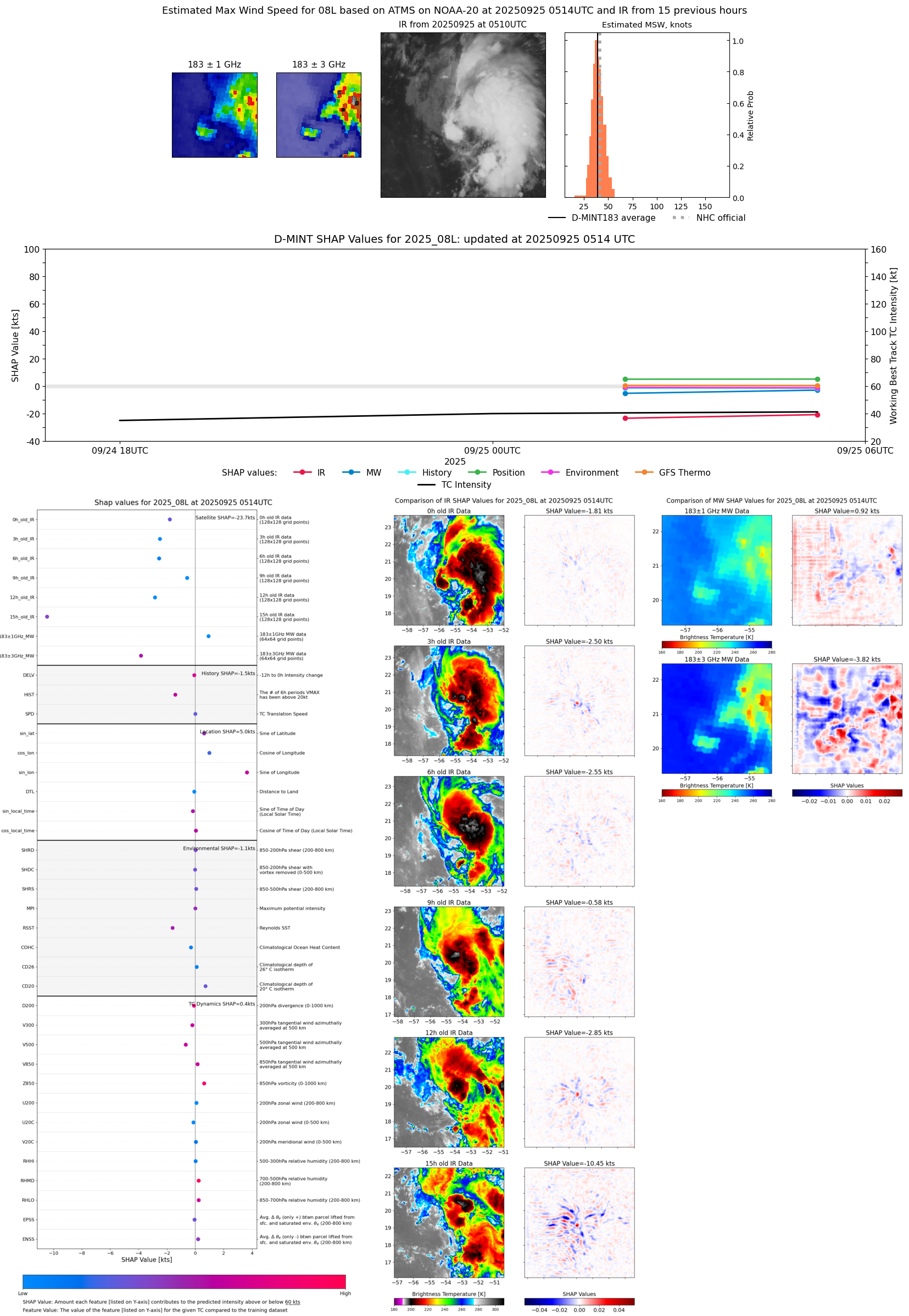 |
| 20250925 | 0208 UTC | TMS05 | 1008 hPa | 34 kts | 31 kts | 38 kts | 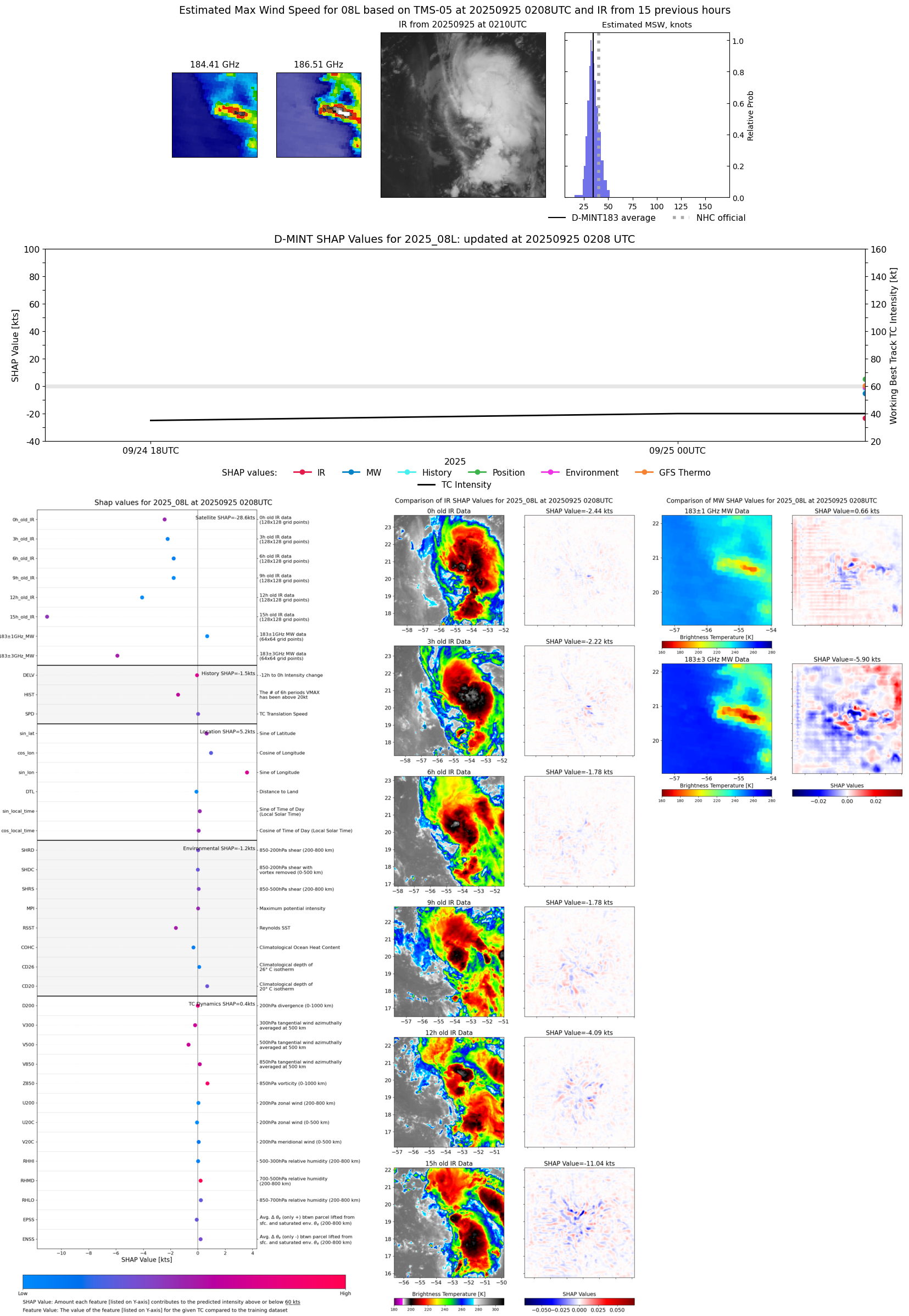 |
| 20250924 | 1002 UTC | SSMISF16 | NaN hPa | 32 kts | 29 kts | 36 kts |  |
| 20250924 | 0917 UTC | SSMISF17 | NaN hPa | 35 kts | 31 kts | 40 kts | 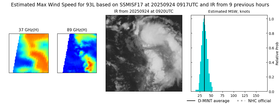 |
| 20250924 | 0759 UTC | SSMISF18 | NaN hPa | 35 kts | 31 kts | 40 kts |  |
| 20250924 | 2213 UTC | GMI | 1007 hPa | 37 kts | 34 kts | 42 kts |  |
| 20250924 | 1811 UTC | TROPICS03 | 1007 hPa | 38 kts | 35 kts | 42 kts |  |
| 20250923 | 2128 UTC | SSMISF16 | NaN hPa | 31 kts | 28 kts | 35 kts |  |
| 20250923 | 2043 UTC | SSMISF17 | NaN hPa | 35 kts | 31 kts | 39 kts | 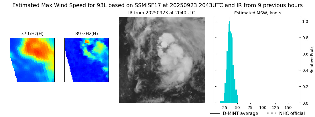 |
| 20250923 | 1131 UTC | GMI | NaN hPa | 25 kts | 22 kts | 27 kts | 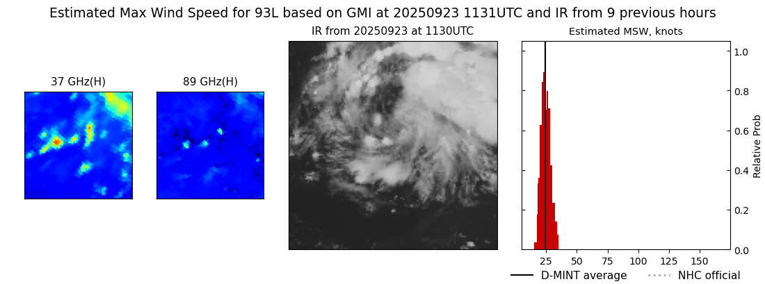 |
| 20250923 | 1016 UTC | SSMISF16 | NaN hPa | 26 kts | 23 kts | 29 kts | 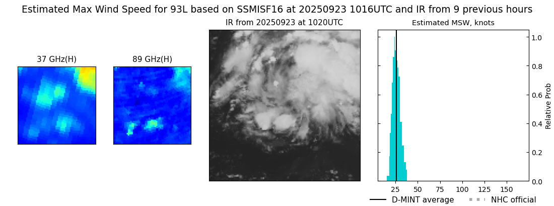 |