|
||

 |
D-MINT HISTORY FILE for 2025_09L
| Date | Time | MW Sensor | MSLP | Vmax (30th-70th percentile average) | Vmax 25th percentile | Vmax 75th percentile | Image |
| 20251002 | 1943 UTC | GMI | 986 hPa | 47 kts | 42 kts | 52 kts | 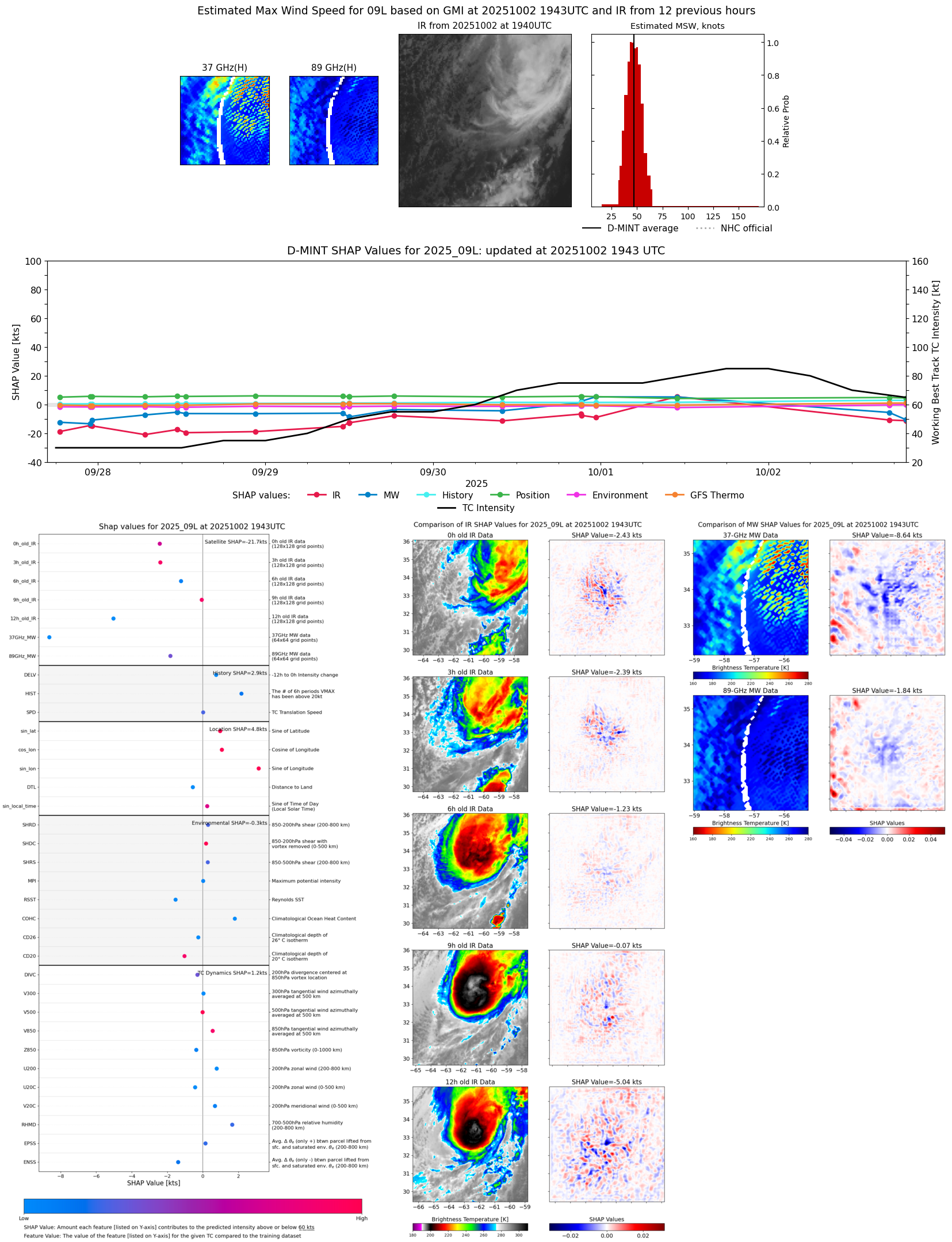 |
| 20251002 | 1718 UTC | AMSR2 | 984 hPa | 53 kts | 47 kts | 58 kts |  |
| 20251002 | 1431 UTC | AWS | 976 hPa | 62 kts | 57 kts | 67 kts |  |
| 20251002 | 1351 UTC | TMS05 | 978 hPa | 60 kts | 54 kts | 65 kts | 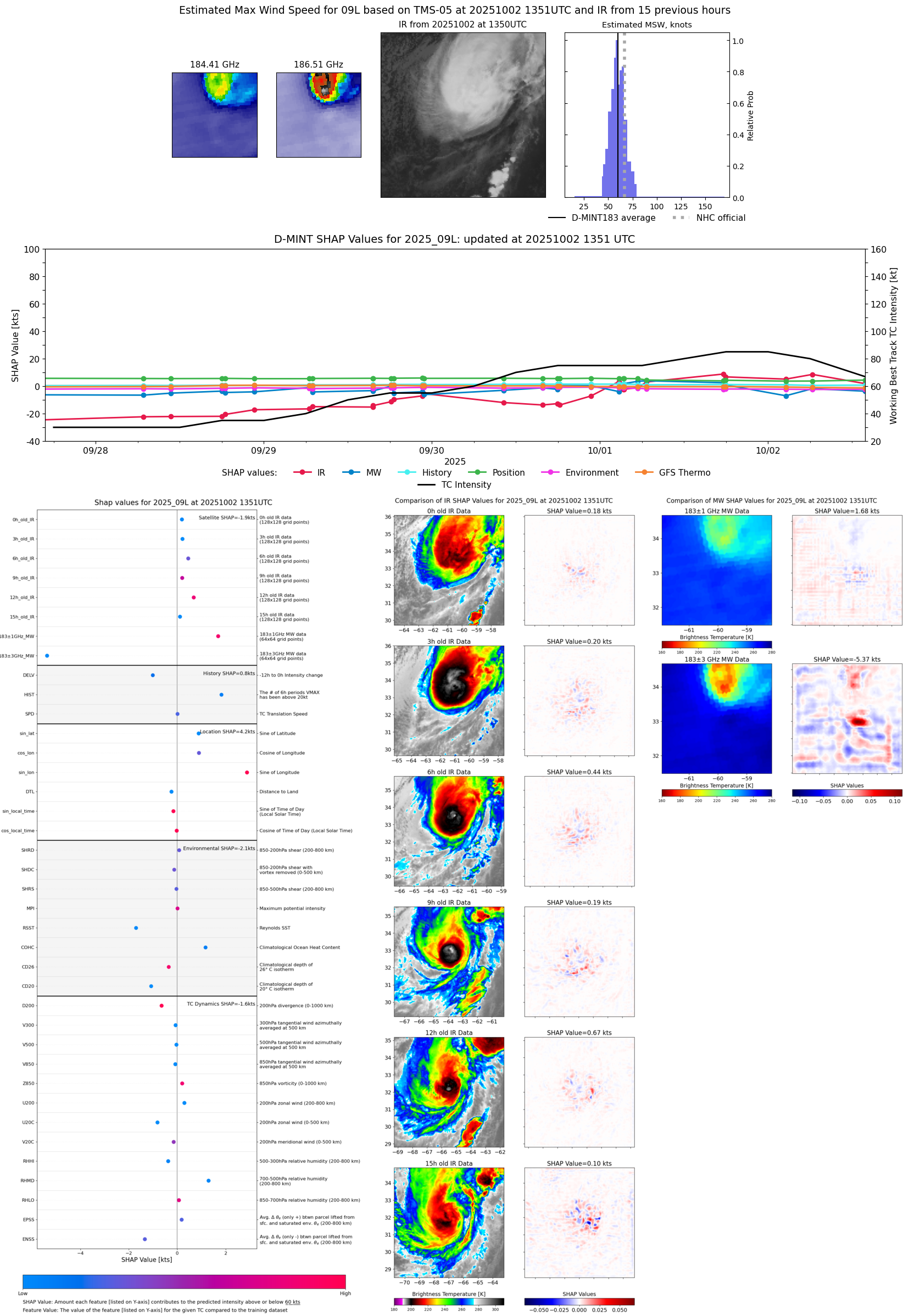 |
| 20251002 | 0620 UTC | ATMS-N20 | 970 hPa | 68 kts | 63 kts | 73 kts |  |
| 20251002 | 0617 UTC | AMSR2 | 973 hPa | 66 kts | 60 kts | 73 kts | 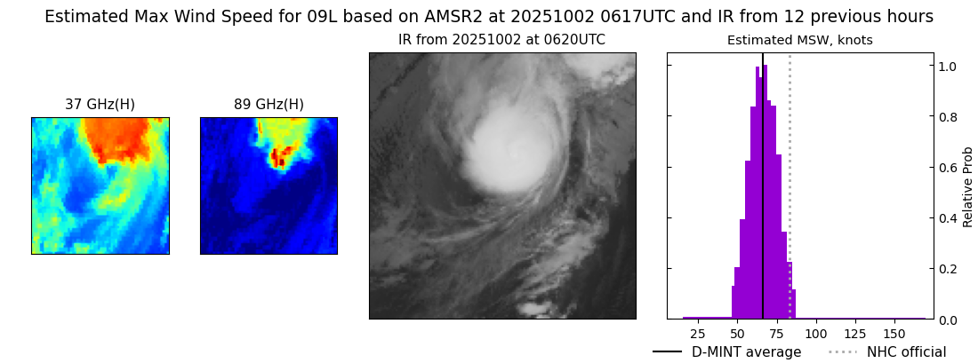 |
| 20251002 | 0232 UTC | TMS06 | 971 hPa | 60 kts | 56 kts | 64 kts | 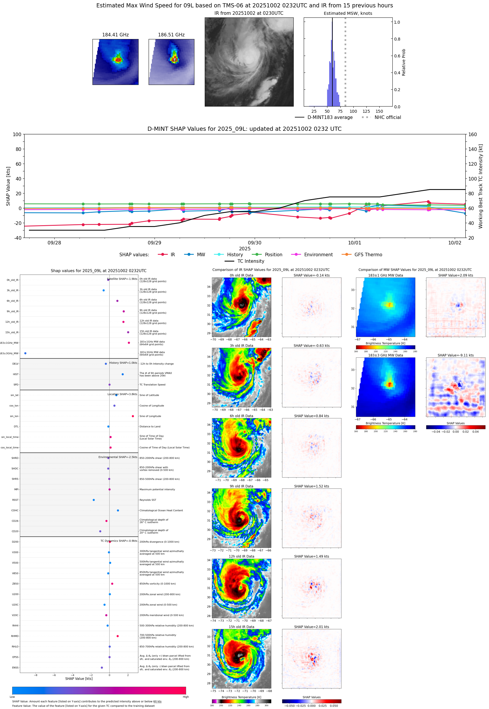 |
| 20251001 | 1813 UTC | AMSR2 | 972 hPa | 82 kts | 76 kts | 89 kts | 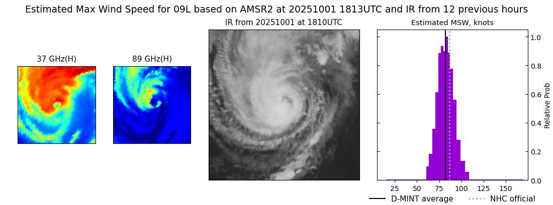 |
| 20251001 | 1757 UTC | ATMS-N20 | 971 hPa | 71 kts | 66 kts | 76 kts |  |
| 20251001 | 1736 UTC | ATMS-NPP | 972 hPa | 74 kts | 69 kts | 79 kts |  |
| 20251001 | 1144 UTC | SSMISF16 | 975 hPa | 74 kts | 69 kts | 80 kts |  |
| 20251001 | 1055 UTC | SSMISF17 | 977 hPa | 71 kts | 66 kts | 77 kts |  |
| 20251001 | 0640 UTC | ATMS-N20 | 981 hPa | 70 kts | 66 kts | 75 kts | 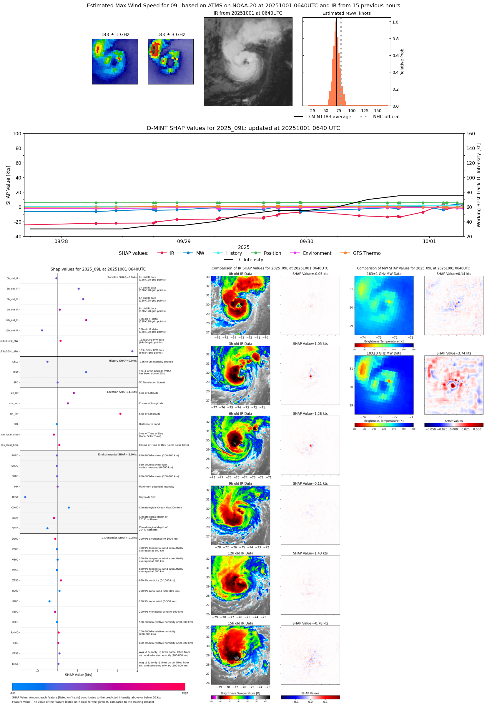 |
| 20251001 | 0524 UTC | TMS07 | 978 hPa | 68 kts | 62 kts | 73 kts |  |
| 20251001 | 0325 UTC | TMS05 | 981 hPa | 65 kts | 60 kts | 71 kts | 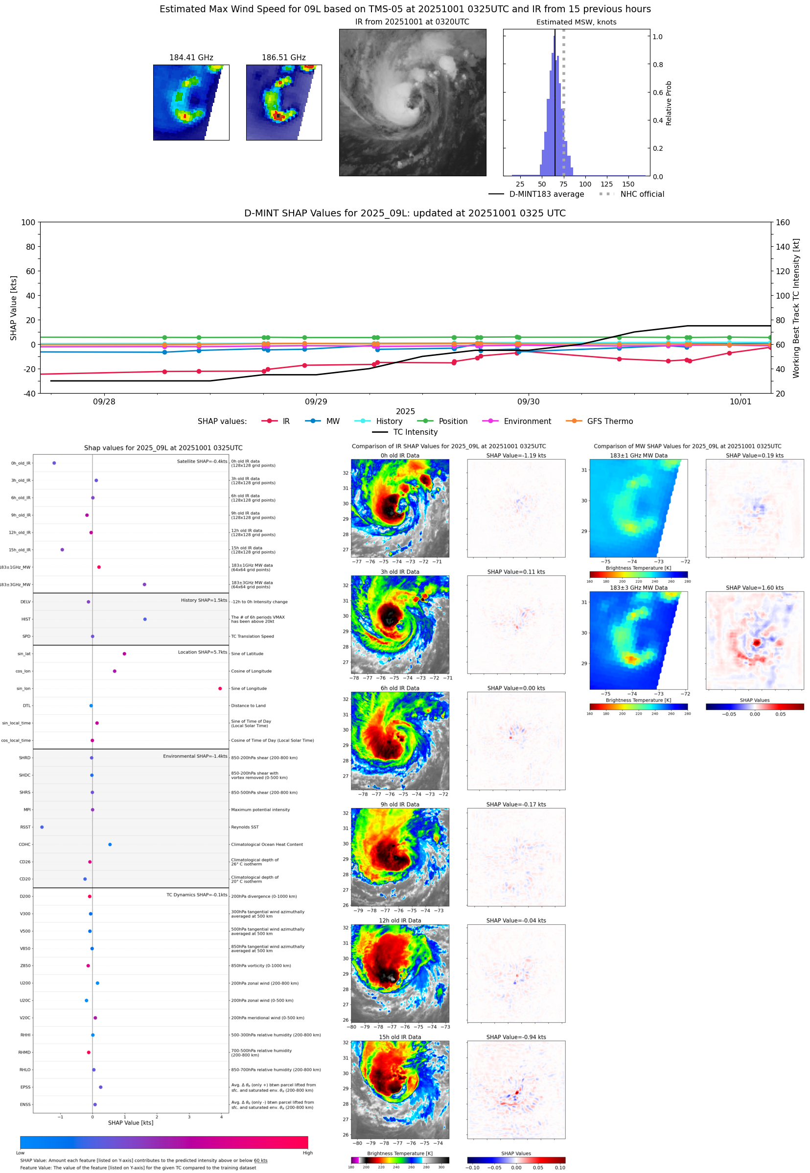 |
| 20251001 | 0321 UTC | TMS02 | 981 hPa | 64 kts | 59 kts | 69 kts | 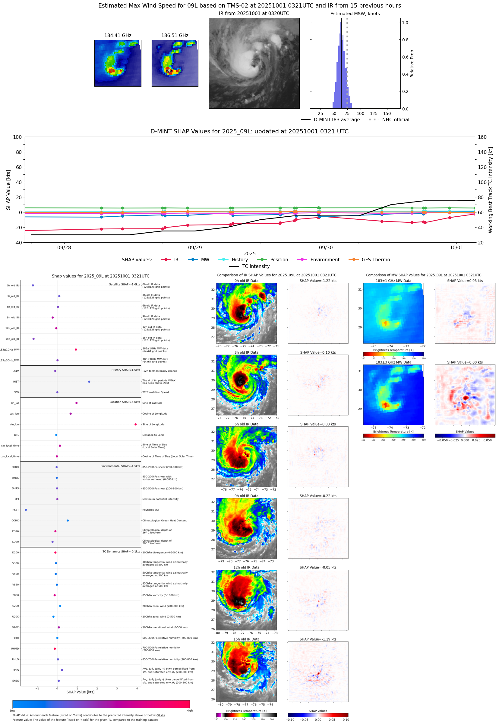 |
| 20251001 | 0242 UTC | TROPICS05 | 982 hPa | 65 kts | 60 kts | 70 kts |  |
| 20250930 | 2318 UTC | SSMISF16 | 984 hPa | 62 kts | 57 kts | 68 kts | 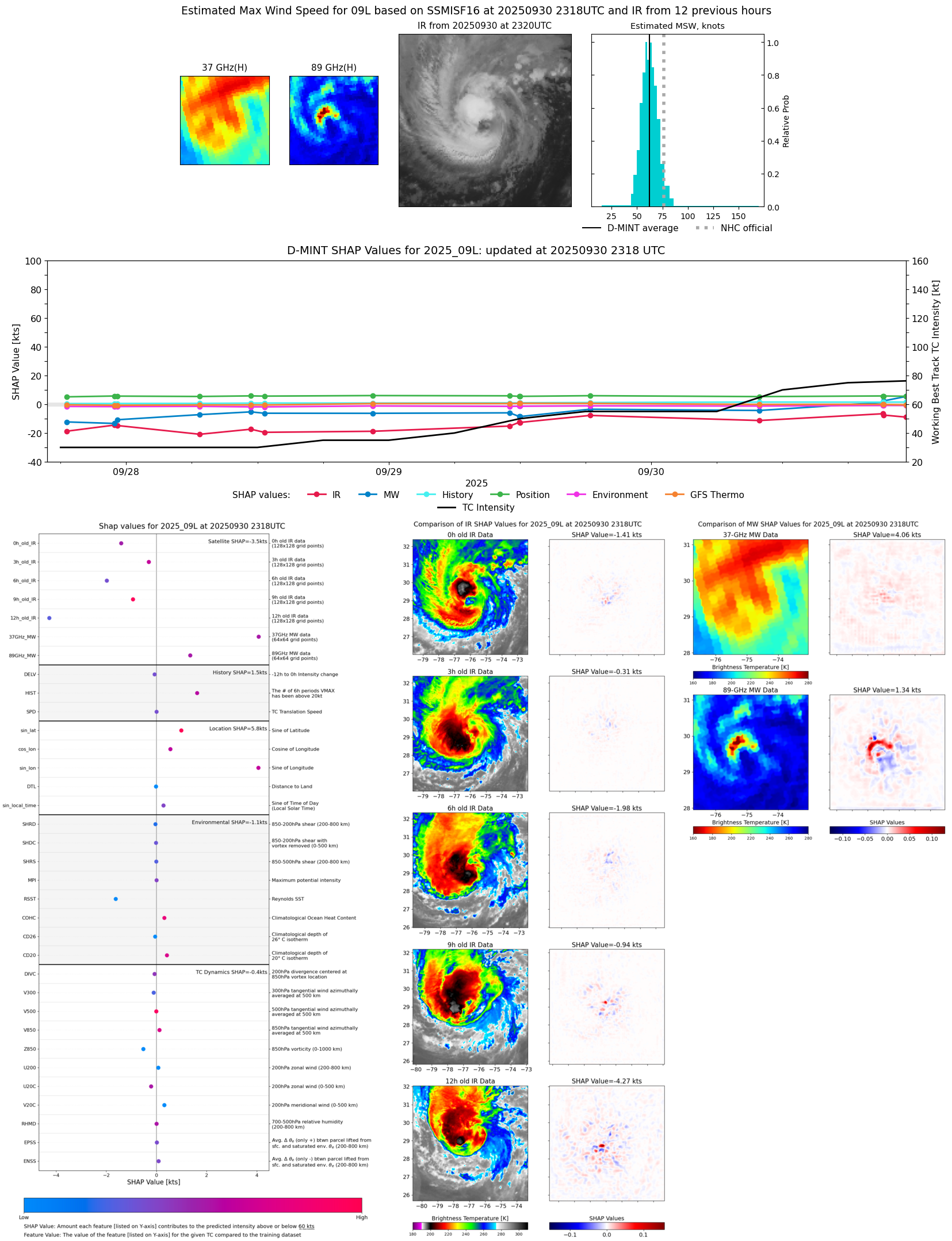 |
| 20250930 | 2242 UTC | TMS07 | 984 hPa | 60 kts | 55 kts | 65 kts | 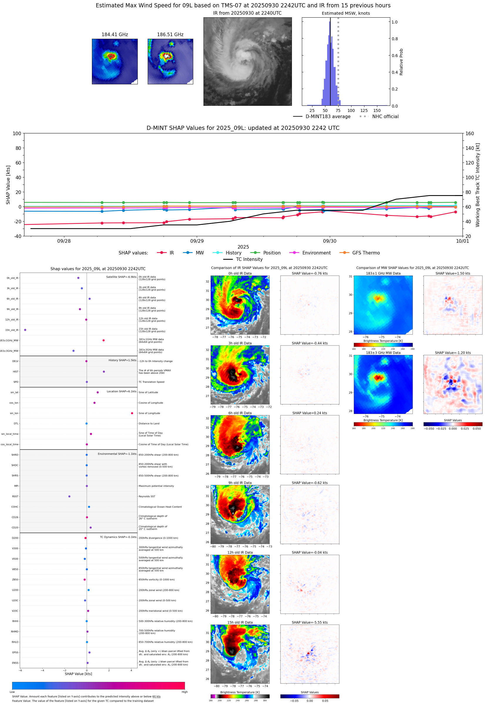 |
| 20250930 | 2114 UTC | SSMISF18 | 986 hPa | 61 kts | 56 kts | 67 kts |  |
| 20250930 | 2113 UTC | SSMISF18 | 988 hPa | 61 kts | 56 kts | 67 kts |  |
| 20250930 | 1815 UTC | ATMS-N20 | 985 hPa | 53 kts | 49 kts | 58 kts | 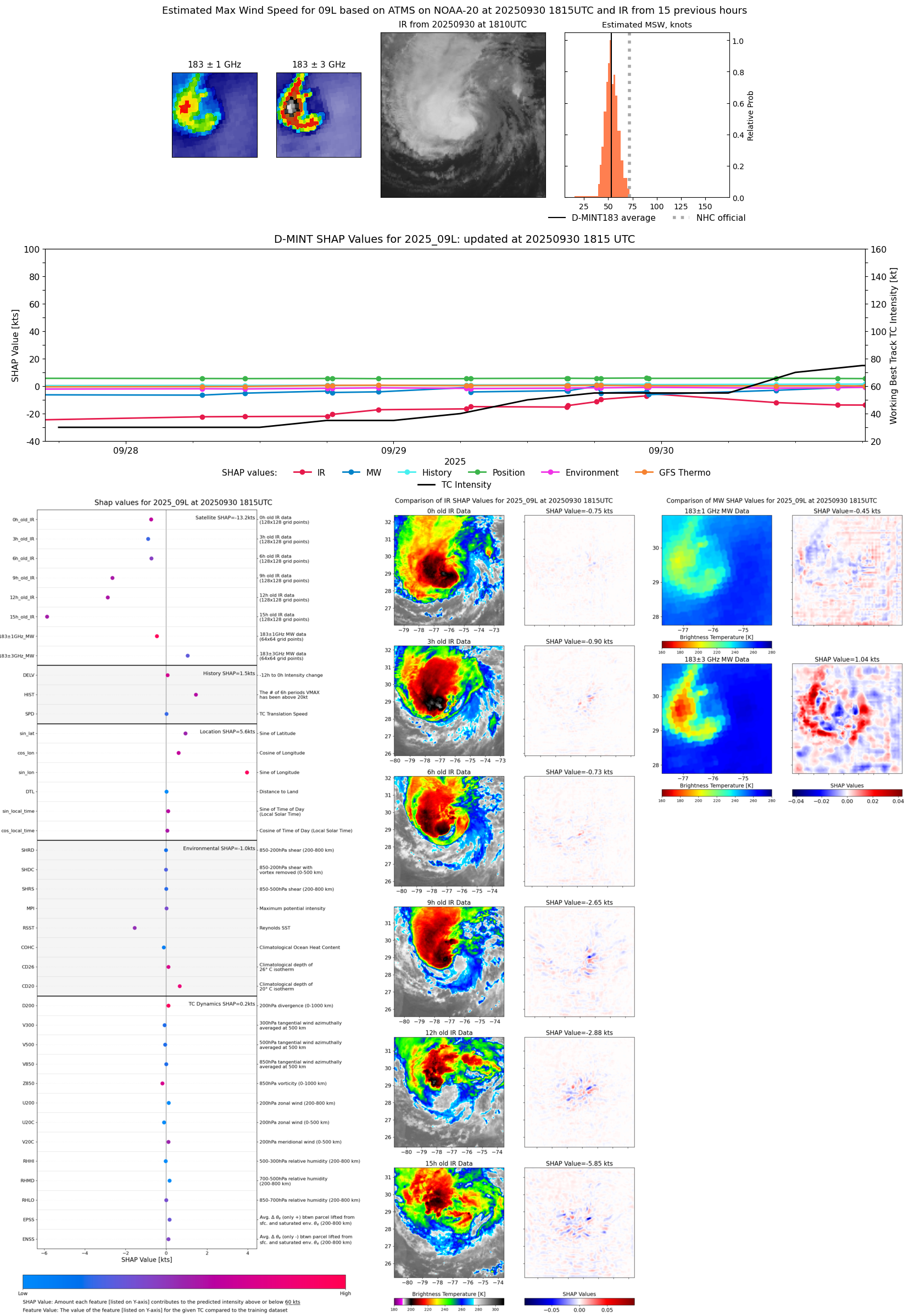 |
| 20250930 | 1755 UTC | ATMS-NPP | 988 hPa | 51 kts | 47 kts | 56 kts |  |
| 20250930 | 1547 UTC | AWS | 989 hPa | 52 kts | 47 kts | 56 kts | 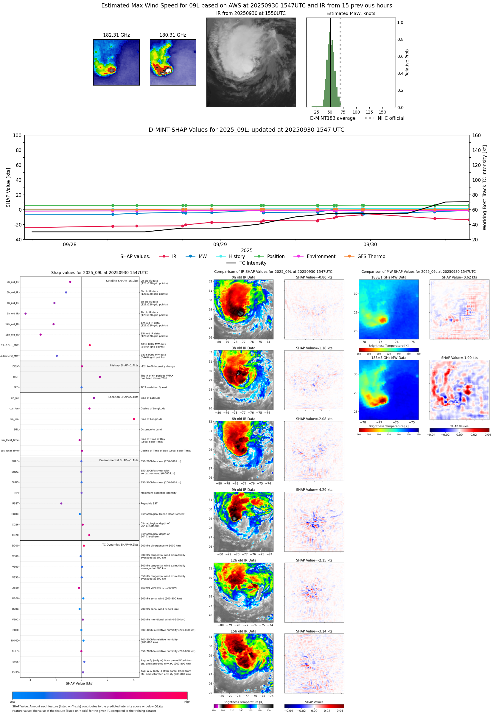 |
| 20250930 | 1016 UTC | TROPICS03 | 989 hPa | 51 kts | 46 kts | 57 kts | 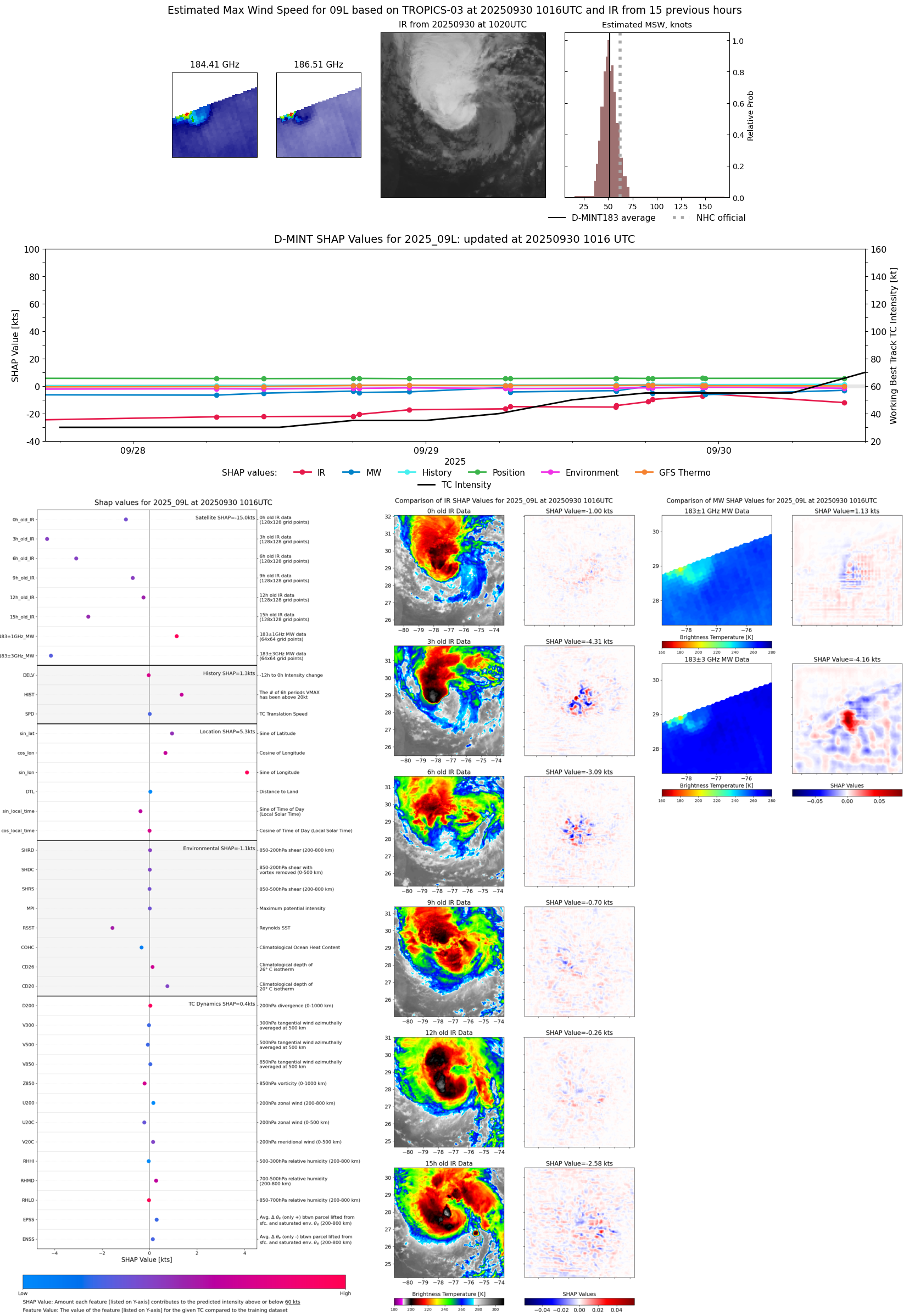 |
| 20250930 | 0954 UTC | SSMISF18 | 992 hPa | 50 kts | 45 kts | 55 kts |  |
| 20250930 | 0659 UTC | ATMS-N20 | 988 hPa | 54 kts | 49 kts | 60 kts | 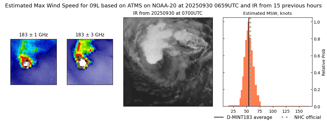 |
| 20250930 | 0631 UTC | AMSR2 | 995 hPa | 60 kts | 55 kts | 65 kts | 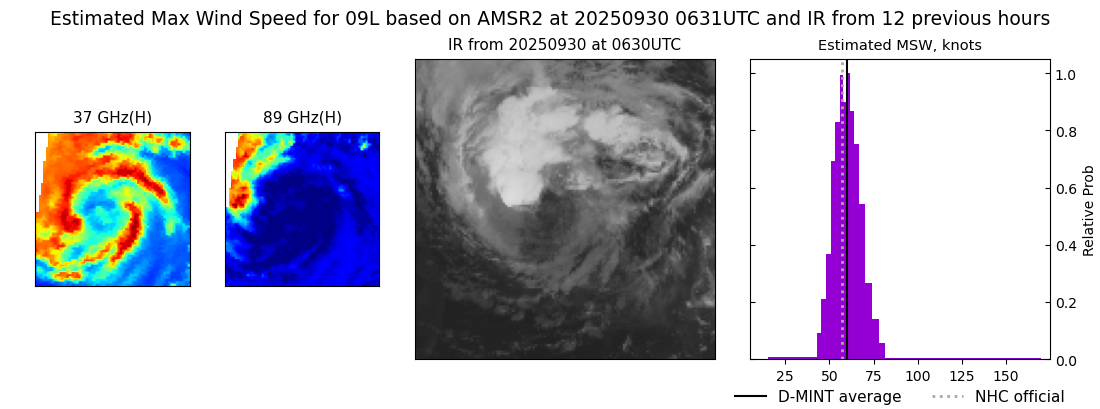 |
| 20250929 | 2253 UTC | TROPICS05 | 991 hPa | 55 kts | 50 kts | 61 kts | 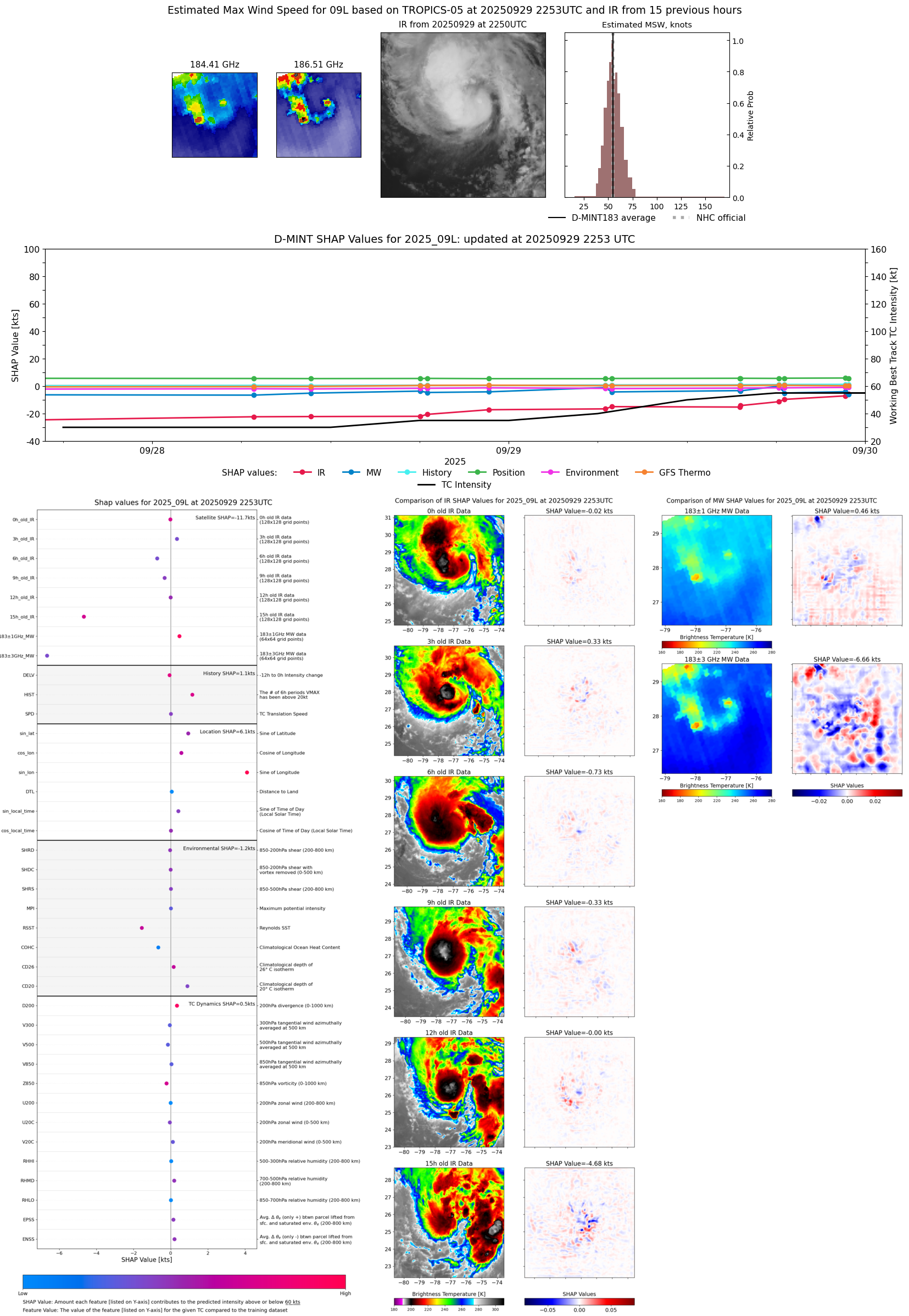 |
| 20250929 | 2240 UTC | TMS07 | 991 hPa | 56 kts | 50 kts | 62 kts | 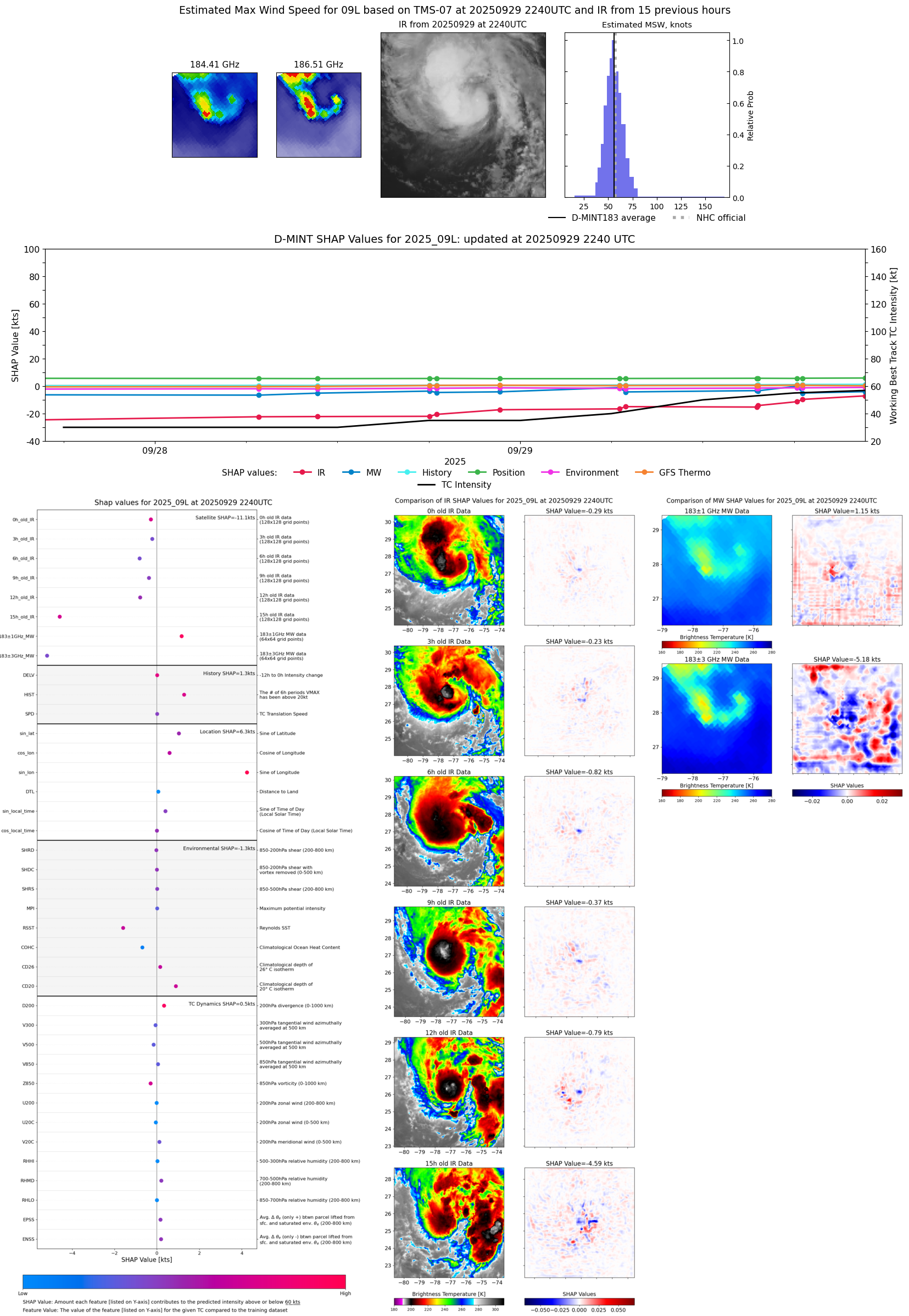 |
| 20250929 | 2219 UTC | WSFM01 | 992 hPa | 63 kts | 57 kts | 70 kts | 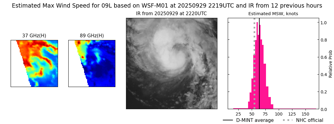 |
| 20250929 | 2219 UTC | WSFM01 | 992 hPa | 63 kts | 57 kts | 70 kts |  |
| 20250929 | 1834 UTC | ATMS-N20 | 992 hPa | 52 kts | 47 kts | 57 kts |  |
| 20250929 | 1824 UTC | AMSR2 | 994 hPa | 55 kts | 50 kts | 61 kts |  |
| 20250929 | 1812 UTC | ATMS-NPP | 991 hPa | 55 kts | 51 kts | 60 kts | 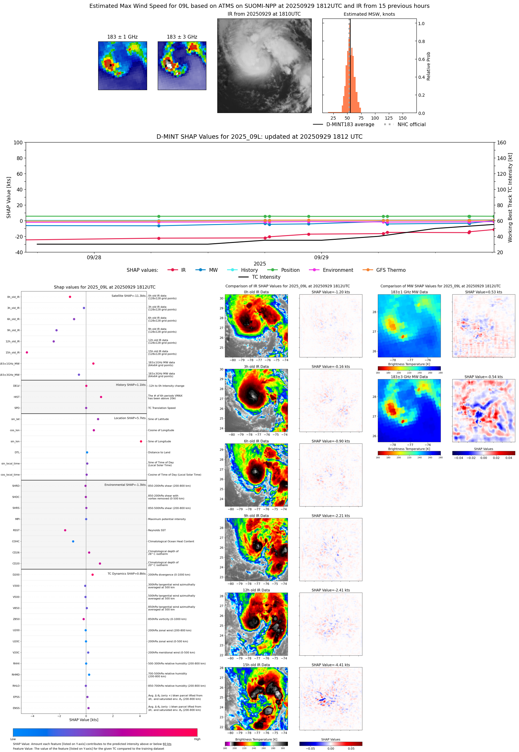 |
| 20250929 | 1537 UTC | AWS | 997 hPa | 49 kts | 44 kts | 54 kts |  |
| 20250929 | 1533 UTC | TMS02 | 1000 hPa | 48 kts | 43 kts | 53 kts | 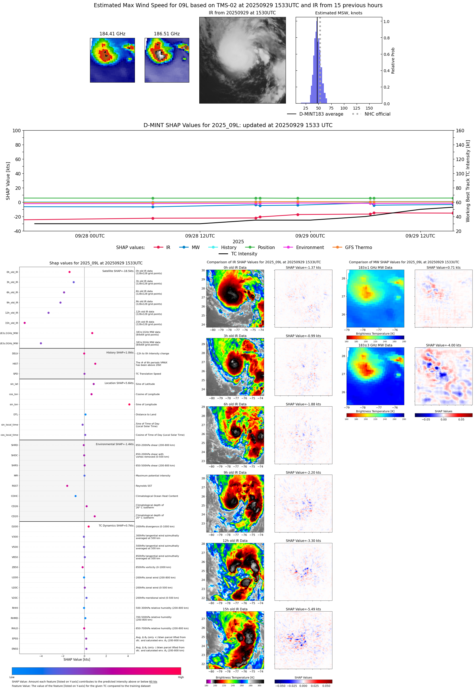 |
| 20250929 | 1202 UTC | GMI | 1002 hPa | 45 kts | 41 kts | 49 kts | 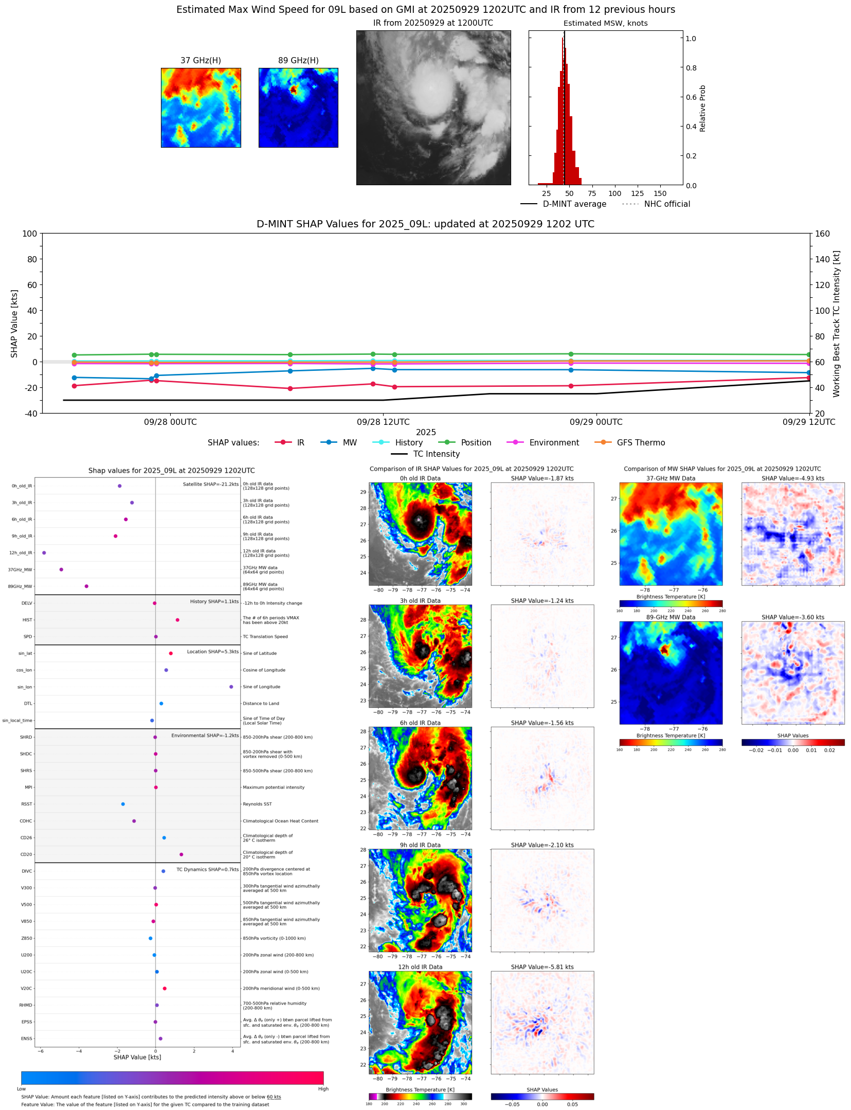 |
| 20250929 | 1158 UTC | GMI | 1001 hPa | 45 kts | 41 kts | 49 kts |  |
| 20250929 | 1104 UTC | WSFM01 | 1003 hPa | 45 kts | 41 kts | 49 kts |  |
| 20250929 | 0656 UTC | TMS07 | 999 hPa | 46 kts | 42 kts | 51 kts | 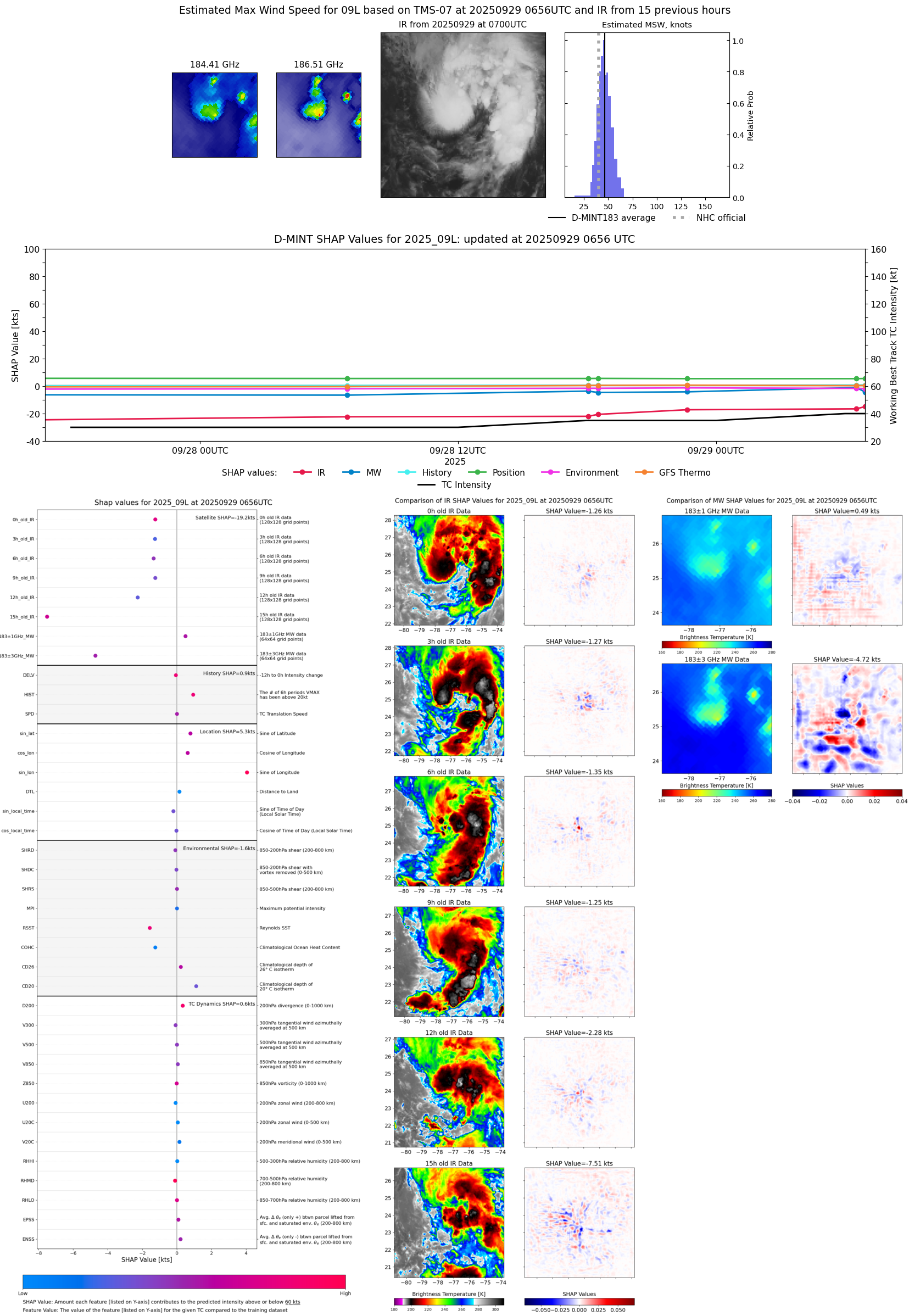 |
| 20250929 | 0631 UTC | ATMS-N21 | 994 hPa | 48 kts | 43 kts | 53 kts | 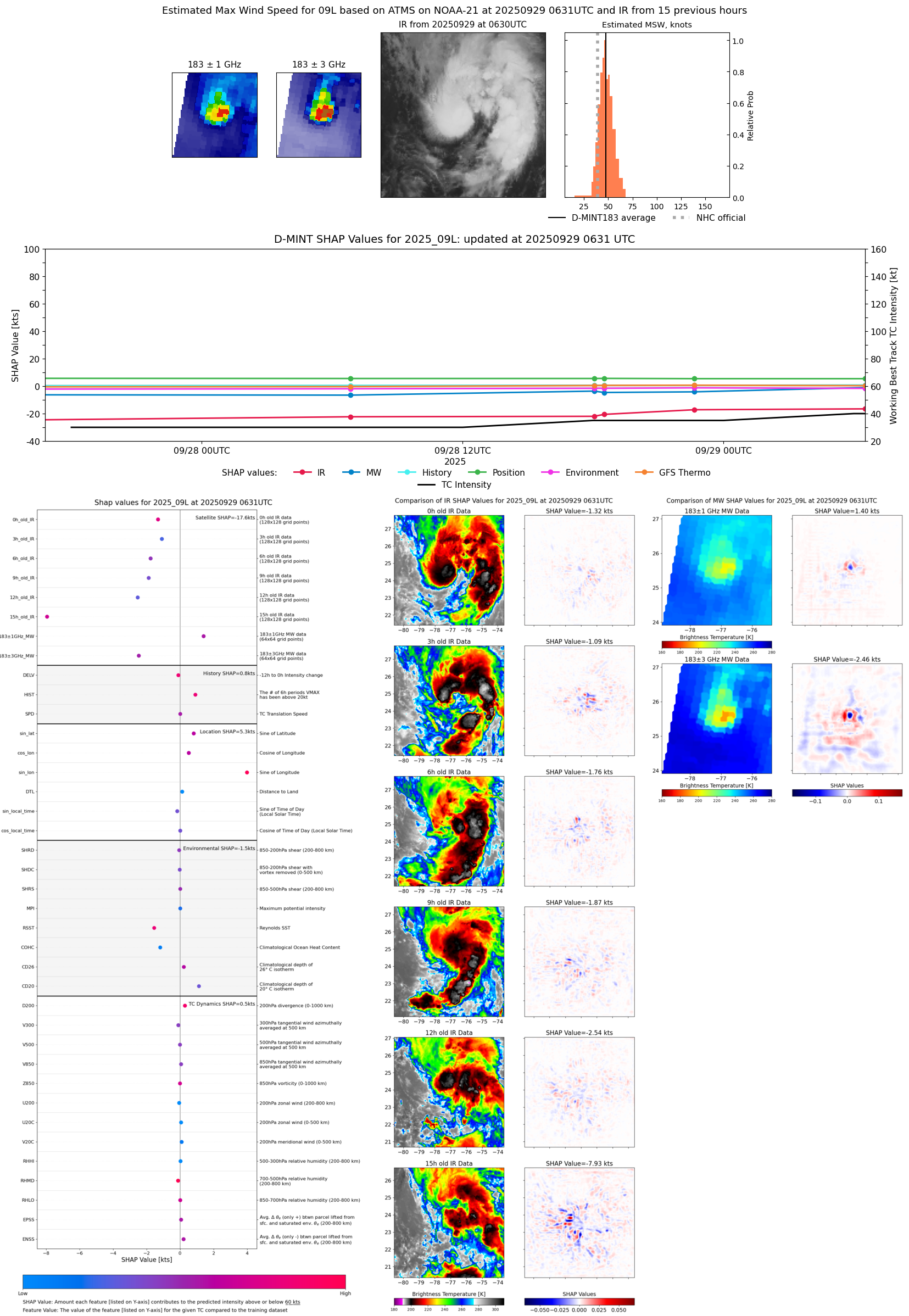 |
| 20250928 | 2239 UTC | TMS07 | 1002 hPa | 44 kts | 40 kts | 49 kts | 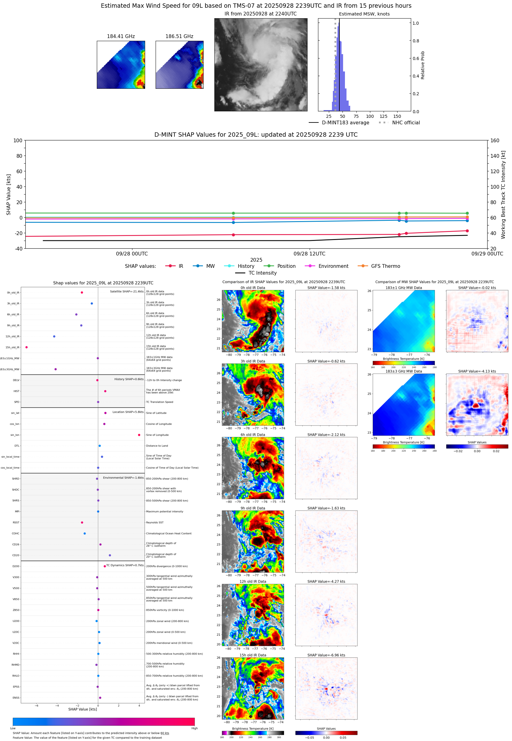 |
| 20250928 | 2237 UTC | WSFM01 | 1002 hPa | 41 kts | 37 kts | 46 kts |  |
| 20250928 | 2233 UTC | GMI | 1003 hPa | 41 kts | 37 kts | 46 kts | 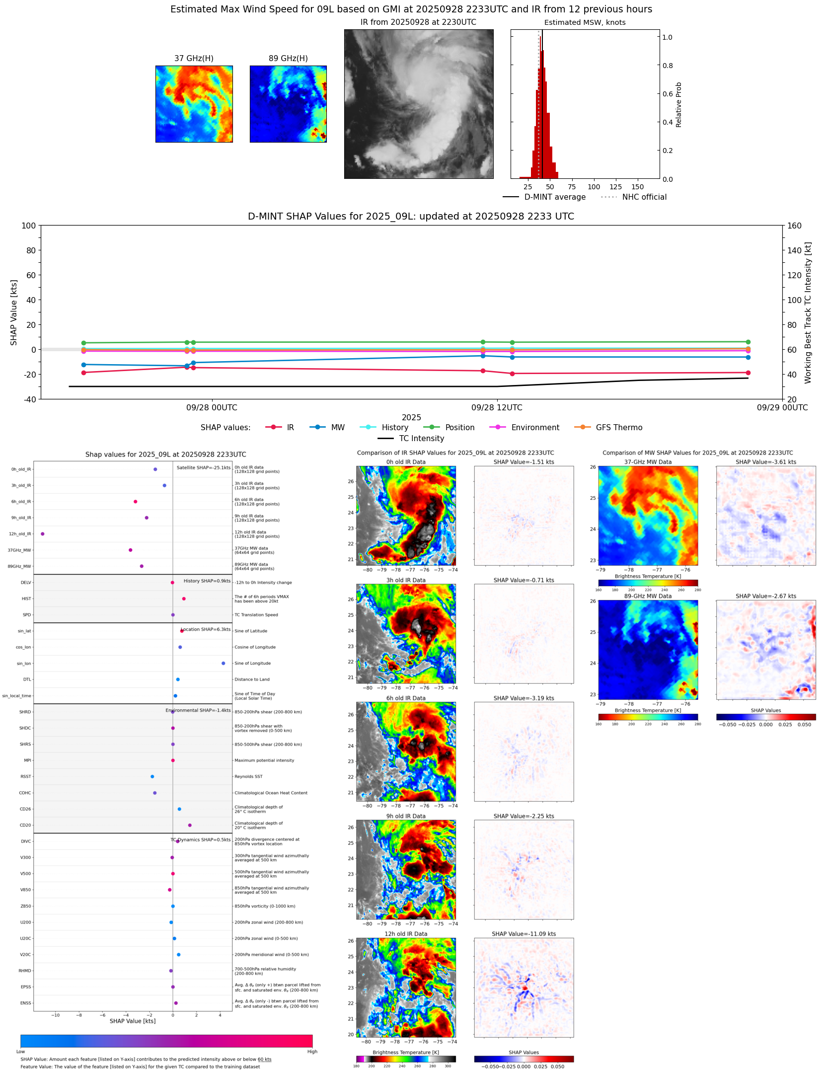 |
| 20250928 | 1831 UTC | ATMS-NPP | 1002 hPa | 40 kts | 36 kts | 45 kts | 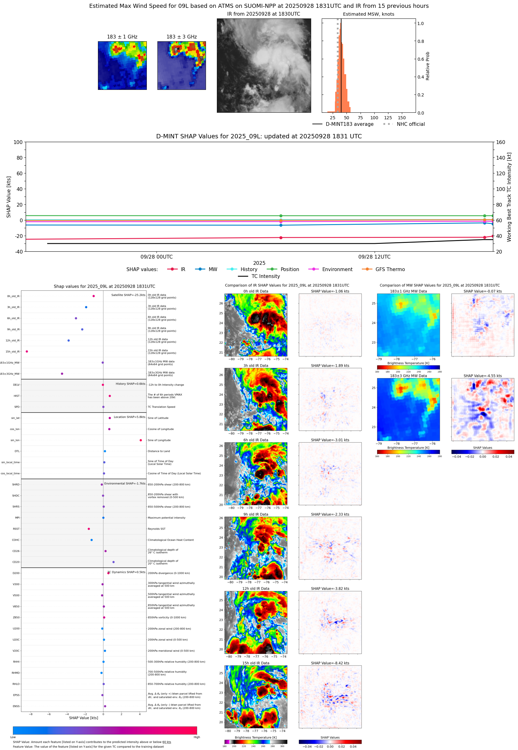 |
| 20250928 | 1803 UTC | ATMS-N21 | 1002 hPa | 40 kts | 36 kts | 44 kts |  |
| 20250928 | 1238 UTC | GMI | 1004 hPa | 39 kts | 34 kts | 43 kts |  |
| 20250928 | 1124 UTC | WSFM01 | 1003 hPa | 42 kts | 37 kts | 46 kts |  |
| 20250928 | 1042 UTC | TROPICS03 | 1003 hPa | 36 kts | 33 kts | 41 kts |  |
| 20250928 | 0650 UTC | ATMS-N21 | 1003 hPa | 35 kts | 32 kts | 39 kts | 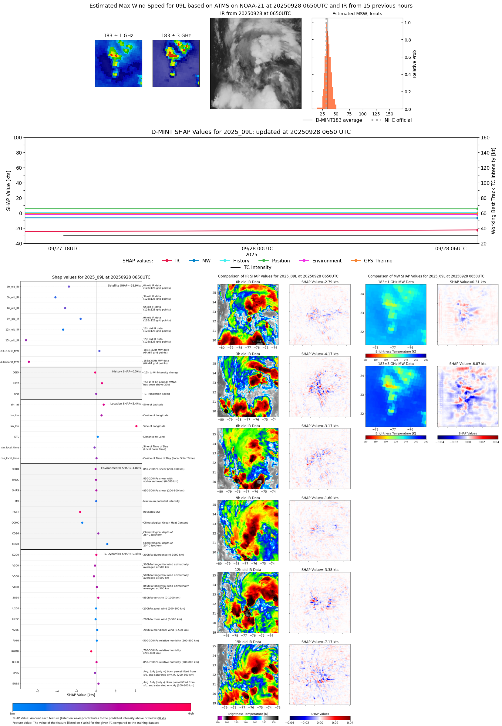 |
| 20250928 | 0644 UTC | AMSR2 | 1005 hPa | 36 kts | 32 kts | 40 kts |  |
| 20250927 | 2313 UTC | GMI | 1005 hPa | 38 kts | 34 kts | 43 kts |  |
| 20250927 | 2256 UTC | WSFM01 | 1005 hPa | 36 kts | 32 kts | 40 kts | 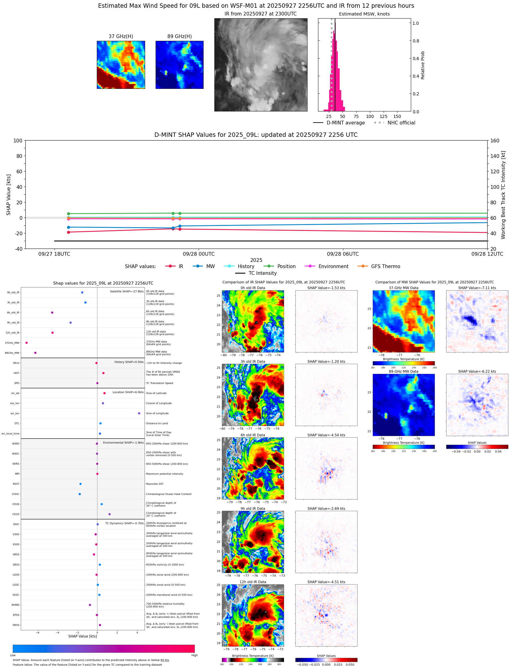 |
| 20250927 | 1835 UTC | AMSR2 | 1007 hPa | 33 kts | 29 kts | 37 kts | 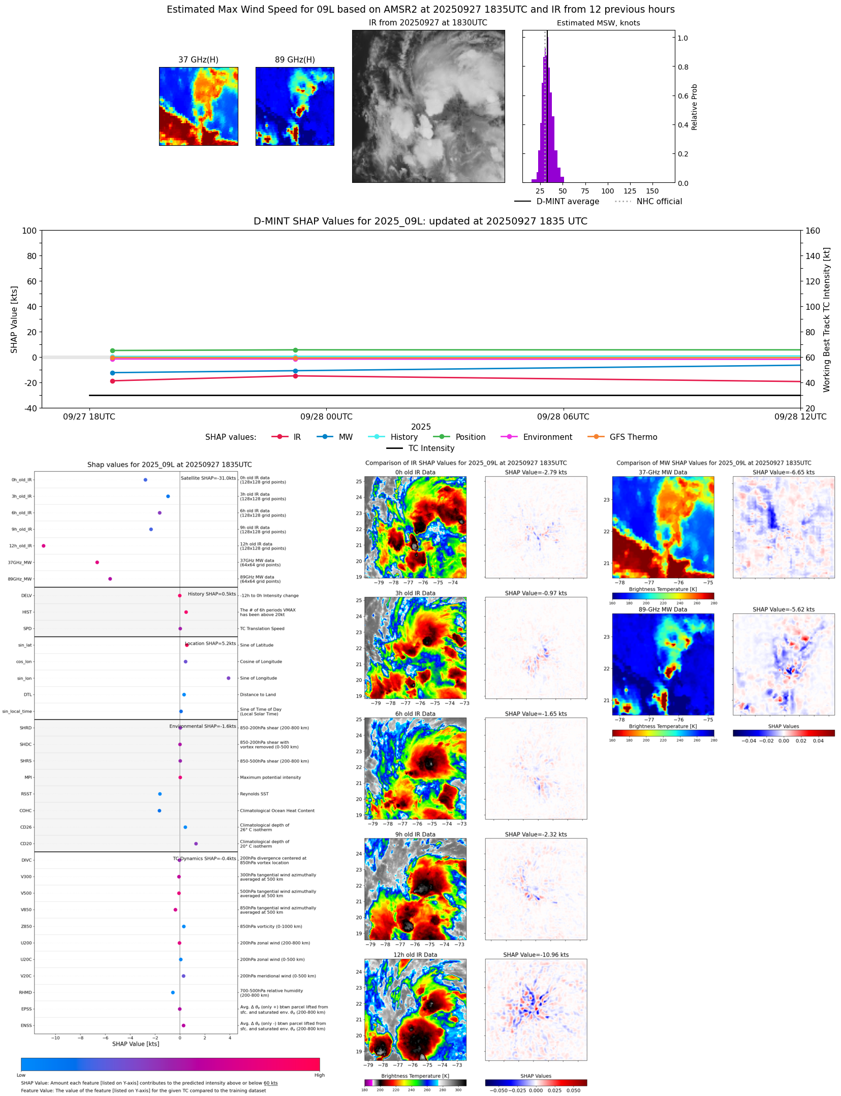 |
| 20250927 | 1522 UTC | TMS05 | NaN hPa | 32 kts | 29 kts | 36 kts | 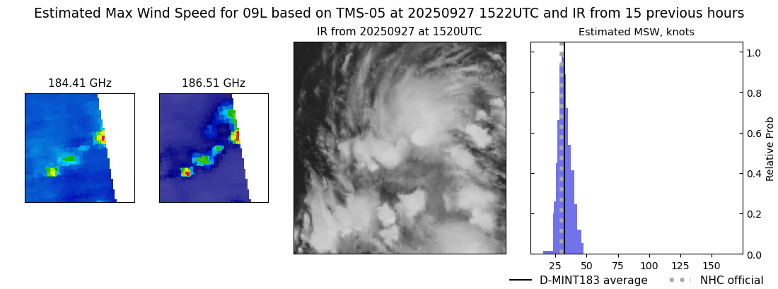 |
| 20250926 | 1233 UTC | GMI | NaN hPa | 28 kts | 24 kts | 32 kts | 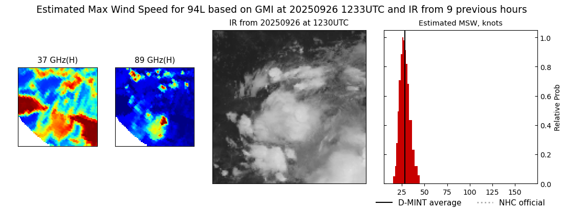 |
| 20250926 | 0658 UTC | AMSR2 | NaN hPa | 29 kts | 25 kts | 33 kts |  |
| 20250925 | 2309 UTC | GMI | NaN hPa | 25 kts | 23 kts | 29 kts | 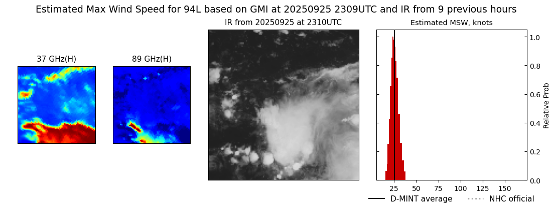 |
| 20250925 | 0614 UTC | AMSR2 | NaN hPa | 27 kts | 24 kts | 31 kts | 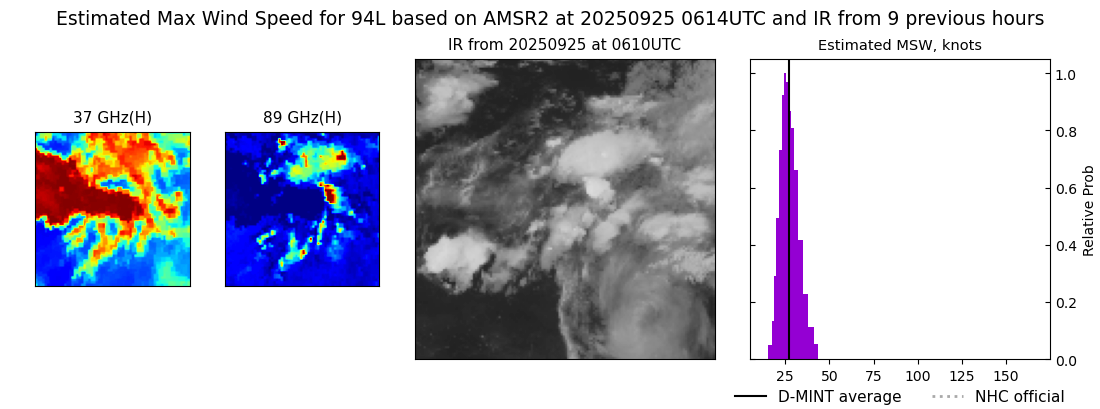 |
| 20250924 | 1803 UTC | AMSR2 | NaN hPa | 26 kts | 23 kts | 29 kts | 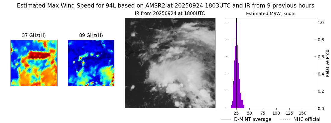 |
| 20250924 | 0801 UTC | SSMISF18 | NaN hPa | 28 kts | 24 kts | 31 kts |  |
| 20250923 | 2310 UTC | SSMISF16 | NaN hPa | 33 kts | 29 kts | 37 kts | 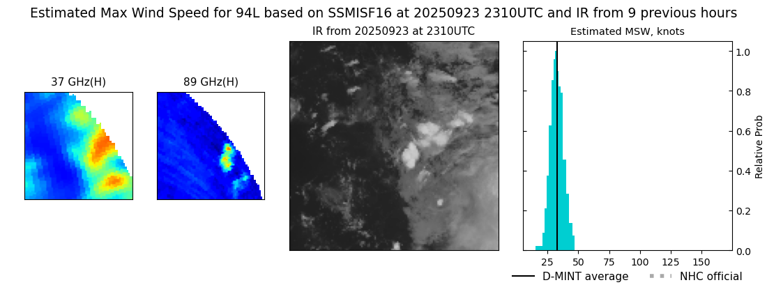 |
| 20250923 | 2310 UTC | SSMISF16 | NaN hPa | 33 kts | 29 kts | 37 kts |  |
| 20250923 | 2224 UTC | SSMISF17 | NaN hPa | 29 kts | 26 kts | 33 kts | 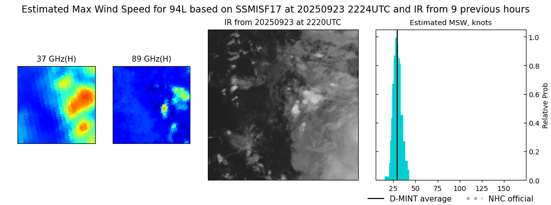 |
| 20250923 | 1719 UTC | AMSR2 | NaN hPa | 22 kts | 20 kts | 24 kts |  |