|
||

 |
D-MINT HISTORY FILE for 2025_10S
| Date | Time | MW Sensor | MSLP | Vmax (30th-70th percentile average) | Vmax 25th percentile | Vmax 75th percentile | Image |
| 20250123 | 1804 UTC | ATMS-N20 | NaN hPa | 24 kts | 23 kts | 26 kts |  |
| 20250123 | 1133 UTC | GMI | 1004 hPa | 19 kts | 18 kts | 20 kts |  |
| 20250123 | 1057 UTC | SSMISF16 | 1003 hPa | 16 kts | 15 kts | 18 kts |  |
| 20250123 | 0647 UTC | ATMS-N20 | 1005 hPa | 21 kts | 19 kts | 23 kts |  |
| 20250123 | 0645 UTC | AMSR2 | 1005 hPa | 19 kts | 18 kts | 20 kts |  |
| 20250122 | 2229 UTC | SSMISF16 | 1002 hPa | 21 kts | 20 kts | 24 kts | 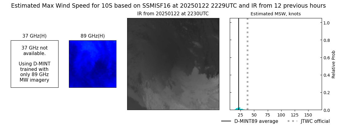 |
| 20250122 | 2208 UTC | GMI | 1002 hPa | 23 kts | 21 kts | 25 kts | 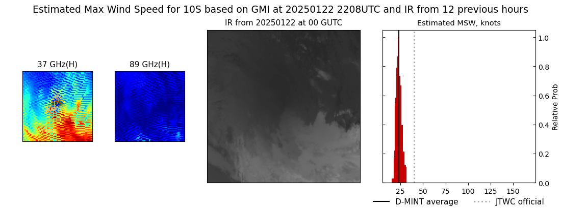 |
| 20250122 | 1952 UTC | SSMISF18 | 1001 hPa | 22 kts | 21 kts | 25 kts |  |
| 20250122 | 1218 UTC | GMI | NaN hPa | 36 kts | 32 kts | 41 kts | 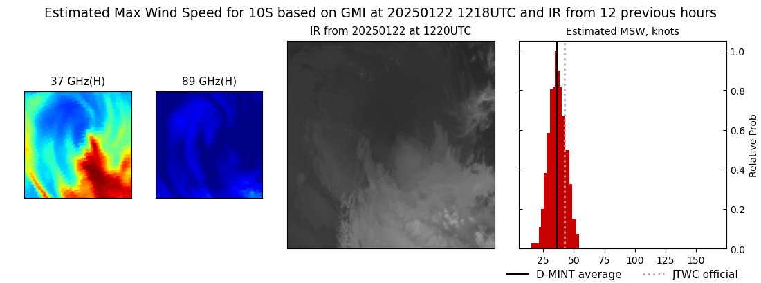 |
| 20250122 | 1111 UTC | SSMISF16 | 1002 hPa | 23 kts | 21 kts | 26 kts |  |
| 20250122 | 0834 UTC | SSMISF18 | 999 hPa | 29 kts | 25 kts | 32 kts |  |
| 20250122 | 0757 UTC | TROPICS05 | 997 hPa | 35 kts | 31 kts | 40 kts |  |
| 20250122 | 0022 UTC | TROPICS03 | 987 hPa | 44 kts | 38 kts | 49 kts |  |
| 20250121 | 2242 UTC | SSMISF16 | 991 hPa | 37 kts | 31 kts | 43 kts | 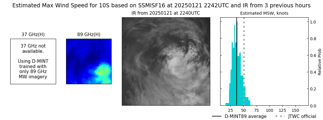 |
| 20250121 | 2213 UTC | SSMISF17 | 995 hPa | 47 kts | 40 kts | 54 kts |  |
| 20250121 | 2004 UTC | SSMISF18 | 990 hPa | 49 kts | 42 kts | 57 kts |  |
| 20250121 | 1924 UTC | TROPICS03 | 987 hPa | 51 kts | 45 kts | 59 kts |  |
| 20250121 | 1756 UTC | AMSR2 | 988 hPa | 50 kts | 43 kts | 58 kts |  |
| 20250121 | 1124 UTC | SSMISF16 | 983 hPa | 51 kts | 45 kts | 57 kts |  |
| 20250121 | 1055 UTC | SSMISF17 | 982 hPa | 57 kts | 51 kts | 63 kts |  |
| 20250121 | 0847 UTC | SSMISF18 | 979 hPa | 64 kts | 58 kts | 70 kts |  |
| 20250121 | 0659 UTC | AMSR2 | 980 hPa | 65 kts | 59 kts | 71 kts |  |
| 20250121 | 0059 UTC | TROPICS03 | 966 hPa | 74 kts | 68 kts | 80 kts |  |
| 20250120 | 2255 UTC | SSMISF16 | 970 hPa | 78 kts | 72 kts | 84 kts |  |
| 20250120 | 2225 UTC | SSMISF17 | 962 hPa | 84 kts | 79 kts | 90 kts |  |
| 20250120 | 2017 UTC | SSMISF18 | 956 hPa | 88 kts | 83 kts | 93 kts |  |
| 20250120 | 1411 UTC | TROPICS05 | 951 hPa | 96 kts | 90 kts | 102 kts |  |
| 20250120 | 1140 UTC | SSMISF16 | 948 hPa | 99 kts | 93 kts | 106 kts | 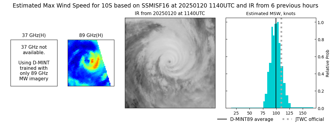 |
| 20250120 | 1110 UTC | SSMISF17 | 946 hPa | 96 kts | 89 kts | 103 kts |  |
| 20250120 | 0901 UTC | SSMISF18 | 945 hPa | 97 kts | 91 kts | 104 kts |  |
| 20250120 | 0733 UTC | TROPICS05 | 947 hPa | 97 kts | 91 kts | 105 kts |  |
| 20250120 | 0631 UTC | ATMS-N20 | 955 hPa | 83 kts | 77 kts | 90 kts |  |
| 20250120 | 0616 UTC | AMSR2 | 952 hPa | 95 kts | 88 kts | 102 kts |  |
| 20250120 | 0606 UTC | ATMS-N20 | 955 hPa | 86 kts | 79 kts | 93 kts |  |
| 20250119 | 2239 UTC | SSMISF17 | 948 hPa | 100 kts | 93 kts | 108 kts |  |
| 20250119 | 2030 UTC | SSMISF18 | 952 hPa | 94 kts | 87 kts | 101 kts |  |
| 20250119 | 1859 UTC | TROPICS03 | 964 hPa | 73 kts | 67 kts | 79 kts |  |
| 20250119 | 1806 UTC | AMSR2 | NaN hPa | 86 kts | 79 kts | 94 kts |  |
| 20250119 | 1736 UTC | ATMS-N20 | 979 hPa | 66 kts | 58 kts | 74 kts |  |
| 20250119 | 1449 UTC | TROPICS05 | 976 hPa | 71 kts | 64 kts | 77 kts |  |
| 20250119 | 0535 UTC | AMSR2 | 991 hPa | 42 kts | 37 kts | 47 kts |  |
| 20250119 | 0215 UTC | TROPICS03 | 991 hPa | 41 kts | 37 kts | 46 kts |  |
| 20250119 | 0214 UTC | TROPICS03 | 991 hPa | 41 kts | 37 kts | 46 kts |  |
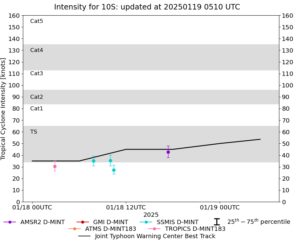
| 20250118 | 1723 UTC | AMSR2 | 990 hPa | 43 kts | 38 kts | 48 kts | 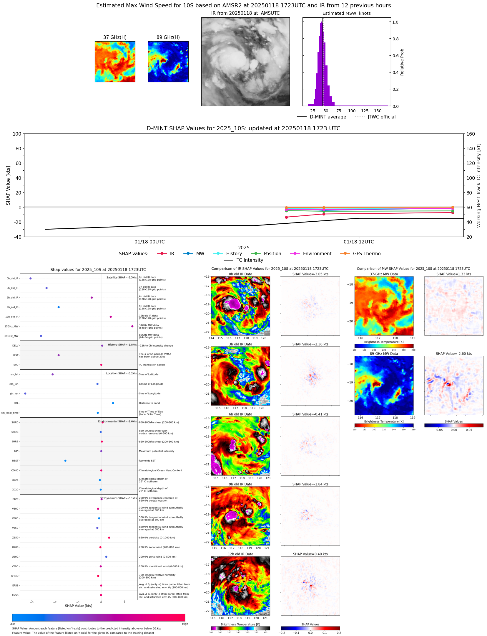 |
| 20250118 | 1026 UTC | SSMISF16 | 999 hPa | 27 kts | 24 kts | 31 kts | 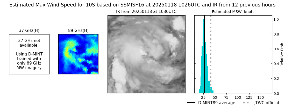 |
| 20250118 | 0959 UTC | SSMISF17 | 1000 hPa | 35 kts | 31 kts | 40 kts | 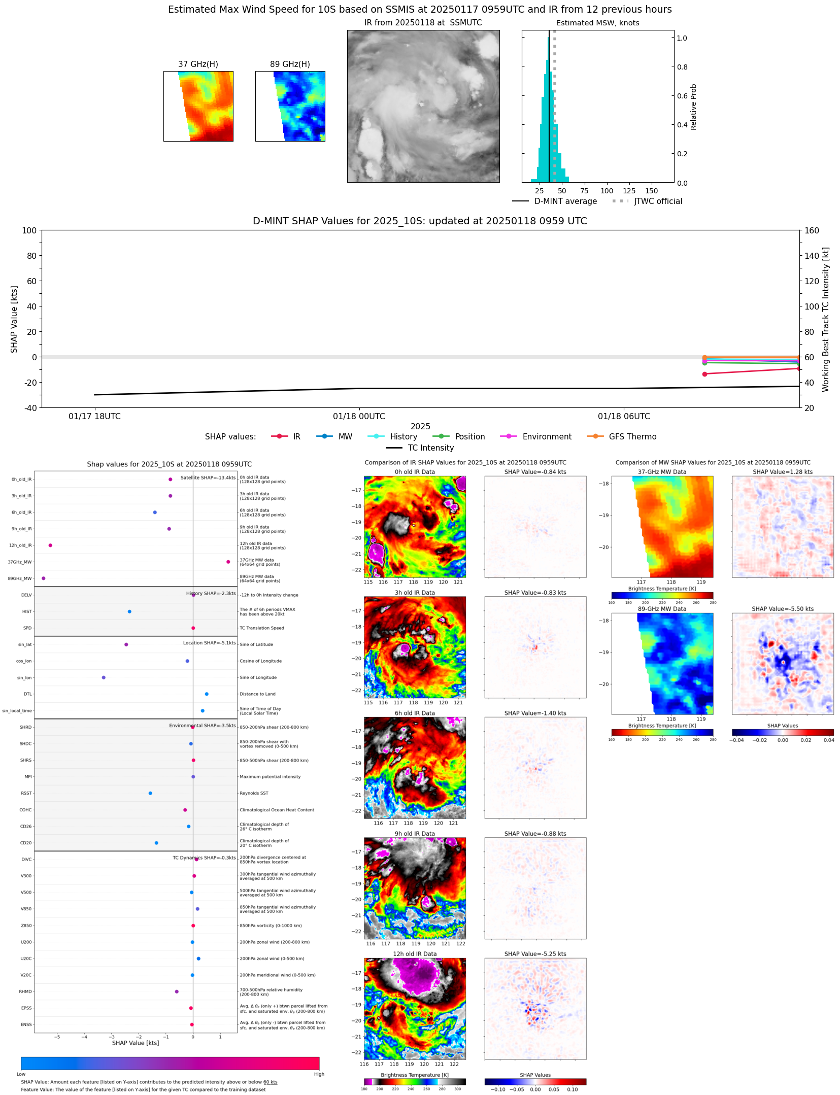 |
| 20250118 | 0750 UTC | SSMISF18 | 997 hPa | 35 kts | 31 kts | 39 kts | 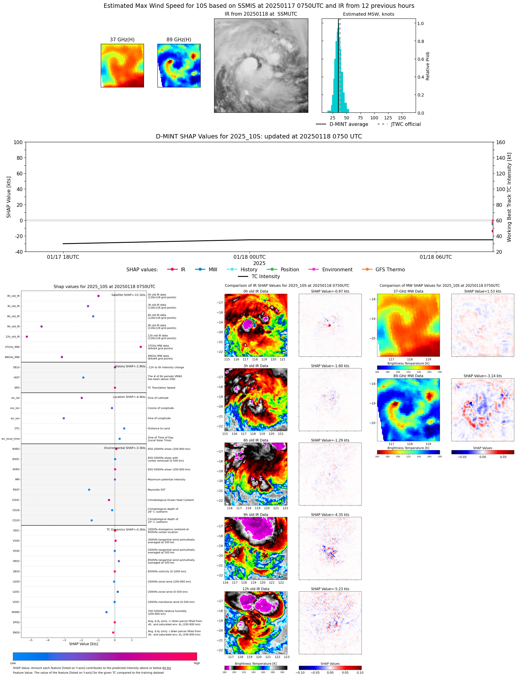 |
| 20250118 | 0252 UTC | TROPICS03 | 1000 hPa | 30 kts | 26 kts | 35 kts | 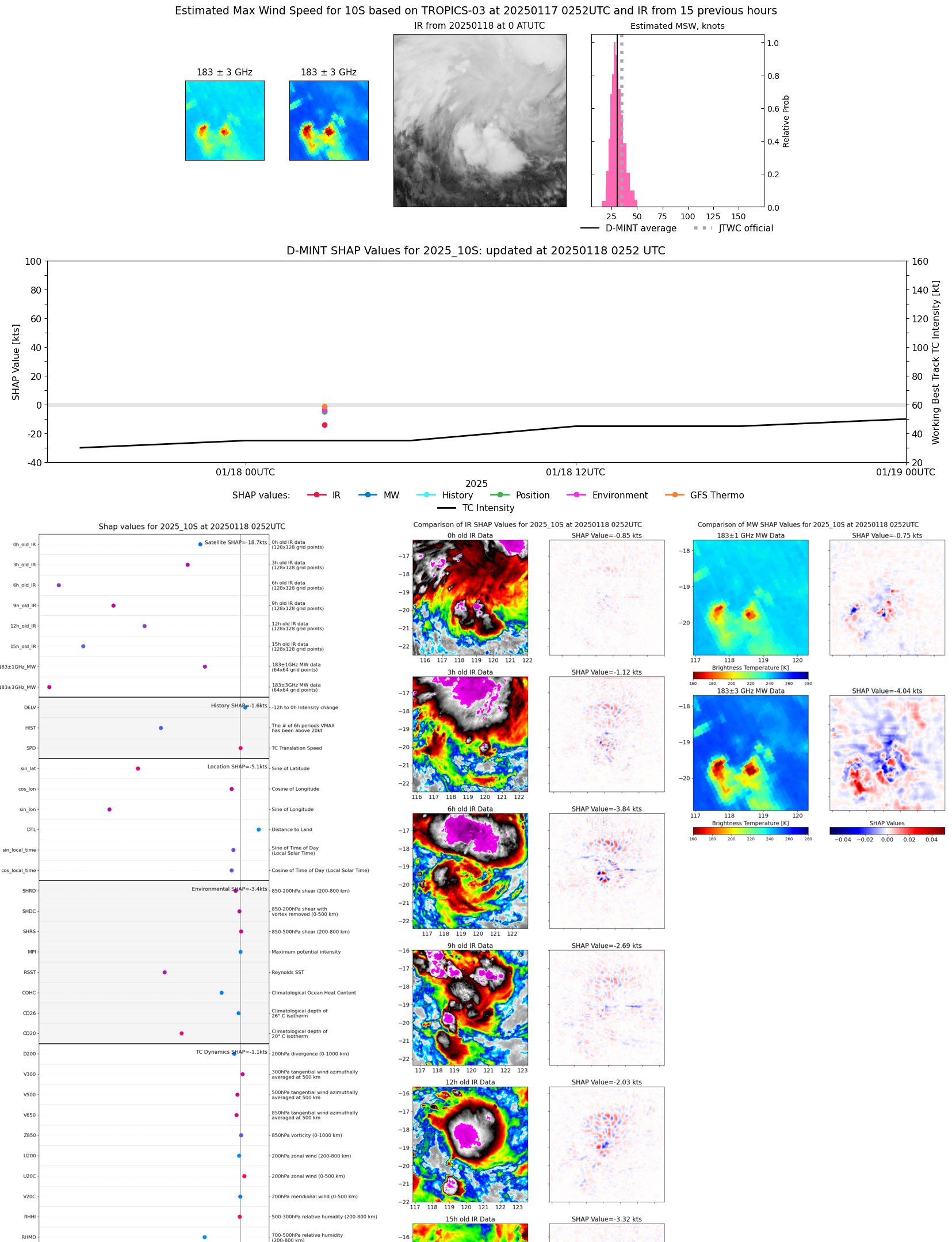 |