|
||

 |
D-MINT HISTORY FILE for 2025_21W
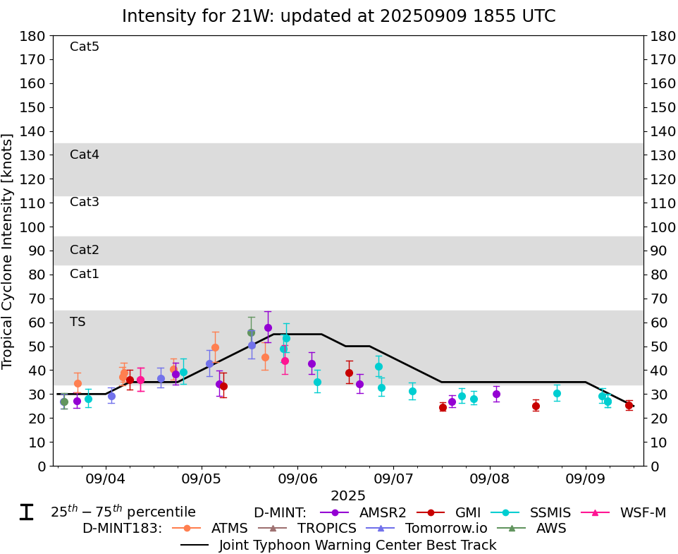
| Date | Time | MW Sensor | MSLP | Vmax (30th-70th percentile average) | Vmax 25th percentile | Vmax 75th percentile | Image |
| 20250909 | 1052 UTC | GMI | 1002 hPa | 25 kts | 23 kts | 27 kts | 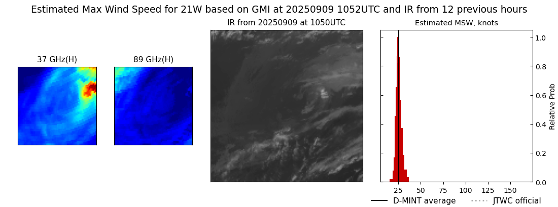 |
| 20250909 | 0530 UTC | SSMISF17 | 1001 hPa | 27 kts | 25 kts | 30 kts | 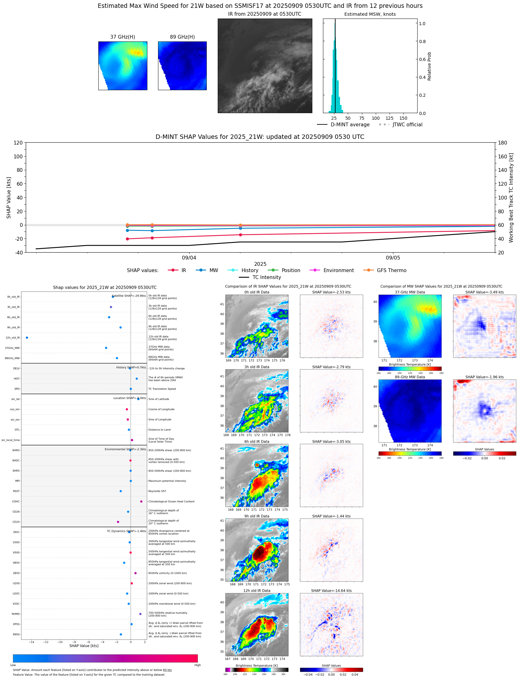 |
| 20250909 | 0529 UTC | SSMISF17 | 1001 hPa | 27 kts | 24 kts | 30 kts |  |
| 20250909 | 0409 UTC | SSMISF18 | 999 hPa | 29 kts | 26 kts | 32 kts |  |
| 20250908 | 1646 UTC | SSMISF18 | 998 hPa | 30 kts | 27 kts | 34 kts |  |
| 20250908 | 1134 UTC | GMI | 1003 hPa | 25 kts | 23 kts | 28 kts | 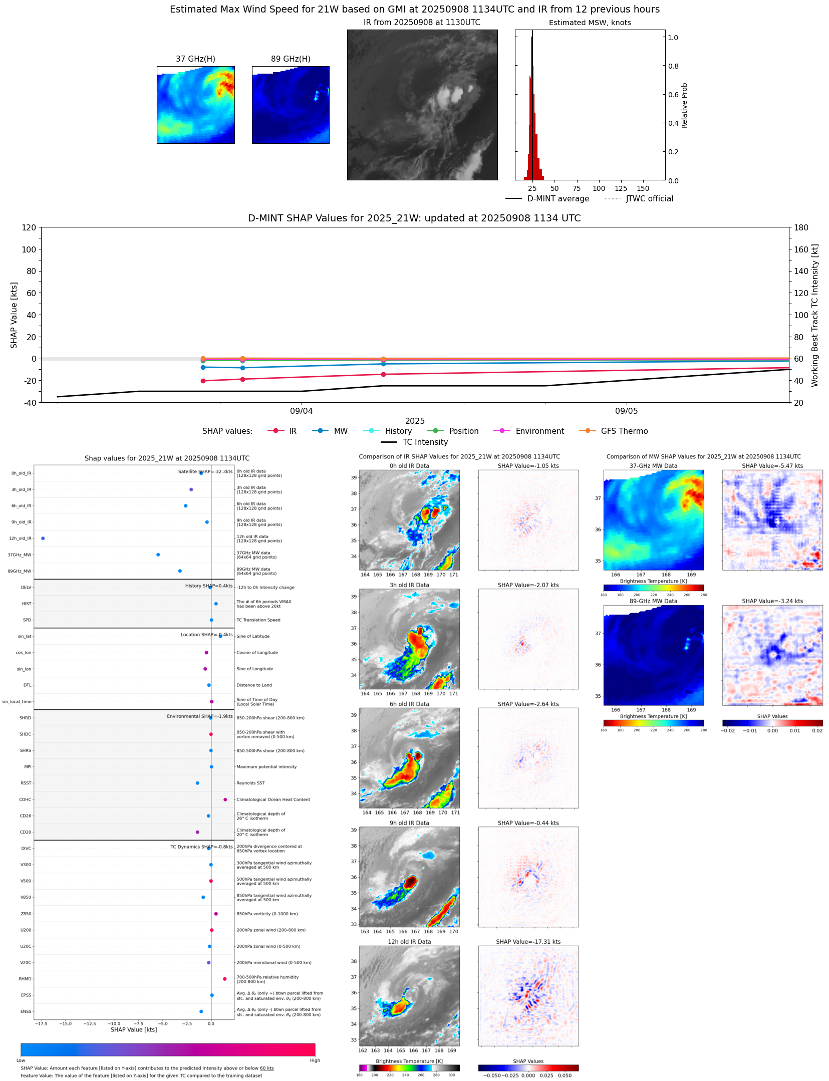 |
| 20250908 | 0140 UTC | AMSR2 | 1002 hPa | 30 kts | 27 kts | 33 kts | 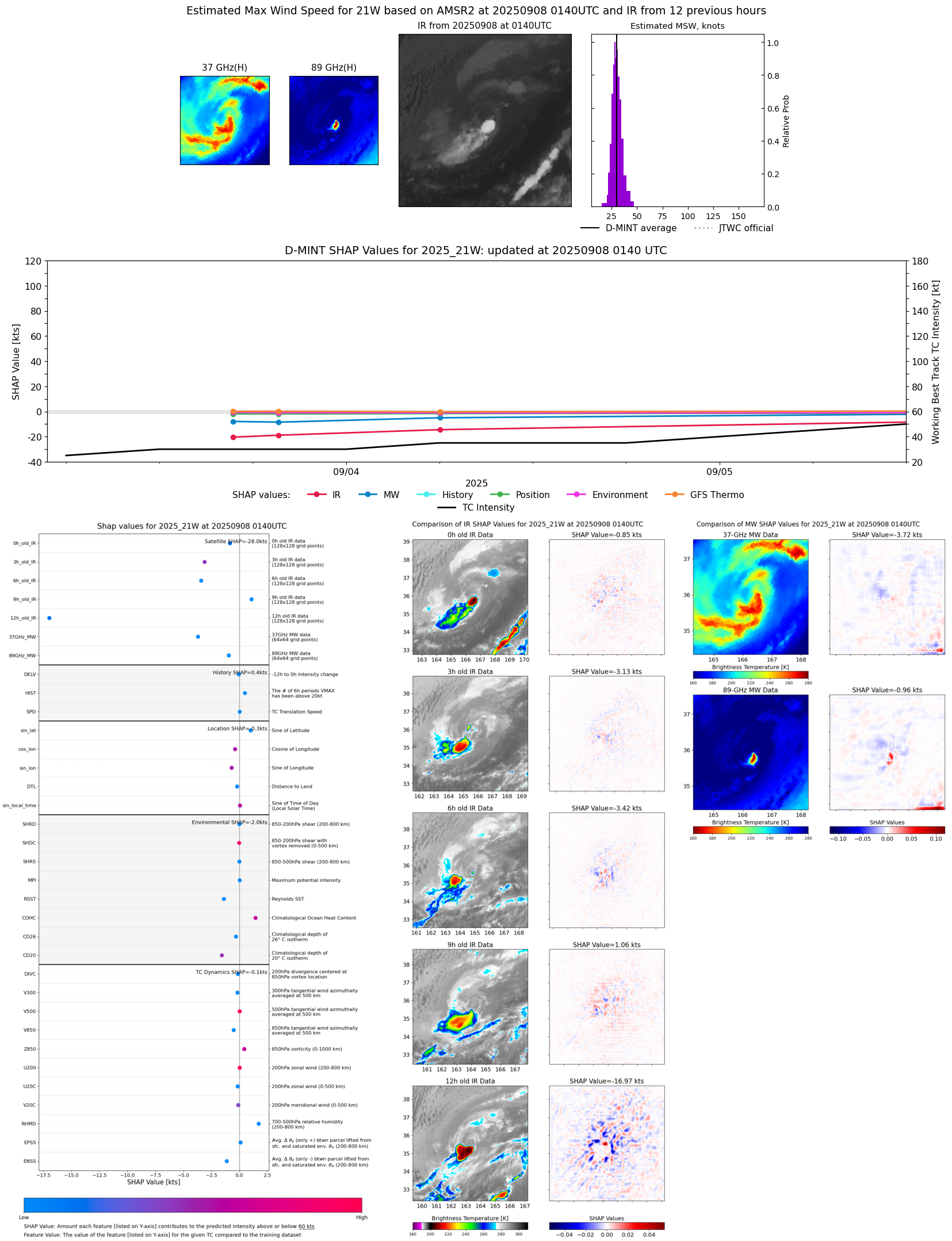 |
| 20250907 | 2002 UTC | SSMISF17 | 1002 hPa | 28 kts | 26 kts | 31 kts | 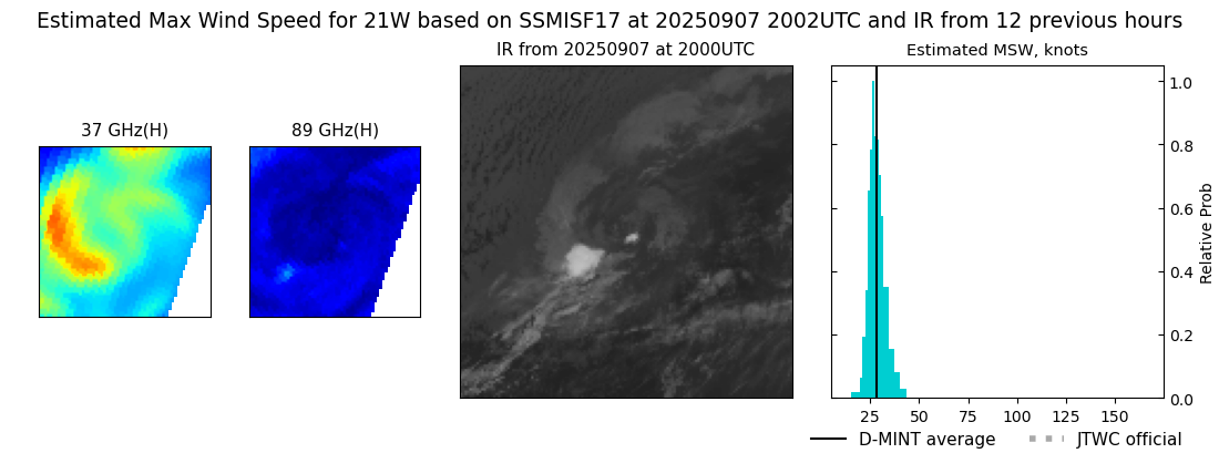 |
| 20250907 | 1701 UTC | SSMISF18 | 1001 hPa | 29 kts | 26 kts | 32 kts | 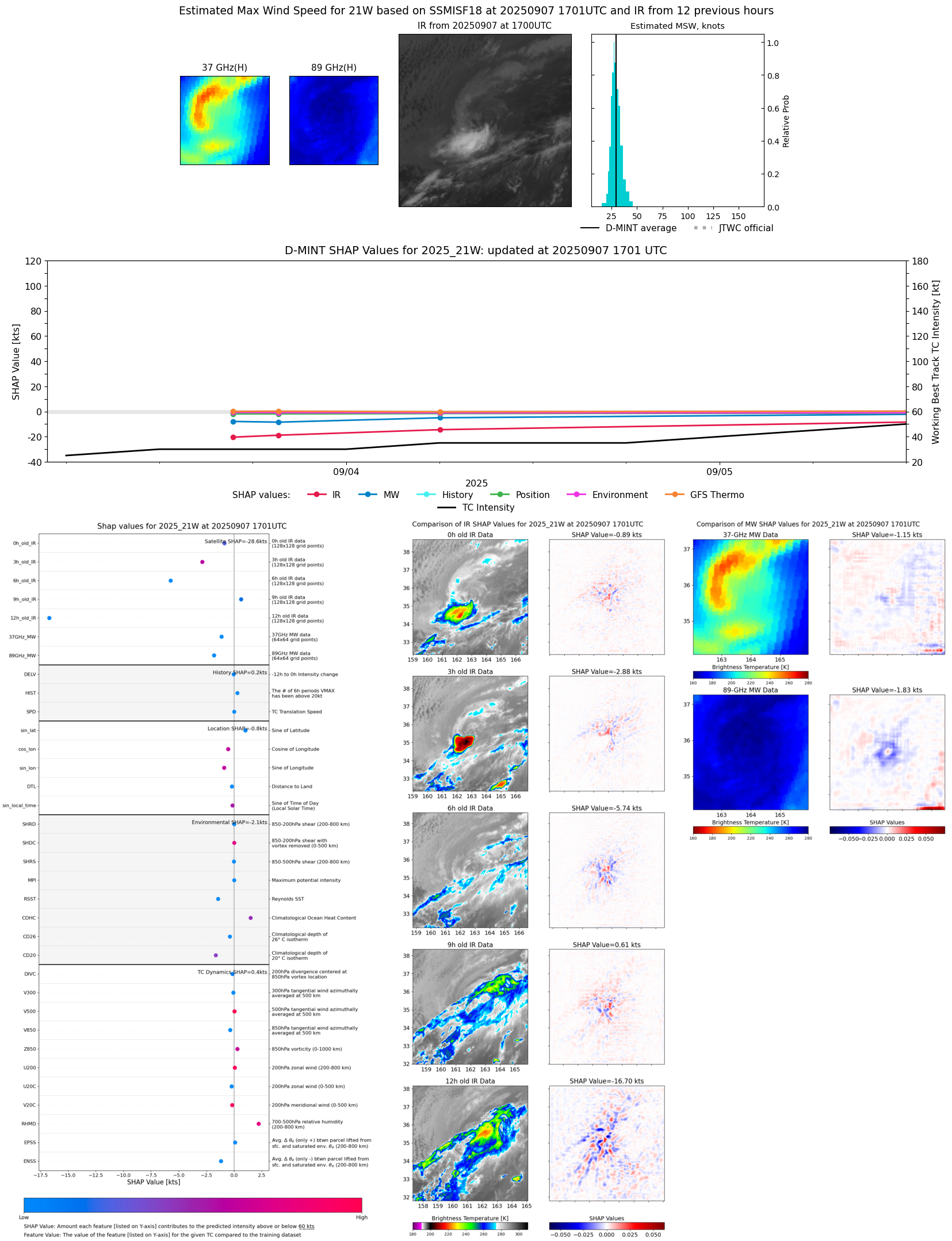 |
| 20250907 | 1437 UTC | AMSR2 | 1002 hPa | 27 kts | 25 kts | 30 kts |  |
| 20250907 | 1215 UTC | GMI | 1004 hPa | 25 kts | 23 kts | 27 kts | 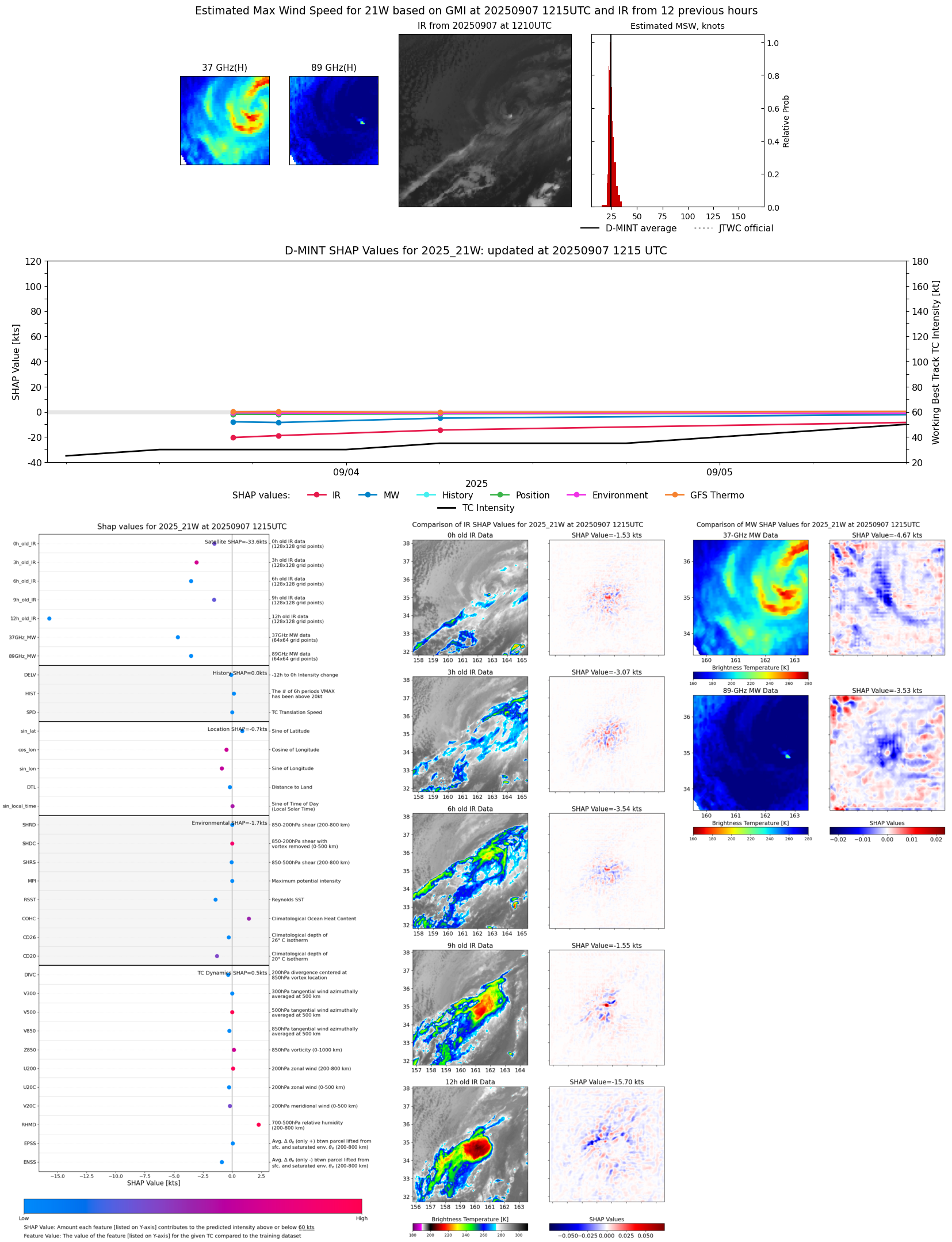 |
| 20250907 | 0436 UTC | SSMISF18 | 1001 hPa | 31 kts | 28 kts | 35 kts | 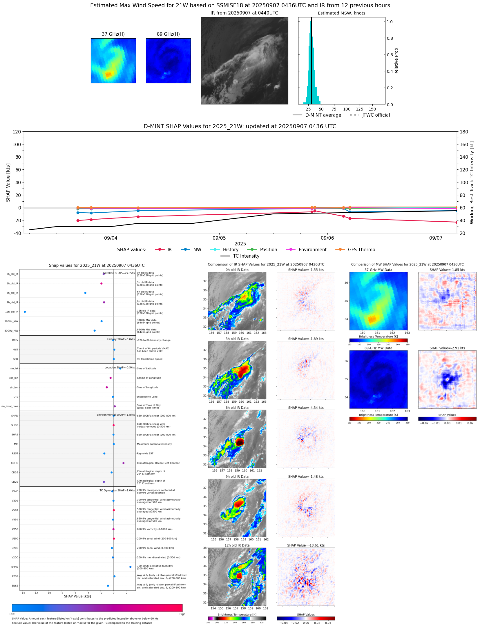 |
| 20250906 | 2053 UTC | SSMISF16 | NaN hPa | 33 kts | 29 kts | 37 kts | 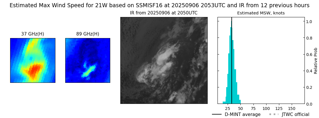 |
| 20250906 | 2016 UTC | SSMISF17 | NaN hPa | 42 kts | 37 kts | 46 kts | 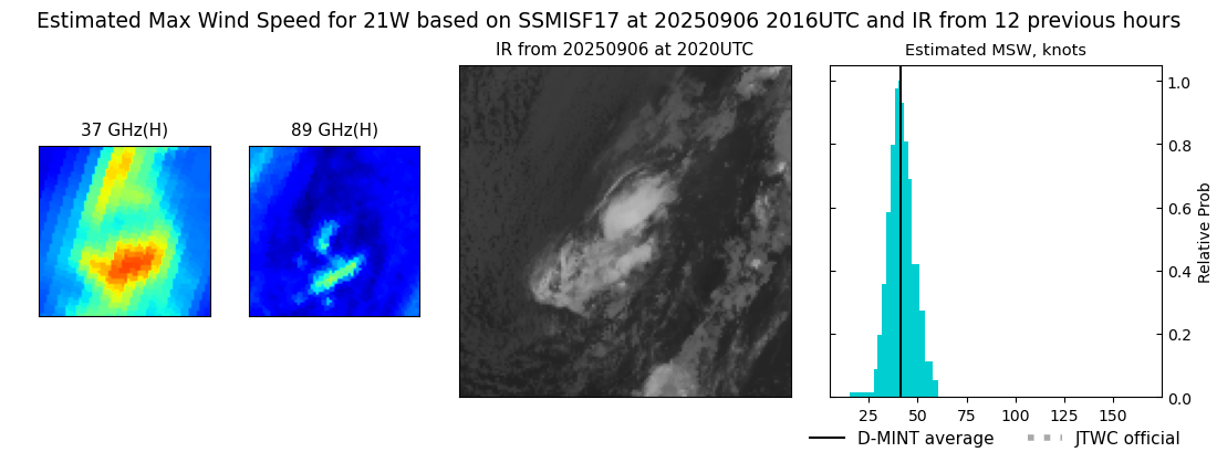 |
| 20250906 | 1532 UTC | AMSR2 | NaN hPa | 34 kts | 30 kts | 38 kts |  |
| 20250906 | 1253 UTC | GMI | NaN hPa | 39 kts | 35 kts | 44 kts |  |
| 20250906 | 0453 UTC | SSMISF18 | 993 hPa | 35 kts | 31 kts | 40 kts | 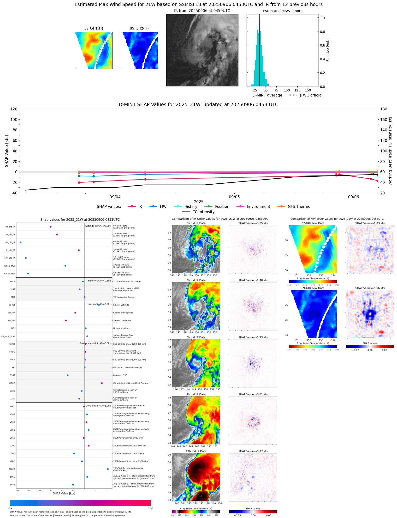 |
| 20250906 | 0331 UTC | AMSR2 | 994 hPa | 43 kts | 38 kts | 48 kts | 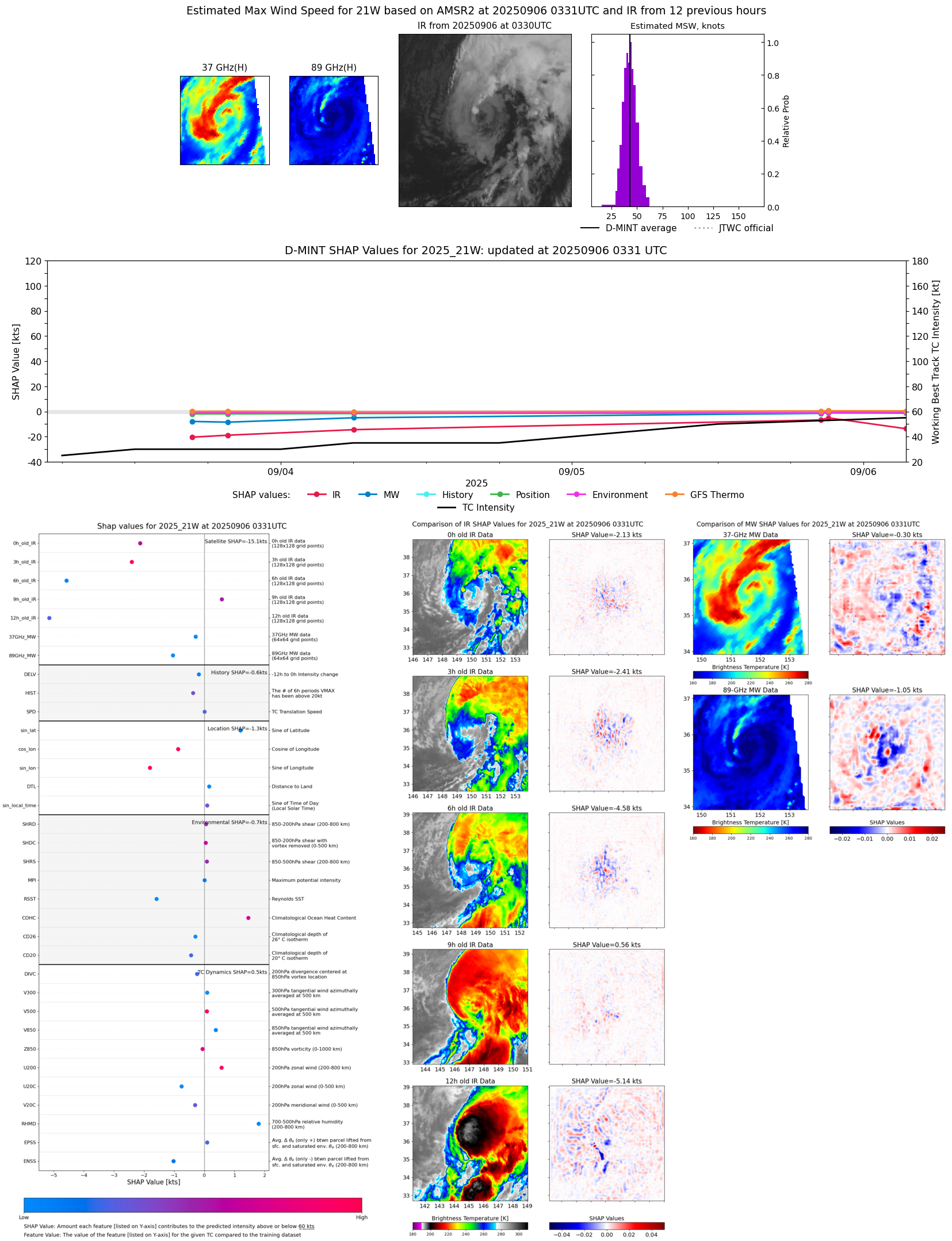 |
| 20250905 | 2107 UTC | SSMISF16 | 990 hPa | 53 kts | 47 kts | 59 kts | 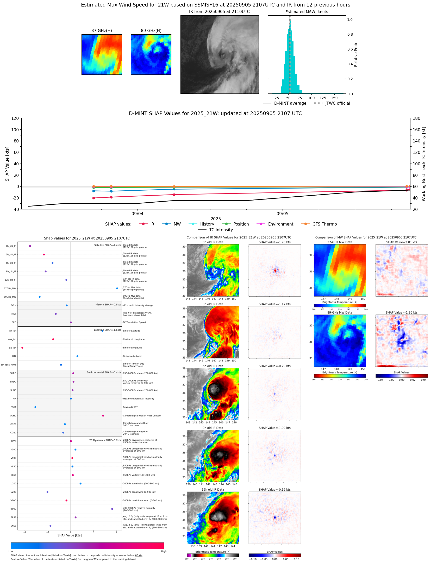 |
| 20250905 | 2045 UTC | WSFM01 | 992 hPa | 44 kts | 38 kts | 51 kts | 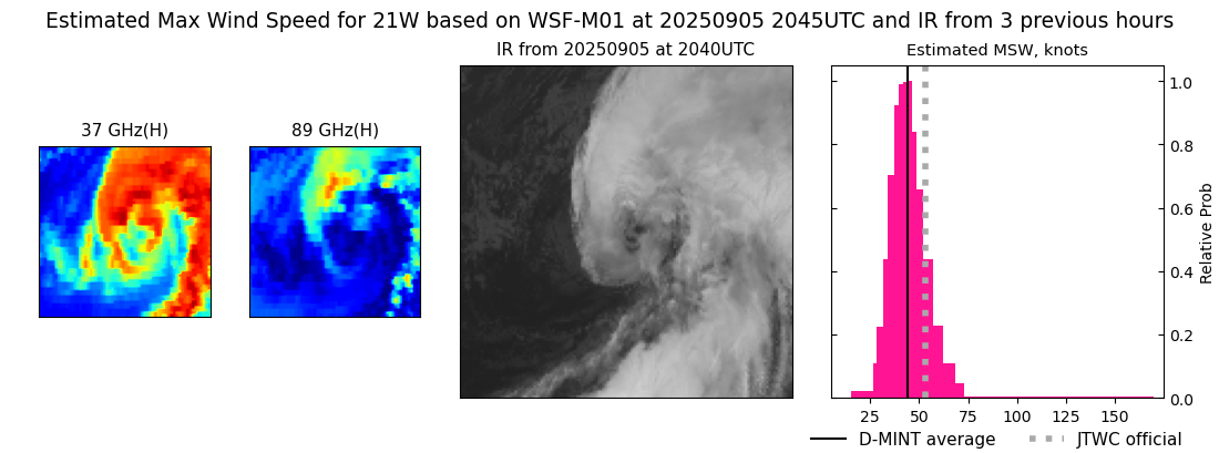 |
| 20250905 | 2030 UTC | SSMISF17 | 990 hPa | 49 kts | 43 kts | 55 kts | 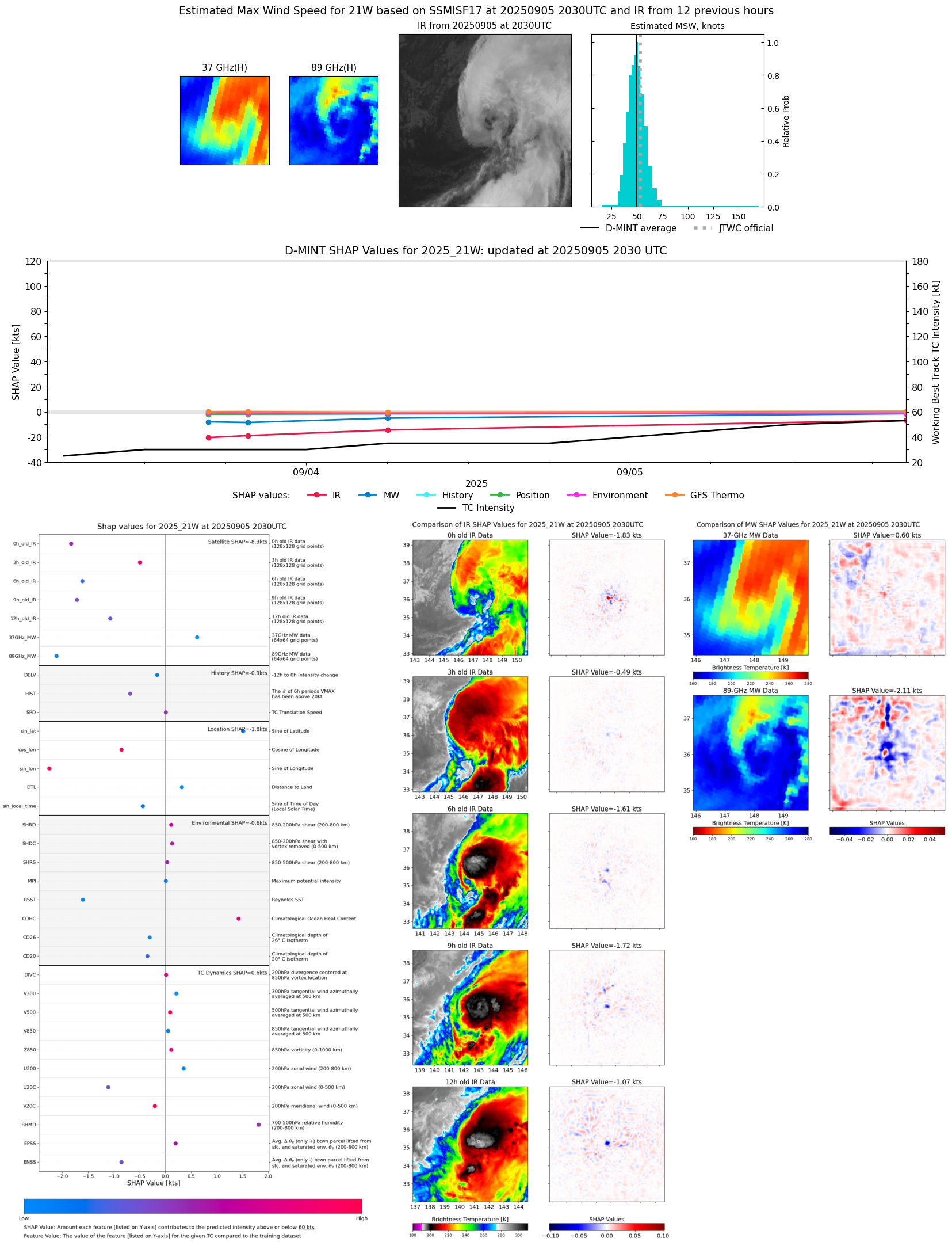 |
| 20250905 | 1628 UTC | AMSR2 | 985 hPa | 58 kts | 52 kts | 65 kts |  |
| 20250905 | 1546 UTC | ATMS-N21 | 987 hPa | 46 kts | 40 kts | 52 kts | 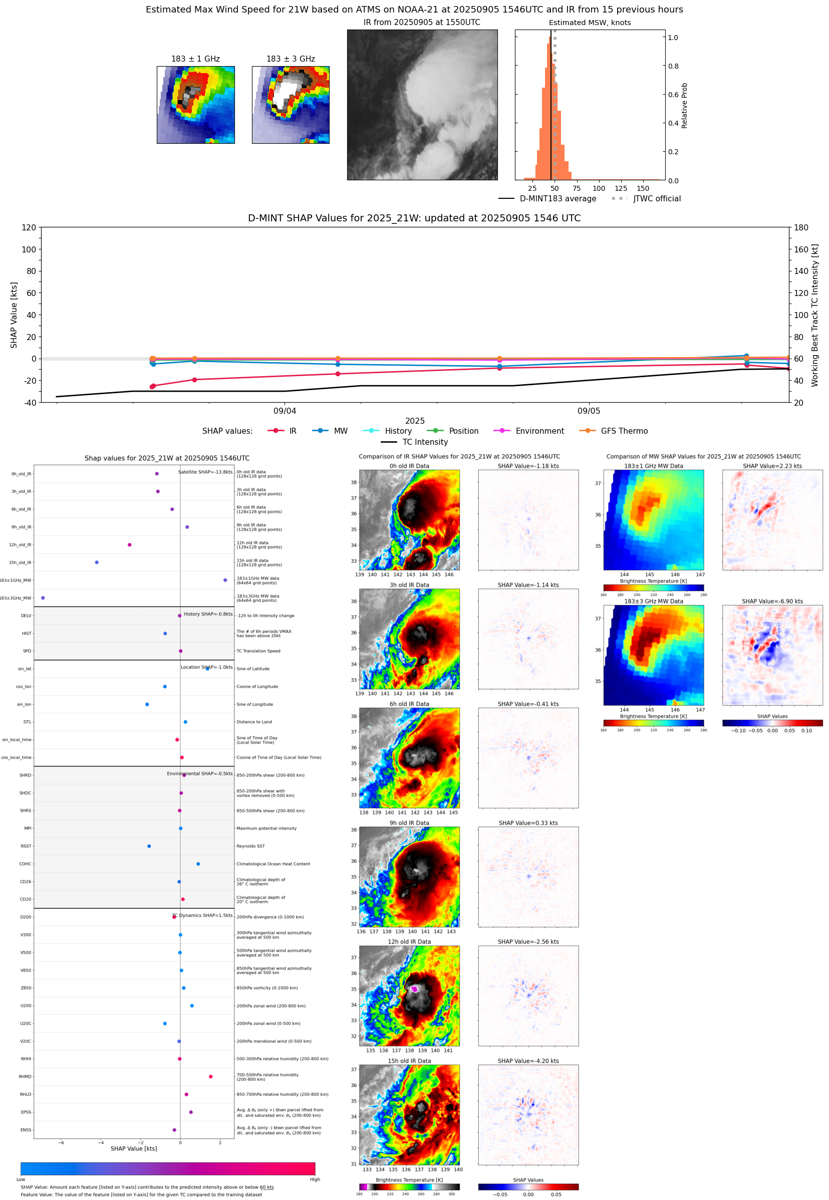 |
| 20250905 | 1226 UTC | TMS02 | 988 hPa | 51 kts | 45 kts | 57 kts |  |
| 20250905 | 1224 UTC | AWS | 985 hPa | 56 kts | 50 kts | 62 kts | 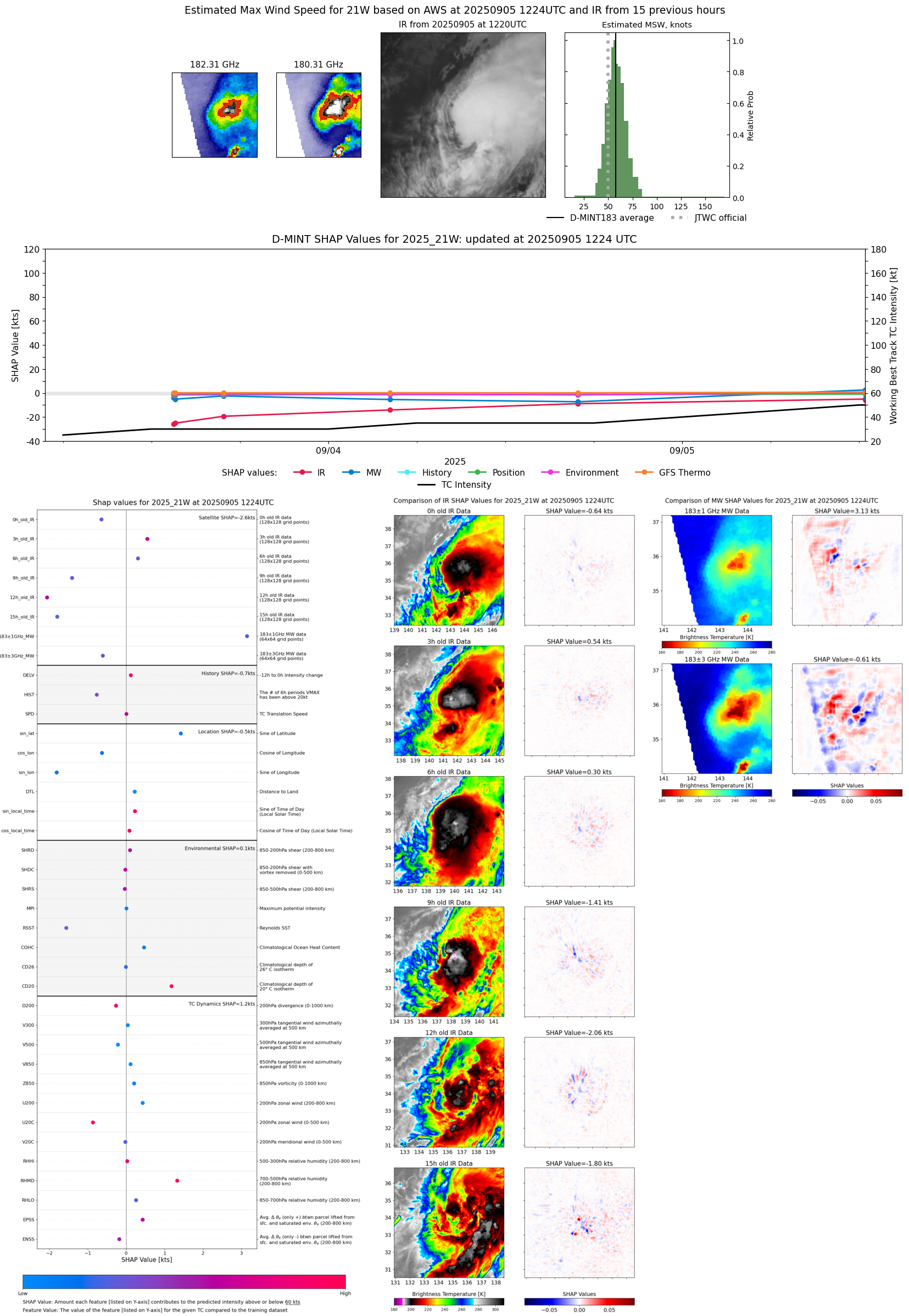 |
| 20250905 | 0523 UTC | GMI | NaN hPa | 33 kts | 29 kts | 39 kts |  |
| 20250905 | 0426 UTC | AMSR2 | NaN hPa | 34 kts | 29 kts | 40 kts |  |
| 20250905 | 0157 UTC | TMS02 | NaN hPa | 43 kts | 38 kts | 48 kts |  |
| 20250904 | 1925 UTC | SSMISF18 | 991 hPa | 39 kts | 34 kts | 45 kts |  |
| 20250904 | 1725 UTC | AMSR2 | 995 hPa | 38 kts | 34 kts | 43 kts | 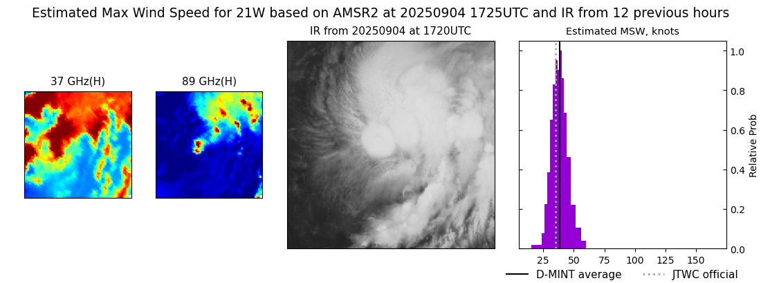 |
| 20250904 | 1655 UTC | ATMS-N20 | 995 hPa | 40 kts | 36 kts | 45 kts | 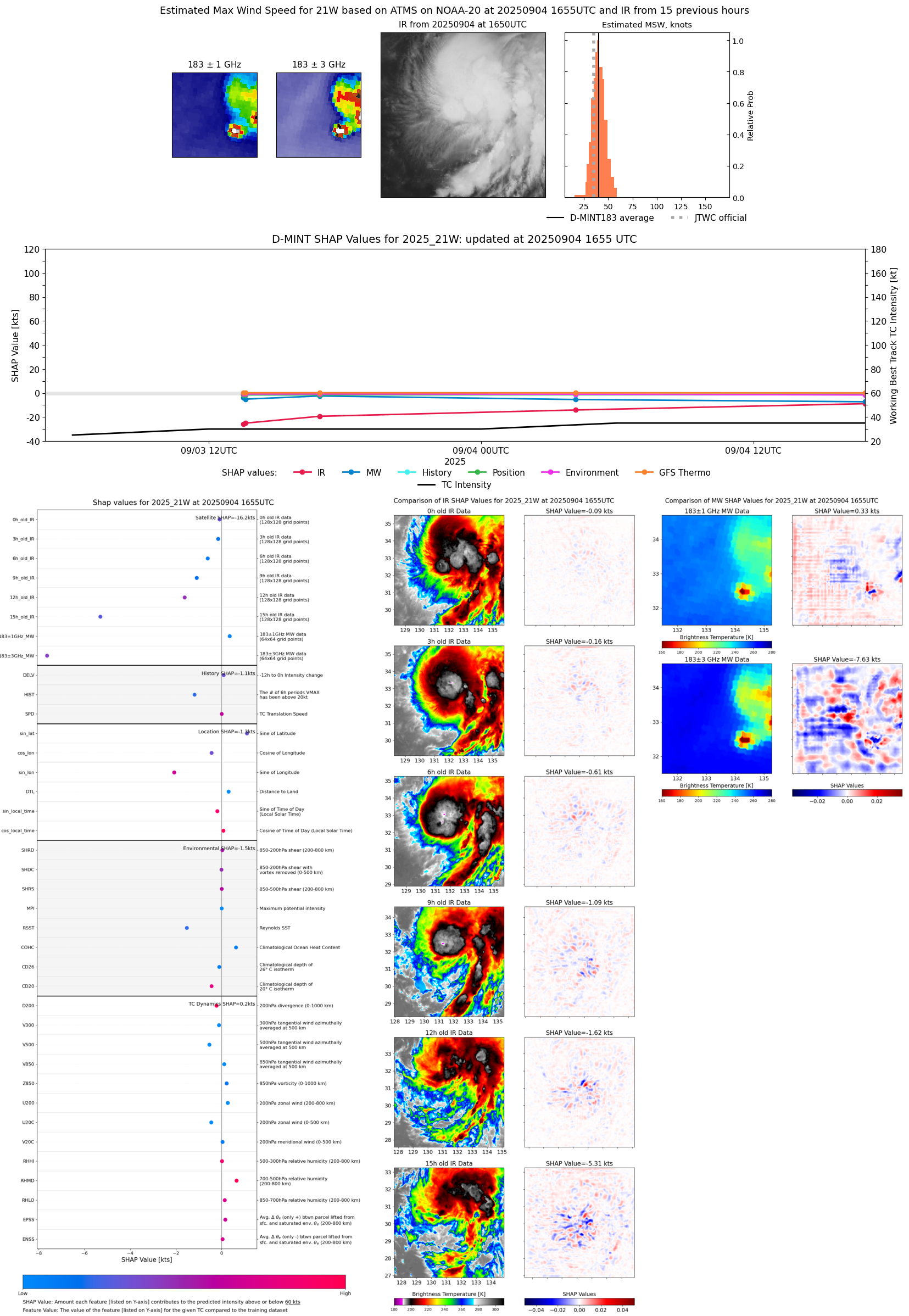 |
| 20250904 | 1341 UTC | TMS06 | 1000 hPa | 37 kts | 33 kts | 41 kts |  |
| 20250904 | 0844 UTC | WSFM01 | 1001 hPa | 36 kts | 31 kts | 41 kts |  |
| 20250904 | 0844 UTC | WSFM01 | 1001 hPa | 36 kts | 31 kts | 41 kts |  |
| 20250904 | 0603 UTC | GMI | 1003 hPa | 36 kts | 32 kts | 40 kts | 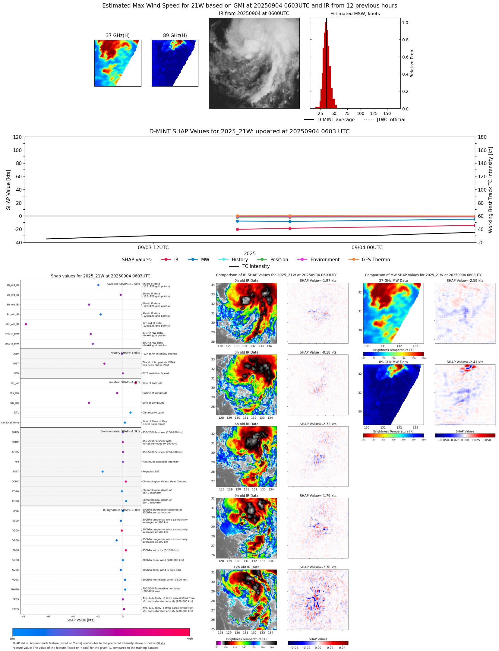 |
| 20250904 | 0431 UTC | ATMS-N20 | 1000 hPa | 39 kts | 35 kts | 43 kts | 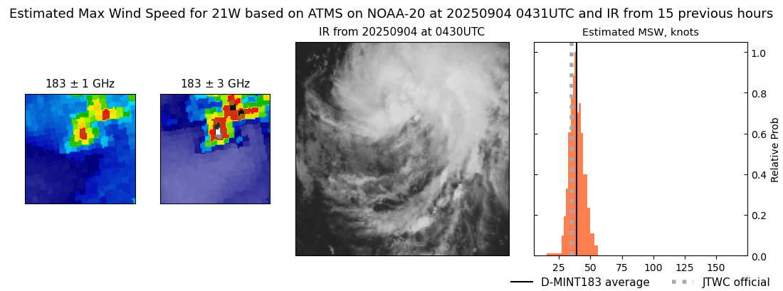 |
| 20250904 | 0410 UTC | ATMS-NPP | 1002 hPa | 37 kts | 34 kts | 41 kts | 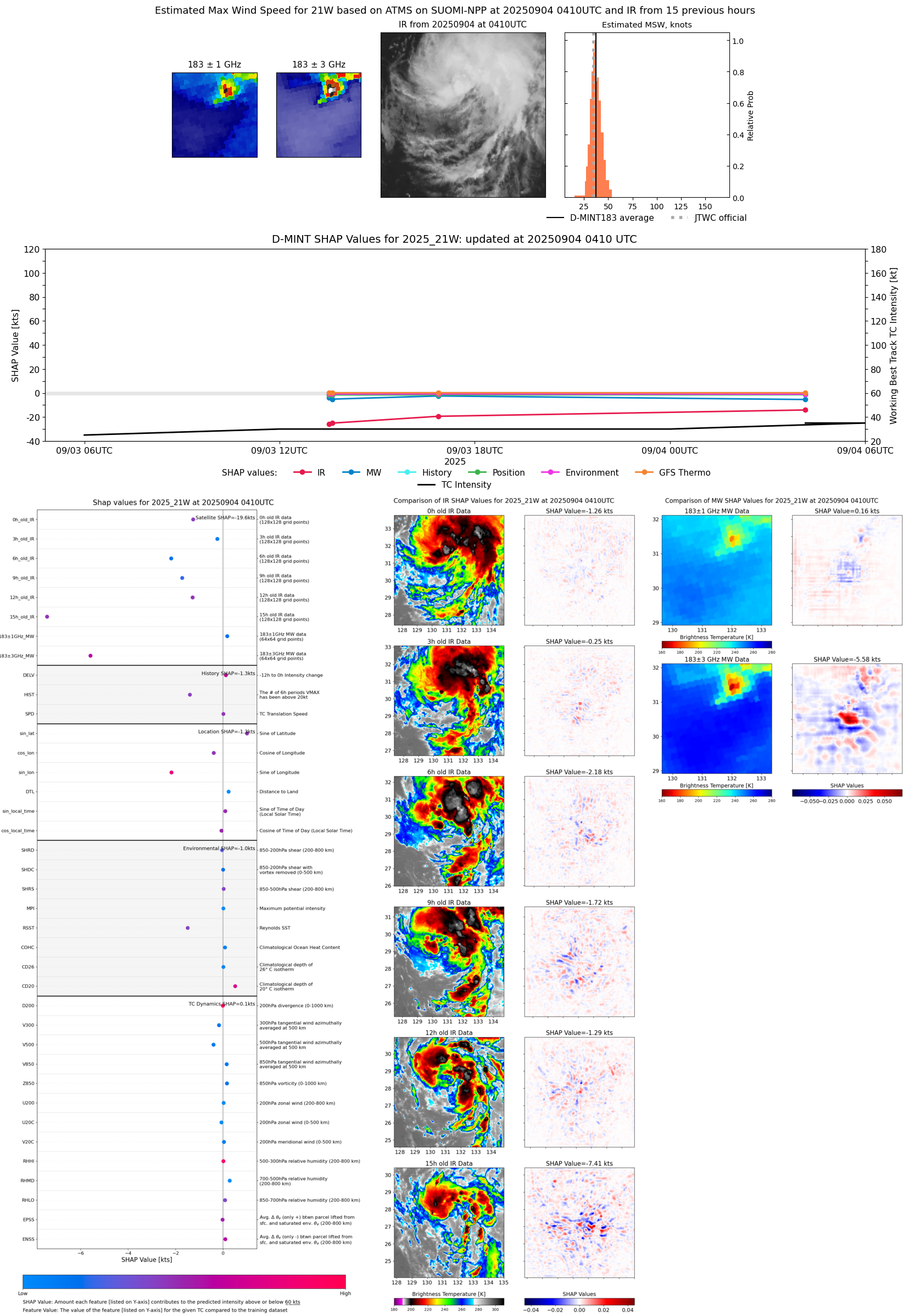 |
| 20250904 | 0121 UTC | TMS05 | 1000 hPa | 29 kts | 26 kts | 33 kts | 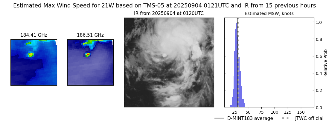 |
| 20250903 | 1940 UTC | SSMISF18 | 999 hPa | 28 kts | 25 kts | 32 kts | 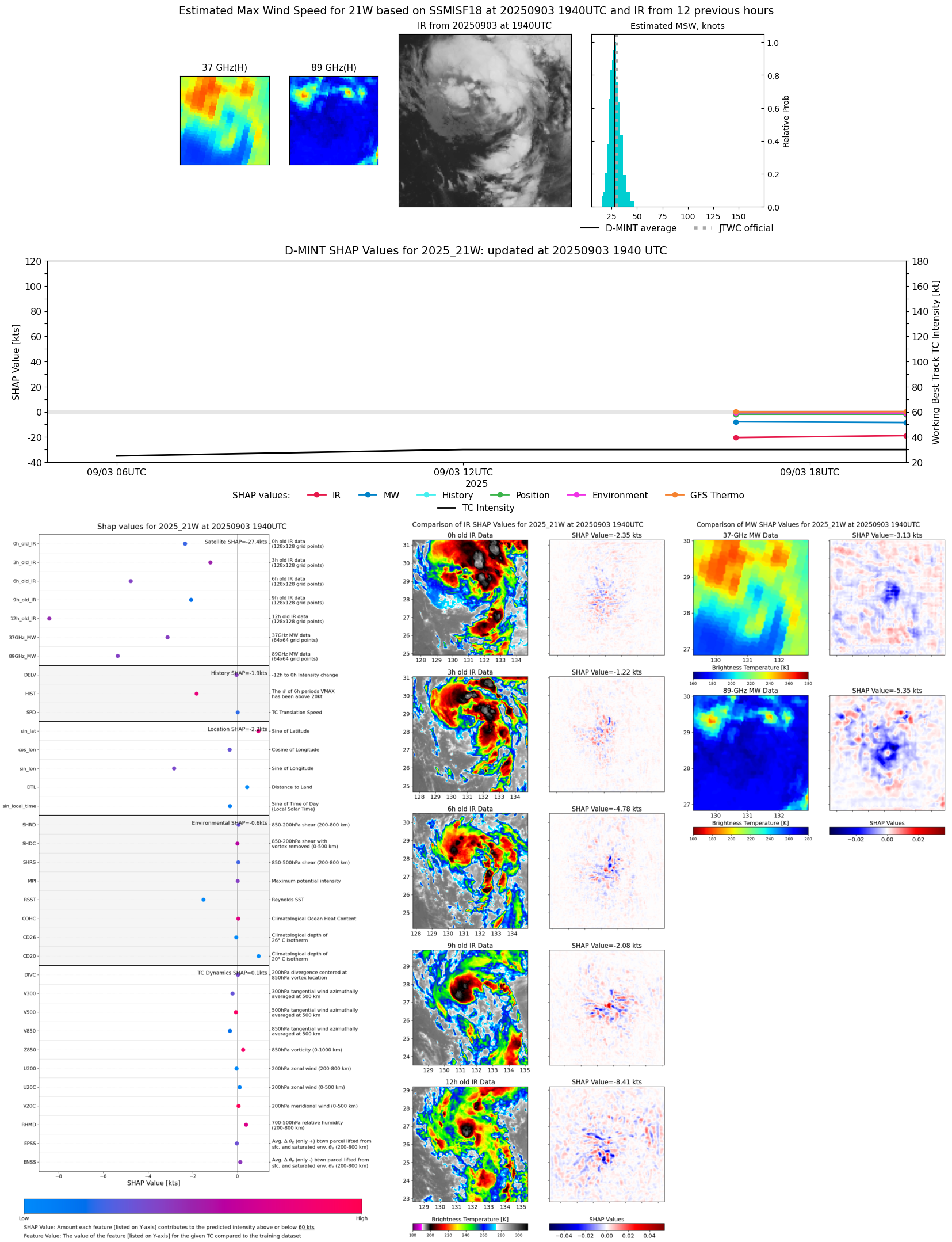 |
| 20250903 | 1653 UTC | ATMS-NPP | 999 hPa | 35 kts | 31 kts | 39 kts | 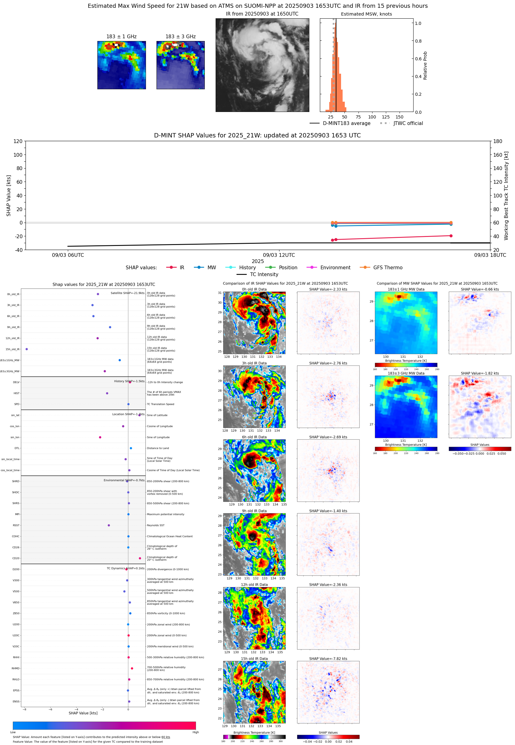 |
| 20250903 | 1643 UTC | AMSR2 | 1001 hPa | 27 kts | 24 kts | 31 kts | 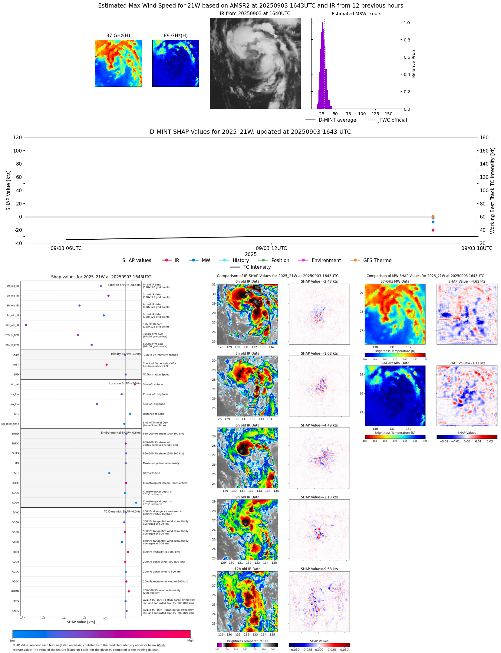 |
| 20250903 | 1337 UTC | AWS | 1001 hPa | 27 kts | 24 kts | 30 kts | 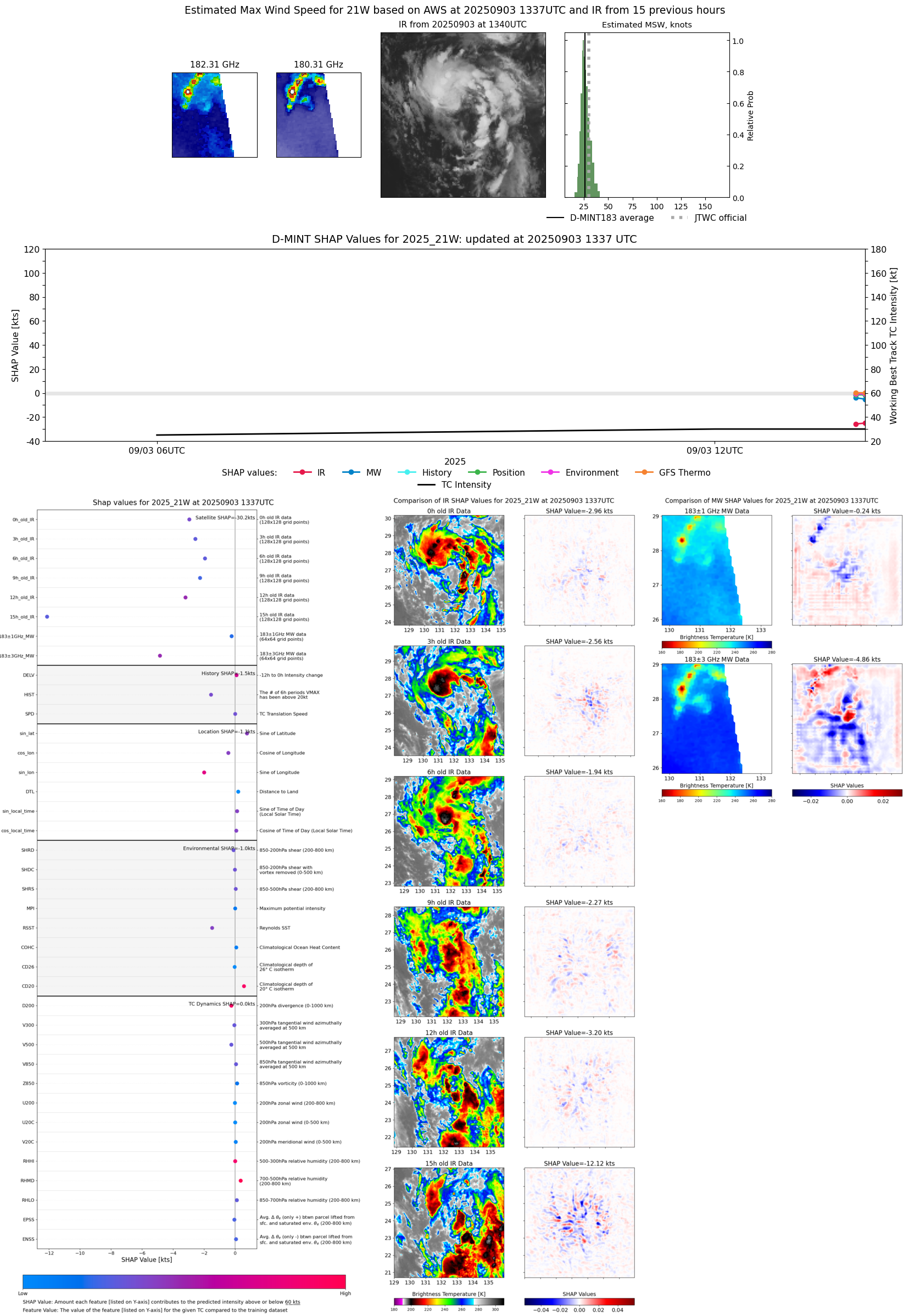 |
| 20250903 | 1331 UTC | TMS02 | 1001 hPa | 27 kts | 24 kts | 30 kts | 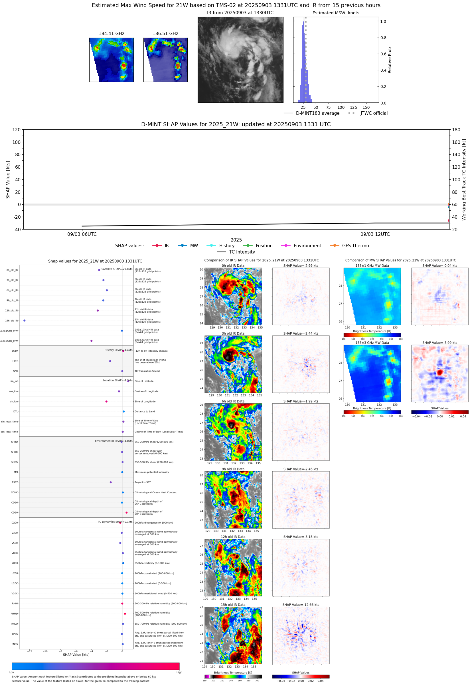 |
| 20250903 | 0903 UTC | WSFM01 | 1002 hPa | 26 kts | 23 kts | 29 kts | 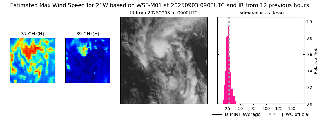 |