|
||

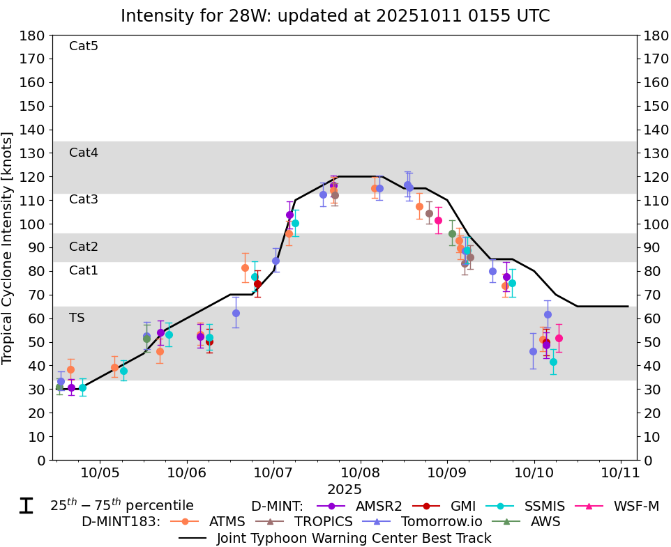 |
D-MINT HISTORY FILE for 2025_28W
| Date | Time | MW Sensor | MSLP | Vmax (30th-70th percentile average) | Vmax 25th percentile | Vmax 75th percentile | Image |
| 20251010 | 0648 UTC | WSFM01 | 988 hPa | 52 kts | 46 kts | 58 kts | 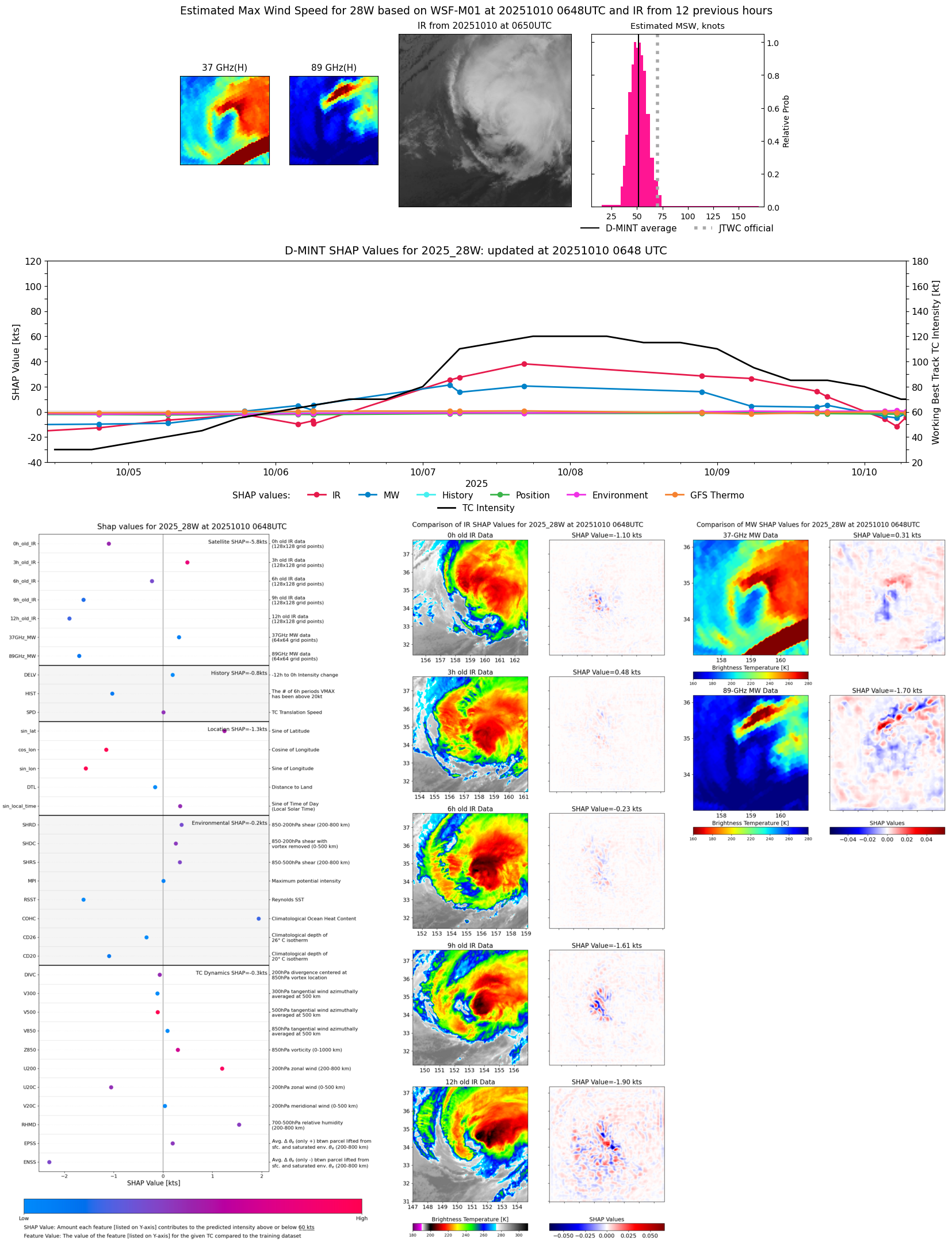 |
| 20251010 | 0517 UTC | SSMISF18 | 999 hPa | 42 kts | 36 kts | 47 kts | 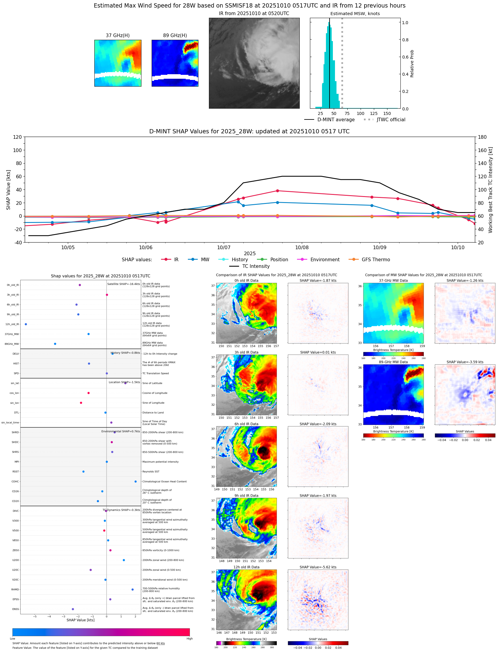 |
| 20251010 | 0340 UTC | TMS07 | 981 hPa | 62 kts | 56 kts | 67 kts |  |
| 20251010 | 0318 UTC | AMSR2 | 994 hPa | 50 kts | 44 kts | 55 kts |  |
| 20251010 | 0318 UTC | GMI | 994 hPa | 50 kts | 44 kts | 55 kts | 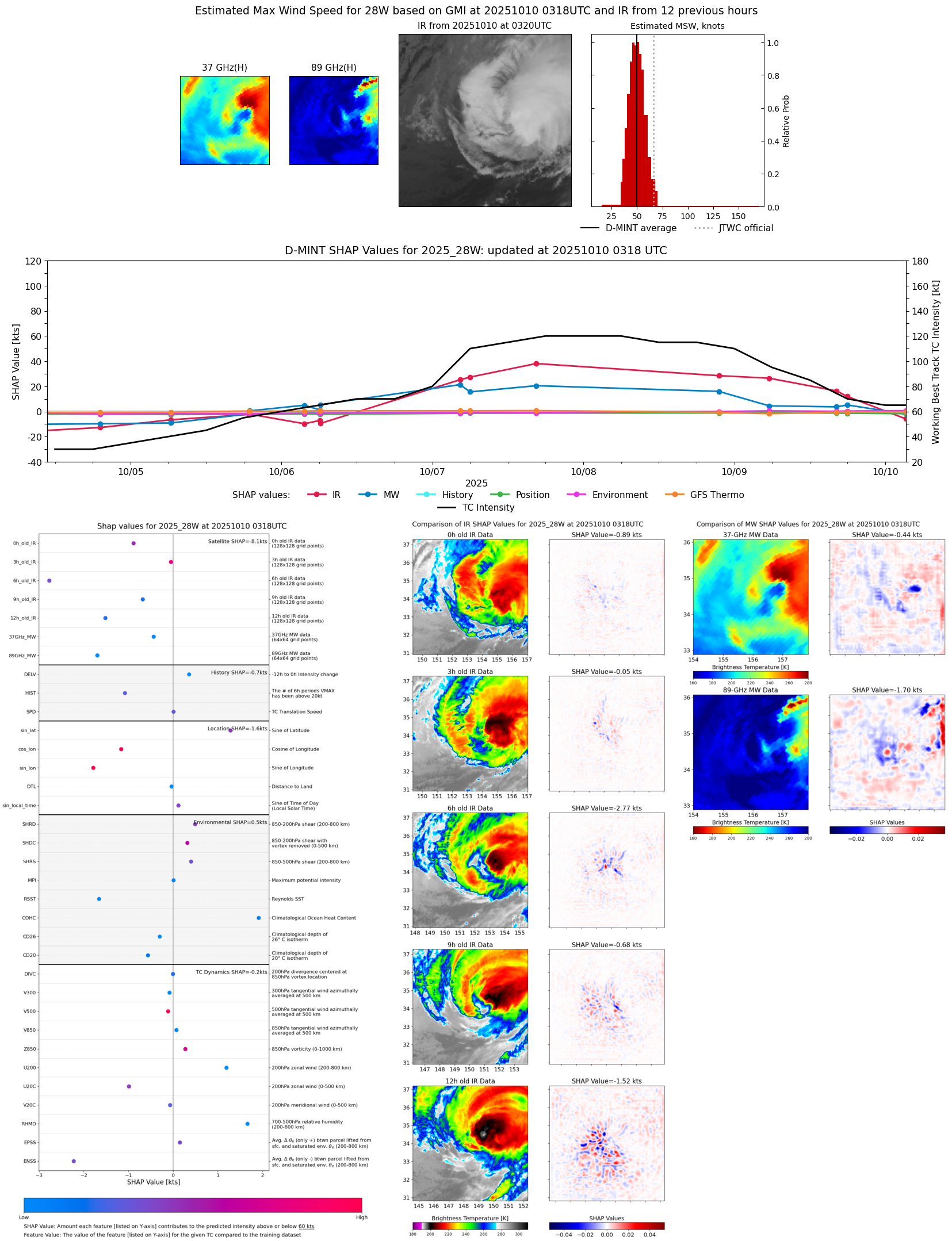 |
| 20251010 | 0227 UTC | ATMS-N21 | 988 hPa | 51 kts | 46 kts | 56 kts |  |
| 20251009 | 2343 UTC | TMS06 | 992 hPa | 46 kts | 39 kts | 54 kts |  |
| 20251009 | 1758 UTC | SSMISF18 | 985 hPa | 75 kts | 69 kts | 81 kts |  |
| 20251009 | 1616 UTC | AMSR2 | 979 hPa | 78 kts | 71 kts | 84 kts |  |
| 20251009 | 1557 UTC | ATMS-N20 | 970 hPa | 74 kts | 69 kts | 79 kts | 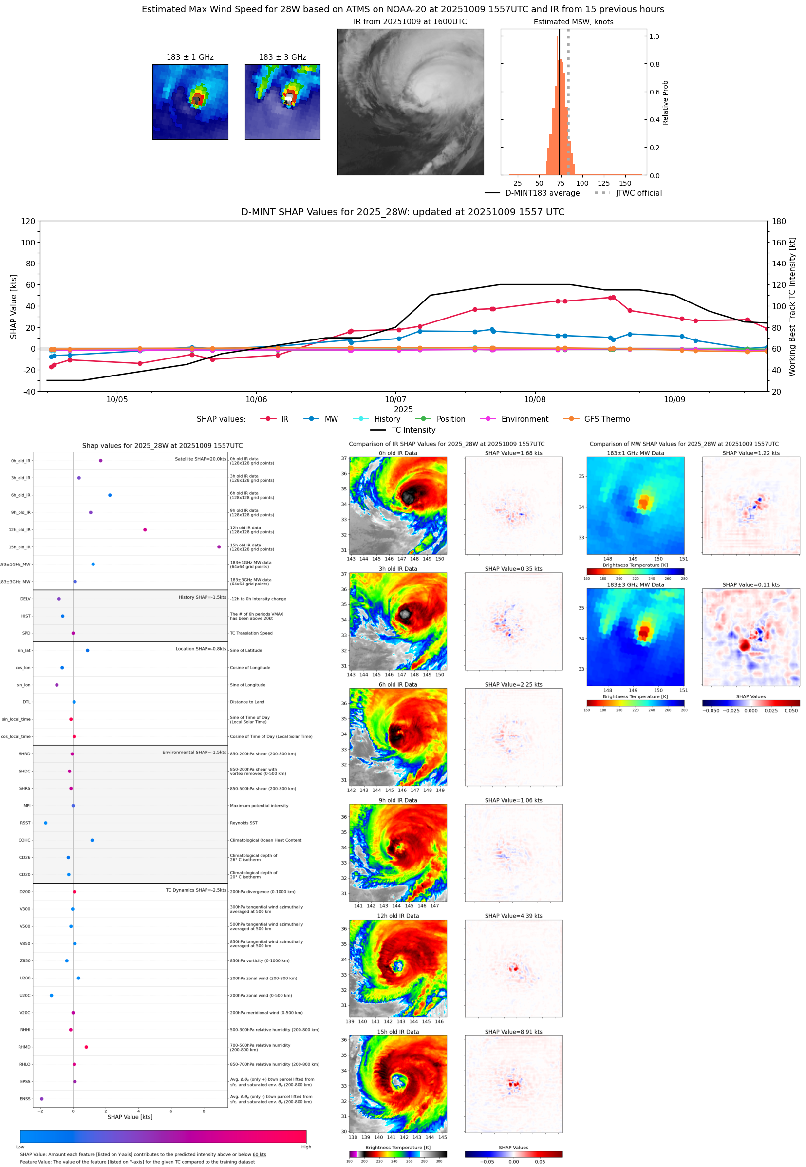 |
| 20251009 | 1233 UTC | TMS02 | 966 hPa | 80 kts | 75 kts | 85 kts | 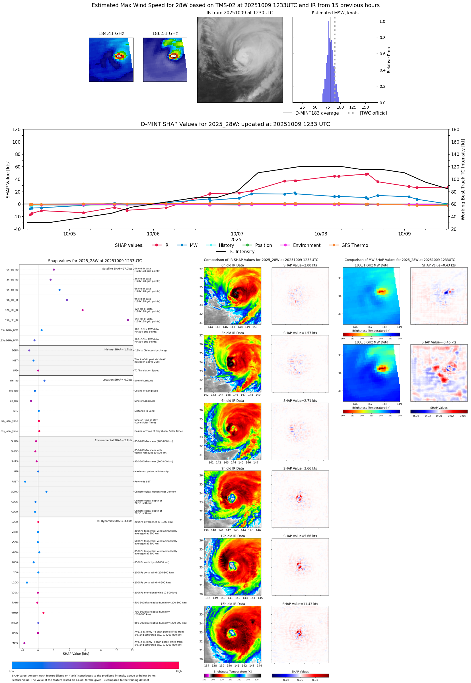 |
| 20251009 | 0621 UTC | TROPICS05 | 963 hPa | 86 kts | 81 kts | 91 kts | 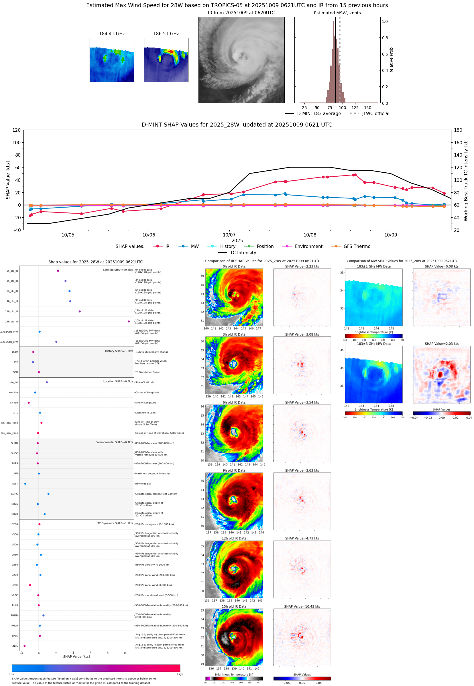 |
| 20251009 | 0533 UTC | SSMISF18 | 967 hPa | 89 kts | 83 kts | 95 kts |  |
| 20251009 | 0533 UTC | SSMISF18 | 967 hPa | 89 kts | 83 kts | 95 kts |  |
| 20251009 | 0458 UTC | TMS07 | 965 hPa | 89 kts | 83 kts | 94 kts | 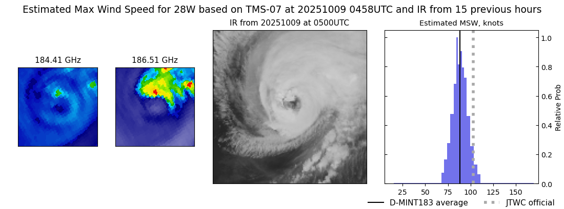 |
| 20251009 | 0444 UTC | TROPICS05 | 961 hPa | 83 kts | 79 kts | 88 kts |  |
| 20251009 | 0335 UTC | ATMS-N20 | 963 hPa | 90 kts | 85 kts | 95 kts | 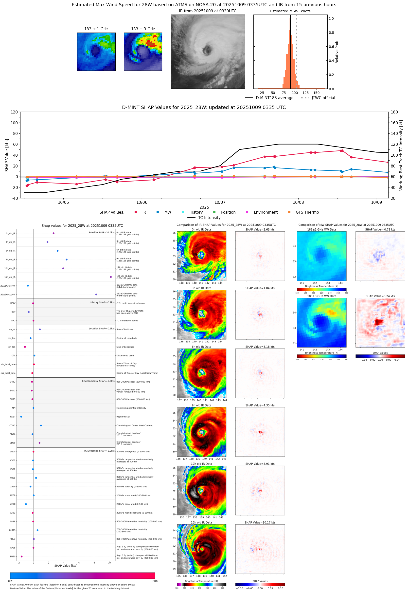 |
| 20251009 | 0314 UTC | ATMS-NPP | 961 hPa | 93 kts | 88 kts | 98 kts | 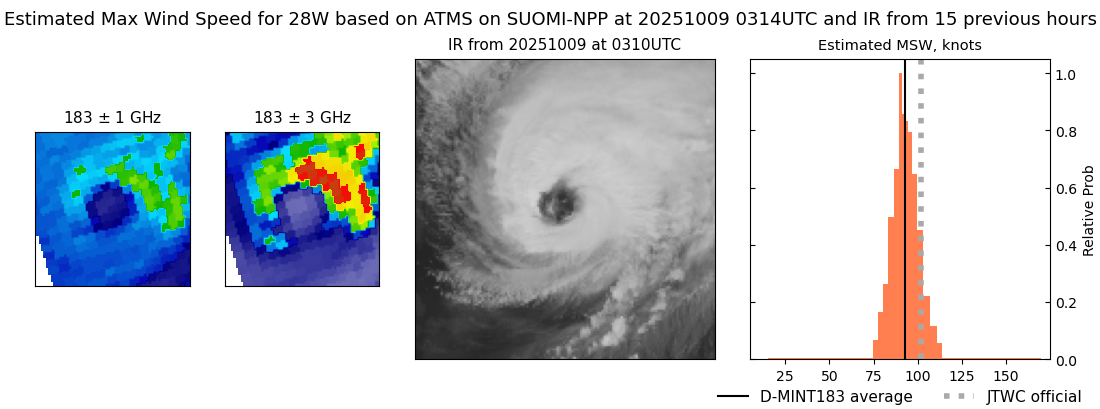 |
| 20251009 | 0116 UTC | AWS | 958 hPa | 96 kts | 91 kts | 101 kts |  |
| 20251008 | 2132 UTC | WSFM01 | 957 hPa | 101 kts | 96 kts | 107 kts | 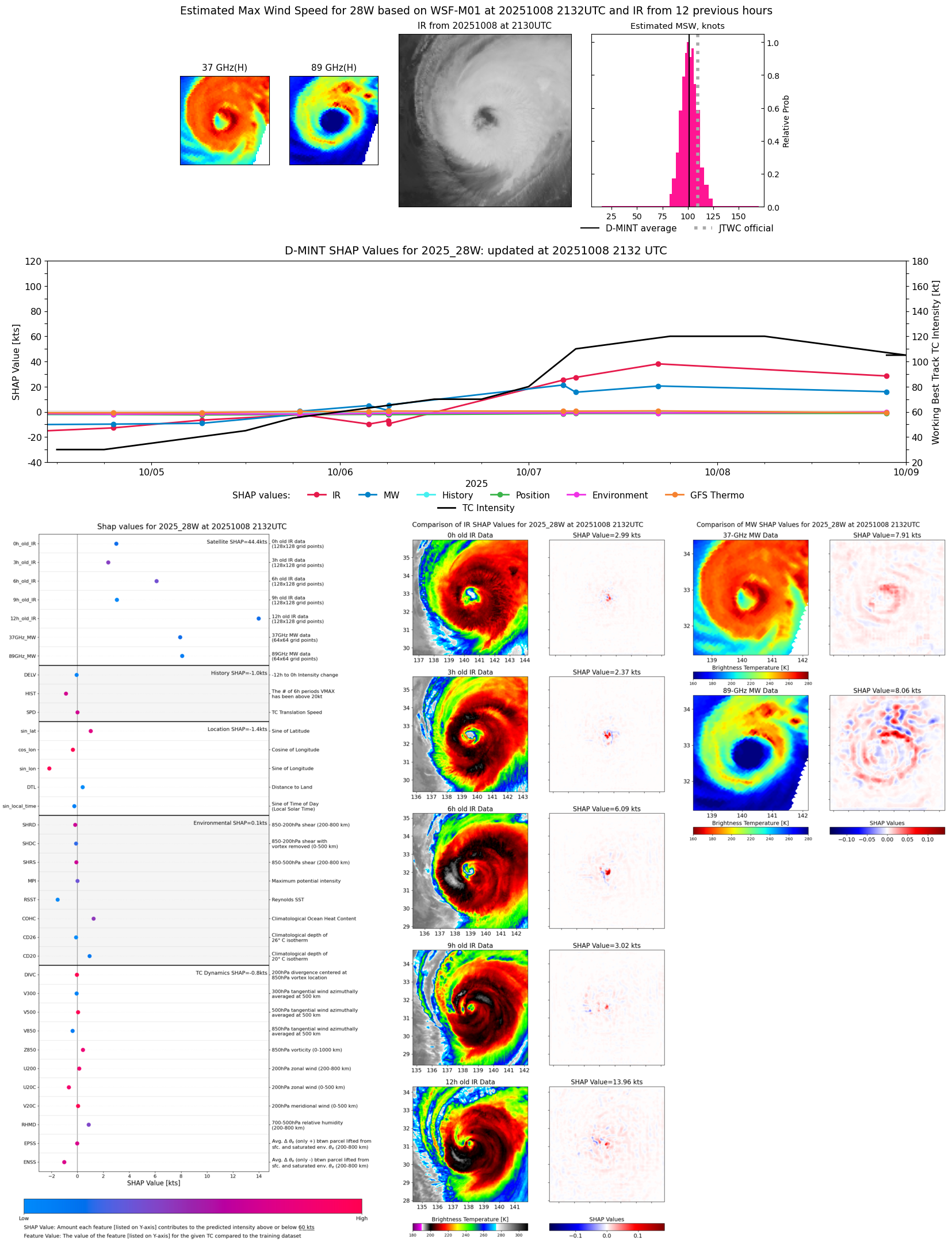 |
| 20251008 | 1900 UTC | TROPICS03 | 952 hPa | 105 kts | 100 kts | 109 kts |  |
| 20251008 | 1617 UTC | ATMS-N20 | 947 hPa | 107 kts | 102 kts | 113 kts |  |
| 20251008 | 1328 UTC | TMS06 | 939 hPa | 115 kts | 110 kts | 121 kts |  |
| 20251008 | 1258 UTC | TMS02 | 940 hPa | 117 kts | 111 kts | 122 kts | 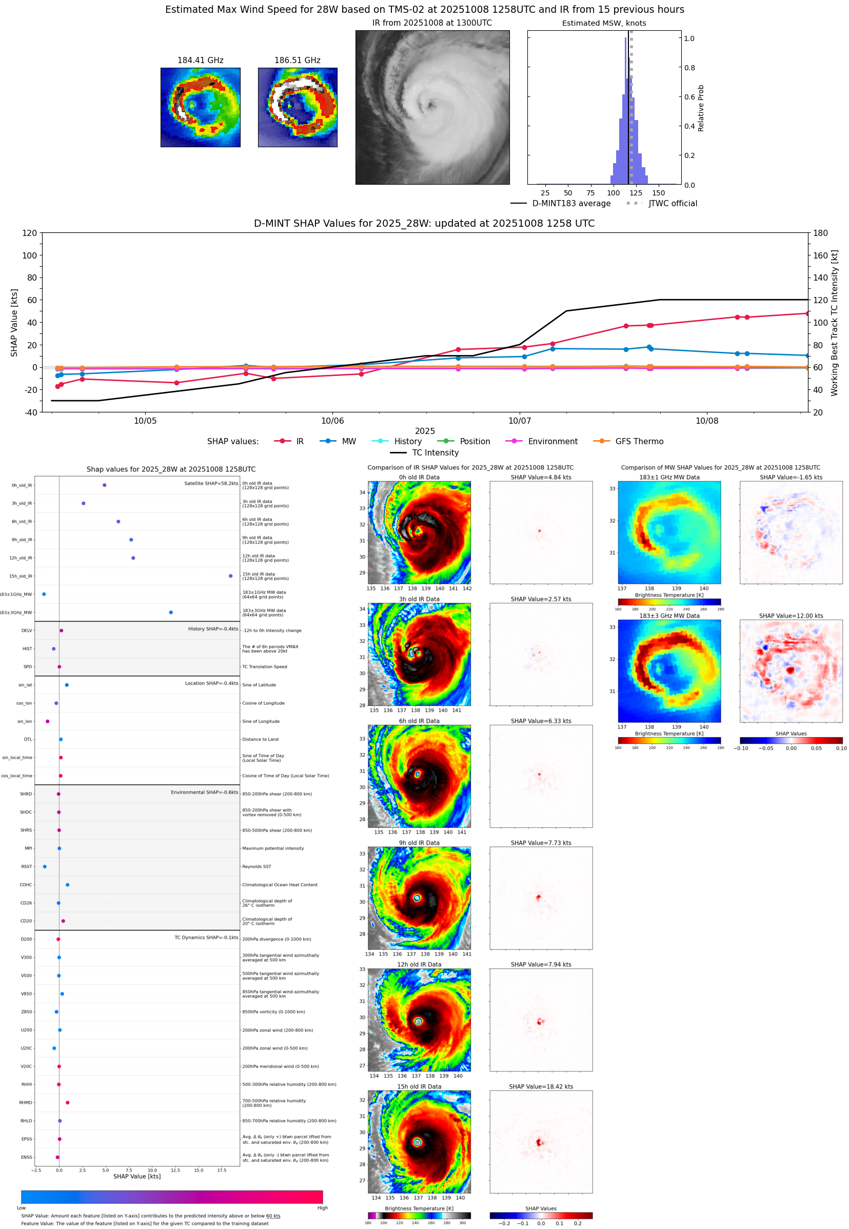 |
| 20251008 | 0510 UTC | TMS07 | 934 hPa | 115 kts | 110 kts | 120 kts | 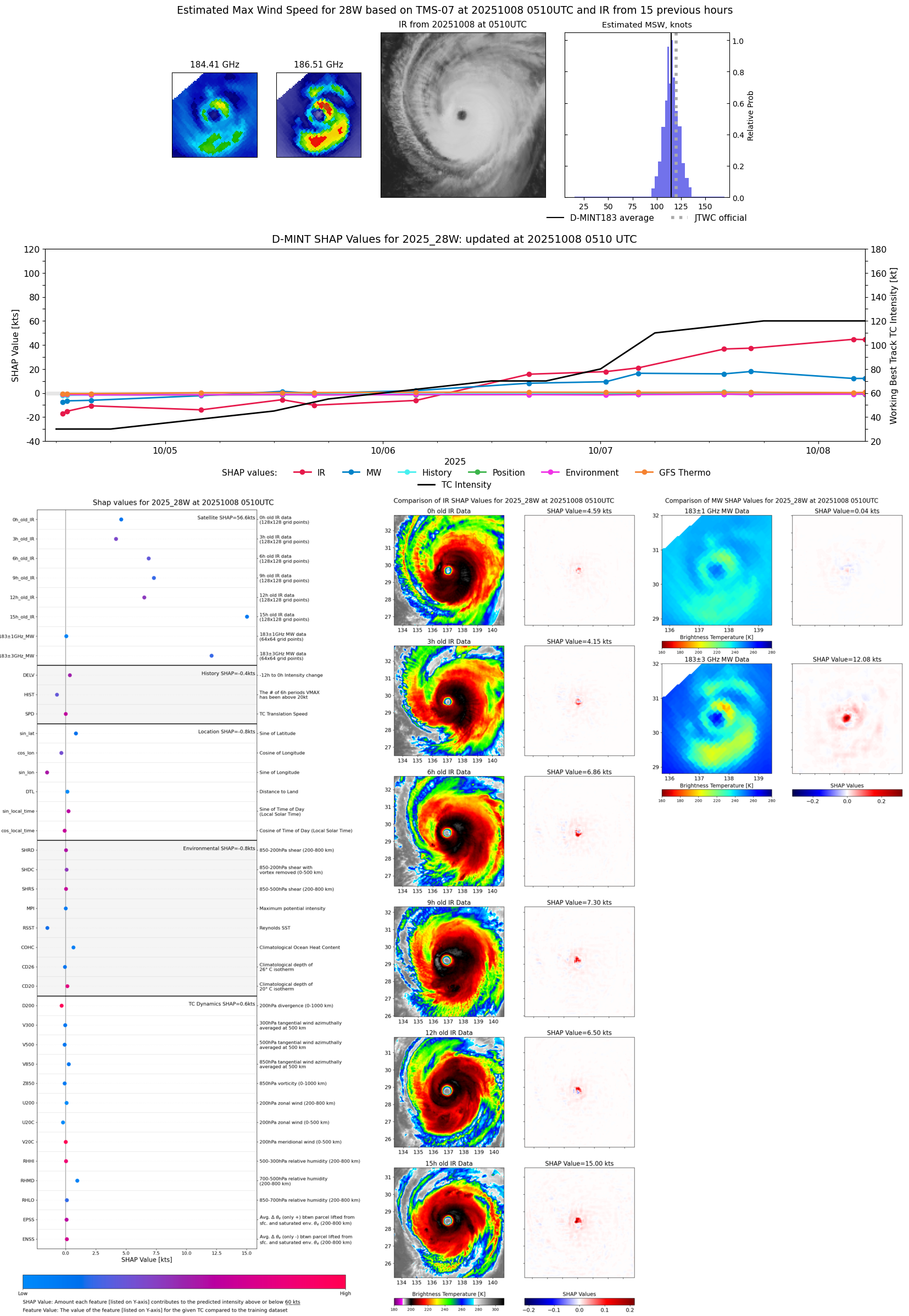 |
| 20251008 | 0353 UTC | ATMS-N20 | 936 hPa | 115 kts | 111 kts | 120 kts | 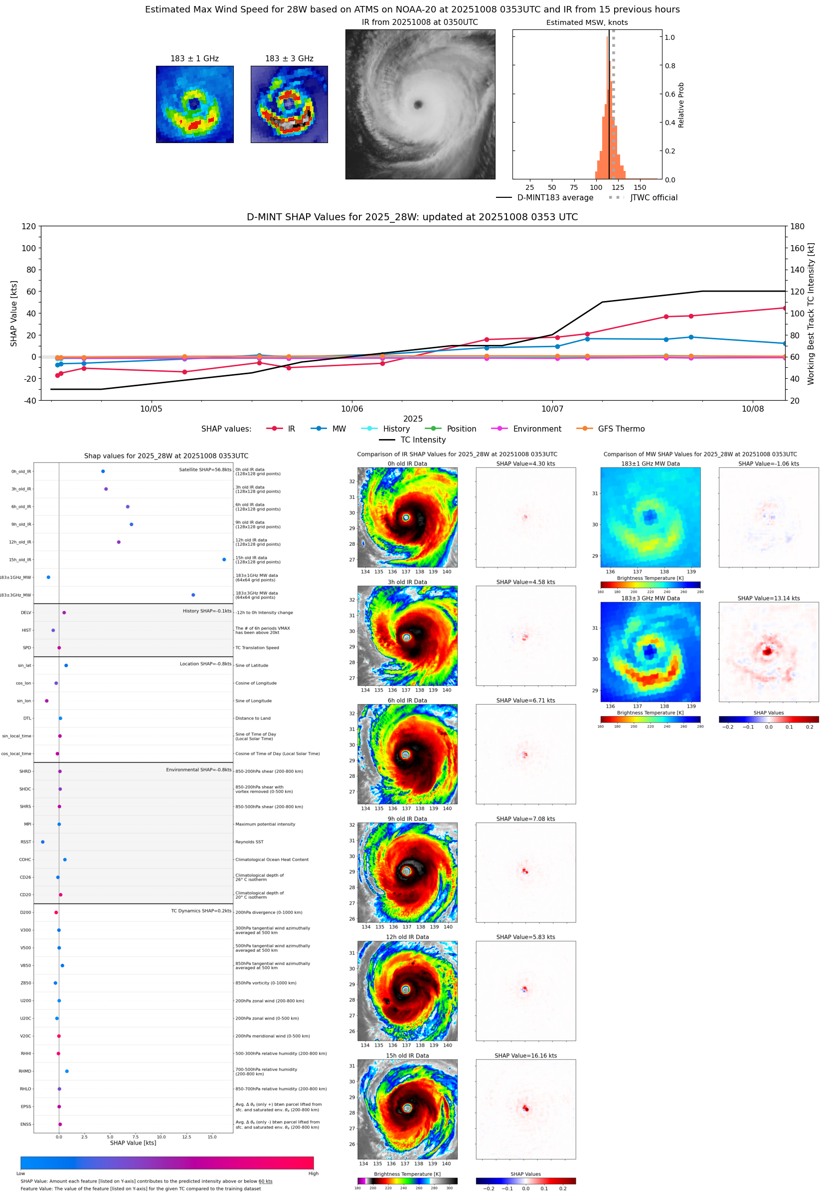 |
| 20251007 | 1650 UTC | TROPICS03 | 939 hPa | 112 kts | 108 kts | 117 kts | 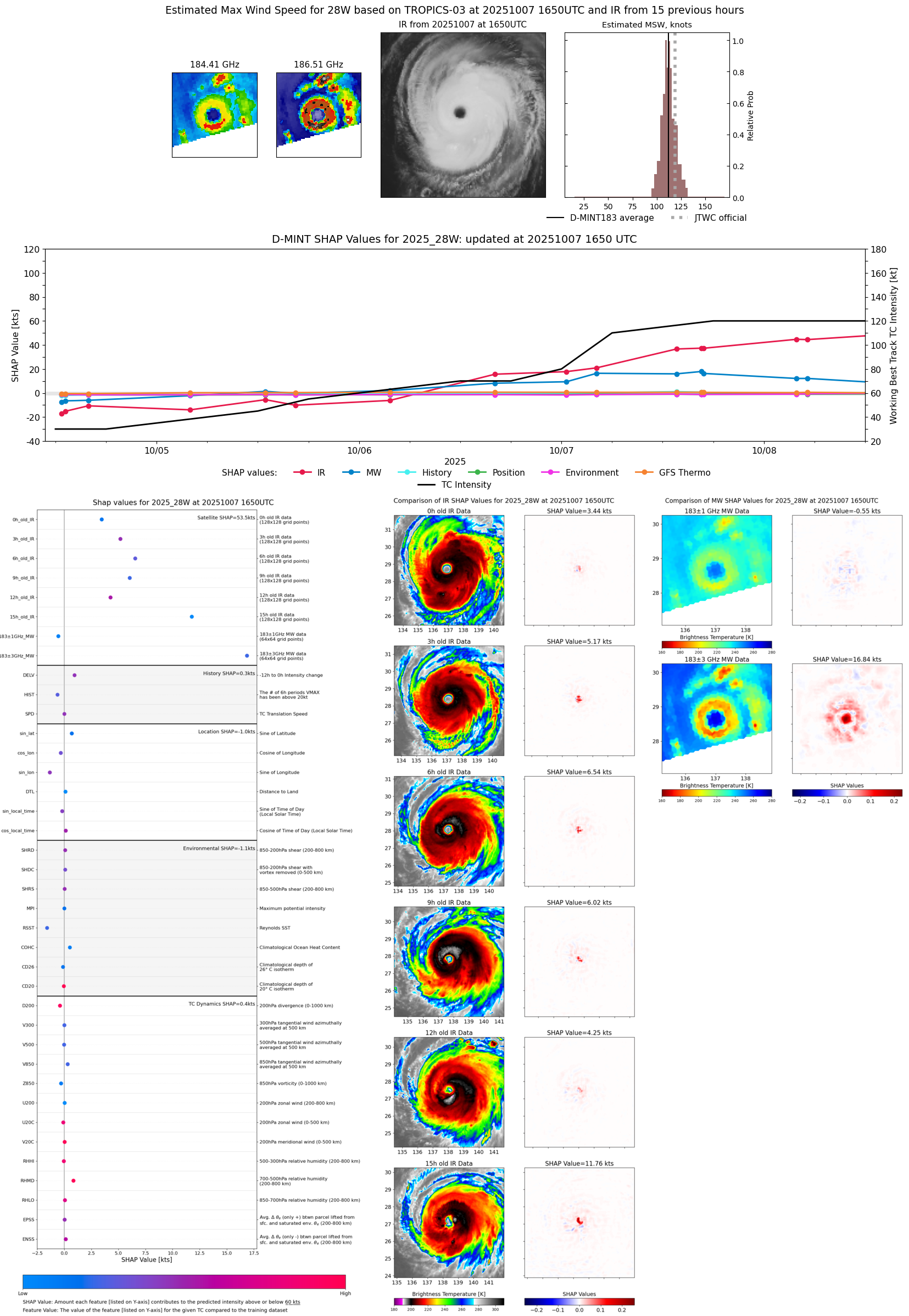 |
| 20251007 | 1636 UTC | ATMS-N20 | 941 hPa | 114 kts | 109 kts | 120 kts | 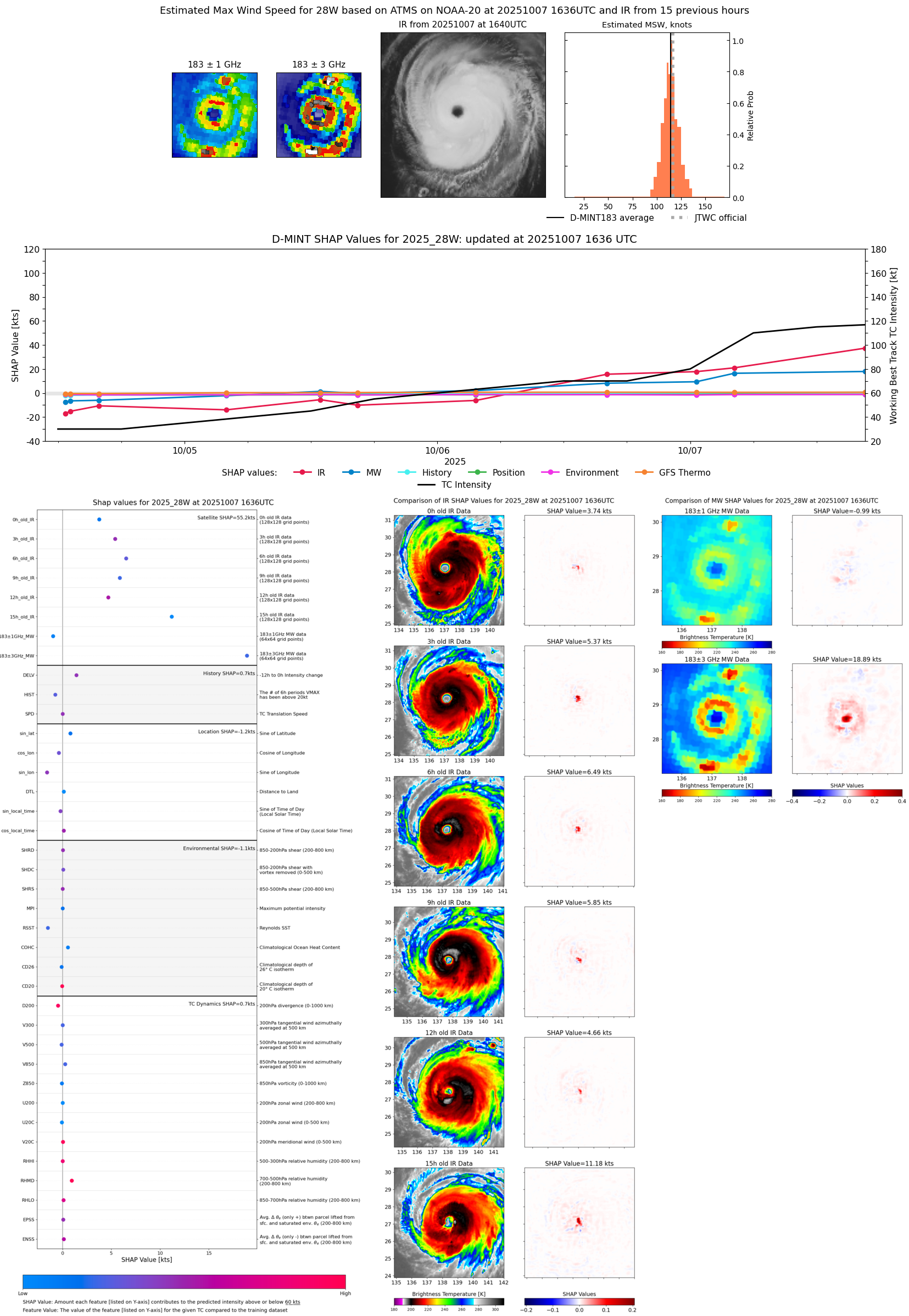 |
| 20251007 | 1630 UTC | AMSR2 | 930 hPa | 116 kts | 111 kts | 120 kts |  |
| 20251007 | 1338 UTC | TMS07 | 943 hPa | 112 kts | 107 kts | 118 kts |  |
| 20251007 | 0600 UTC | SSMISF18 | 951 hPa | 100 kts | 95 kts | 106 kts | 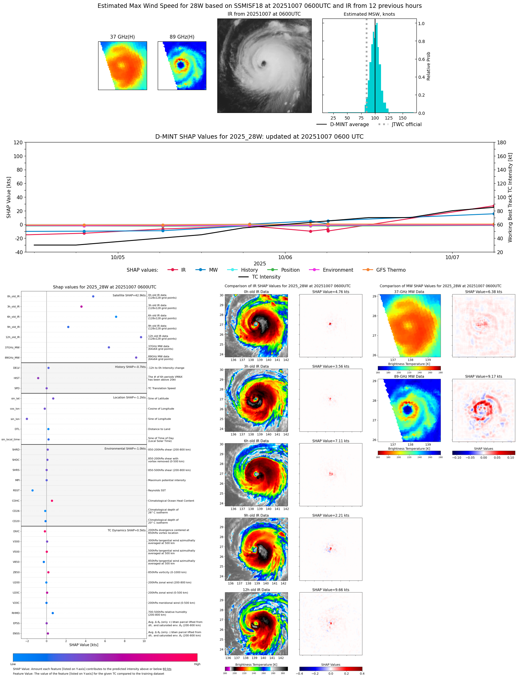 |
| 20251007 | 0424 UTC | AMSR2 | 957 hPa | 104 kts | 98 kts | 109 kts |  |
| 20251007 | 0411 UTC | ATMS-N20 | 953 hPa | 96 kts | 91 kts | 101 kts | 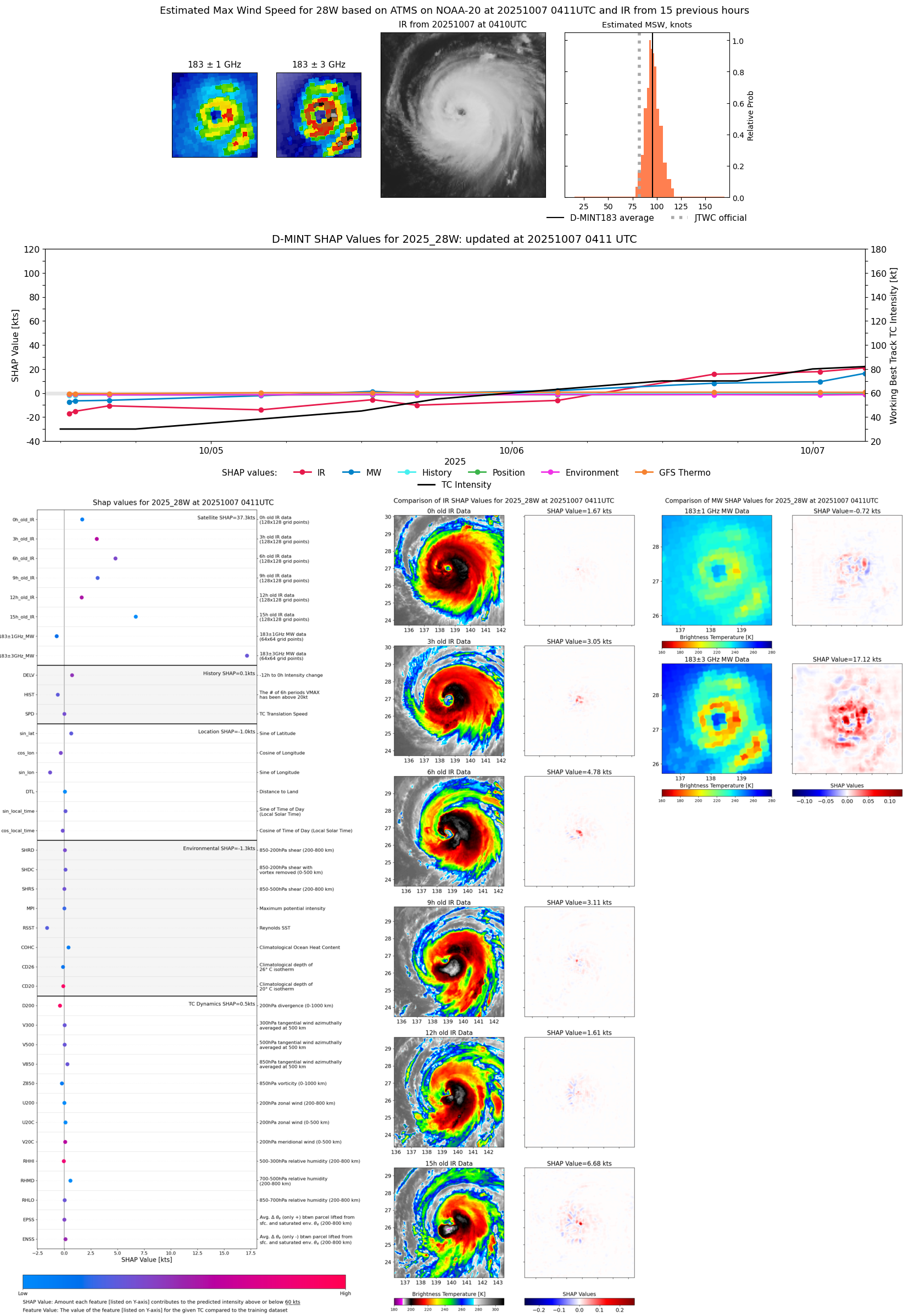 |
| 20251007 | 0035 UTC | TMS06 | 961 hPa | 85 kts | 80 kts | 90 kts | 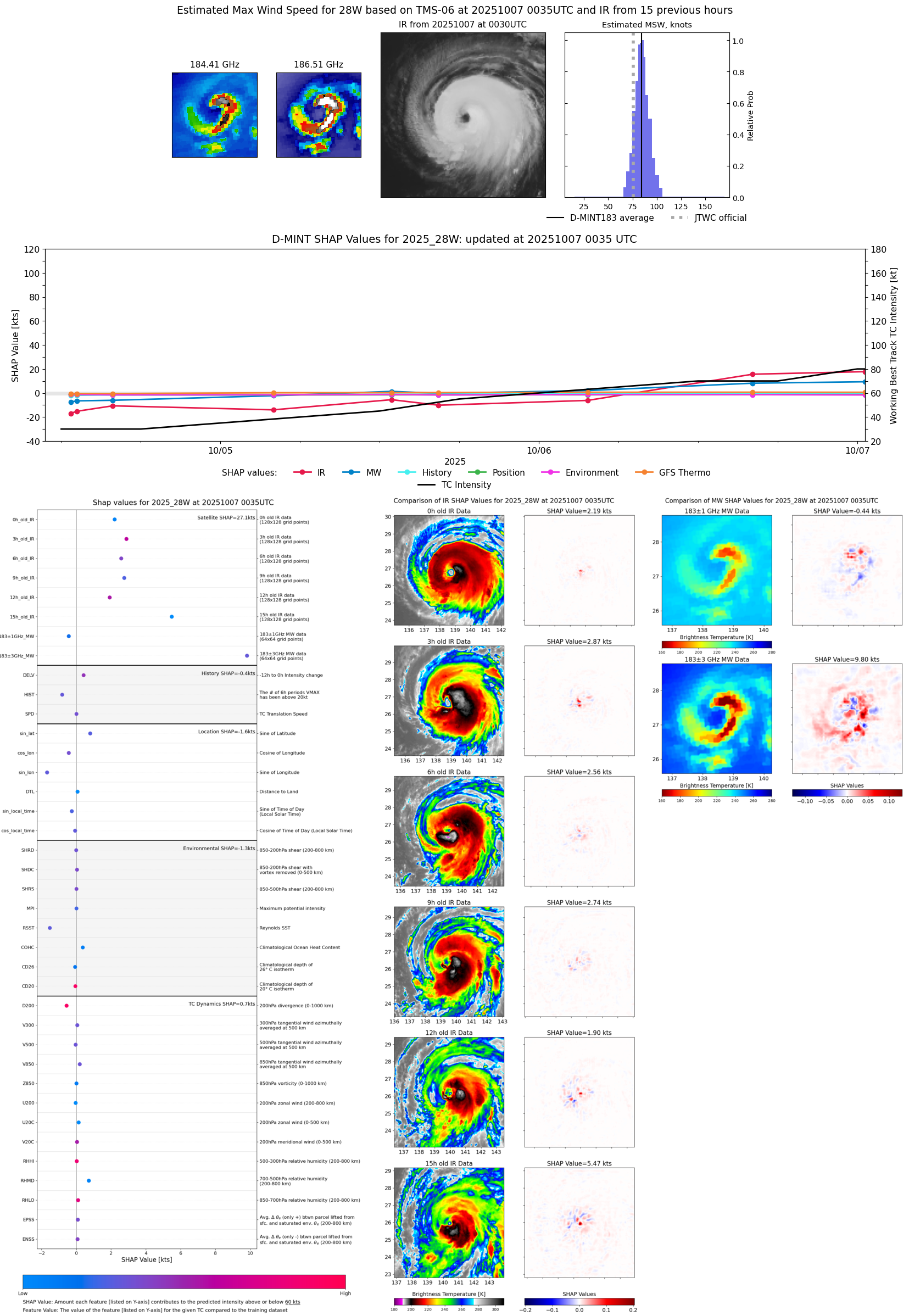 |
| 20251006 | 1933 UTC | GMI | 966 hPa | 75 kts | 69 kts | 80 kts |  |
| 20251006 | 1841 UTC | SSMISF18 | 968 hPa | 78 kts | 72 kts | 84 kts | 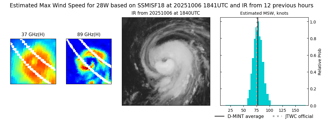 |
| 20251006 | 1607 UTC | ATMS-N21 | 974 hPa | 81 kts | 75 kts | 88 kts |  |
| 20251006 | 1326 UTC | TMS05 | 979 hPa | 62 kts | 56 kts | 69 kts | 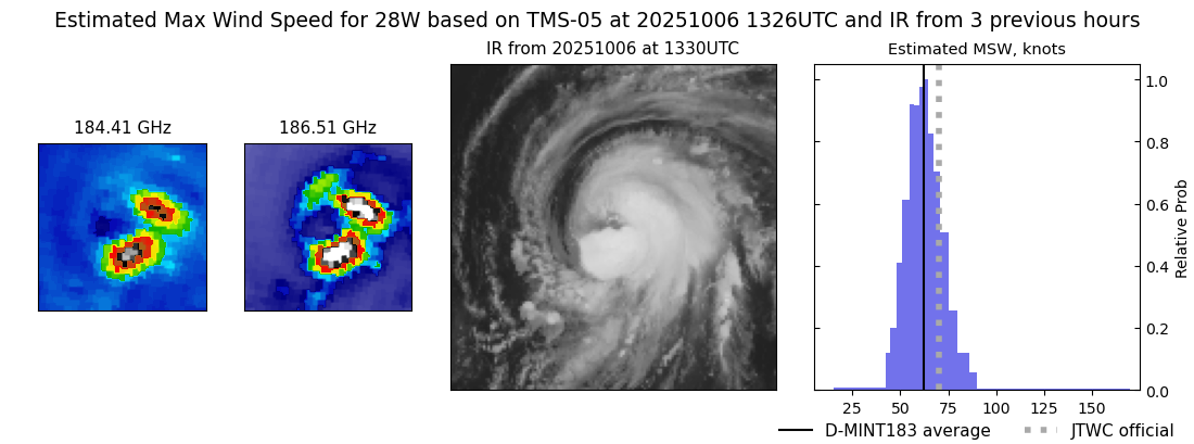 |
| 20251006 | 0612 UTC | SSMISF18 | 986 hPa | 52 kts | 47 kts | 58 kts |  |
| 20251006 | 0608 UTC | GMI | 987 hPa | 50 kts | 45 kts | 56 kts |  |
| 20251006 | 0340 UTC | AMSR2 | 988 hPa | 53 kts | 49 kts | 58 kts |  |
| 20251006 | 0340 UTC | ATMS-N21 | 988 hPa | 53 kts | 49 kts | 58 kts | 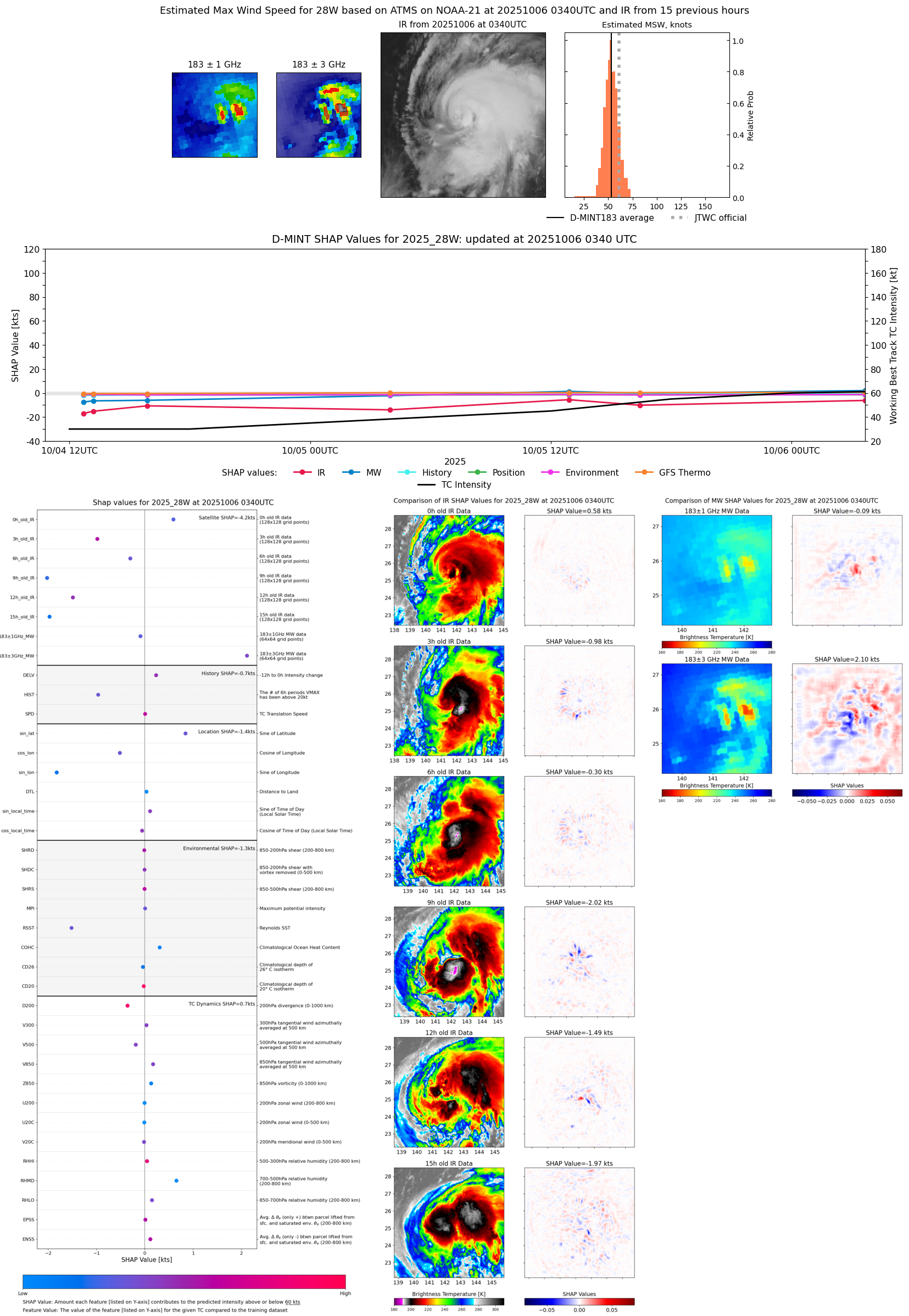 |
| 20251005 | 1855 UTC | SSMISF18 | 991 hPa | 53 kts | 48 kts | 58 kts | 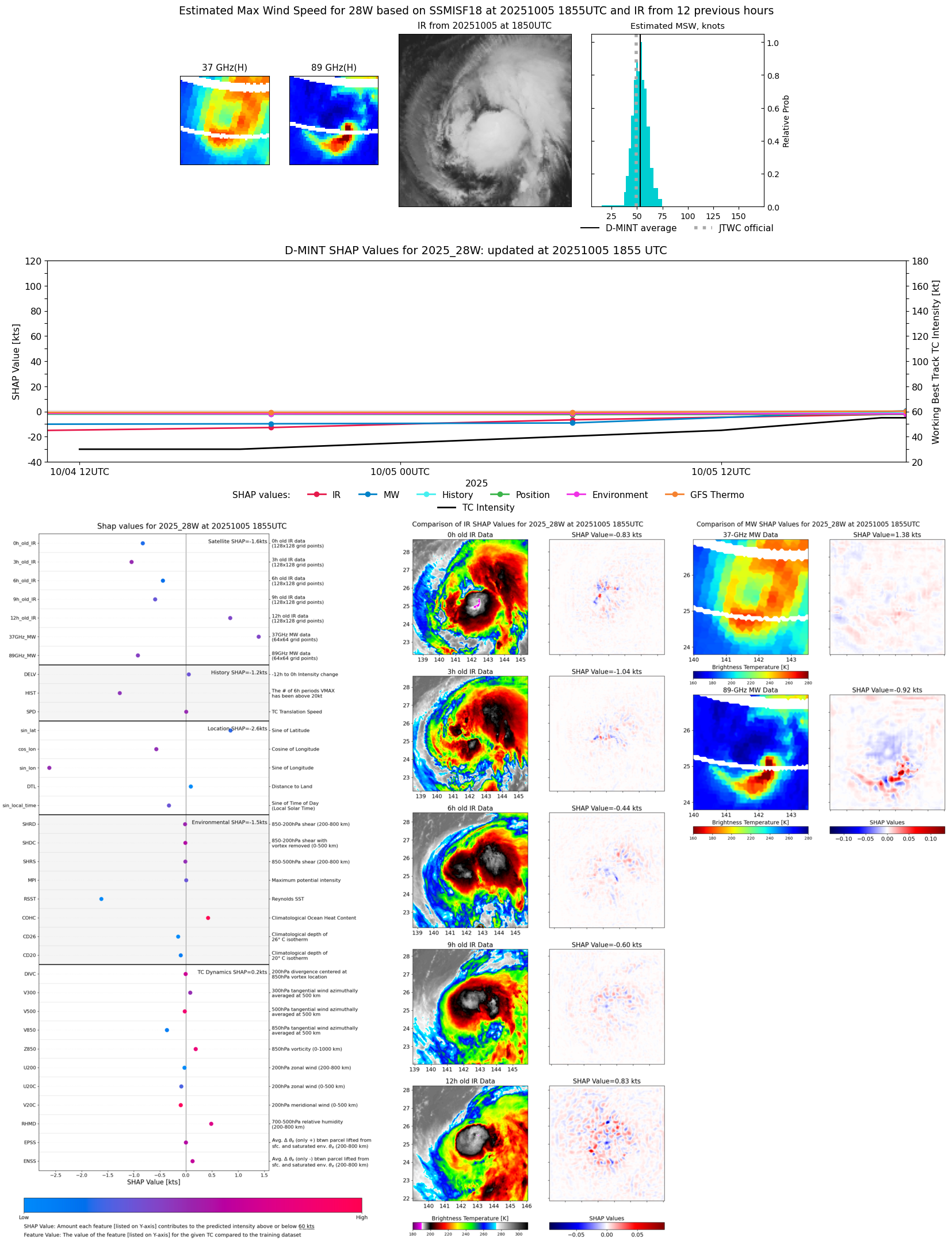 |
| 20251005 | 1854 UTC | SSMISF18 | 990 hPa | 51 kts | 46 kts | 56 kts |  |
| 20251005 | 1643 UTC | AMSR2 | 988 hPa | 54 kts | 49 kts | 59 kts | 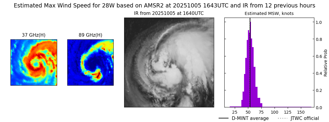 |
| 20251005 | 1626 UTC | ATMS-N21 | 989 hPa | 46 kts | 41 kts | 51 kts | 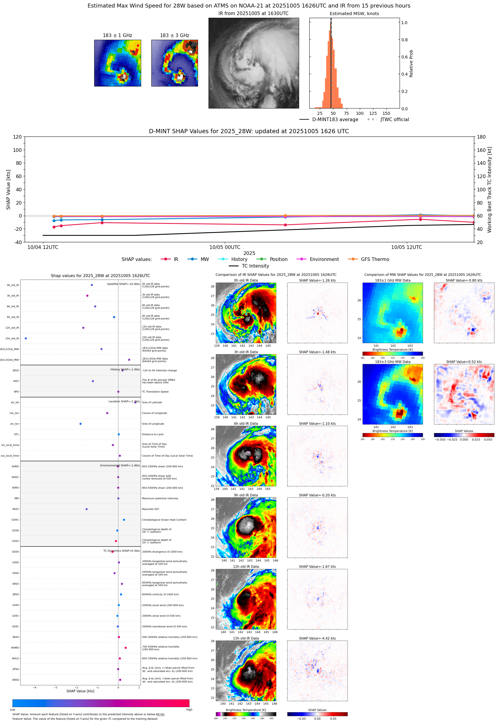 |
| 20251005 | 1254 UTC | AWS | 991 hPa | 52 kts | 47 kts | 58 kts | 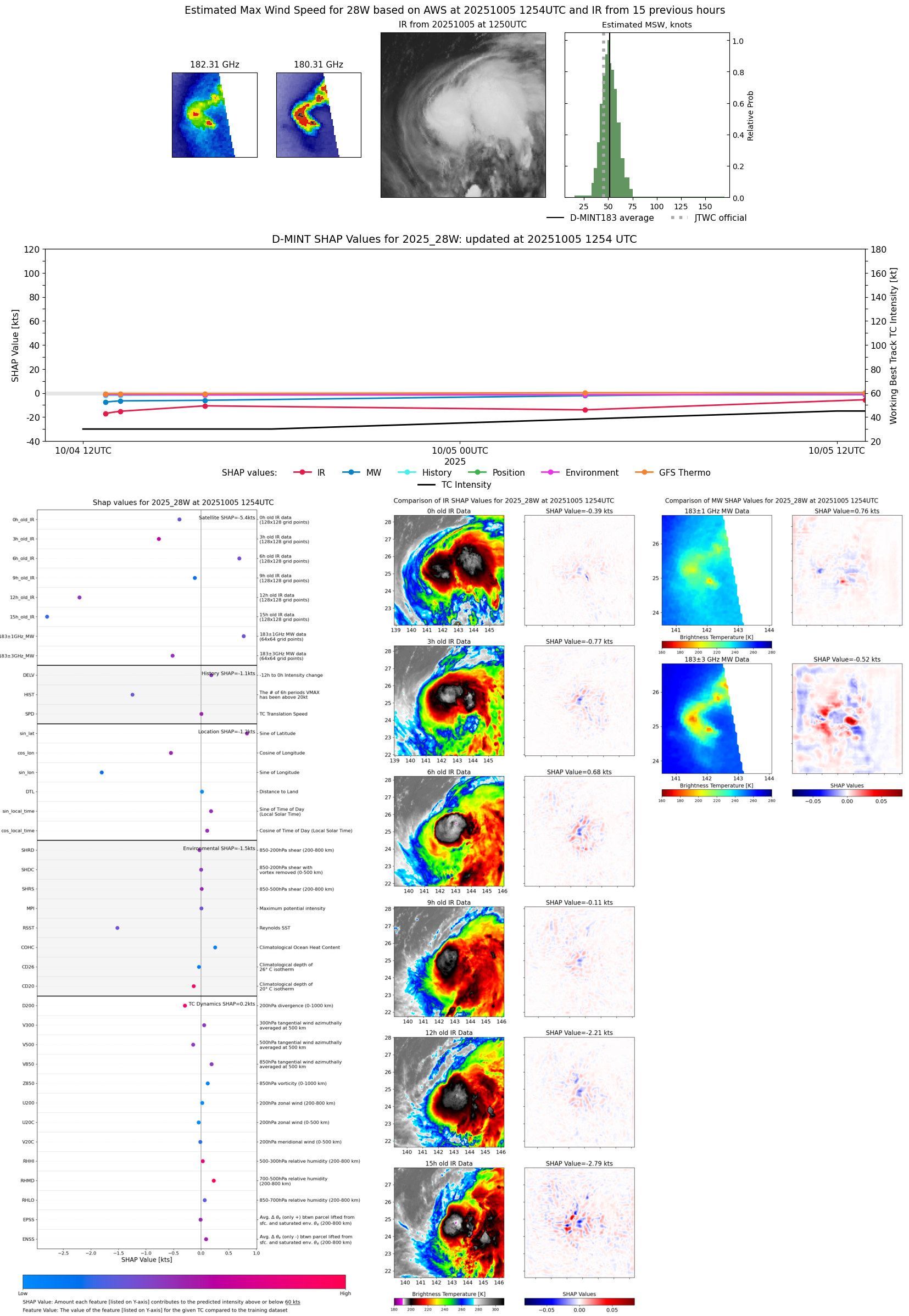 |
| 20251005 | 1254 UTC | TMS02 | 991 hPa | 52 kts | 47 kts | 58 kts |  |
| 20251005 | 0626 UTC | SSMISF18 | 1001 hPa | 39 kts | 35 kts | 43 kts |  |
| 20251005 | 0626 UTC | SSMISF18 | 1001 hPa | 39 kts | 35 kts | 43 kts | 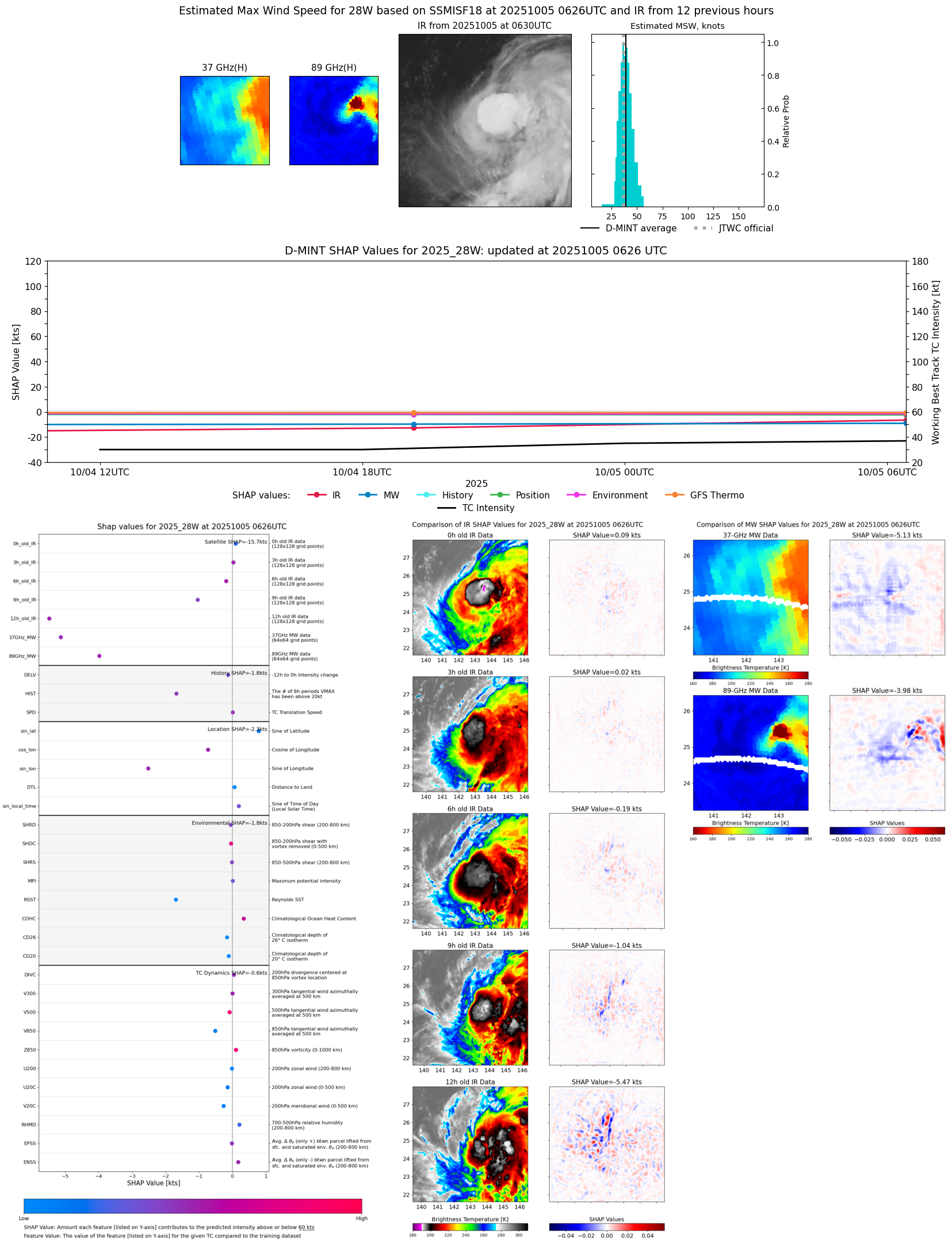 |
| 20251005 | 0359 UTC | ATMS-N21 | 1002 hPa | 39 kts | 35 kts | 44 kts | 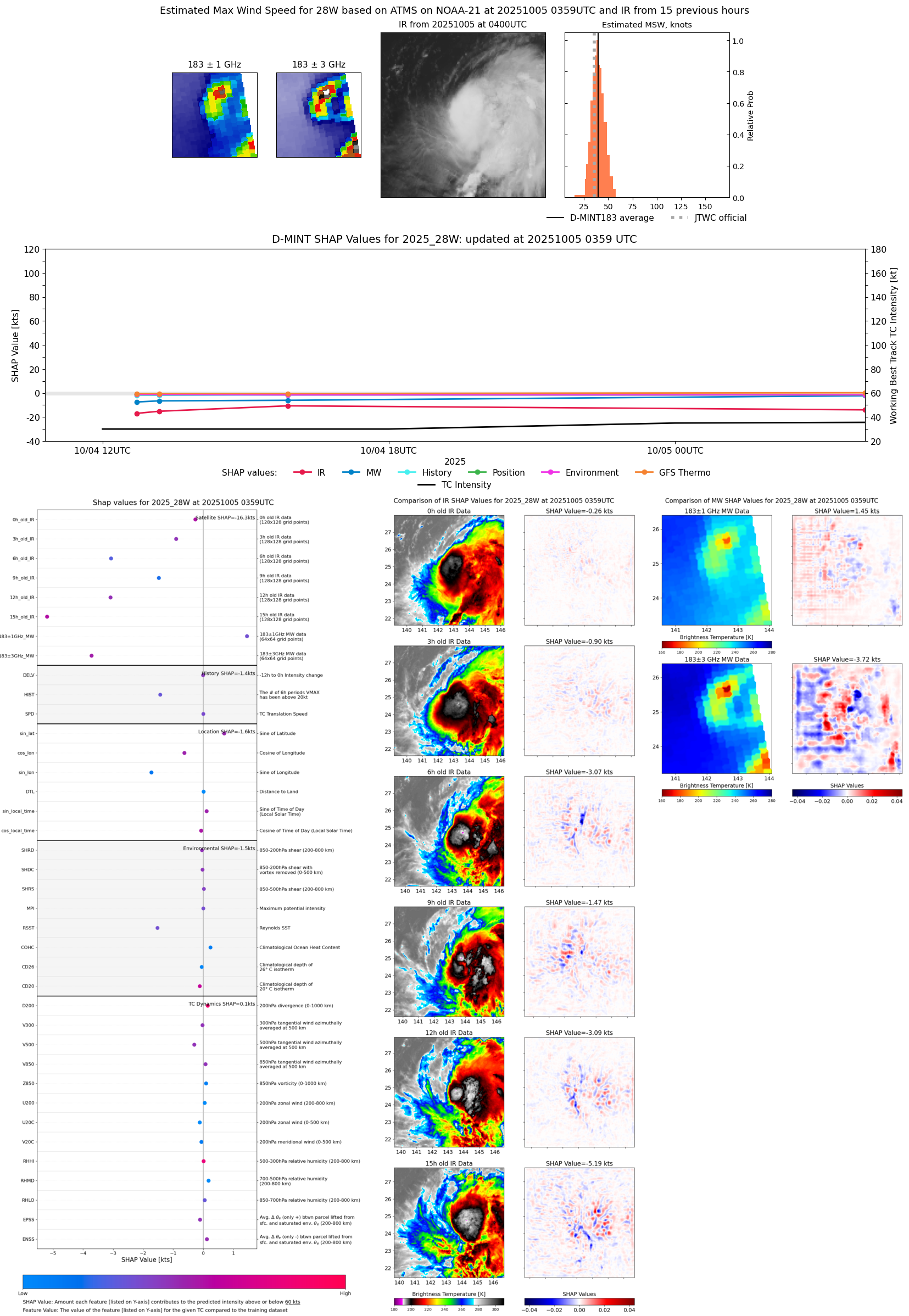 |
| 20251004 | 0352 UTC | AMSR2 | NaN hPa | 25 kts | 21 kts | 28 kts | 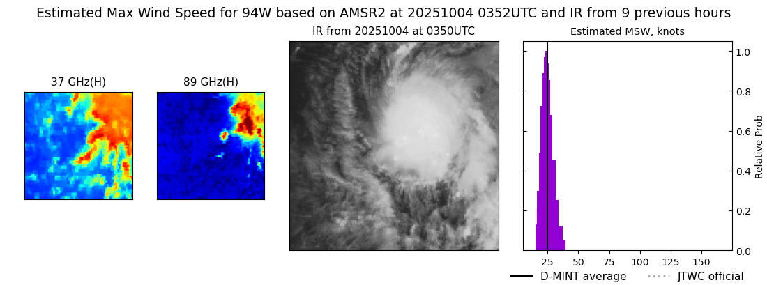 |
| 20251004 | 1910 UTC | SSMISF18 | 1002 hPa | 30 kts | 27 kts | 34 kts |  |
| 20251004 | 1910 UTC | SSMISF18 | 1002 hPa | 30 kts | 27 kts | 34 kts |  |
| 20251004 | 1600 UTC | AMSR2 | 1002 hPa | 31 kts | 27 kts | 34 kts | 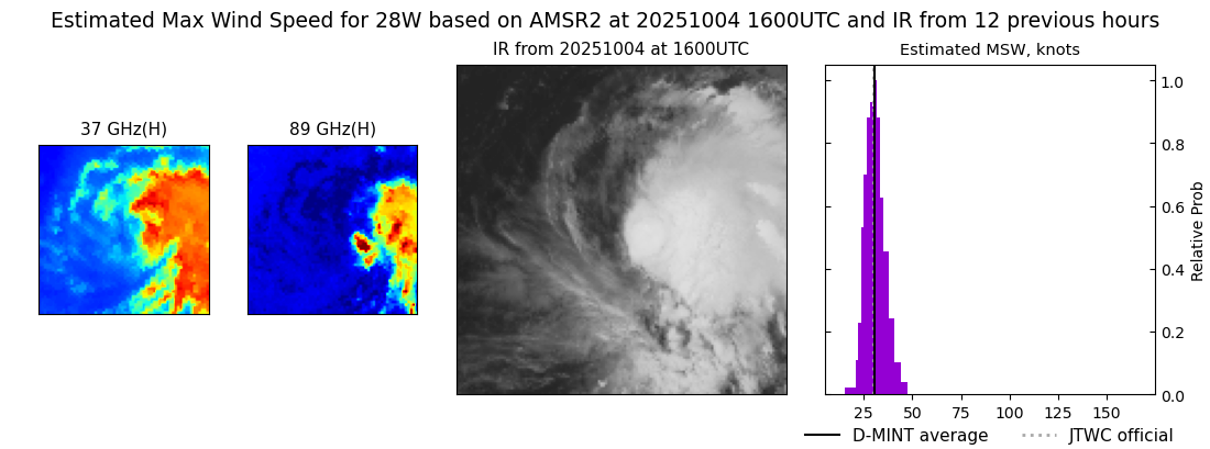 |
| 20251004 | 1553 UTC | ATMS-N20 | 1003 hPa | 38 kts | 34 kts | 43 kts | 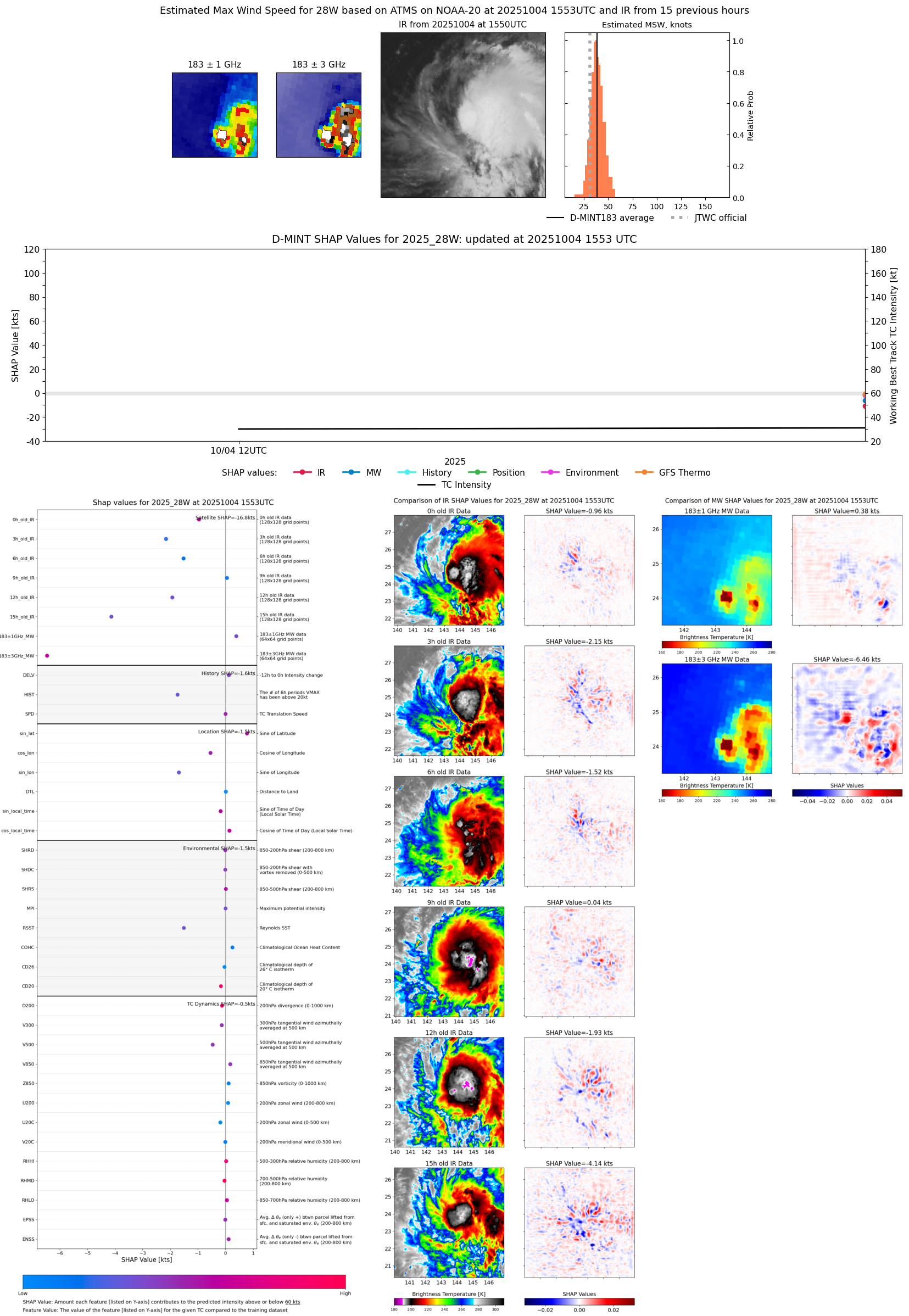 |
| 20251004 | 1311 UTC | TMS06 | 1003 hPa | 33 kts | 30 kts | 38 kts | 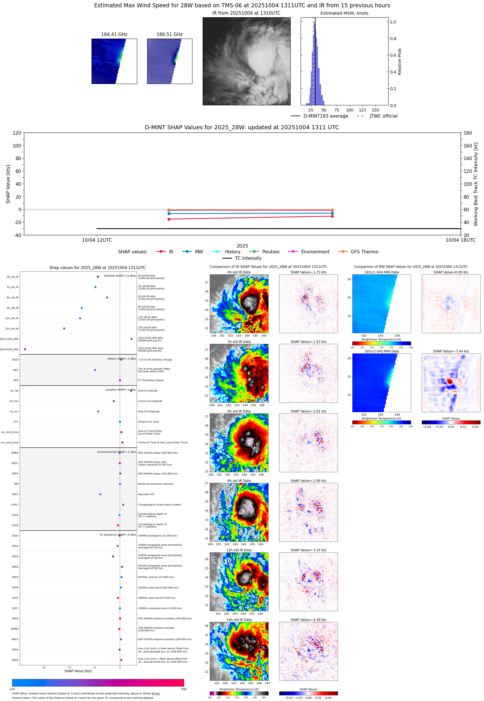 |
| 20251004 | 1243 UTC | AWS | 1003 hPa | 31 kts | 28 kts | 34 kts | 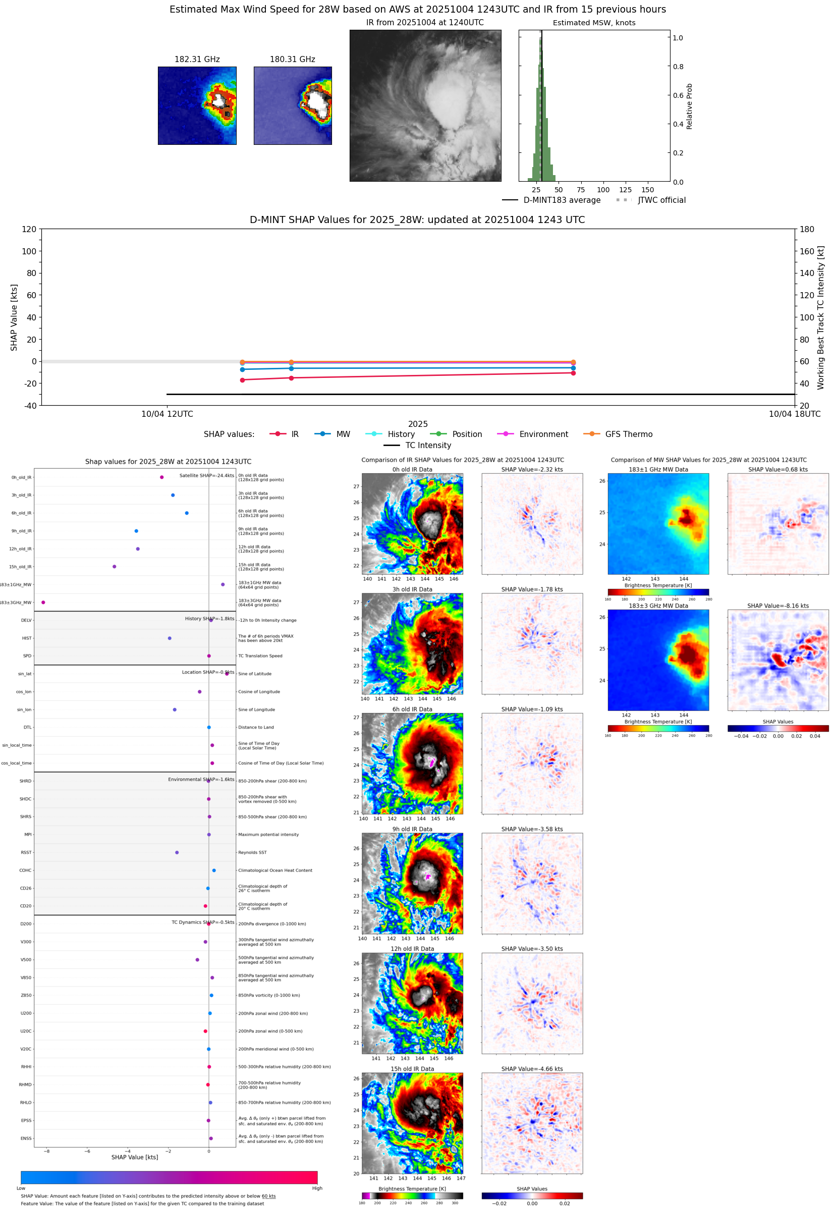 |
| 20251004 | 0640 UTC | SSMISF18 | 1005 hPa | 26 kts | 23 kts | 29 kts | 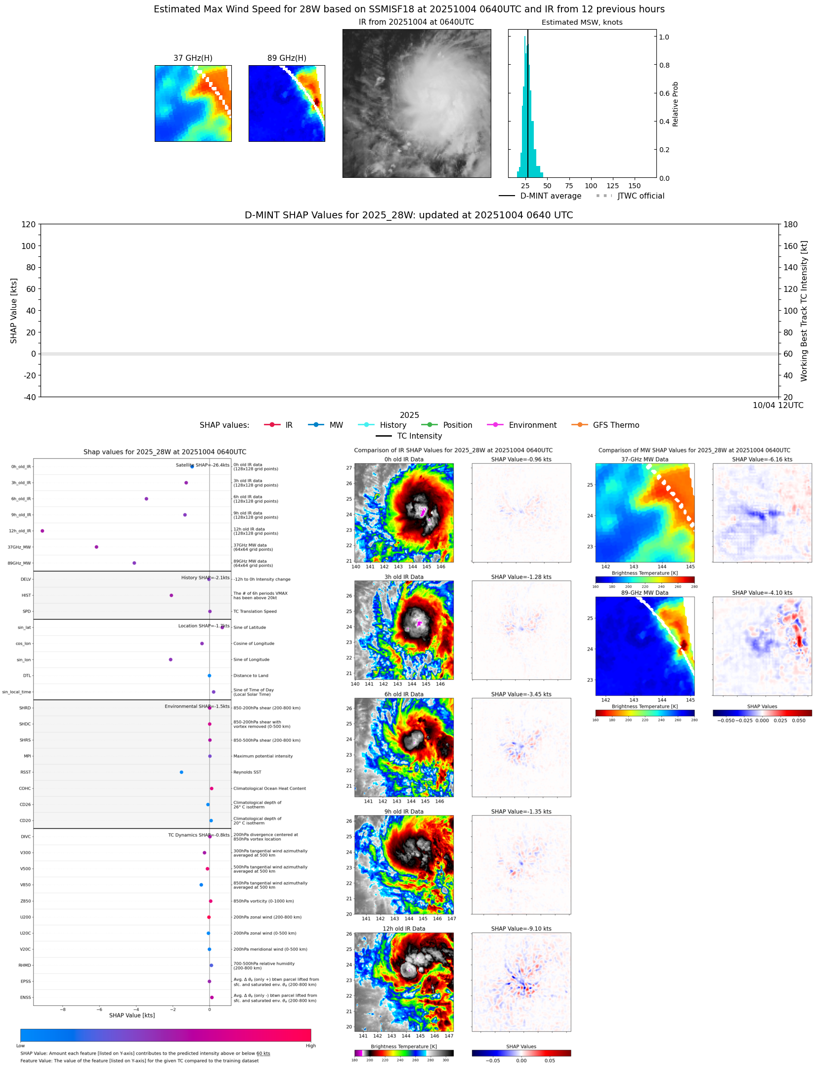 |
| 20251004 | 0640 UTC | SSMISF18 | 1005 hPa | 26 kts | 23 kts | 29 kts |  |
| 20251003 | 2008 UTC | GMI | NaN hPa | 20 kts | 17 kts | 23 kts | 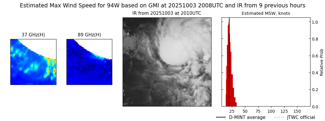 |
| 20251003 | 0308 UTC | AMSR2 | NaN hPa | 15 kts | 14 kts | 17 kts | 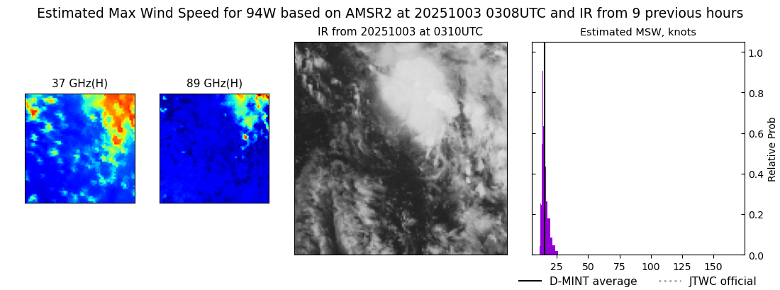 |
| 20251002 | 1615 UTC | AMSR2 | NaN hPa | 15 kts | 14 kts | 17 kts | 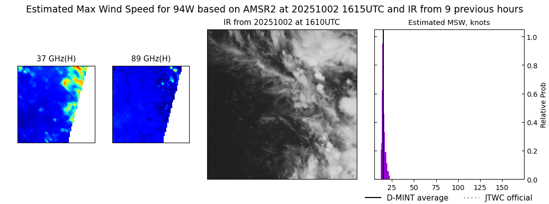 |