|
||

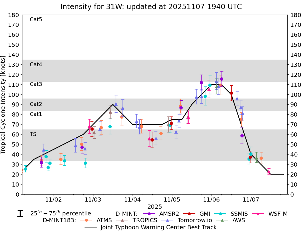 |
D-MINT HISTORY FILE for 2025_31W
| Date | Time | MW Sensor | MSLP | Vmax (30th-70th percentile average) | Vmax 25th percentile | Vmax 75th percentile | Image |
| 20251107 | 1049 UTC | WSFM01 | 999 hPa | 23 kts | 20 kts | 26 kts | 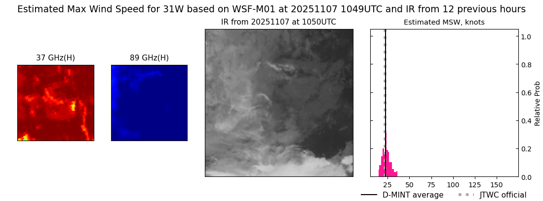 |
| 20251107 | 0609 UTC | ATMS-N20 | 998 hPa | 36 kts | 31 kts | 42 kts | 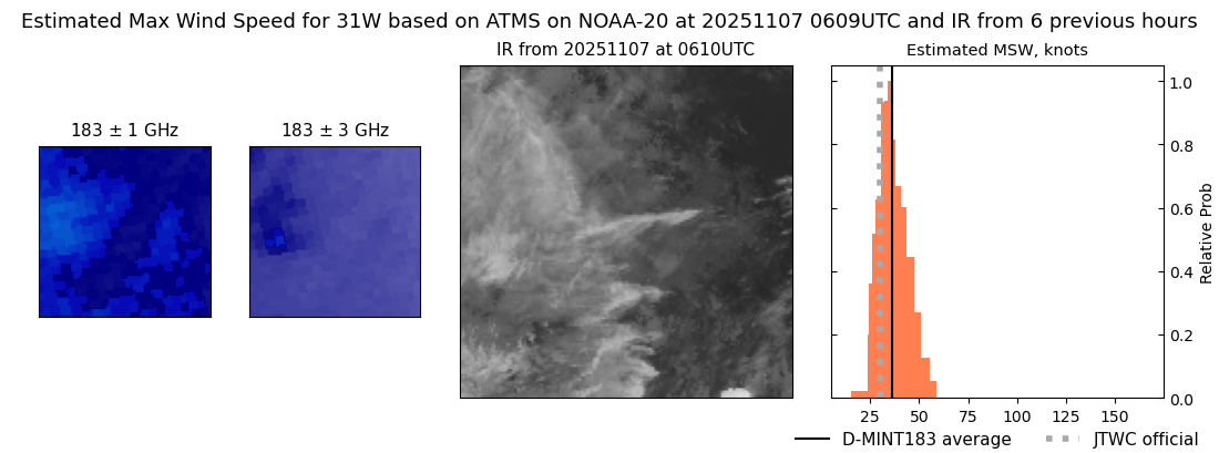 |
| 20251107 | 0319 UTC | AWS | 997 hPa | 37 kts | 32 kts | 42 kts | 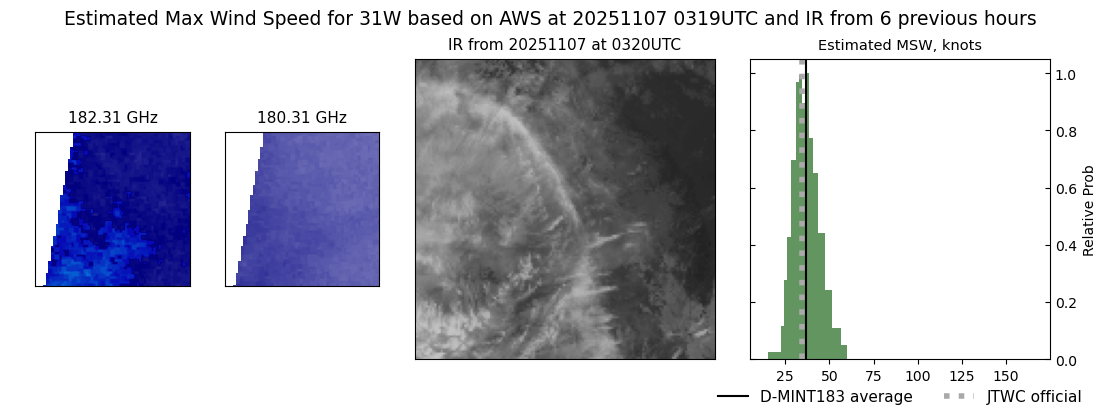 |
| 20251106 | 2352 UTC | SSMISF16 | 995 hPa | 41 kts | 35 kts | 47 kts |  |
| 20251106 | 2333 UTC | GMI | 995 hPa | 37 kts | 32 kts | 43 kts |  |
| 20251106 | 2246 UTC | SSMISF17 | 995 hPa | 35 kts | 30 kts | 41 kts |  |
| 20251106 | 1848 UTC | TMS03 | 961 hPa | 81 kts | 74 kts | 88 kts | 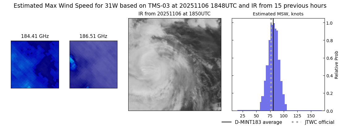 |
| 20251106 | 1825 UTC | AMSR2 | 983 hPa | 59 kts | 51 kts | 67 kts |  |
| 20251106 | 1810 UTC | ATMS-N21 | 963 hPa | 75 kts | 68 kts | 82 kts | 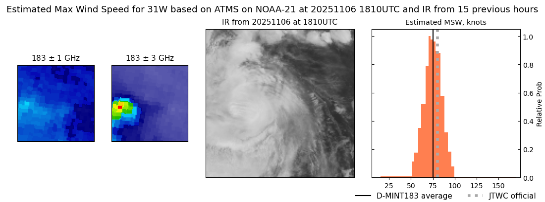 |
| 20251106 | 1747 UTC | TMS07 | 956 hPa | 87 kts | 80 kts | 94 kts |  |
| 20251106 | 1530 UTC | TMS05 | 957 hPa | 96 kts | 89 kts | 103 kts | 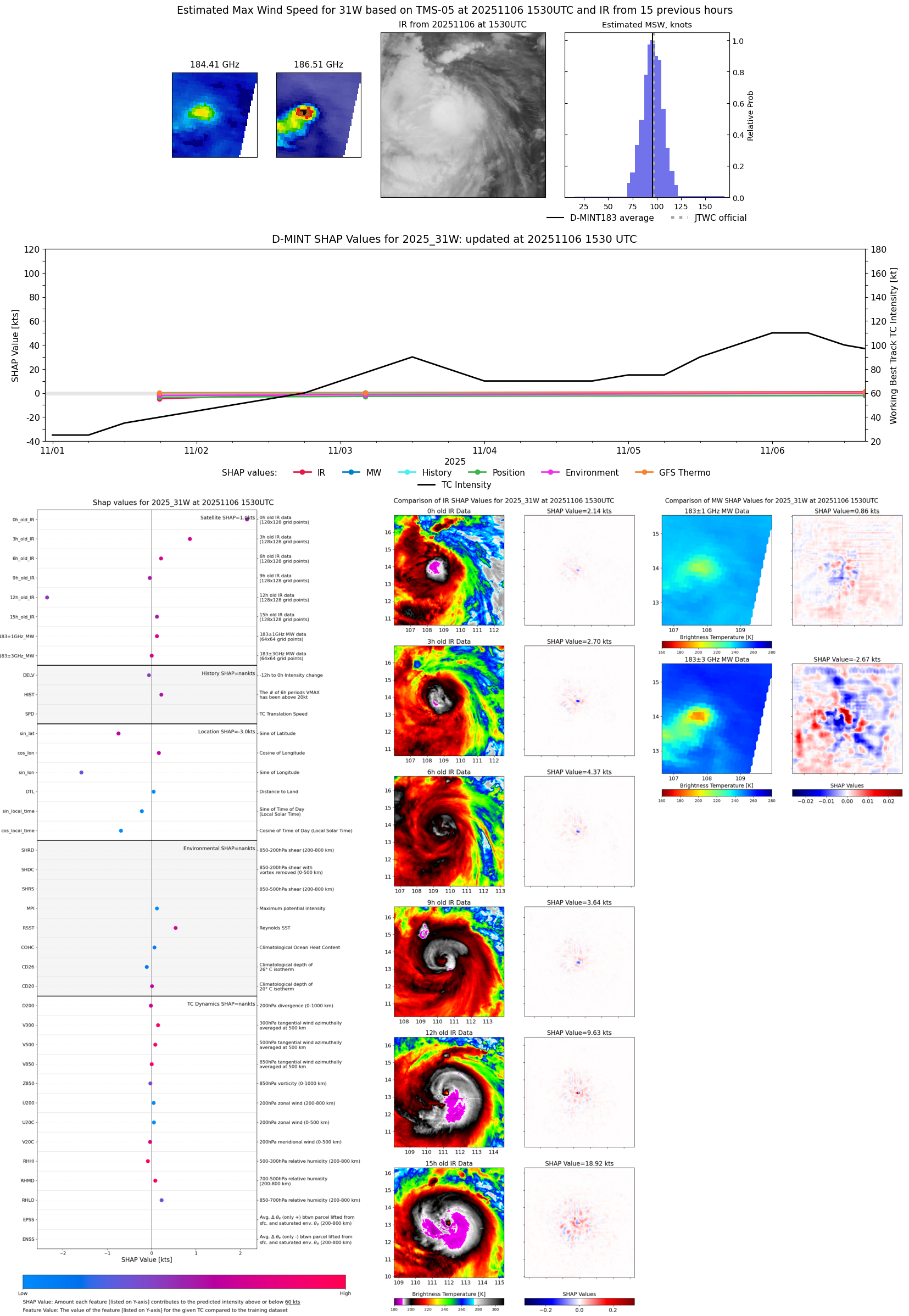 |
| 20251106 | 1203 UTC | GMI | 955 hPa | 101 kts | 94 kts | 109 kts |  |
| 20251106 | 0611 UTC | AMSR2 | 938 hPa | 116 kts | 108 kts | 123 kts |  |
| 20251106 | 0537 UTC | ATMS-N21 | 946 hPa | 110 kts | 100 kts | 119 kts |  |
| 20251106 | 0414 UTC | TMS07 | 948 hPa | 108 kts | 100 kts | 116 kts |  |
| 20251106 | 0309 UTC | AWS | 942 hPa | 108 kts | 101 kts | 116 kts | 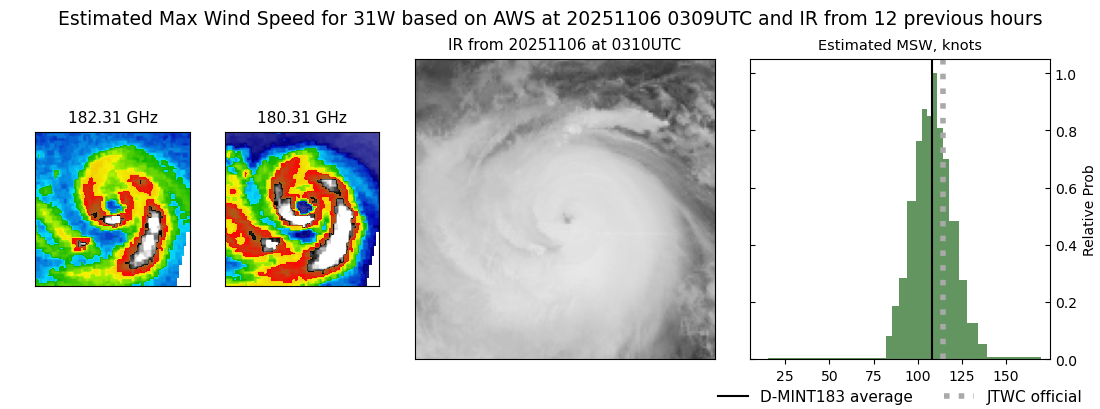 |
| 20251106 | 0254 UTC | TMS06 | 938 hPa | 114 kts | 105 kts | 122 kts |  |
| 20251105 | 2300 UTC | SSMISF17 | 939 hPa | 110 kts | 101 kts | 119 kts |  |
| 20251105 | 2221 UTC | WSFM01 | 939 hPa | 105 kts | 97 kts | 114 kts | 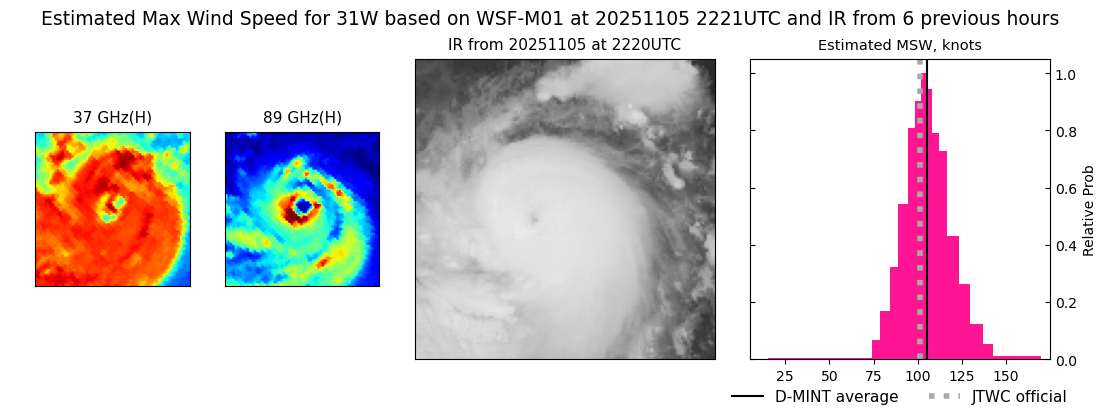 |
| 20251105 | 2009 UTC | SSMISF18 | 948 hPa | 98 kts | 89 kts | 108 kts |  |
| 20251105 | 1752 UTC | TMS07 | 953 hPa | 98 kts | 91 kts | 105 kts | 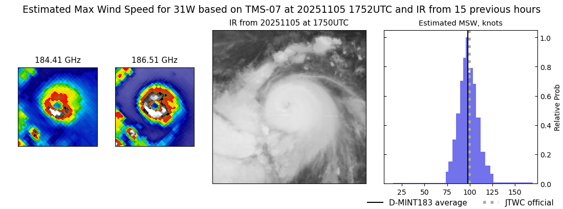 |
| 20251105 | 1743 UTC | AMSR2 | 941 hPa | 112 kts | 104 kts | 120 kts | 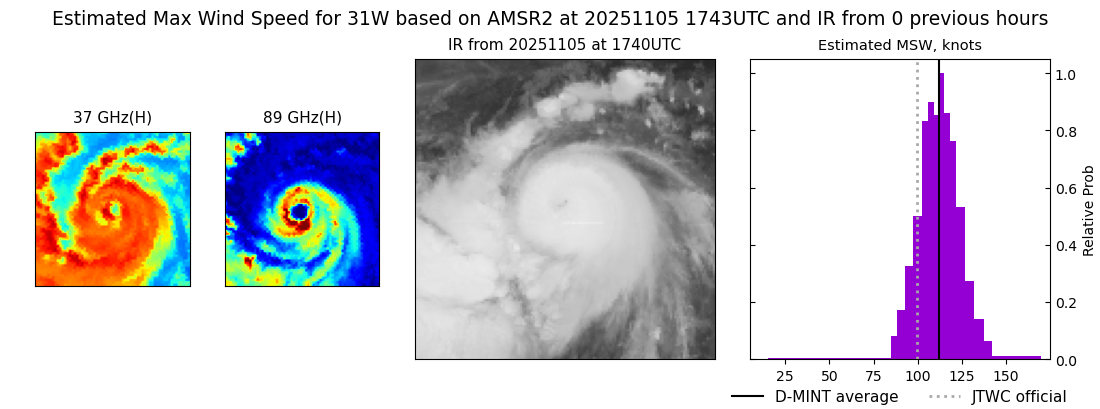 |
| 20251105 | 1440 UTC | TMS06 | 963 hPa | 98 kts | 90 kts | 105 kts |  |
| 20251105 | 0948 UTC | WSFM01 | 972 hPa | 77 kts | 71 kts | 84 kts |  |
| 20251105 | 0930 UTC | TROPICS03 | 969 hPa | 77 kts | 71 kts | 84 kts |  |
| 20251105 | 0528 UTC | AMSR2 | 966 hPa | 87 kts | 80 kts | 94 kts | 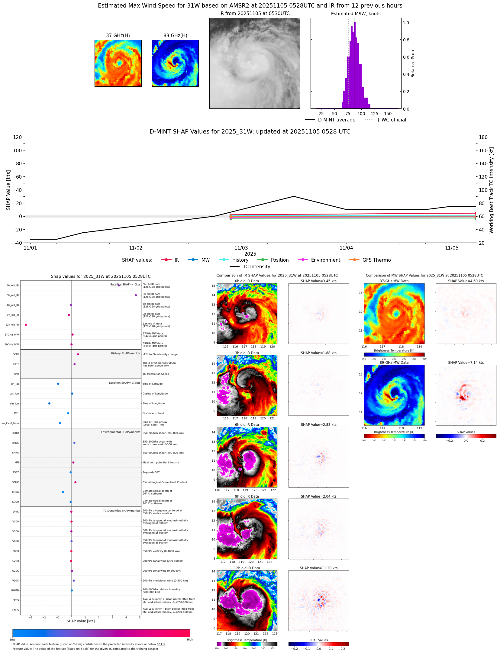 |
| 20251105 | 0504 UTC | ATMS-N20 | 966 hPa | 88 kts | 82 kts | 96 kts |  |
| 20251105 | 0412 UTC | TMS07 | 970 hPa | 74 kts | 67 kts | 80 kts |  |
| 20251105 | 0224 UTC | TMS05 | 981 hPa | 63 kts | 56 kts | 69 kts | 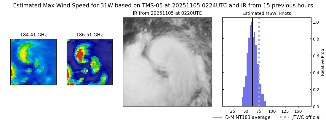 |
| 20251104 | 2323 UTC | GMI | 976 hPa | 71 kts | 65 kts | 78 kts | 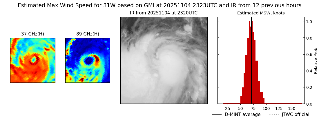 |
| 20251104 | 2240 UTC | SSMISF16 | 980 hPa | 69 kts | 62 kts | 76 kts | 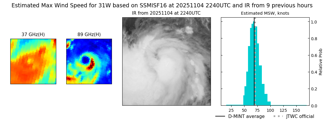 |
| 20251104 | 2145 UTC | TROPICS05 | 980 hPa | 70 kts | 62 kts | 78 kts |  |
| 20251104 | 1708 UTC | ATMS-N21 | 980 hPa | 61 kts | 55 kts | 68 kts | 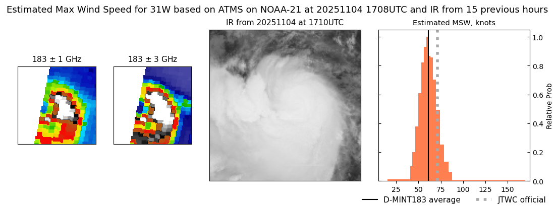 |
| 20251104 | 1409 UTC | TMS05 | 983 hPa | 56 kts | 50 kts | 63 kts |  |
| 20251104 | 1148 UTC | GMI | 985 hPa | 55 kts | 47 kts | 63 kts | 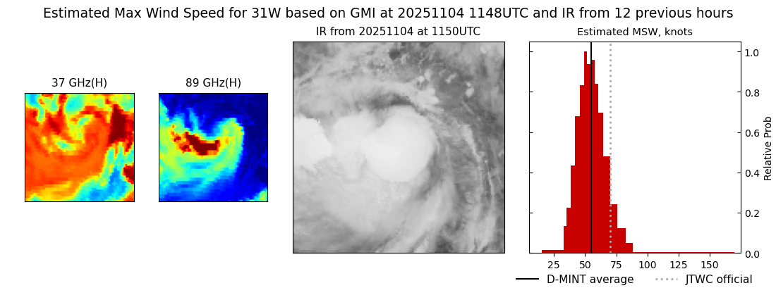 |
| 20251104 | 1007 UTC | WSFM01 | 987 hPa | 56 kts | 48 kts | 64 kts | 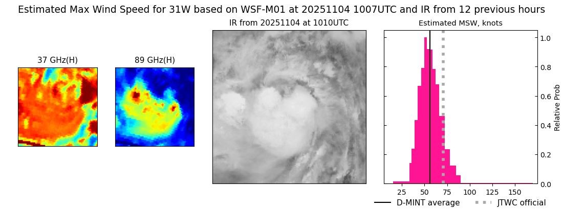 |
| 20251104 | 0523 UTC | ATMS-N20 | 973 hPa | 68 kts | 61 kts | 75 kts |  |
| 20251104 | 0411 UTC | TMS07 | 977 hPa | 68 kts | 61 kts | 75 kts | 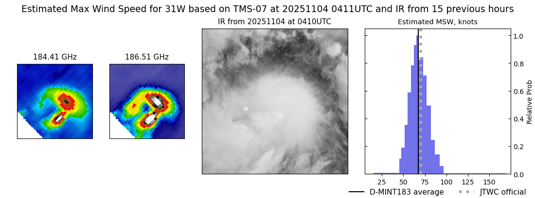 |
| 20251104 | 0215 UTC | TMS02 | 971 hPa | 73 kts | 67 kts | 80 kts | 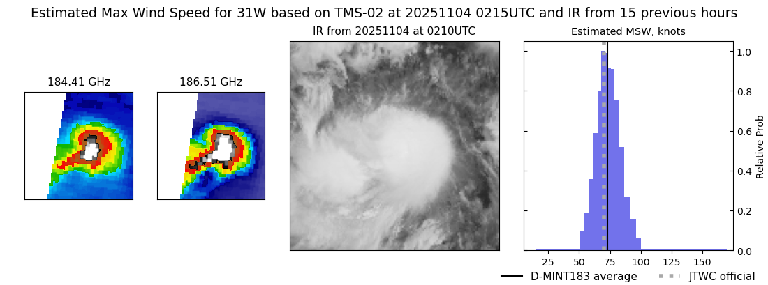 |
| 20251103 | 1758 UTC | TMS07 | 971 hPa | 87 kts | 78 kts | 95 kts |  |
| 20251103 | 1726 UTC | ATMS-N21 | 970 hPa | 78 kts | 69 kts | 86 kts | 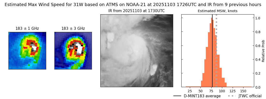 |
| 20251103 | 1351 UTC | TMS06 | 962 hPa | 91 kts | 82 kts | 99 kts | 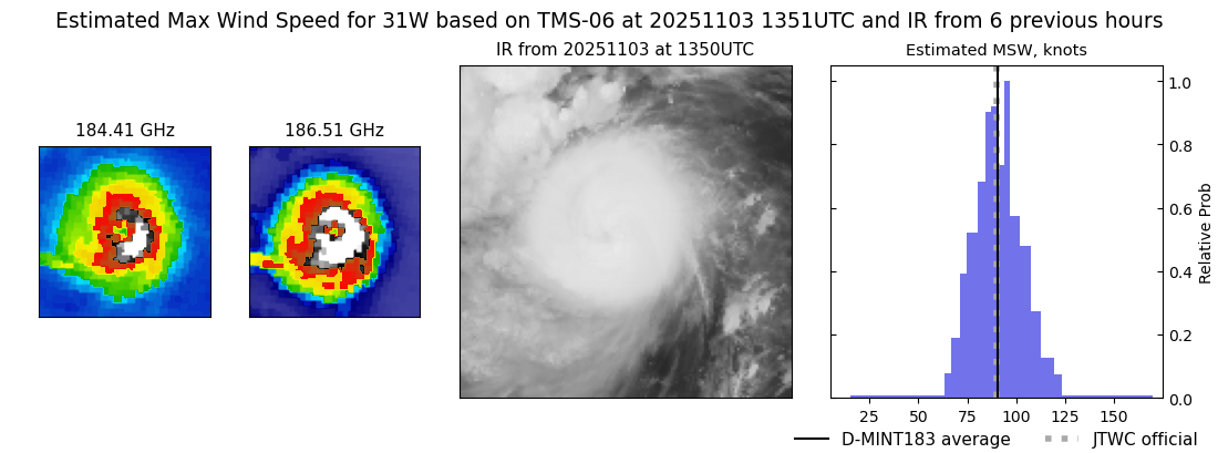 |
| 20251103 | 1020 UTC | TROPICS03 | 965 hPa | 82 kts | 76 kts | 89 kts |  |
| 20251103 | 1015 UTC | SSMISF16 | 971 hPa | 68 kts | 61 kts | 76 kts |  |
| 20251103 | 0451 UTC | ATMS-N21 | 976 hPa | 67 kts | 60 kts | 74 kts |  |
| 20251103 | 0408 UTC | TMS07 | 973 hPa | 66 kts | 59 kts | 73 kts |  |
| 20251103 | 0036 UTC | TROPICS03 | 982 hPa | 62 kts | 56 kts | 68 kts | 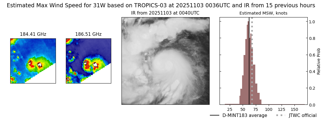 |
| 20251102 | 2313 UTC | GMI | 978 hPa | 66 kts | 58 kts | 73 kts | 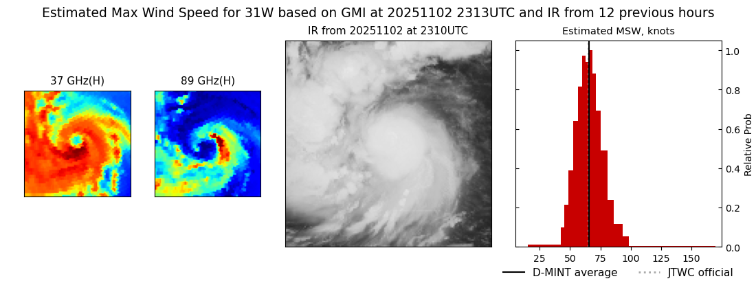 |
| 20251102 | 2141 UTC | WSFM01 | 979 hPa | 68 kts | 61 kts | 75 kts | 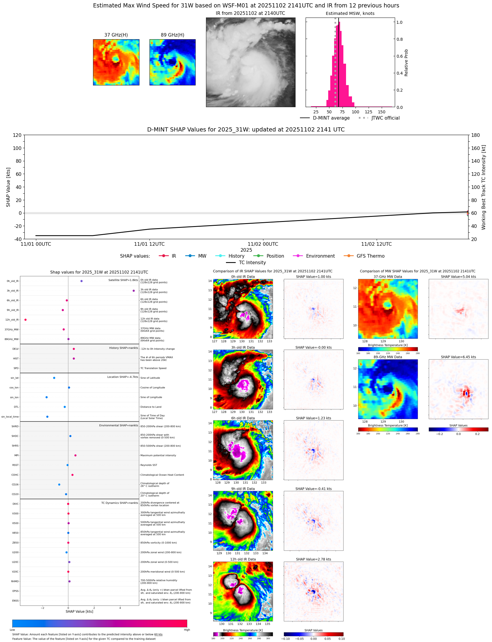 |
| 20251102 | 1910 UTC | SSMISF18 | 996 hPa | 31 kts | 27 kts | 36 kts |  |
| 20251102 | 1858 UTC | TMS03 | 991 hPa | 46 kts | 40 kts | 52 kts | 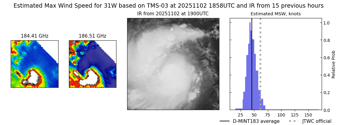 |
| 20251102 | 1712 UTC | AMSR2 | 991 hPa | 47 kts | 41 kts | 55 kts |  |
| 20251102 | 1655 UTC | ATMS-N20 | 989 hPa | 50 kts | 44 kts | 57 kts | 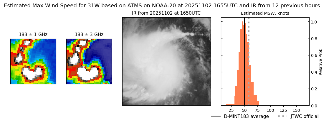 |
| 20251102 | 1310 UTC | TMS05 | 992 hPa | 49 kts | 42 kts | 56 kts | 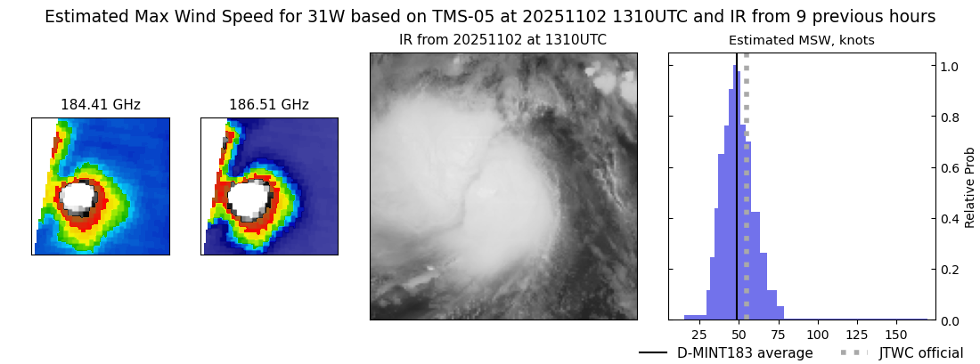 |
| 20251102 | 0633 UTC | SSMISF18 | 1003 hPa | 34 kts | 29 kts | 39 kts |  |
| 20251102 | 0420 UTC | ATMS-N20 | 1002 hPa | 35 kts | 30 kts | 41 kts | 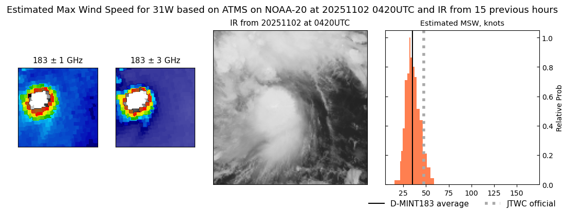 |
| 20251101 | 2140 UTC | SSMISF16 | 1002 hPa | 31 kts | 27 kts | 35 kts |  |
| 20251101 | 2036 UTC | SSMISF17 | 1005 hPa | 27 kts | 24 kts | 31 kts | 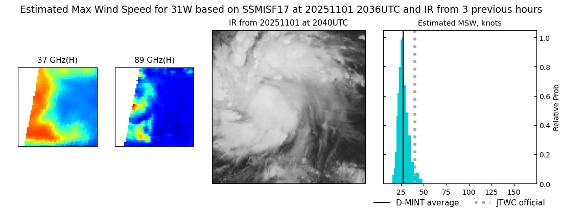 |
| 20251101 | 1924 UTC | SSMISF18 | 1001 hPa | 38 kts | 32 kts | 44 kts |  |
| 20251101 | 1751 UTC | TMS07 | 998 hPa | 45 kts | 39 kts | 51 kts | 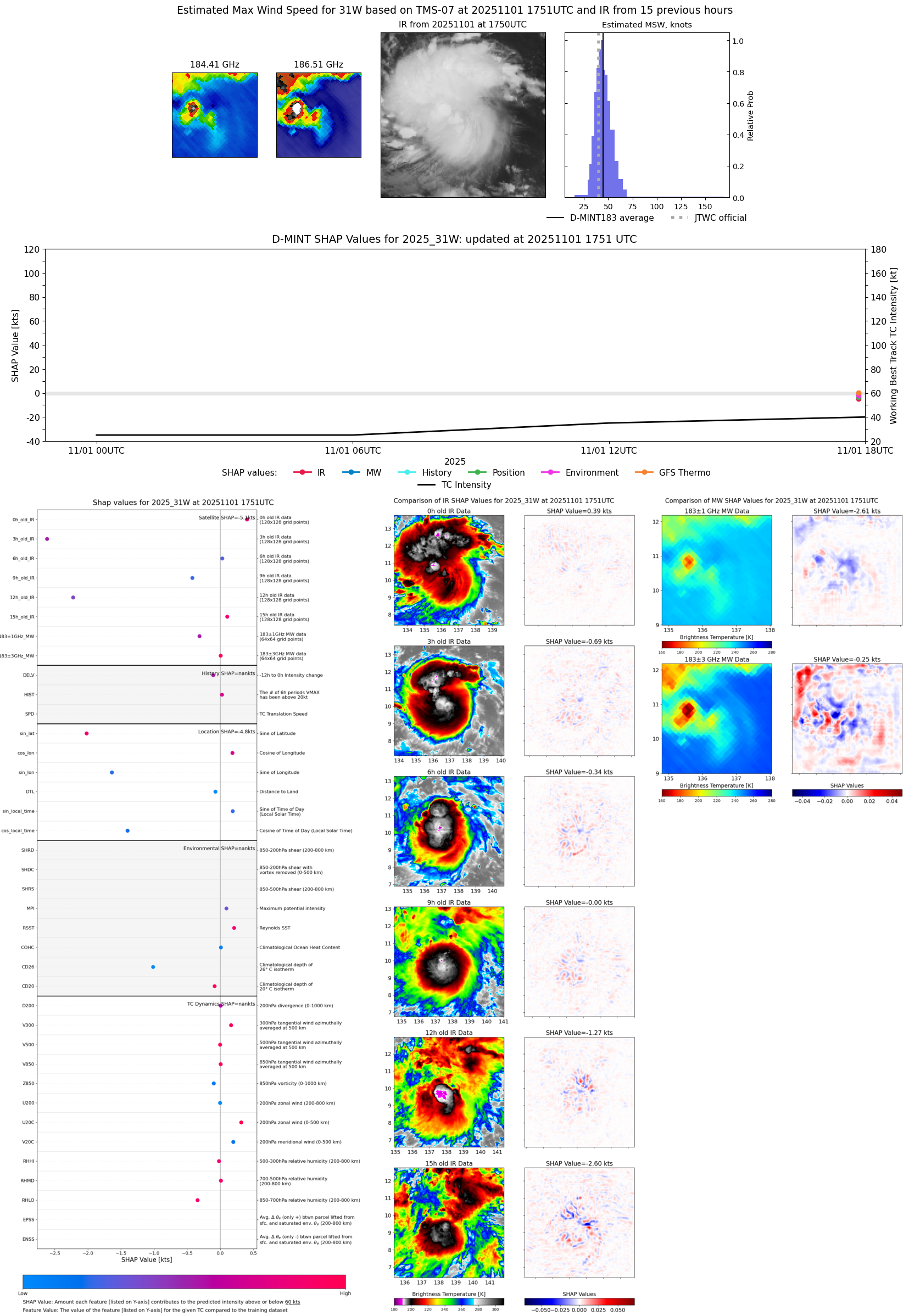 |
| 20251101 | 1629 UTC | AMSR2 | 998 hPa | 32 kts | 27 kts | 37 kts | 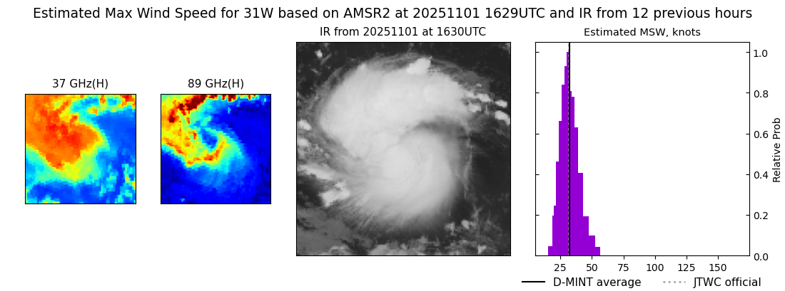 |
| 20251101 | 1623 UTC | ATMS-N21 | 1003 hPa | 34 kts | 29 kts | 39 kts | 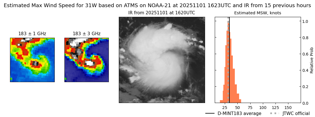 |
| 20251101 | 0645 UTC | SSMISF18 | 1001 hPa | 26 kts | 23 kts | 29 kts |  |
| 20251101 | 0417 UTC | ATMS-NPP | 1005 hPa | 25 kts | 22 kts | 28 kts | 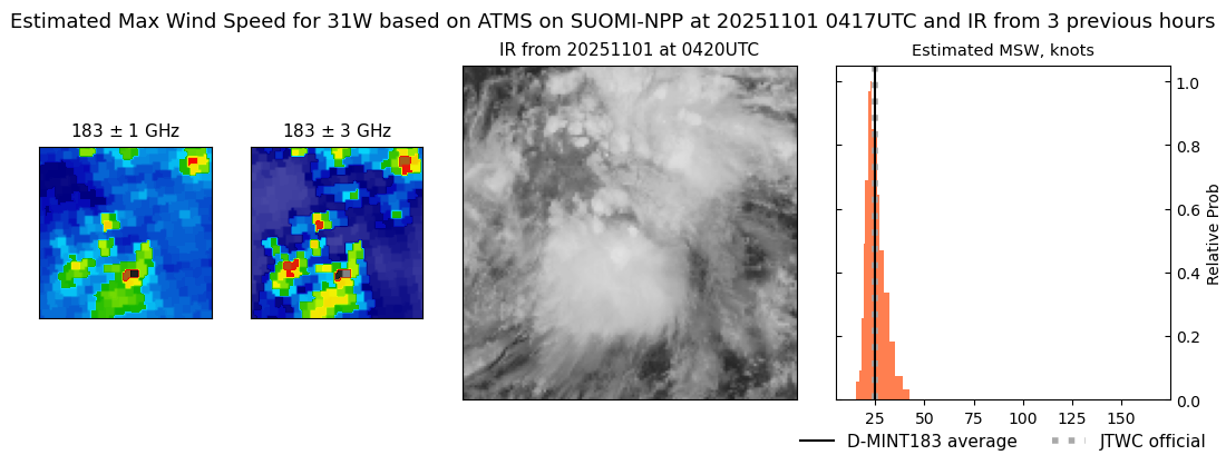 |
| 20251101 | 0348 UTC | ATMS-N21 | 1004 hPa | 24 kts | 22 kts | 27 kts | 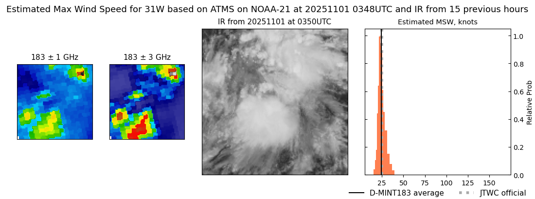 |
| 20251031 | 2305 UTC | GMI | NaN hPa | 19 kts | 16 kts | 21 kts |  |
| 20251031 | 2154 UTC | SSMISF16 | NaN hPa | 22 kts | 20 kts | 25 kts | 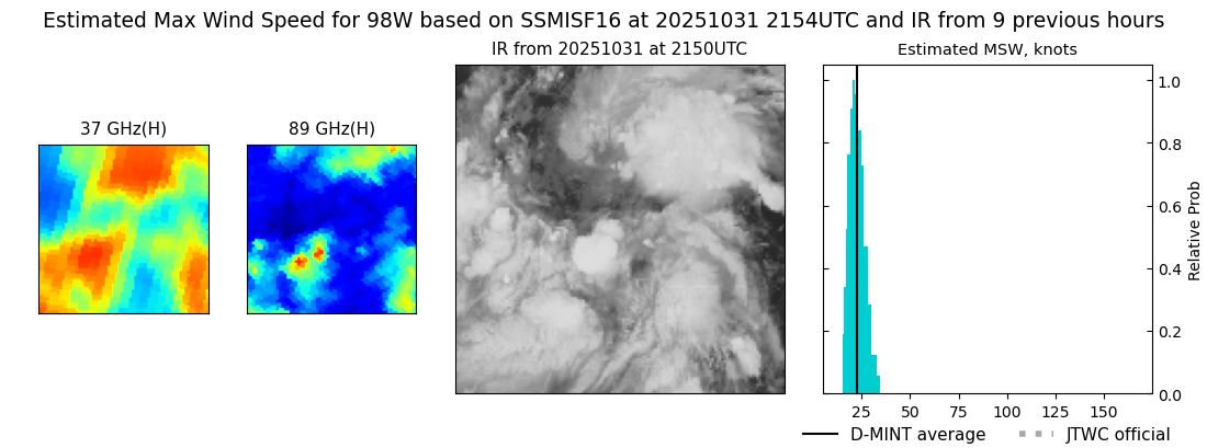 |
| 20251031 | 2049 UTC | SSMISF17 | NaN hPa | 20 kts | 17 kts | 23 kts |  |
| 20251031 | 1131 UTC | GMI | NaN hPa | 24 kts | 20 kts | 28 kts |  |