|
||
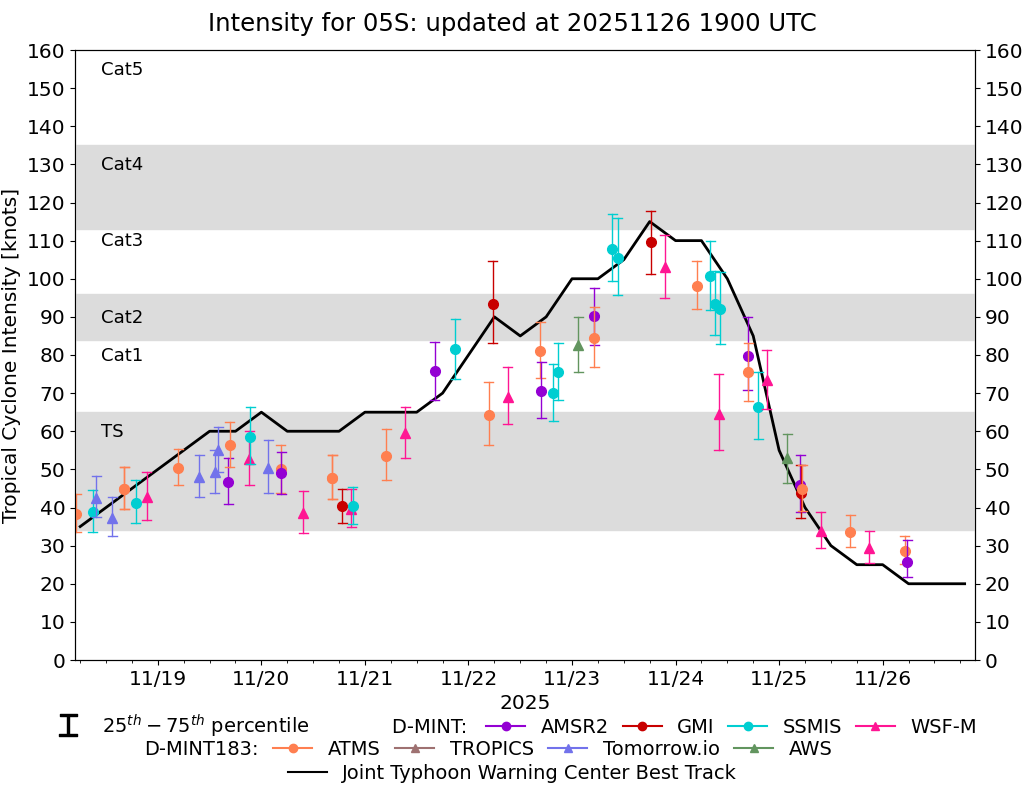 |
D-MINT HISTORY FILE for 2026_05S
| Date | Time | MW Sensor | MSLP | Vmax (30th-70th percentile average) | Vmax 25th percentile | Vmax 75th percentile | Image |
| 20251126 | 0539 UTC | AMSR2 | 1001 hPa | 26 kts | 22 kts | 32 kts | 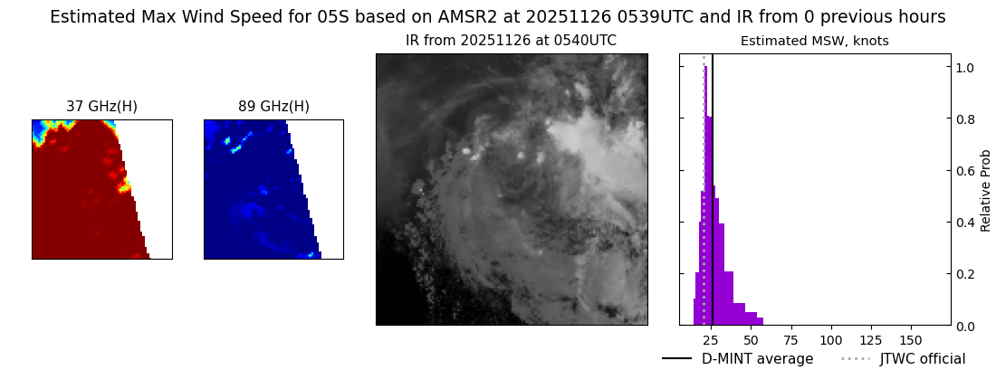 |
| 20251126 | 0504 UTC | ATMS-N20 | 1000 hPa | 29 kts | 25 kts | 33 kts |  |
| 20251125 | 2052 UTC | WSFM01 | 996 hPa | 29 kts | 25 kts | 34 kts | 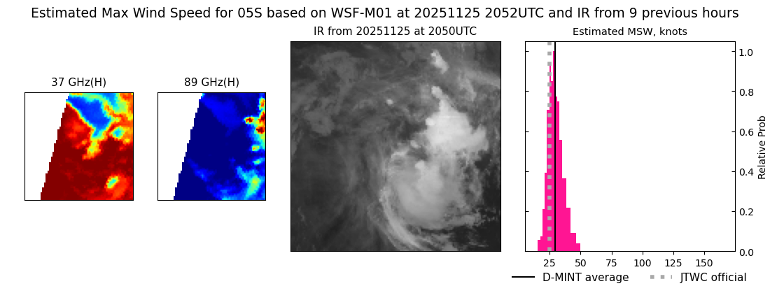 |
| 20251125 | 1632 UTC | ATMS-N20 | 997 hPa | 34 kts | 30 kts | 38 kts |  |
| 20251125 | 0942 UTC | WSFM01 | 989 hPa | 34 kts | 30 kts | 39 kts | 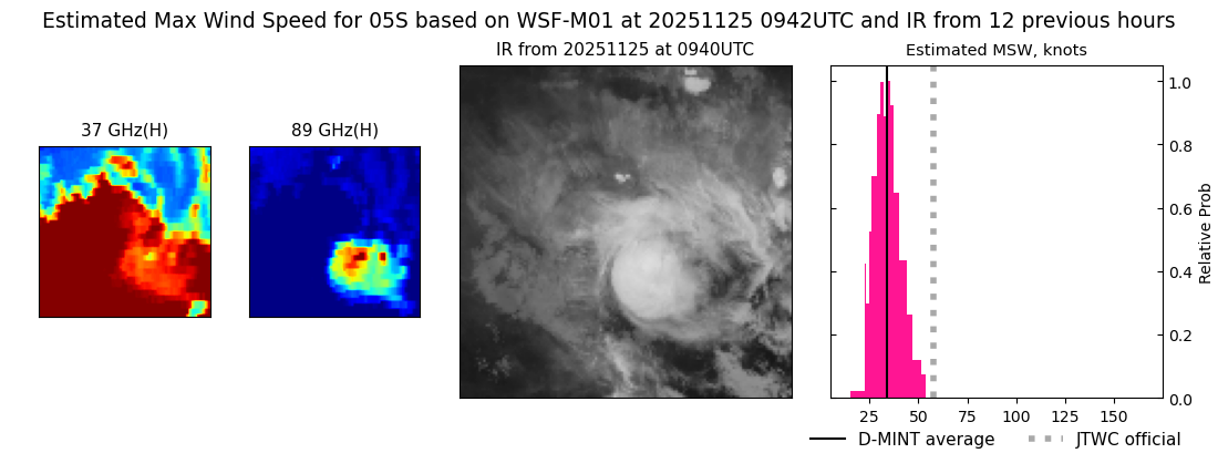 |
| 20251125 | 0523 UTC | ATMS-N20 | 989 hPa | 45 kts | 39 kts | 51 kts | 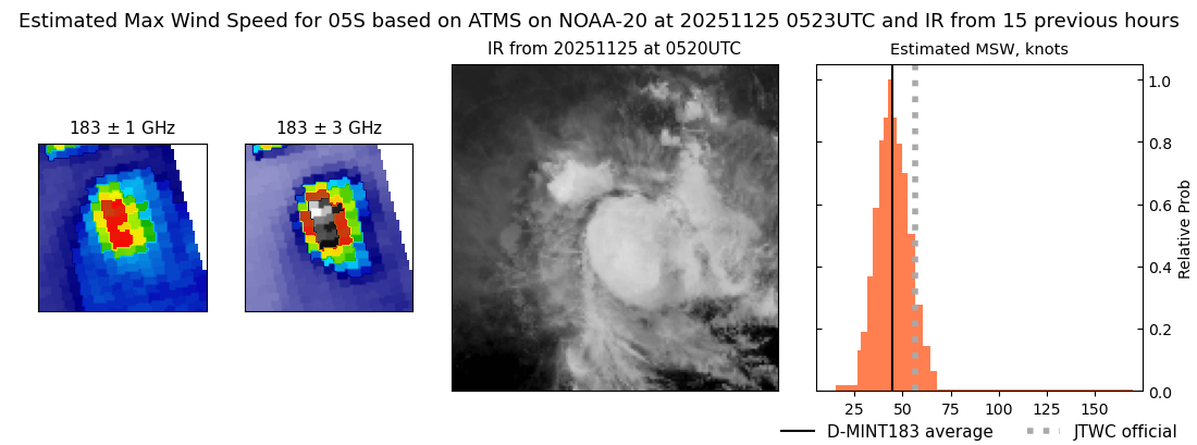 |
| 20251125 | 0504 UTC | GMI | 988 hPa | 44 kts | 37 kts | 51 kts | 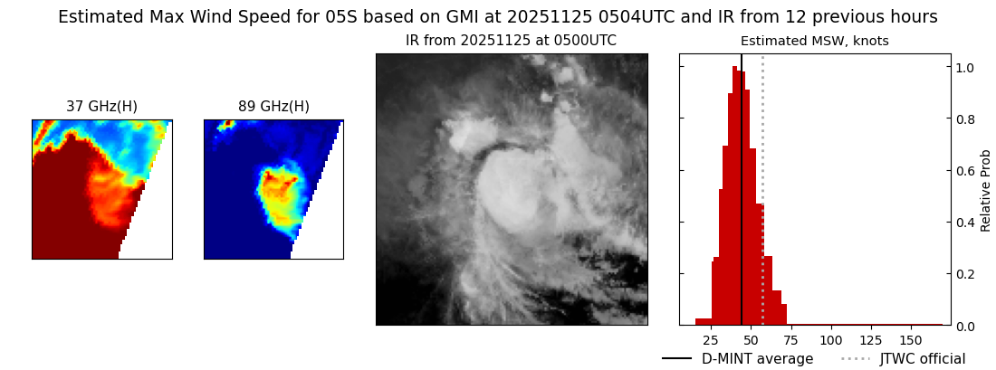 |
| 20251125 | 0456 UTC | AMSR2 | 984 hPa | 46 kts | 39 kts | 54 kts |  |
| 20251125 | 0151 UTC | AWS | 985 hPa | 53 kts | 47 kts | 59 kts | 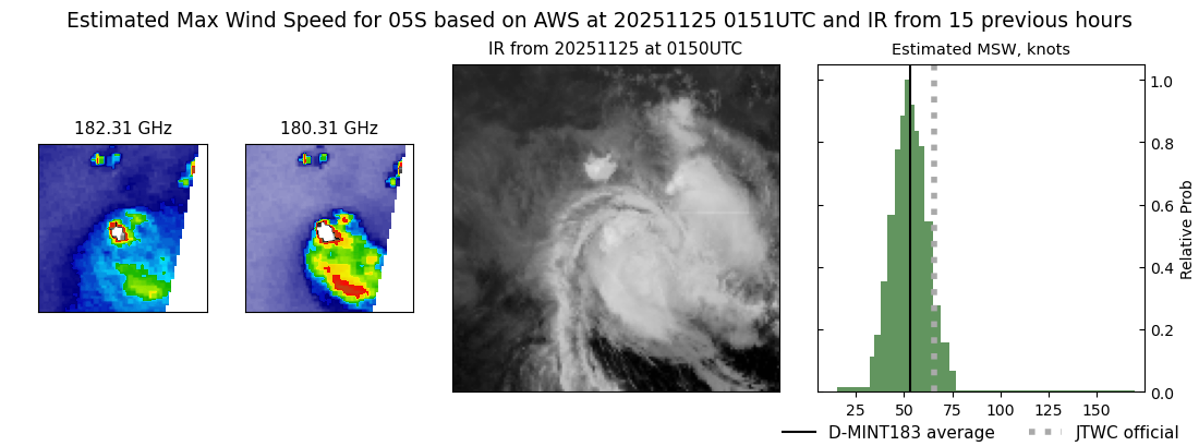 |
| 20251124 | 2110 UTC | WSFM01 | 968 hPa | 73 kts | 66 kts | 81 kts | 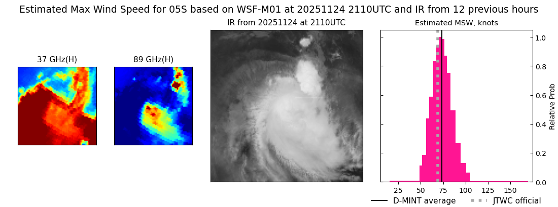 |
| 20251124 | 1909 UTC | SSMISF18 | 972 hPa | 66 kts | 58 kts | 75 kts | 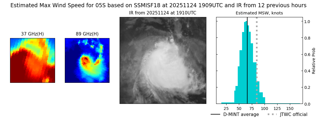 |
| 20251124 | 1650 UTC | ATMS-N20 | 973 hPa | 75 kts | 68 kts | 83 kts | 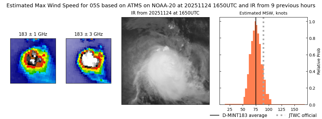 |
| 20251124 | 1642 UTC | AMSR2 | 967 hPa | 80 kts | 71 kts | 90 kts |  |
| 20251124 | 1023 UTC | SSMISF16 | 958 hPa | 92 kts | 83 kts | 102 kts |  |
| 20251124 | 1003 UTC | WSFM01 | 968 hPa | 65 kts | 55 kts | 75 kts |  |
| 20251124 | 0908 UTC | SSMISF17 | 949 hPa | 93 kts | 85 kts | 102 kts |  |
| 20251124 | 0800 UTC | SSMISF18 | 953 hPa | 101 kts | 92 kts | 110 kts | 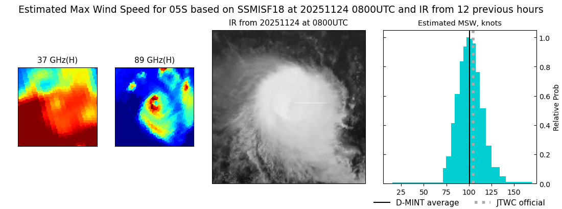 |
| 20251124 | 0452 UTC | ATMS-N21 | 951 hPa | 98 kts | 92 kts | 105 kts |  |
| 20251123 | 2130 UTC | WSFM01 | 946 hPa | 103 kts | 95 kts | 111 kts | 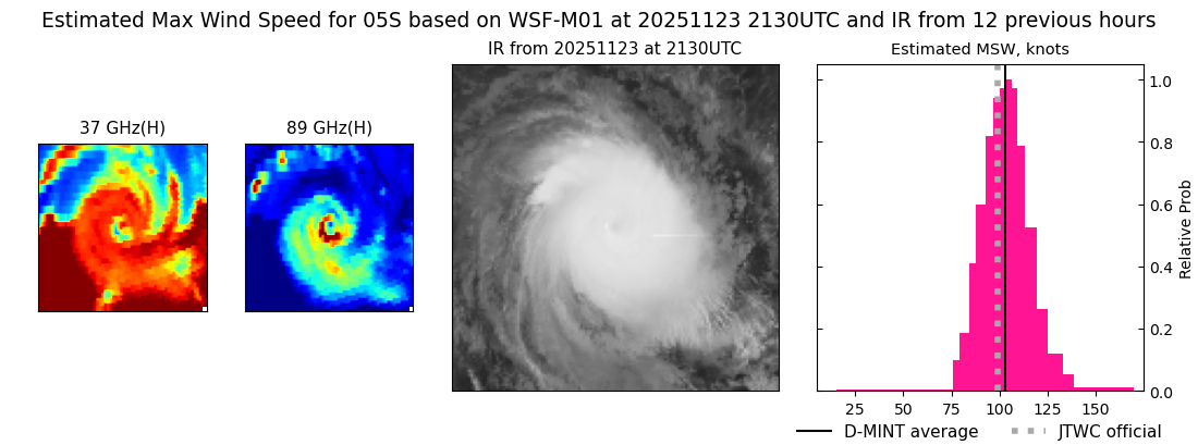 |
| 20251123 | 1814 UTC | GMI | 951 hPa | 110 kts | 101 kts | 118 kts | 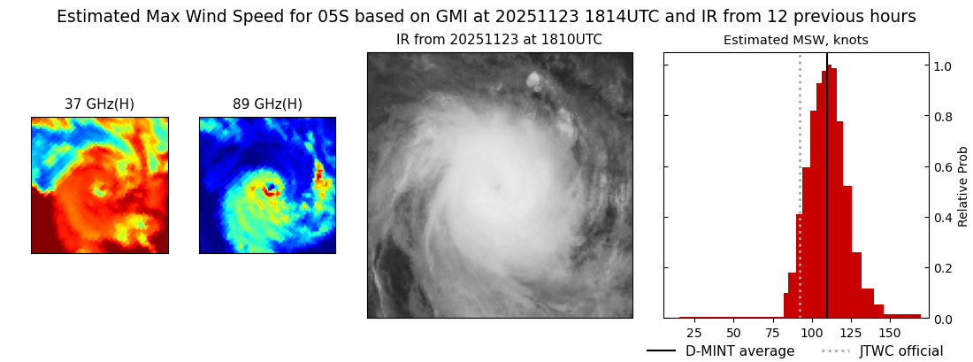 |
| 20251123 | 1037 UTC | SSMISF16 | 947 hPa | 105 kts | 96 kts | 116 kts |  |
| 20251123 | 0922 UTC | SSMISF17 | 937 hPa | 108 kts | 99 kts | 117 kts | 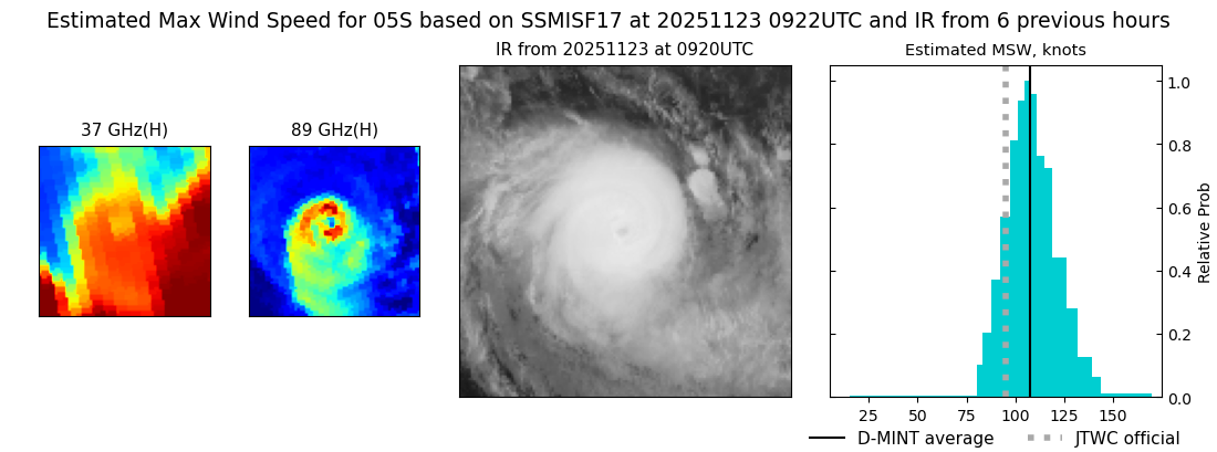 |
| 20251123 | 0510 UTC | ATMS-N21 | 966 hPa | 84 kts | 77 kts | 92 kts | 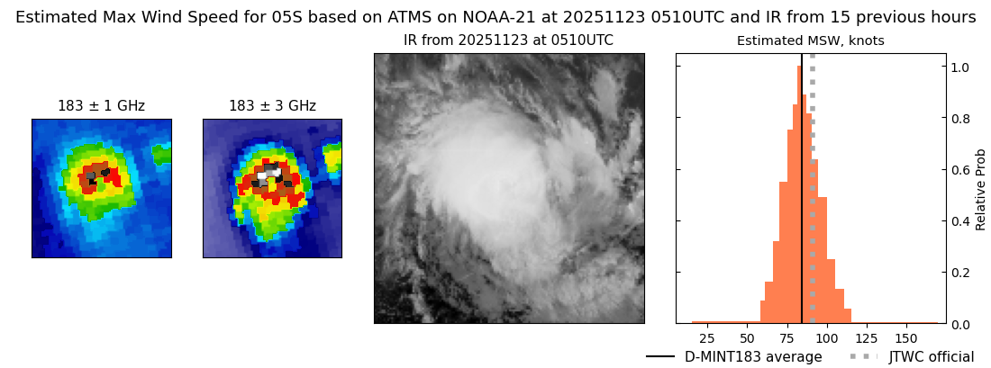 |
| 20251123 | 0508 UTC | AMSR2 | 955 hPa | 90 kts | 83 kts | 98 kts |  |
| 20251123 | 0129 UTC | AWS | 961 hPa | 83 kts | 76 kts | 90 kts | 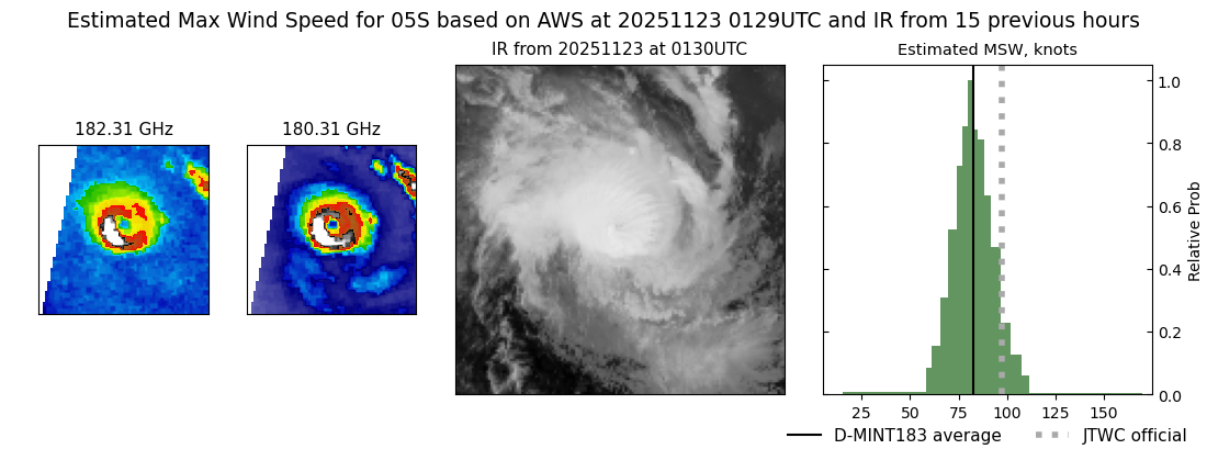 |
| 20251122 | 2046 UTC | SSMISF17 | 963 hPa | 75 kts | 68 kts | 83 kts |  |
| 20251122 | 1938 UTC | SSMISF18 | 965 hPa | 70 kts | 63 kts | 78 kts |  |
| 20251122 | 1654 UTC | AMSR2 | 959 hPa | 71 kts | 64 kts | 78 kts |  |
| 20251122 | 1636 UTC | ATMS-N21 | 968 hPa | 81 kts | 74 kts | 89 kts |  |
| 20251122 | 0903 UTC | WSFM01 | 972 hPa | 69 kts | 62 kts | 77 kts |  |
| 20251122 | 0536 UTC | GMI | 953 hPa | 93 kts | 83 kts | 105 kts | 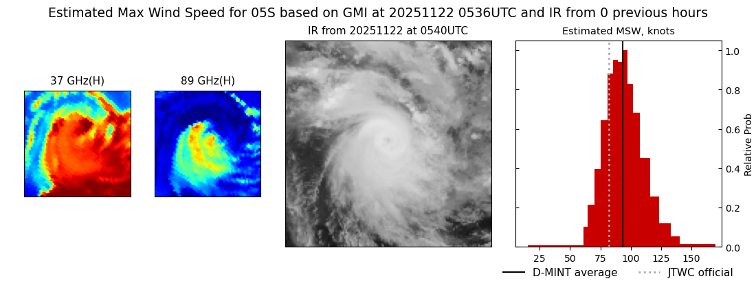 |
| 20251122 | 0439 UTC | ATMS-N20 | 974 hPa | 64 kts | 56 kts | 73 kts | 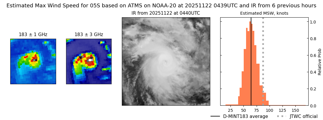 |
| 20251121 | 2059 UTC | SSMISF17 | 965 hPa | 82 kts | 74 kts | 89 kts | 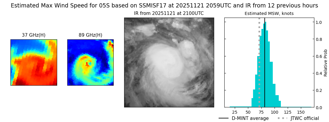 |
| 20251121 | 1611 UTC | AMSR2 | 969 hPa | 76 kts | 68 kts | 83 kts | 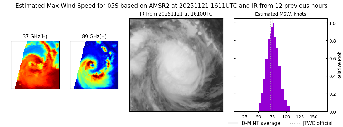 |
| 20251121 | 0922 UTC | WSFM01 | 978 hPa | 60 kts | 53 kts | 66 kts | 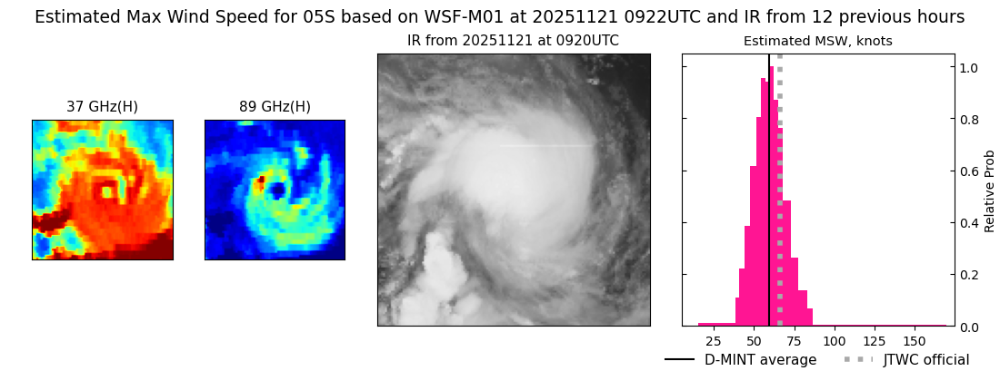 |
| 20251121 | 0459 UTC | ATMS-N20 | 986 hPa | 54 kts | 47 kts | 60 kts | 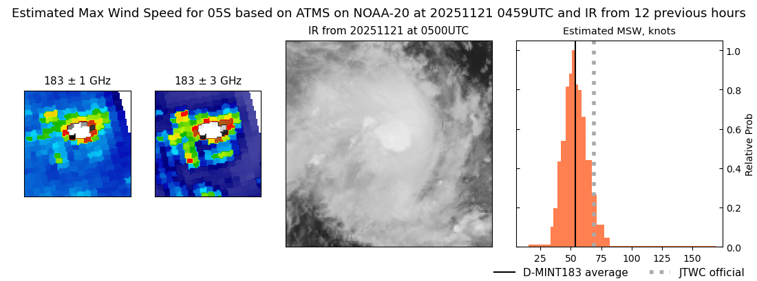 |
| 20251120 | 2113 UTC | SSMISF17 | 992 hPa | 40 kts | 36 kts | 45 kts | 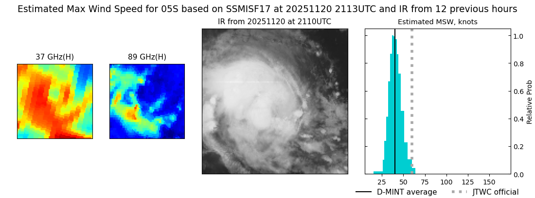 |
| 20251120 | 2048 UTC | WSFM01 | 992 hPa | 40 kts | 35 kts | 45 kts | 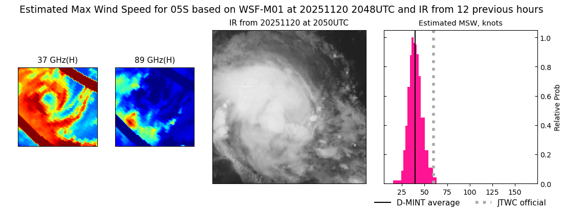 |
| 20251120 | 1845 UTC | GMI | 991 hPa | 40 kts | 36 kts | 45 kts |  |
| 20251120 | 1623 UTC | ATMS-N2 | 989 hPa | 48 kts | 42 kts | 54 kts | 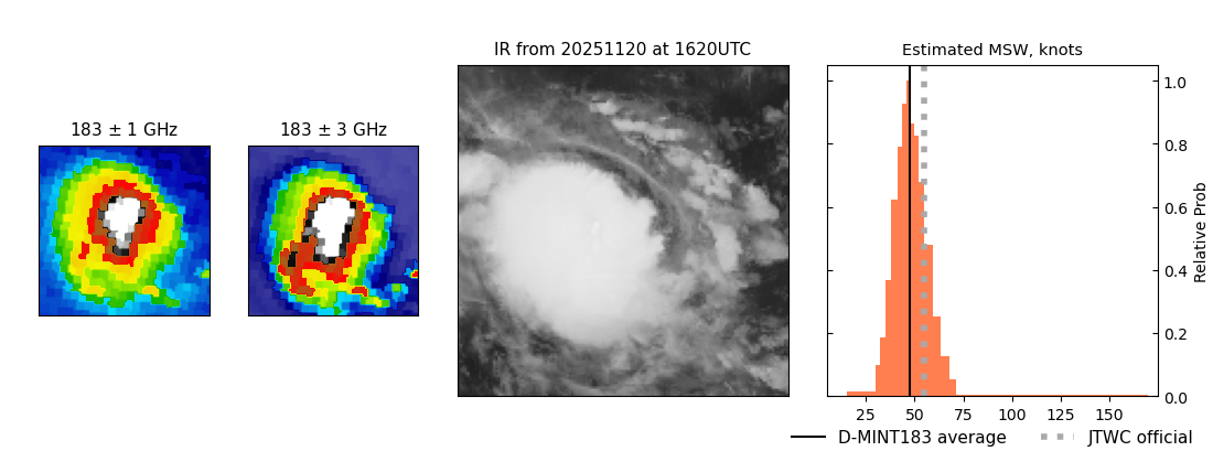 |
| 20251120 | 1623 UTC | ATMS-N20 | 989 hPa | 48 kts | 42 kts | 54 kts | 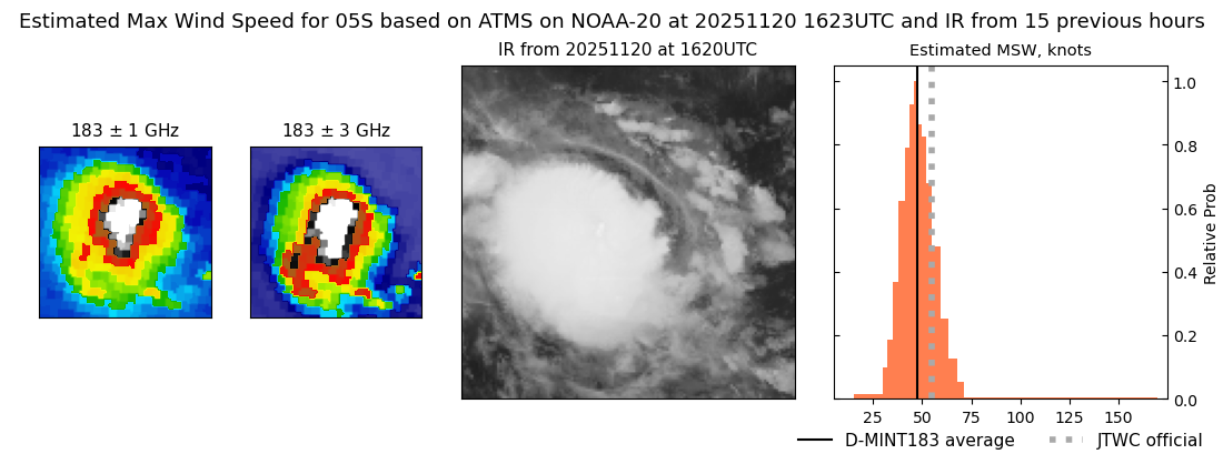 |
| 20251120 | 0944 UTC | WSFM01 | 993 hPa | 39 kts | 33 kts | 44 kts |  |
| 20251120 | 0438 UTC | AMSR2 | 989 hPa | 49 kts | 44 kts | 55 kts |  |
| 20251120 | 0427 UTC | ATMS-N21 | 990 hPa | 50 kts | 44 kts | 56 kts | 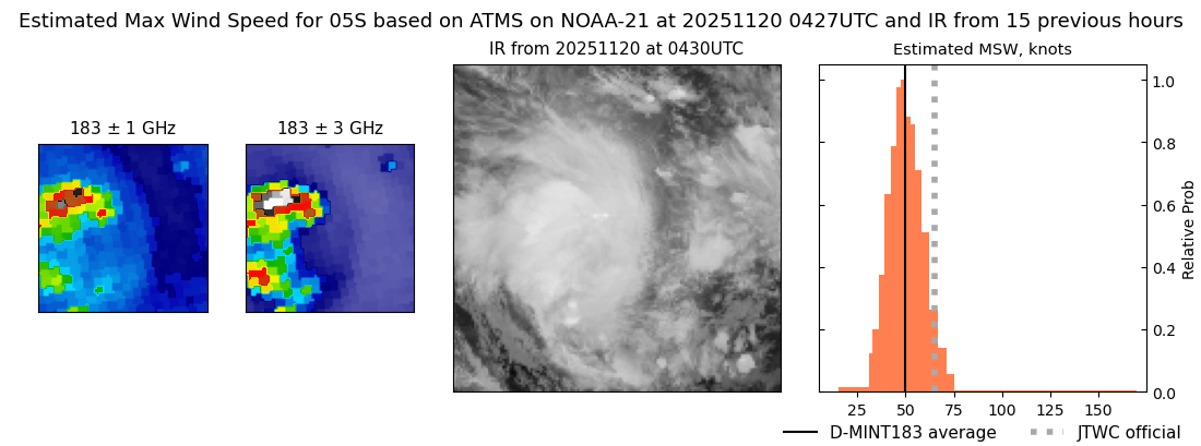 |
| 20251120 | 0135 UTC | TMS02 | 990 hPa | 50 kts | 44 kts | 58 kts | 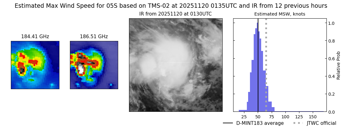 |
| 20251119 | 2127 UTC | SSMISF17 | 985 hPa | 59 kts | 51 kts | 66 kts | 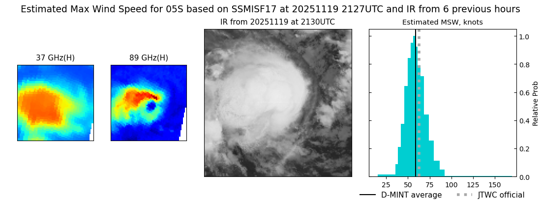 |
| 20251119 | 2108 UTC | WSFM01 | 985 hPa | 53 kts | 46 kts | 60 kts |  |
| 20251119 | 1642 UTC | ATMS-N20 | 981 hPa | 56 kts | 51 kts | 62 kts |  |
| 20251119 | 1622 UTC | AMSR2 | 988 hPa | 47 kts | 41 kts | 53 kts |  |
| 20251119 | 1400 UTC | TMS02 | 985 hPa | 55 kts | 49 kts | 61 kts | 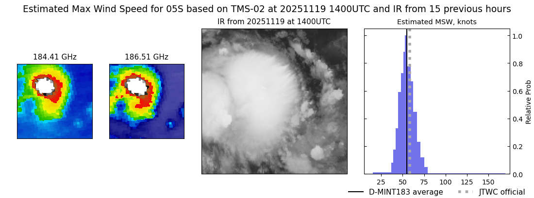 |
| 20251119 | 1314 UTC | TMS05 | 987 hPa | 49 kts | 44 kts | 55 kts | 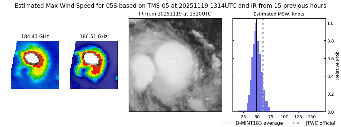 |
| 20251119 | 0938 UTC | TMS07 | 980 hPa | 48 kts | 43 kts | 54 kts |  |
| 20251119 | 0446 UTC | ATMS-N21 | 981 hPa | 50 kts | 46 kts | 55 kts | 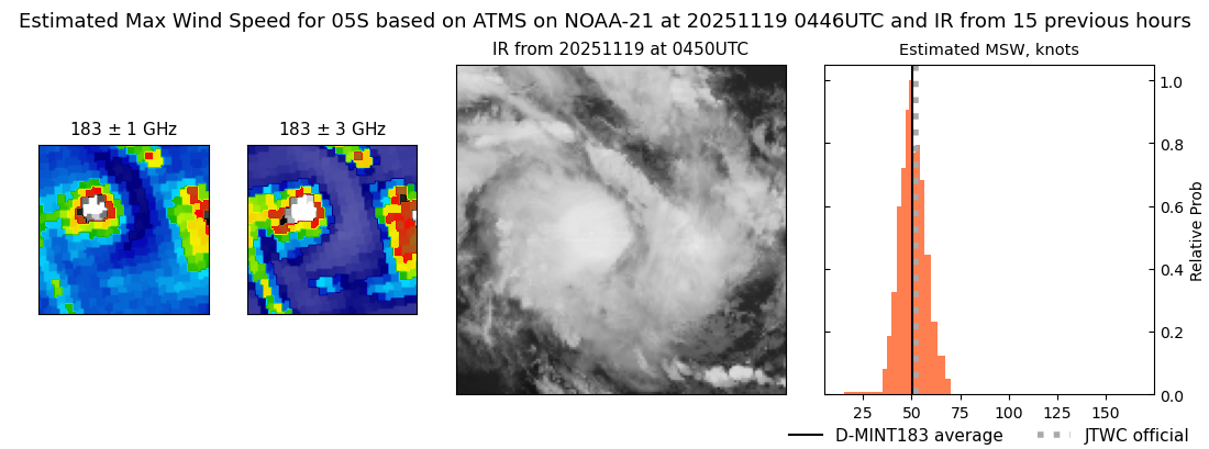 |
| 20251118 | 2128 UTC | WSFM01 | 985 hPa | 43 kts | 37 kts | 49 kts | 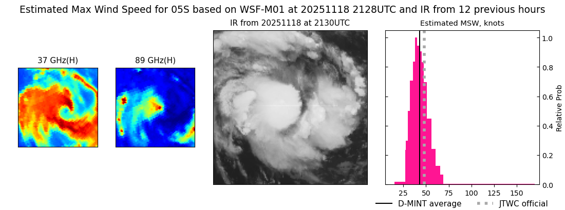 |
| 20251118 | 1852 UTC | SSMISF18 | 991 hPa | 41 kts | 36 kts | 47 kts | 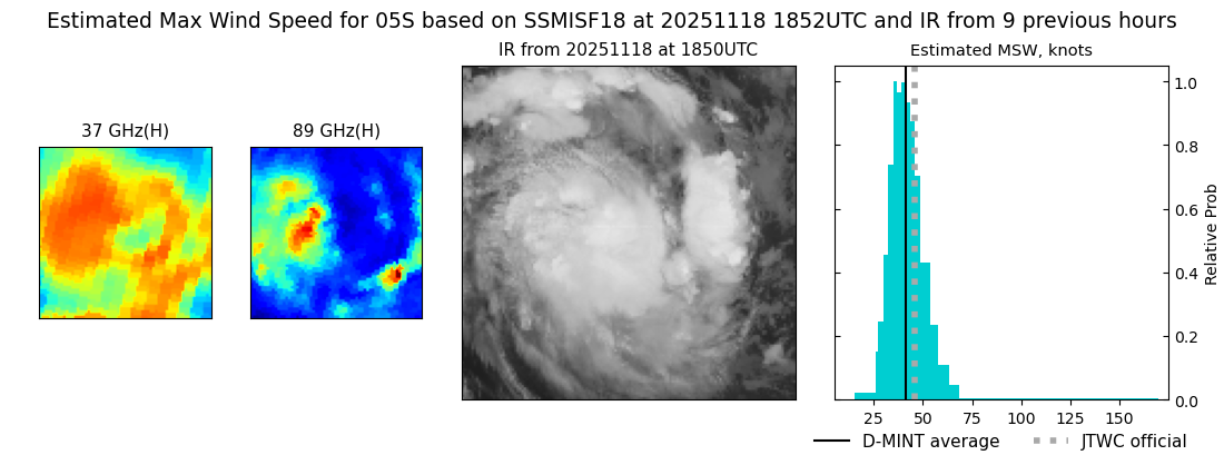 |
| 20251118 | 1611 UTC | ATMS- | 990 hPa | 45 kts | 40 kts | 51 kts | 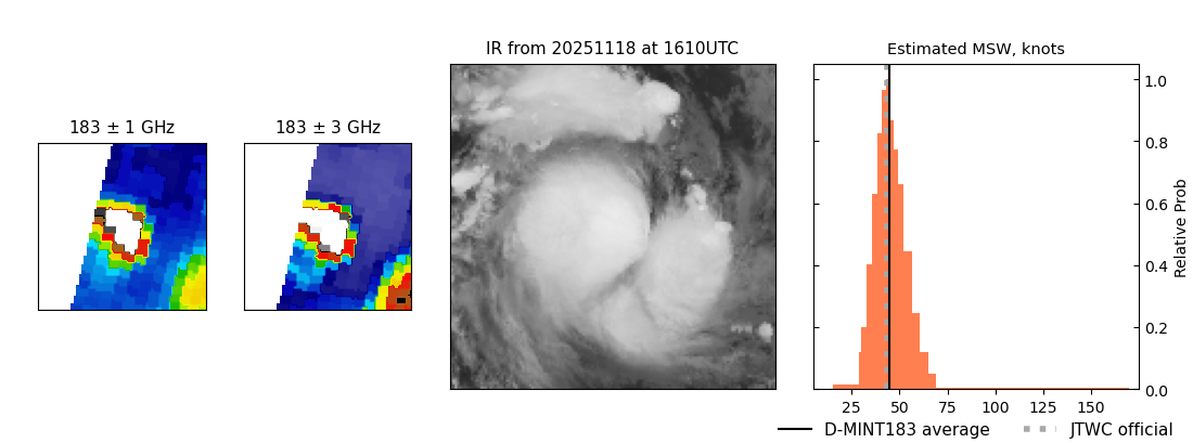 |
| 20251118 | 1611 UTC | ATMS-N21 | 990 hPa | 45 kts | 40 kts | 51 kts | 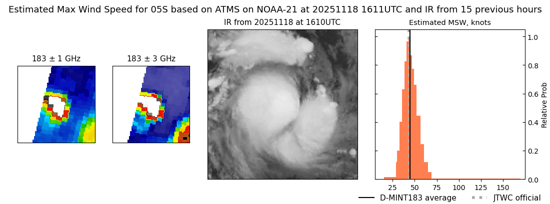 |
| 20251118 | 1325 UTC | TMS05 | 991 hPa | 37 kts | 33 kts | 43 kts | 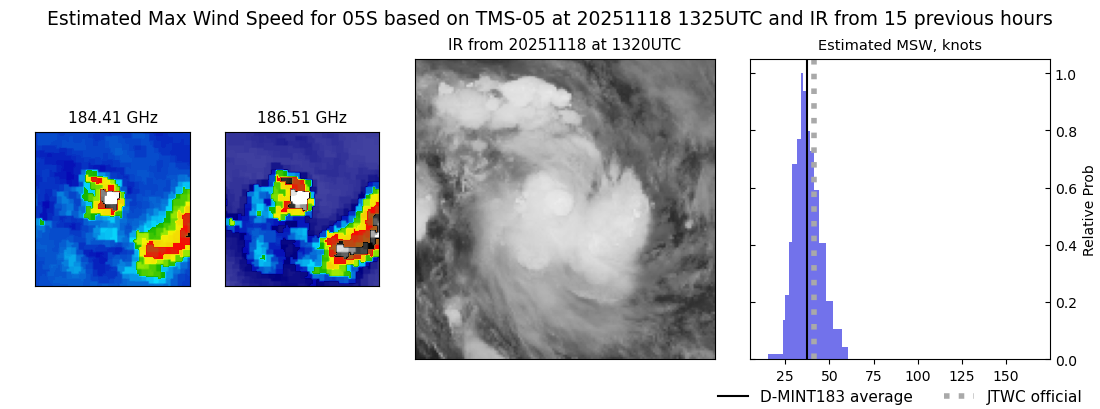 |
| 20251118 | 0946 UTC | TMS07 | 987 hPa | 42 kts | 37 kts | 48 kts | 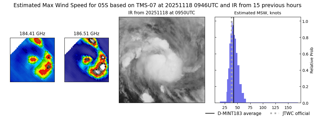 |
| 20251118 | 0854 UTC | SSMISF17 | 990 hPa | 39 kts | 34 kts | 45 kts |  |
| 20251118 | 0504 UTC | ATMS-N21 | 987 hPa | 38 kts | 34 kts | 44 kts | 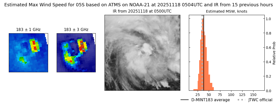 |
| 20251118 | 0138 UTC | TMS05 | 993 hPa | 36 kts | 32 kts | 42 kts |  |
| 20251118 | 0038 UTC | TMS03 | 989 hPa | 46 kts | 41 kts | 52 kts | 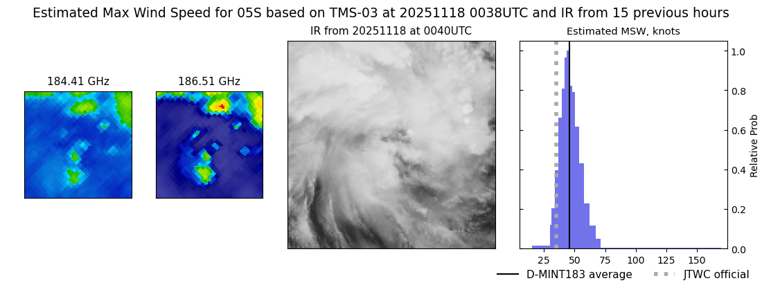 |
| 20251117 | 1630 UTC | ATMS-N21 | 992 hPa | 44 kts | 38 kts | 50 kts |  |
| 20251117 | 1400 UTC | AWS | 998 hPa | 33 kts | 29 kts | 39 kts | 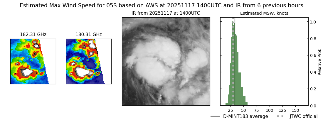 |
| 20251117 | 0903 UTC | WSFM01 | 999 hPa | 26 kts | 23 kts | 30 kts | 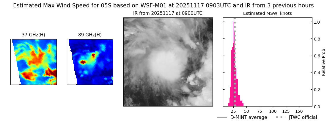 |
| 20251115 | 1648 UTC | AMSR2 | NaN hPa | 20 kts | 17 kts | 24 kts | 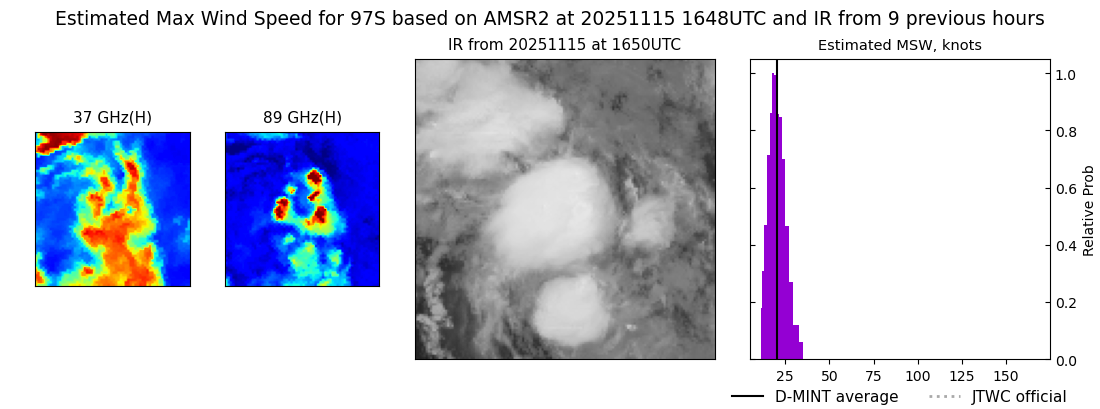 |
| 20251115 | 1046 UTC | SSMISF16 | NaN hPa | 17 kts | 14 kts | 20 kts | 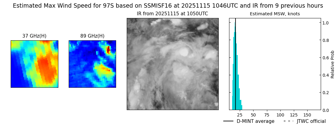 |
| 20251115 | 0827 UTC | SSMISF18 | NaN hPa | 20 kts | 17 kts | 24 kts | 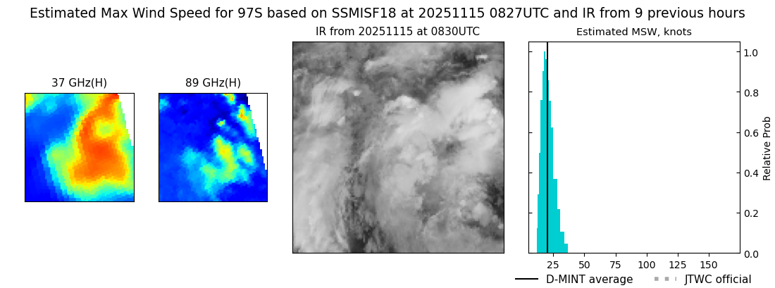 |
| 20251114 | 2210 UTC | SSMISF16 | NaN hPa | 17 kts | 15 kts | 20 kts | 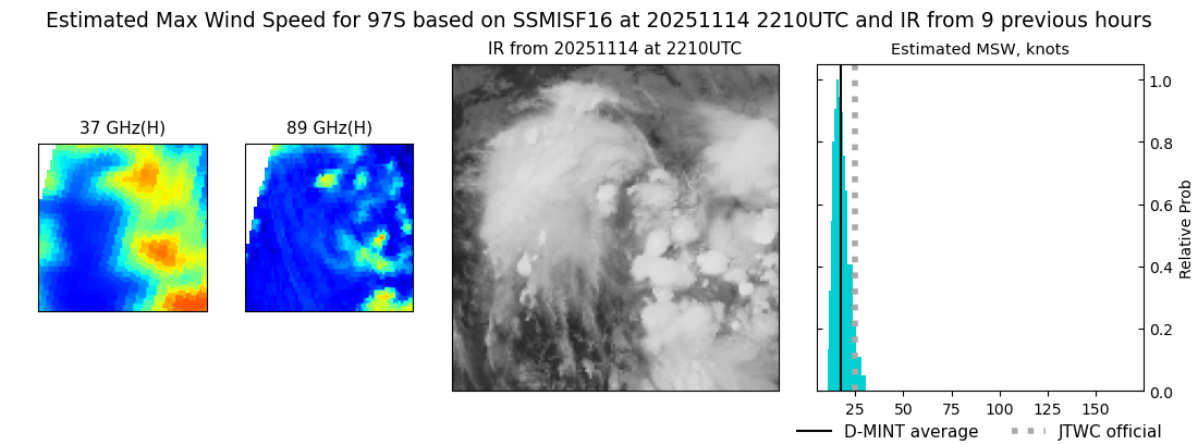 |
| 20251114 | 2120 UTC | GMI | NaN hPa | 16 kts | 14 kts | 18 kts | 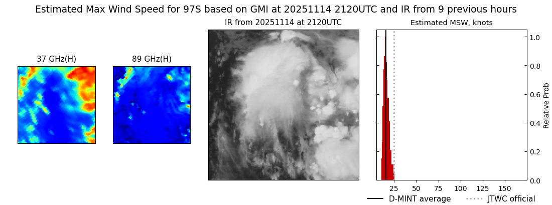 |
| 20251114 | 1950 UTC | SSMISF18 | NaN hPa | 17 kts | 14 kts | 20 kts | 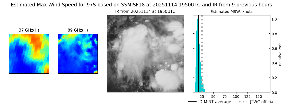 |
| 20251114 | 1743 UTC | AMSR2 | NaN hPa | 17 kts | 15 kts | 19 kts | 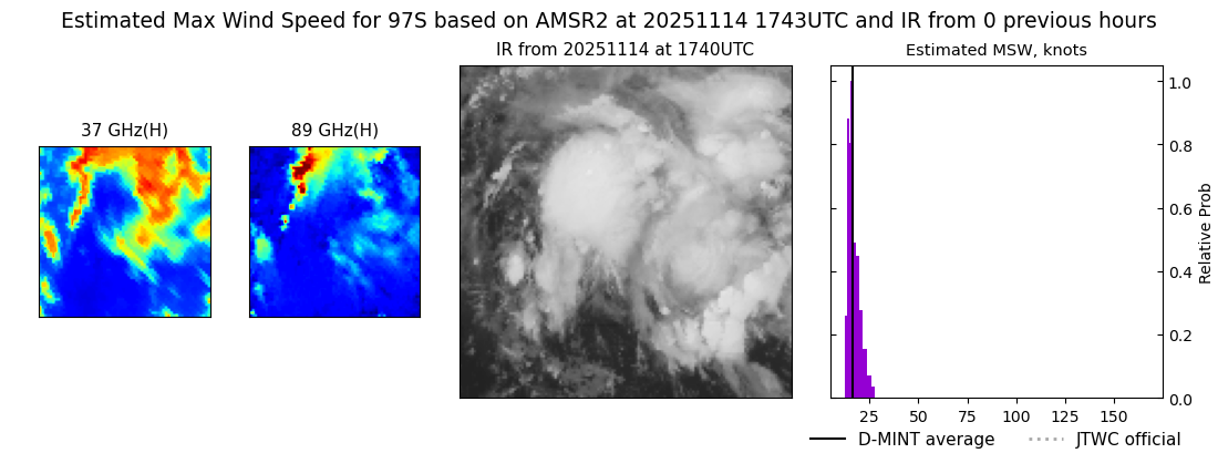 |