|
||
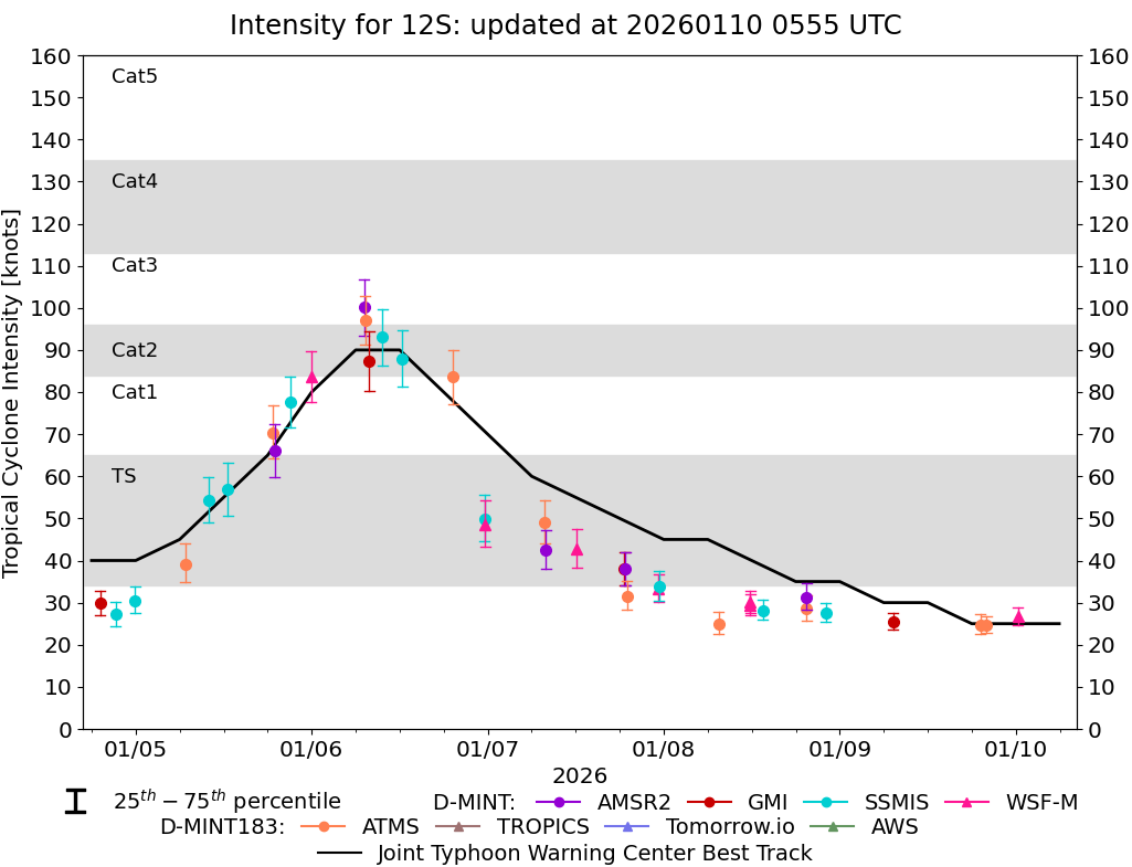 |
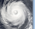
D-MINT HISTORY FILE for 2026_12S
| Date | Time | MW Sensor | MSLP | Vmax (30th-70th percentile average) | Vmax 25th percentile | Vmax 75th percentile | Image |
| 20260110 | 1248 UTC | WSFM01 | 1002 hPa | 25 kts | 23 kts | 27 kts |  |
| 20260110 | 0018 UTC | WSFM01 | 1001 hPa | 27 kts | 25 kts | 29 kts |  |
| 20260109 | 2002 UTC | ATMS-N21 | 1004 hPa | 25 kts | 23 kts | 27 kts |  |
| 20260109 | 1912 UTC | ATMS-N20 | 1004 hPa | 25 kts | 22 kts | 27 kts |  |
| 20260109 | 0717 UTC | GMI | NaN hPa | 25 kts | 24 kts | 27 kts |  |
| 20260108 | 2204 UTC | SSMISF18 | 1002 hPa | 28 kts | 26 kts | 30 kts |  |
| 20260108 | 1930 UTC | AMSR2 | 999 hPa | 31 kts | 28 kts | 35 kts |  |
| 20260108 | 1930 UTC | ATMS-N20 | 999 hPa | 29 kts | 26 kts | 32 kts |  |
| 20260108 | 1332 UTC | SSMISF16 | 1000 hPa | 28 kts | 26 kts | 31 kts |  |
| 20260108 | 1149 UTC | WSFM01 | 997 hPa | 29 kts | 27 kts | 32 kts |  |
| 20260108 | 1149 UTC | WSFM01 | 997 hPa | 30 kts | 28 kts | 33 kts |  |
| 20260108 | 0730 UTC | ATMS-N21 | 1000 hPa | 25 kts | 23 kts | 28 kts |  |
| 20260107 | 2321 UTC | SSMISF17 | 994 hPa | 34 kts | 30 kts | 37 kts |  |
| 20260107 | 2319 UTC | WSFM01 | 994 hPa | 33 kts | 30 kts | 37 kts |  |
| 20260107 | 1859 UTC | ATMS-N21 | 1000 hPa | 32 kts | 28 kts | 35 kts |  |
| 20260107 | 1848 UTC | AMSR2 | 996 hPa | 38 kts | 34 kts | 42 kts |  |
| 20260107 | 1837 UTC | GMI | 996 hPa | 38 kts | 34 kts | 42 kts |  |
| 20260107 | 1208 UTC | WSFM01 | 991 hPa | 43 kts | 38 kts | 47 kts |  |
| 20260107 | 0754 UTC | AMSR2 | 991 hPa | 43 kts | 38 kts | 47 kts |  |
| 20260107 | 0748 UTC | ATMS-N21 | 993 hPa | 49 kts | 44 kts | 54 kts |  |
| 20260106 | 2337 UTC | WSFM01 | 983 hPa | 49 kts | 43 kts | 54 kts |  |
| 20260106 | 2333 UTC | SSMISF17 | 985 hPa | 50 kts | 45 kts | 56 kts |  |
| 20260106 | 1917 UTC | ATMS-N21 | 966 hPa | 84 kts | 77 kts | 90 kts |  |
| 20260106 | 1219 UTC | SSMISF16 | 958 hPa | 88 kts | 81 kts | 95 kts |  |
| 20260106 | 0940 UTC | SSMISF18 | 958 hPa | 93 kts | 86 kts | 100 kts |  |
| 20260106 | 0752 UTC | GMI | 962 hPa | 87 kts | 80 kts | 95 kts |  |
| 20260106 | 0718 UTC | ATMS-N20 | 954 hPa | 97 kts | 91 kts | 103 kts |  |
| 20260106 | 0711 UTC | AMSR2 | 955 hPa | 100 kts | 93 kts | 107 kts |  |
| 20260105 | 2358 UTC | WSFM01 | 960 hPa | 84 kts | 78 kts | 90 kts |  |
| 20260105 | 2106 UTC | SSMISF18 | 974 hPa | 78 kts | 71 kts | 84 kts |  |
| 20260105 | 1858 UTC | AMSR2 | 982 hPa | 66 kts | 60 kts | 72 kts |  |
| 20260105 | 1845 UTC | ATMS-N20 | 978 hPa | 70 kts | 64 kts | 77 kts |  |
| 20260105 | 1232 UTC | SSMISF16 | 987 hPa | 57 kts | 51 kts | 63 kts |  |
| 20260105 | 0955 UTC | SSMISF18 | 990 hPa | 54 kts | 49 kts | 60 kts |  |
| 20260105 | 0648 UTC | ATMS-N21 | 998 hPa | 39 kts | 35 kts | 44 kts |  |
| 20260104 | 2356 UTC | SSMISF16 | 1001 hPa | 30 kts | 28 kts | 34 kts |  |
| 20260104 | 2118 UTC | SSMISF18 | 1001 hPa | 27 kts | 24 kts | 30 kts |  |
| 20260104 | 1912 UTC | GMI | 1001 hPa | 30 kts | 27 kts | 33 kts |  |
| 20260104 | 1130 UTC | WSFM01 | 1002 hPa | 30 kts | 27 kts | 34 kts |  |
| 20260104 | 0706 UTC | ATMS-N21 | 1000 hPa | 29 kts | 27 kts | 32 kts |  |
| 20260103 | 1150 UTC | WSFM01 | NaN hPa | 29 kts | 27 kts | 31 kts |  |
| 20260103 | 0030 UTC | SSMISF17 | NaN hPa | 18 kts | 15 kts | 21 kts |  |
| 20260102 | 2146 UTC | SSMISF18 | NaN hPa | 23 kts | 19 kts | 27 kts |  |
| 20260102 | 2040 UTC | GMI | NaN hPa | 20 kts | 17 kts | 24 kts |  |