|
||

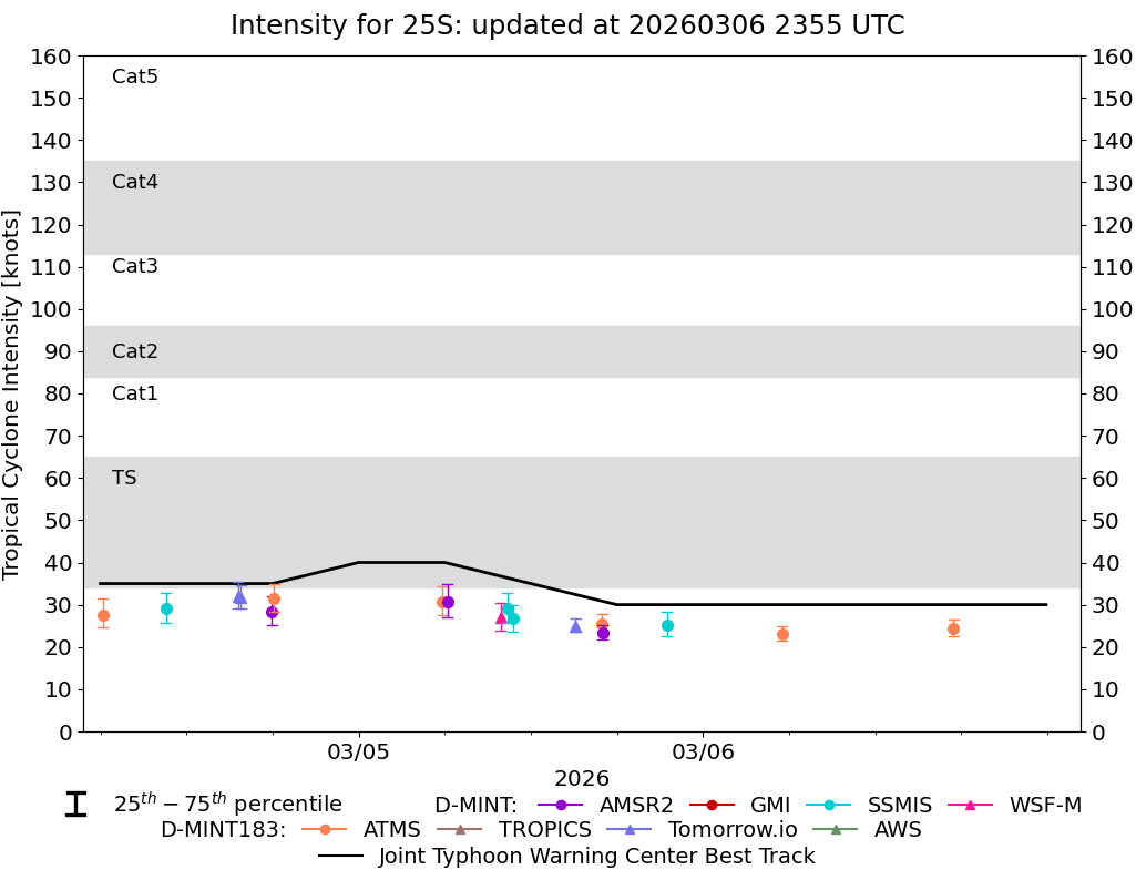 |
D-MINT HISTORY FILE for 2026_25S
| Date | Time | MW Sensor | MSLP | Vmax (30th-70th percentile average) | Vmax 25th percentile | Vmax 75th percentile | Image |
| 20260306 | 1728 UTC | ATMS-N21 | 999 hPa | 24 kts | 23 kts | 27 kts |  |
| 20260306 | 0532 UTC | ATMS-N20 | 1001 hPa | 23 kts | 22 kts | 25 kts |  |
| 20260305 | 2130 UTC | SSMISF17 | 997 hPa | 25 kts | 23 kts | 28 kts |  |
| 20260305 | 1701 UTC | AMSR2 | 998 hPa | 23 kts | 22 kts | 25 kts |  |
| 20260305 | 1658 UTC | ATMS-N20 | 998 hPa | 26 kts | 24 kts | 28 kts |  |
| 20260305 | 1508 UTC | TMS02 | 999 hPa | 25 kts | 24 kts | 27 kts |  |
| 20260305 | 1046 UTC | SSMISF16 | 996 hPa | 27 kts | 24 kts | 30 kts |  |
| 20260305 | 1021 UTC | SSMISF17 | 996 hPa | 29 kts | 26 kts | 33 kts |  |
| 20260305 | 0954 UTC | WSFM01 | 996 hPa | 27 kts | 24 kts | 30 kts |  |
| 20260305 | 0611 UTC | AMSR2 | 994 hPa | 31 kts | 27 kts | 35 kts |  |
| 20260305 | 0551 UTC | ATMS-N20 | 997 hPa | 31 kts | 28 kts | 34 kts |  |
| 20260304 | 1807 UTC | ATMS-N21 | 1001 hPa | 31 kts | 28 kts | 35 kts |  |
| 20260304 | 1756 UTC | AMSR2 | 998 hPa | 28 kts | 25 kts | 32 kts |  |
| 20260304 | 1547 UTC | TMS09 | 1000 hPa | 32 kts | 29 kts | 35 kts |  |
| 20260304 | 1535 UTC | TMS02 | 999 hPa | 32 kts | 29 kts | 35 kts |  |
| 20260304 | 1035 UTC | SSMISF17 | 999 hPa | 29 kts | 26 kts | 33 kts |  |
| 20260304 | 0611 UTC | ATMS-N20 | 999 hPa | 28 kts | 25 kts | 31 kts |  |
| 20260303 | 1825 UTC | ATMS-N21 | 1000 hPa | 33 kts | 29 kts | 37 kts |  |
| 20260303 | 1515 UTC | AWS | 1002 hPa | 27 kts | 24 kts | 29 kts |  |
| 20260303 | 1034 UTC | WSFM01 | 999 hPa | 32 kts | 29 kts | 36 kts |  |
| 20260301 | 2227 UTC | SSMISF17 | NaN hPa | 18 kts | 16 kts | 22 kts |  |
| 20260301 | 1142 UTC | SSMISF16 | NaN hPa | 22 kts | 18 kts | 26 kts |  |
| 20260301 | 0636 UTC | AMSR2 | NaN hPa | 16 kts | 14 kts | 19 kts |  |
| 20260228 | 2241 UTC | SSMISF17 | NaN hPa | 19 kts | 15 kts | 23 kts |  |
| 20260228 | 1821 UTC | AMSR2 | NaN hPa | 19 kts | 16 kts | 22 kts |  |
| 20260228 | 1155 UTC | SSMISF16 | NaN hPa | 16 kts | 14 kts | 19 kts |  |
| 20260228 | 1132 UTC | SSMISF17 | NaN hPa | 17 kts | 15 kts | 21 kts |  |
| 20260228 | 0300 UTC | GMI | NaN hPa | 18 kts | 16 kts | 22 kts |  |