|
||
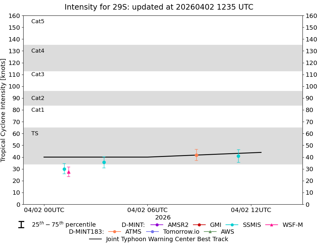 |
D-MINT HISTORY FILE for 2026_29S
| Date | Time | MW Sensor | MSLP | Vmax (30th-70th percentile average) | Vmax 25th percentile | Vmax 75th percentile | Image |
| 20260406 | 0909 UTC | ATMS-N20 | 1008 hPa | 25 kts | 23 kts | 27 kts |  |
| 20260406 | 0236 UTC | SSMISF16 | 995 hPa | 39 kts | 34 kts | 44 kts |  |
| 20260406 | 0019 UTC | SSMISF17 | 999 hPa | 33 kts | 29 kts | 37 kts |  |
| 20260406 | 0012 UTC | WSFM01 | 999 hPa | 35 kts | 31 kts | 39 kts |  |
| 20260405 | 2047 UTC | ATMS-N20 | 1000 hPa | 43 kts | 38 kts | 48 kts |  |
| 20260405 | 1955 UTC | ATMS-N21 | 1000 hPa | 42 kts | 38 kts | 47 kts |  |
| 20260405 | 0929 UTC | ATMS-N20 | 995 hPa | 43 kts | 39 kts | 48 kts |  |
| 20260405 | 0838 UTC | ATMS-N21 | 997 hPa | 40 kts | 35 kts | 46 kts |  |
| 20260405 | 0031 UTC | SSMISF17 | 985 hPa | 49 kts | 43 kts | 56 kts |  |
| 20260405 | 0030 UTC | WSFM01 | 985 hPa | 48 kts | 42 kts | 54 kts |  |
| 20260404 | 2103 UTC | ATMS-N20 | 977 hPa | 72 kts | 66 kts | 78 kts |  |
| 20260404 | 2034 UTC | AMSR2 | 979 hPa | 71 kts | 64 kts | 78 kts |  |
| 20260404 | 2012 UTC | ATMS-N21 | 981 hPa | 69 kts | 63 kts | 75 kts |  |
| 20260404 | 1810 UTC | TMS02 | 972 hPa | 79 kts | 73 kts | 87 kts |  |
| 20260404 | 1316 UTC | WSFM01 | 971 hPa | 85 kts | 78 kts | 93 kts |  |
| 20260404 | 0859 UTC | ATMS-N21 | 969 hPa | 83 kts | 77 kts | 89 kts |  |
| 20260404 | 0047 UTC | WSFM01 | 967 hPa | 88 kts | 81 kts | 95 kts |  |
| 20260403 | 2029 UTC | ATMS-N21 | 973 hPa | 81 kts | 74 kts | 87 kts |  |
| 20260403 | 1840 UTC | TMS02 | 978 hPa | 59 kts | 53 kts | 66 kts |  |
| 20260403 | 1543 UTC | SSMISF16 | 988 hPa | 54 kts | 48 kts | 60 kts |  |
| 20260403 | 1337 UTC | WSFM01 | 991 hPa | 50 kts | 44 kts | 56 kts |  |
| 20260403 | 0919 UTC | ATMS-N21 | 993 hPa | 53 kts | 48 kts | 59 kts |  |
| 20260403 | 0830 UTC | ATMS-N20 | 994 hPa | 44 kts | 39 kts | 49 kts |  |
| 20260403 | 0608 UTC | TMS09 | 988 hPa | 60 kts | 54 kts | 66 kts |  |
| 20260403 | 0529 UTC | TMS02 | 997 hPa | 57 kts | 51 kts | 63 kts |  |
| 20260403 | 0316 UTC | SSMISF16 | 991 hPa | 48 kts | 42 kts | 54 kts |  |
| 20260403 | 0105 UTC | WSFM01 | 991 hPa | 41 kts | 36 kts | 47 kts |  |
| 20260403 | 0056 UTC | SSMISF17 | 992 hPa | 40 kts | 35 kts | 46 kts |  |
| 20260402 | 2046 UTC | ATMS-N21 | 997 hPa | 49 kts | 44 kts | 54 kts |  |
| 20260402 | 2043 UTC | AMSR2 | 997 hPa | 36 kts | 31 kts | 40 kts |  |
| 20260402 | 1957 UTC | ATMS-N20 | 995 hPa | 49 kts | 45 kts | 54 kts |  |
| 20260402 | 1736 UTC | TMS02 | 998 hPa | 39 kts | 34 kts | 44 kts |  |
| 20260402 | 1632 UTC | TMS09 | 993 hPa | 45 kts | 40 kts | 51 kts |  |
| 20260402 | 1116 UTC | SSMISF18 | 998 hPa | 41 kts | 36 kts | 47 kts |  |
| 20260402 | 0850 UTC | ATMS-N20 | 995 hPa | 42 kts | 37 kts | 47 kts |  |
| 20260402 | 0626 UTC | TMS09 | 998 hPa | 41 kts | 36 kts | 47 kts |  |
| 20260402 | 0557 UTC | TMS02 | 997 hPa | 40 kts | 35 kts | 45 kts |  |
| 20260402 | 0328 UTC | SSMISF16 | 1000 hPa | 36 kts | 31 kts | 40 kts |  |
| 20260402 | 0125 UTC | WSFM01 | 1000 hPa | 28 kts | 24 kts | 32 kts |  |
| 20260402 | 0110 UTC | SSMISF17 | 1001 hPa | 30 kts | 26 kts | 35 kts |  |
| 20260401 | 2015 UTC | ATMS-N20 | 1001 hPa | 34 kts | 30 kts | 38 kts |  |
| 20260401 | 1805 UTC | TMS02 | 1000 hPa | 34 kts | 30 kts | 39 kts |  |
| 20260401 | 1652 UTC | TMS09 | 1001 hPa | 27 kts | 25 kts | 31 kts |  |
| 20260401 | 0909 UTC | ATMS-N20 | 1003 hPa | 29 kts | 26 kts | 32 kts |  |
| 20260401 | 0818 UTC | ATMS-N21 | 1005 hPa | 29 kts | 26 kts | 32 kts |  |
| 20260401 | 0646 UTC | TMS09 | 1004 hPa | 27 kts | 24 kts | 30 kts |  |
| 20260401 | 0514 UTC | AWS | 1005 hPa | 28 kts | 25 kts | 32 kts |  |
| 20260331 | 2252 UTC | SSMISF18 | NaN hPa | 22 kts | 18 kts | 25 kts |  |
| 20260331 | 1236 UTC | SSMISF17 | NaN hPa | 18 kts | 15 kts | 21 kts |  |
| 20260331 | 0828 UTC | AMSR2 | NaN hPa | 16 kts | 14 kts | 18 kts |  |
| 20260330 | 2306 UTC | SSMISF18 | NaN hPa | 17 kts | 15 kts | 20 kts |  |
| 20260330 | 2011 UTC | AMSR2 | NaN hPa | 16 kts | 15 kts | 18 kts |  |
| 20260330 | 1250 UTC | SSMISF17 | NaN hPa | 19 kts | 16 kts | 22 kts |  |