|
| Geo IR |
85-92GHz |
| Date/Time_(UTC) |
Source |
Sensor |
Vmax(kts) |
ARCHER Lat |
Lon |
Geo-ref Lat |
Lon |
50% cert. rad. |
95% cert. rad. |
Eye diam (deg) |
% cert. of eye |
|
|
|
|
 |
 |
|
|
|
 |
 |
|
|
|
 |
 |
|
|
|
 |
 |
|
|
|
 |
 |
|
|
|
 |
 |
|
|
|
 |
 |
|
|
|
 |
 |
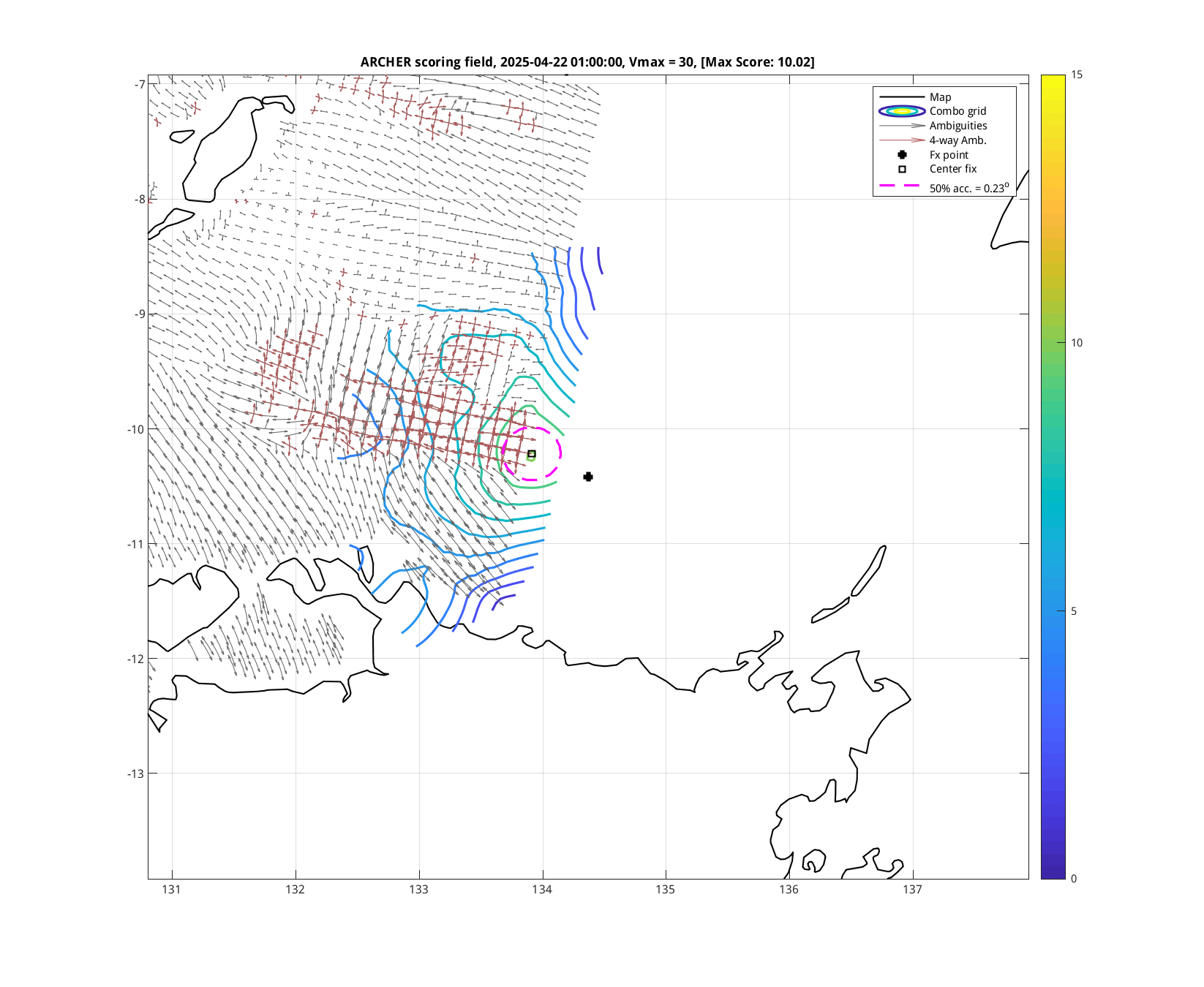
| 20250422 09:47:16 * |
SSMIS-17 |
85-92GHz |
31.6 |
-10.22 |
133.15 |
-10.28 |
133.29 |
0.23 |
0.65 |
0.90 |
14.2 |
| 20250422 09:18:44 |
SSMIS-16 |
85-92GHz |
31.4 |
-10.24 |
133.25 |
-10.28 |
133.34 |
0.28 |
0.79 |
0.30 |
9.7 |
|
|
|
 |
 |
|
|
|
 |
 |
|
|
|
 |
 |
| 20250421 21:09:18 * |
SSMIS-17 |
85-92GHz |
30.0 |
-11.54 |
135.38 |
-11.58 |
135.48 |
0.32 |
0.92 |
3.00 |
3.4 |
|
|
|
 |
 |
|
|
|
 |
 |
|
|
|
 |
 |
|
|
|
 |
 |
|
|
|
 |
 |
|
|
|
 |
 |
| 20250420 20:54:54 * |
SSMIS-16 |
85-92GHz |
30.0 |
-12.60 |
139.16 |
-12.63 |
139.24 |
0.23 |
0.65 |
2.50 |
3.7 |
|
|
|
 |
 |
|
|
|
 |
 |
|
|
|
 |
 |
| 20250420 08:32:28 * |
SSMIS-17 |
85-92GHz |
30.0 |
-13.15 |
140.91 |
-13.15 |
140.91 |
0.15 |
0.43 |
2.40 |
5.5 |
|
|
|
 |
 |
| 20250420 06:45:41 * |
SSMIS-18 |
85-92GHz |
30.0 |
-13.10 |
141.15 |
-13.10 |
141.23 |
0.44 |
1.25 |
1.00 |
4.3 |
|
|
|
 |
 |
| 20250419 21:08:22 * |
SSMIS-16 |
85-92GHz |
30.0 |
-12.68 |
141.21 |
-12.69 |
141.19 |
0.34 |
0.96 |
0.60 |
68.2 |
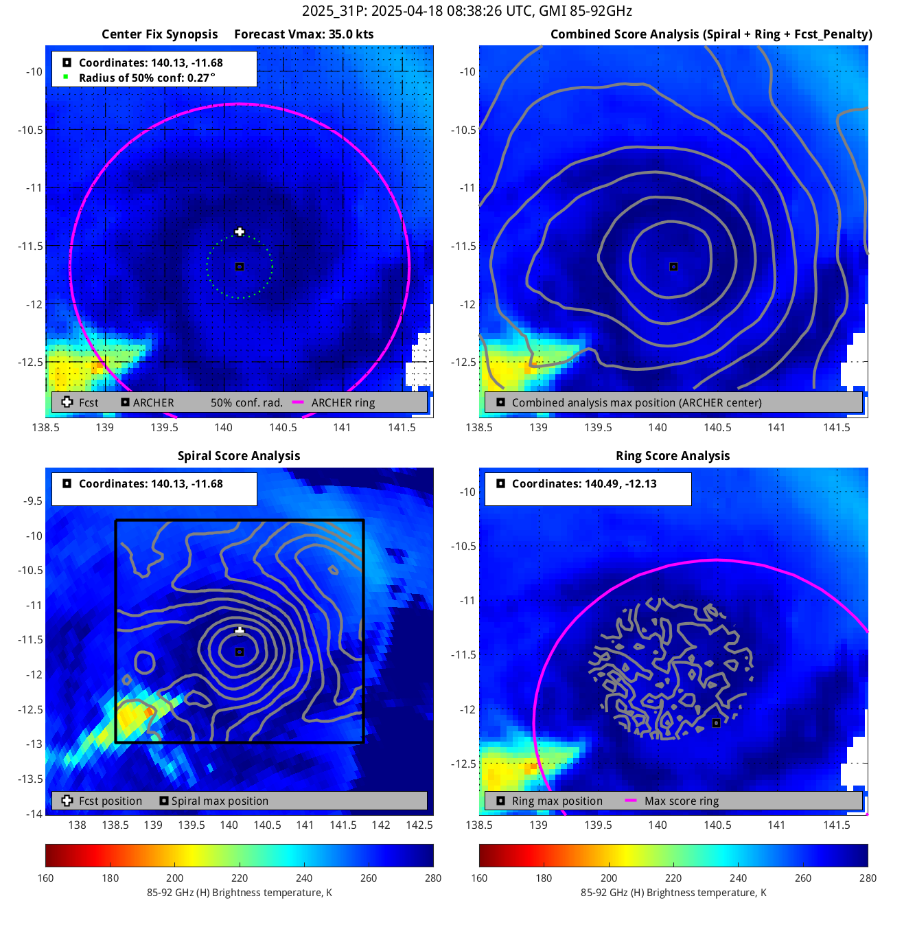
| 20250419 19:28:27 |
GMI |
85-92GHz |
30.0 |
-13.10 |
141.28 |
-13.08 |
141.31 |
0.40 |
1.14 |
0.70 |
10.9 |
| 20250419 19:28:27 * |
GMI |
37GHz |
30.0 |
-12.90 |
141.13 |
-12.88 |
141.15 |
0.33 |
0.94 |
1.30 |
*** |
|
|
|
 |
 |
| 20250419 18:09:58 |
SSMIS-18 |
85-92GHz |
30.0 |
-12.35 |
140.95 |
-12.37 |
140.95 |
0.41 |
1.17 |
3.00 |
0.7 |
|
|
|
 |
 |
|
|
|
 |
 |
|
|
|
 |
 |
|
|
|
 |
 |
|
|
|
 |
 |
| 20250418 21:22:03 * |
SSMIS-16 |
85-92GHz |
30.0 |
-12.95 |
140.64 |
-12.87 |
140.55 |
0.23 |
0.64 |
3.00 |
0.0 |
| 20250418 20:11:08 |
SSMIS-17 |
85-92GHz |
30.0 |
-12.68 |
140.56 |
-12.71 |
140.60 |
0.33 |
0.94 |
3.00 |
0.0 |
|
|
|
 |
 |
| 20250418 18:23:25 |
SSMIS-18 |
85-92GHz |
30.0 |
-12.26 |
140.49 |
-12.21 |
140.40 |
0.22 |
0.63 |
3.00 |
0.0 |
| 20250418 16:17:59 |
AMSR2 |
85-92GHz |
31.4 |
-12.28 |
140.87 |
-12.34 |
140.98 |
0.19 |
0.54 |
0.20 |
91.9 |
| 20250418 16:17:59 * |
AMSR2 |
37GHz |
31.4 |
-11.88 |
140.87 |
-11.94 |
140.98 |
0.15 |
0.44 |
0.50 |
*** |
|
|
|
 |
 |
|


