|
||

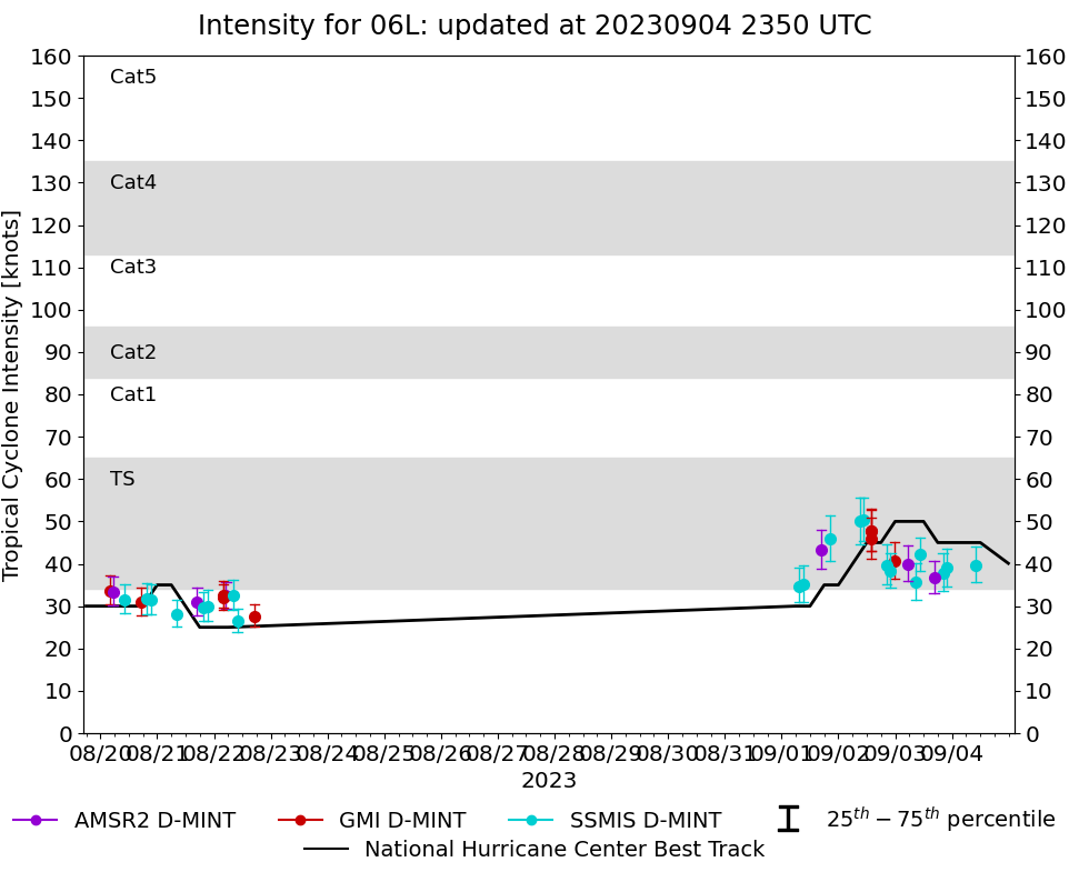 |
D-MINT HISTORY FILE for 2023_06L
| Date | Time | MW Sensor | MSLP | Vmax (30th-70th percentile average) | Vmax 25th percentile | Vmax 75th percentile | Image |
| 20230904 | 1012 UTC | SSMISF17 | 995 hPa | 40 kts | 36 kts | 44 kts |  |
| 20230903 | 2148 UTC | SSMISF17 | 1002 hPa | 39 kts | 35 kts | 44 kts |  |
| 20230903 | 2012 UTC | SSMISF16 | 1003 hPa | 38 kts | 34 kts | 43 kts |  |
| 20230903 | 1628 UTC | AMSR2 | 1003 hPa | 37 kts | 33 kts | 41 kts |  |
| 20230903 | 1028 UTC | SSMISF17 | 1000 hPa | 42 kts | 38 kts | 46 kts |  |
| 20230903 | 0852 UTC | SSMISF16 | 1004 hPa | 36 kts | 31 kts | 40 kts |  |
| 20230903 | 0528 UTC | AMSR2 | 1003 hPa | 40 kts | 36 kts | 44 kts |  |
| 20230902 | 2341 UTC | GMI | 1005 hPa | 41 kts | 37 kts | 45 kts |  |
| 20230902 | 2201 UTC | SSMISF17 | 1003 hPa | 38 kts | 34 kts | 43 kts |  |
| 20230902 | 2024 UTC | SSMISF16 | 1004 hPa | 40 kts | 35 kts | 44 kts |  |
| 20230902 | 1400 UTC | GMI | 1000 hPa | 46 kts | 41 kts | 51 kts |  |
| 20230902 | 1356 UTC | GMI | 1000 hPa | 48 kts | 43 kts | 53 kts |  |
| 20230902 | 1356 UTC | GMI | 1000 hPa | 48 kts | 43 kts | 53 kts |  |
| 20230902 | 1042 UTC | SSMISF17 | 997 hPa | 50 kts | 45 kts | 56 kts |  |
| 20230902 | 0906 UTC | SSMISF16 | 1000 hPa | 50 kts | 45 kts | 56 kts |  |
| 20230901 | 2037 UTC | SSMISF16 | 997 hPa | 46 kts | 41 kts | 51 kts |  |
| 20230901 | 1640 UTC | AMSR2 | 1006 hPa | 43 kts | 39 kts | 48 kts |  |
| 20230901 | 0918 UTC | SSMISF16 | 1003 hPa | 35 kts | 31 kts | 40 kts |  |
| 20230901 | 0726 UTC | SSMISF18 | 1003 hPa | 35 kts | 31 kts | 39 kts |  |
| 20230822 | 1716 UTC | GMI | 1007 hPa | 28 kts | 25 kts | 30 kts |  |
| 20230822 | 0952 UTC | SSMISF16 | 1007 hPa | 26 kts | 24 kts | 29 kts |  |
| 20230822 | 0800 UTC | SSMISF18 | 1006 hPa | 33 kts | 29 kts | 36 kts |  |
| 20230822 | 0508 UTC | AMSR2 | 1006 hPa | 32 kts | 29 kts | 36 kts |  |
| 20230822 | 0401 UTC | GMI | 1006 hPa | 32 kts | 29 kts | 35 kts |  |
| 20230822 | 0356 UTC | GMI | 1006 hPa | 33 kts | 30 kts | 36 kts |  |
| 20230821 | 2118 UTC | SSMISF16 | 1008 hPa | 30 kts | 27 kts | 34 kts |  |
| 20230821 | 1925 UTC | SSMISF18 | 1007 hPa | 30 kts | 26 kts | 33 kts |  |
| 20230821 | 1655 UTC | AMSR2 | 1007 hPa | 31 kts | 28 kts | 34 kts |  |
| 20230821 | 0813 UTC | SSMISF18 | 1007 hPa | 28 kts | 25 kts | 31 kts |  |
| 20230820 | 2132 UTC | SSMISF17 | 1007 hPa | 32 kts | 28 kts | 35 kts |  |
| 20230820 | 1938 UTC | SSMISF18 | 1006 hPa | 32 kts | 28 kts | 36 kts |  |
| 20230820 | 1726 UTC | GMI | 1008 hPa | 31 kts | 28 kts | 34 kts |  |
| 20230820 | 1020 UTC | SSMISF17 | 1007 hPa | 32 kts | 28 kts | 35 kts |  |
| 20230820 | 0519 UTC | AMSR2 | 1007 hPa | 33 kts | 30 kts | 37 kts |  |
| 20230820 | 0406 UTC | GMI | 1007 hPa | 34 kts | 30 kts | 37 kts |  |