|
||

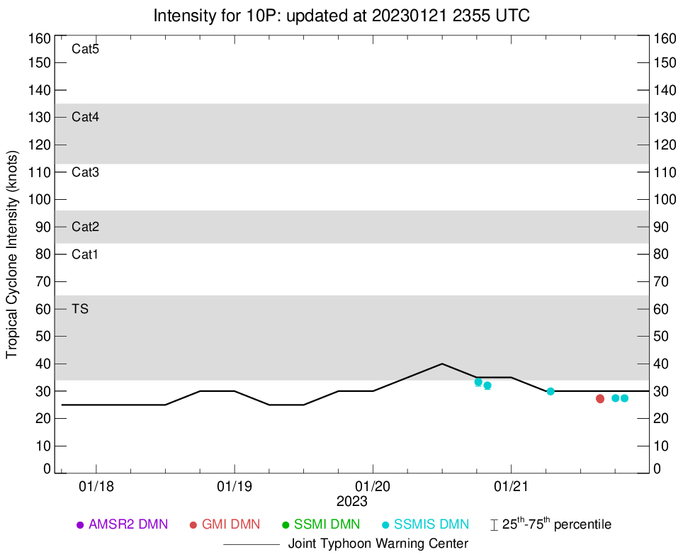 |
D-MINT HISTORY FILE for 2023_10P
| Date | Time | MW Sensor | MSLP | Vmax (30th-70th percentile average) | Vmax 25th percentile | Vmax 75th percentile | Image |
| 20230123 | 0754 UTC | SSMISF17 | NaN hPa | 0 kts | 0 kts | 0 kts |  |
| 20230123 | 0621 UTC | SSMISF16 | NaN hPa | 0 kts | 0 kts | 0 kts |  |
| 20230123 | 0558 UTC | SSMISF18 | NaN hPa | 0 kts | 0 kts | 0 kts |  |
| 20230122 | 1925 UTC | SSMISF17 | NaN hPa | 0 kts | 0 kts | 0 kts |  |
| 20230122 | 1751 UTC | SSMISF16 | NaN hPa | 0 kts | 0 kts | 0 kts |  |
| 20230122 | 0809 UTC | SSMISF17 | NaN hPa | 0 kts | 0 kts | 0 kts |  |
| 20230122 | 0634 UTC | SSMISF16 | NaN hPa | 0 kts | 0 kts | 0 kts |  |
| 20230122 | 0442 UTC | GMI | NaN hPa | 25 kts | 23 kts | 27 kts |  |
| 20230121 | 1938 UTC | SSMISF17 | NaN hPa | 25 kts | 24 kts | 27 kts |  |
| 20230121 | 1804 UTC | SSMISF16 | NaN hPa | 26 kts | 24 kts | 28 kts |  |
| 20230121 | 1526 UTC | GMI | NaN hPa | 27 kts | 25 kts | 30 kts |  |
| 20230121 | 1525 UTC | GMI | NaN hPa | 28 kts | 25 kts | 31 kts |  |
| 20230121 | 1525 UTC | GMI | NaN hPa | 28 kts | 25 kts | 31 kts |  |
| 20230121 | 1523 UTC | GMI | NaN hPa | 28 kts | 26 kts | 31 kts |  |
| 20230121 | 1522 UTC | GMI | NaN hPa | 28 kts | 26 kts | 31 kts |  |
| 20230121 | 0649 UTC | SSMISF16 | NaN hPa | 32 kts | 29 kts | 36 kts |  |
| 20230120 | 1952 UTC | SSMISF17 | NaN hPa | 33 kts | 29 kts | 37 kts |  |
| 20230120 | 1817 UTC | SSMISF16 | NaN hPa | 32 kts | 29 kts | 36 kts |  |