|
||

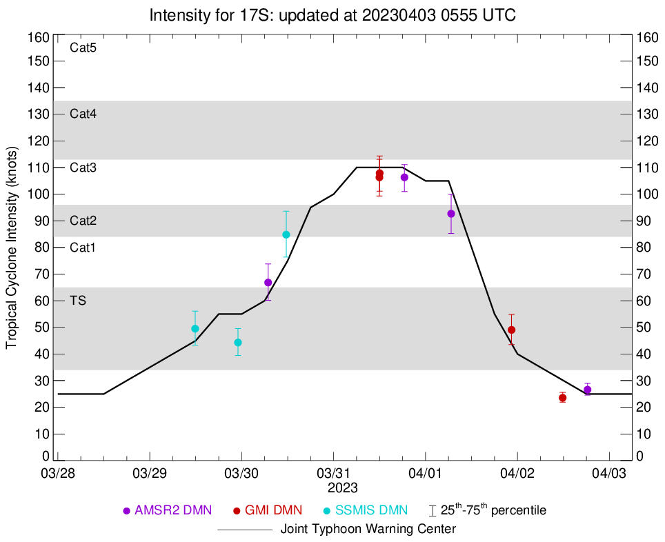 |
D-MINT HISTORY FILE for 2023_17S
| Date | Time | MW Sensor | MSLP | Vmax (30th-70th percentile average) | Vmax 25th percentile | Vmax 75th percentile | Image |
| 20230402 | 1817 UTC | AMSR2 | NaN hPa | 27 kts | 25 kts | 29 kts |  |
| 20230402 | 1147 UTC | GMI | NaN hPa | 24 kts | 22 kts | 26 kts |  |
| 20230401 | 2227 UTC | GMI | NaN hPa | 49 kts | 44 kts | 55 kts |  |
| 20230401 | 0641 UTC | AMSR2 | NaN hPa | 93 kts | 85 kts | 100 kts |  |
| 20230331 | 1829 UTC | AMSR2 | NaN hPa | 106 kts | 101 kts | 111 kts |  |
| 20230331 | 1201 UTC | GMI | NaN hPa | 108 kts | 101 kts | 114 kts |  |
| 20230331 | 1157 UTC | GMI | NaN hPa | 106 kts | 99 kts | 113 kts |  |
| 20230330 | 1137 UTC | SSMISF17 | NaN hPa | 85 kts | 76 kts | 94 kts |  |
| 20230330 | 0654 UTC | AMSR2 | NaN hPa | 67 kts | 60 kts | 74 kts |  |
| 20230329 | 2302 UTC | SSMISF17 | NaN hPa | 44 kts | 39 kts | 50 kts |  |
| 20230329 | 1151 UTC | SSMISF17 | NaN hPa | 49 kts | 43 kts | 56 kts |  |