|
||

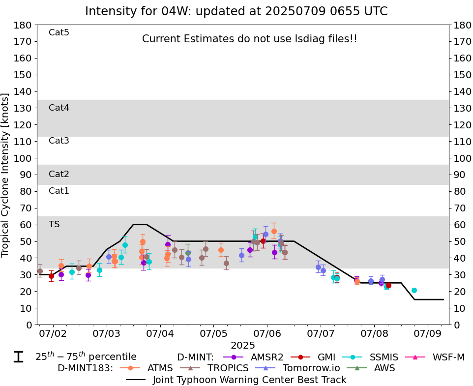 |
D-MINT HISTORY FILE for 2025_04W
| Date | Time | MW Sensor | MSLP | Vmax (30th-70th percentile average) | Vmax 25th percentile | Vmax 75th percentile | Image |
| 20250708 | 1746 UTC | SSMISF18 | NaN hPa | 21 kts | 20 kts | 21 kts |  |
| 20250708 | 0623 UTC | GMI | 996 hPa | 23 kts | 22 kts | 25 kts |  |
| 20250708 | 0525 UTC | SSMISF18 | 997 hPa | 23 kts | 21 kts | 24 kts |  |
| 20250708 | 0329 UTC | TMS03 | 997 hPa | 27 kts | 25 kts | 30 kts |  |
| 20250708 | 0307 UTC | AMSR2 | 996 hPa | 25 kts | 23 kts | 27 kts |  |
| 20250707 | 2222 UTC | TMS03 | 1003 hPa | 26 kts | 24 kts | 29 kts |  |
| 20250707 | 1610 UTC | ATMS-N21 | 1001 hPa | 26 kts | 24 kts | 28 kts |  |
| 20250707 | 1603 UTC | AMSR2 | 1000 hPa | 27 kts | 24 kts | 29 kts |  |
| 20250707 | 0710 UTC | SSMISF17 | 996 hPa | 28 kts | 25 kts | 31 kts |  |
| 20250707 | 0708 UTC | GMI | 995 hPa | 28 kts | 26 kts | 32 kts |  |
| 20250707 | 0538 UTC | SSMISF18 | 1000 hPa | 28 kts | 25 kts | 33 kts |  |
| 20250707 | 0057 UTC | TMS02 | 997 hPa | 33 kts | 30 kts | 36 kts |  |
| 20250706 | 2243 UTC | TMS03 | 997 hPa | 35 kts | 31 kts | 38 kts |  |
| 20250706 | 0755 UTC | TROPICS05 | 989 hPa | 43 kts | 39 kts | 47 kts |  |
| 20250706 | 0748 UTC | GMI | 986 hPa | 43 kts | 39 kts | 48 kts |  |
| 20250706 | 0617 UTC | TROPICS05 | 986 hPa | 49 kts | 45 kts | 54 kts |  |
| 20250706 | 0554 UTC | TMS03 | 986 hPa | 50 kts | 46 kts | 55 kts |  |
| 20250706 | 0551 UTC | SSMISF18 | 986 hPa | 48 kts | 44 kts | 53 kts |  |
| 20250706 | 0317 UTC | AMSR2 | 988 hPa | 44 kts | 39 kts | 48 kts |  |
| 20250706 | 0254 UTC | ATMS-NPP | 985 hPa | 56 kts | 52 kts | 61 kts |  |
| 20250705 | 2319 UTC | TMS03 | 986 hPa | 54 kts | 50 kts | 59 kts |  |
| 20250705 | 2203 UTC | GMI | 988 hPa | 50 kts | 46 kts | 55 kts |  |
| 20250705 | 1925 UTC | TROPICS03 | 987 hPa | 49 kts | 45 kts | 54 kts |  |
| 20250705 | 1831 UTC | SSMISF18 | 988 hPa | 53 kts | 48 kts | 58 kts |  |
| 20250705 | 1747 UTC | TROPICS03 | 986 hPa | 50 kts | 44 kts | 56 kts |  |
| 20250705 | 1617 UTC | AMSR2 | 990 hPa | 45 kts | 41 kts | 49 kts |  |
| 20250705 | 1224 UTC | TMS02 | 993 hPa | 42 kts | 38 kts | 46 kts |  |
| 20250705 | 0532 UTC | TROPICS05 | 993 hPa | 37 kts | 33 kts | 41 kts |  |
| 20250705 | 0312 UTC | ATMS-NPP | 995 hPa | 45 kts | 41 kts | 49 kts |  |
| 20250704 | 2018 UTC | TROPICS03 | 995 hPa | 45 kts | 41 kts | 50 kts |  |
| 20250704 | 1840 UTC | TROPICS03 | 998 hPa | 40 kts | 36 kts | 45 kts |  |
| 20250704 | 1240 UTC | TMS02 | 1000 hPa | 39 kts | 35 kts | 44 kts |  |
| 20250704 | 0941 UTC | TROPICS05 | 999 hPa | 40 kts | 36 kts | 45 kts |  |
| 20250704 | 0625 UTC | TROPICS05 | 997 hPa | 45 kts | 40 kts | 50 kts |  |
| 20250704 | 0330 UTC | ATMS-NPP | 1002 hPa | 42 kts | 38 kts | 47 kts |  |
| 20250704 | 0329 UTC | AMSR2 | 995 hPa | 48 kts | 43 kts | 54 kts |  |
| 20250704 | 0304 UTC | ATMS-N21 | 1001 hPa | 40 kts | 35 kts | 44 kts |  |
| 20250703 | 1900 UTC | SSMISF18 | 993 hPa | 38 kts | 33 kts | 43 kts |  |
| 20250703 | 1755 UTC | TROPICS03 | 993 hPa | 41 kts | 37 kts | 45 kts |  |
| 20250703 | 1630 UTC | AMSR2 | 997 hPa | 37 kts | 33 kts | 42 kts |  |
| 20250703 | 1613 UTC | ATMS-NPP | 993 hPa | 50 kts | 46 kts | 54 kts |  |
| 20250703 | 1548 UTC | ATMS- | 998 hPa | 40 kts | 36 kts | 45 kts |  |
| 20250703 | 1548 UTC | ATMS-N21 | 998 hPa | 40 kts | 36 kts | 45 kts |  |
| 20250703 | 0810 UTC | SSMISF16 | 996 hPa | 48 kts | 43 kts | 53 kts |  |
| 20250703 | 0633 UTC | SSMISF18 | 998 hPa | 40 kts | 36 kts | 45 kts |  |
| 20250703 | 0348 UTC | ATMS- | 997 hPa | 38 kts | 34 kts | 42 kts |  |
| 20250703 | 0323 UTC | ATMS-N21 | 992 hPa | 41 kts | 37 kts | 45 kts |  |
| 20250703 | 0322 UTC | ATMS- | 996 hPa | 38 kts | 34 kts | 42 kts |  |
| 20250703 | 0058 UTC | TMS02 | 993 hPa | 41 kts | 37 kts | 45 kts |  |
| 20250702 | 2052 UTC | SSMISF16 | 1000 hPa | 33 kts | 29 kts | 37 kts |  |
| 20250702 | 1607 UTC | ATMS-N21 | 1001 hPa | 35 kts | 31 kts | 39 kts |  |
| 20250702 | 1548 UTC | AMSR2 | 1002 hPa | 30 kts | 26 kts | 33 kts |  |
| 20250702 | 1129 UTC | TROPICS05 | 1000 hPa | 34 kts | 30 kts | 38 kts |  |
| 20250702 | 0823 UTC | SSMISF16 | 1002 hPa | 32 kts | 27 kts | 36 kts |  |
| 20250702 | 0341 UTC | ATMS-N21 | 1001 hPa | 35 kts | 32 kts | 39 kts |  |
| 20250702 | 0340 UTC | AMSR2 | 1004 hPa | 30 kts | 27 kts | 34 kts |  |
| 20250701 | 2313 UTC | GMI | 1002 hPa | 29 kts | 26 kts | 33 kts |  |
| 20250701 | 1805 UTC | TROPICS03 | 1002 hPa | 32 kts | 29 kts | 36 kts |  |
| 20250701 | 1223 UTC | TROPICS05 | 1006 hPa | 26 kts | 24 kts | 29 kts |  |
| 20250701 | 1208 UTC | TMS02 | 1006 hPa | 27 kts | 24 kts | 30 kts |  |