|
Current Intensity Estimates
|
ADT
|
| Date |
Time |
Vmax |
MSLP |
| 15Feb2026 |
0530UTC |
55 kts |
986 hPa |
| Scene |
CI# |
FT# |
AdjT# |
RawT# |
Eye T |
Cloud T |
| UNIFRM |
3.5 |
3.5 |
3.5 |
3.5 |
-62.83C |
-64.37C |
|
|
|
|
AiDT
|
| Date |
Time |
Vmax |
|
| 15Feb2026 |
0530UTC |
54 kts |
|
|
|
|
|
DPRINT
|
| Date |
Time |
Vmax |
MSLP |
| 15Feb2026 |
0530UTC |
76 kts |
970 hPa |
| Vmax 25% |
Vmax 75% |
|
|
| 68 kts |
83 kts |
|
|
|
|
|
|
DMINT
|
| Date |
Time |
Vmax |
MSLP |
| 15Feb2026 |
0404UTC |
77 kts |
968 hPa |
| Vmax 25% |
Vmax 75% |
MW Instr. |
|
| 70 kts |
84 kts |
SSMISF16 |
|
|
|
| Date |
Time |
Vmax |
MSLP |
| 15Feb2026 |
0327UTC |
79 kts |
968 hPa |
| Vmax 25% |
Vmax 75% |
MW Instr. |
|
| 72 kts |
86 kts |
WSFM01 |
|
15Feb2026 |
0405UTC |
-26.80S |
39.38E |
| Satellite |
Sensor |
Eye Diameter |
Eye Cert % |
| SSMIS-16 |
85-92GHz |
2.80 deg |
9.7% |
|
|
|
|
TC Structure
|
MPERC
|
| Date |
Time |
Prob. ERC onset
Full Model |
Prob. ERC onset
V-based |
| 15Feb2026 |
0400UTC |
1% |
7% |
|
|
|
|
MIMIC-TPW
|
|
|
|
MIMIC-TC
|
|
|
|
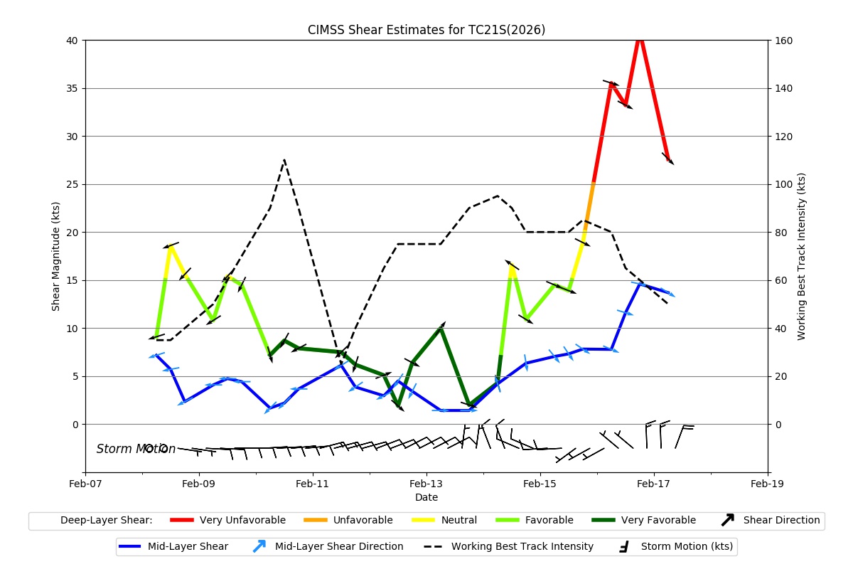
Shear Analysis
|
| Date |
Time |
Shear Magnitude
|
Shear Direction
|
| 15Feb2026 |
000UTC |
13 kts |
301 deg |
| Deep-layer vertical wind shear interpolated to storm center derived from the CIMSS AMV-aided analyses with vortex removed |
|
|
|
|
TC-Scale AMVs
|
|
|
|