|
Current Intensity Estimates
|
ADT
|
| Date |
Time |
Vmax |
MSLP |
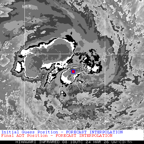
| 24Mar2026 |
0810UTC |
39 kts |
997 hPa |
| Scene |
CI# |
FT# |
AdjT# |
RawT# |
Eye T |
Cloud T |
| UNIFRM |
2.7 |
2.7 |
2.9 |
3.1 |
-77.15C |
-67.07C |
|
|
|
|
AiDT
|
| Date |
Time |
Vmax |
|
| 24Mar2026 |
0810UTC |
33 kts |
|
|
|
|
|
DPRINT
|
| Date |
Time |
Vmax |
MSLP |
| 24Mar2026 |
0810UTC |
41 kts |
992 hPa |
| Vmax 25% |
Vmax 75% |
|
|
| 36 kts |
46 kts |
|
|
|
|
|
|
DMINT
|
| Date |
Time |
Vmax |
MSLP |
| 24Mar2026 |
0544UTC |
43 kts |
996 hPa |
| Vmax 25% |
Vmax 75% |
MW Instr. |
|
| 37 kts |
49 kts |
ATMS-N21 |
|
|
|
| Date |
Time |
Vmax |
MSLP |
| 24Mar2026 |
0503UTC |
39 kts |
993 hPa |
| Vmax 25% |
Vmax 75% |
MW Instr. |
|
| 34 kts |
45 kts |
AMSR2 |
|
24Mar2026 |
0503UTC |
-15.76S |
124.02E |
| Satellite |
Sensor |
Eye Diameter |
Eye Cert % |
| AMSR2 |
85-92GHz |
1.30 deg |
1.5% |
|
|
|
|
TC Structure
|
MPERC
|
| Date |
Time |
Prob. ERC onset
Full Model |
Prob. ERC onset
V-based |
| 24Mar2026 |
0500UTC |
0% |
0% |
|
|
|
|
MIMIC-TPW
|
|
|
|
MIMIC-TC
|
|
|
|
Shear Analysis
|
| Date |
Time |
Shear Magnitude
|
Shear Direction
|
| 24Mar2026 |
600UTC |
15 kts |
97 deg |
| Deep-layer vertical wind shear interpolated to storm center derived from the CIMSS AMV-aided analyses with vortex removed |
|
|
|
|
TC-Scale AMVs
|
|
|
|