|
Current Intensity Estimates
|
ADT
|
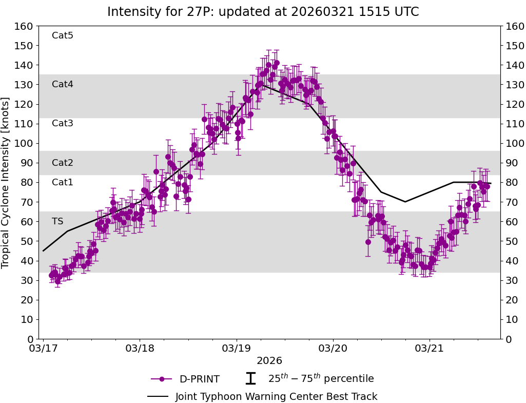
| Date |
Time |
Vmax |
MSLP |
| 25Mar2026 |
0800UTC |
99 kts |
954 hPa |
| Scene |
CI# |
FT# |
AdjT# |
RawT# |
Eye T |
Cloud T |
| EYE |
5.4 |
5.4 |
5.7 |
6.4 |
-10.71C |
-75.90C |
|
|
|
|
AiDT
|
| Date |
Time |
Vmax |
|
| 25Mar2026 |
0800UTC |
88 kts |
|
|
|
|
|
DPRINT
|
| Date |
Time |
Vmax |
MSLP |
| 25Mar2026 |
0800UTC |
75 kts |
966 hPa |
| Vmax 25% |
Vmax 75% |
|
|
| 69 kts |
82 kts |
|
|
|
|
|
|
DMINT
|
| Date |
Time |
Vmax |
MSLP |
| 25Mar2026 |
0616UTC |
79 kts |
966 hPa |
| Vmax 25% |
Vmax 75% |
MW Instr. |
|
| 74 kts |
86 kts |
ATMS-N20 |
|
|
|
| Date |
Time |
Vmax |
MSLP |
| 25Mar2026 |
0525UTC |
75 kts |
968 hPa |
| Vmax 25% |
Vmax 75% |
MW Instr. |
|
| 69 kts |
81 kts |
ATMS-N21 |
|
MPERC
|
| Date |
Time |
Prob. ERC onset
Full Model |
Prob. ERC onset
V-based |
| 24Mar2026 |
2200UTC |
0% |
0% |
|
|
|
|
MIMIC-TPW
|
|
|
|
MIMIC-TC
|
|
|
|
Shear Analysis
|
| Date |
Time |
Shear Magnitude
|
Shear Direction
|
| 25Mar2026 |
600UTC |
14 kts |
80 deg |
| Deep-layer vertical wind shear interpolated to storm center derived from the CIMSS AMV-aided analyses with vortex removed |
|
|
|
|
TC-Scale AMVs
|
|
|
|