|
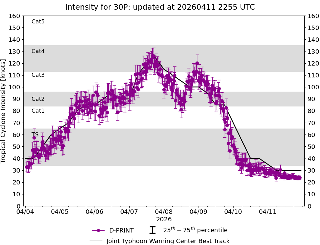
Current Intensity Estimates
|
ADT
|
| Date |
Time |
Vmax |
MSLP |
| 11Apr2026 |
0610UTC |
25 kts |
1005 hPa |
| Scene |
CI# |
FT# |
AdjT# |
RawT# |
Eye T |
Cloud T |
| SHEAR |
1.5 |
1.5 |
1.5 |
1.5 |
17.05C |
2.17C |
|
|
|
|
AiDT
|
| Date |
Time |
Vmax |
|
| 11Apr2026 |
0610UTC |
31 kts |
|
|
|
|
|
DPRINT
|
| Date |
Time |
Vmax |
MSLP |
| 11Apr2026 |
0610UTC |
28 kts |
999 hPa |
| Vmax 25% |
Vmax 75% |
|
|
| 26 kts |
31 kts |
|
|
|
|
|
|
DMINT
|
| Date |
Time |
Vmax |
MSLP |
| 11Apr2026 |
0326UTC |
27 kts |
1000 hPa |
| Vmax 25% |
Vmax 75% |
MW Instr. |
|
| 24 kts |
30 kts |
ATMS-N21 |
|
|
|
| Date |
Time |
Vmax |
MSLP |
| 11Apr2026 |
0312UTC |
26 kts |
1000 hPa |
| Vmax 25% |
Vmax 75% |
MW Instr. |
|
| 23 kts |
30 kts |
AMSR2 |
|
11Apr2026 |
0546UTC |
-8.28S |
155.13E |
| Satellite |
Sensor |
Eye Diameter |
Eye Cert % |
| SSMIS-18 |
85-92GHz |
2.70 deg |
0.7% |
|
|
|
|
TC Structure
|
MPERC
|
| Date |
Time |
Prob. ERC onset
Full Model |
Prob. ERC onset
V-based |
| 11Apr2026 |
0500UTC |
0% |
0% |
|
|
|
|
MIMIC-TPW
|
|
|
|
MIMIC-TC
|
|
|
|
Shear Analysis
|
| Date |
Time |
Shear Magnitude
|
Shear Direction
|
| 11Apr2026 |
000UTC |
13 kts |
82 deg |
| Deep-layer vertical wind shear interpolated to storm center derived from the CIMSS AMV-aided analyses with vortex removed |
|
|
|
|
TC-Scale AMVs
|
|
|
|