|
Current Intensity Estimates
|
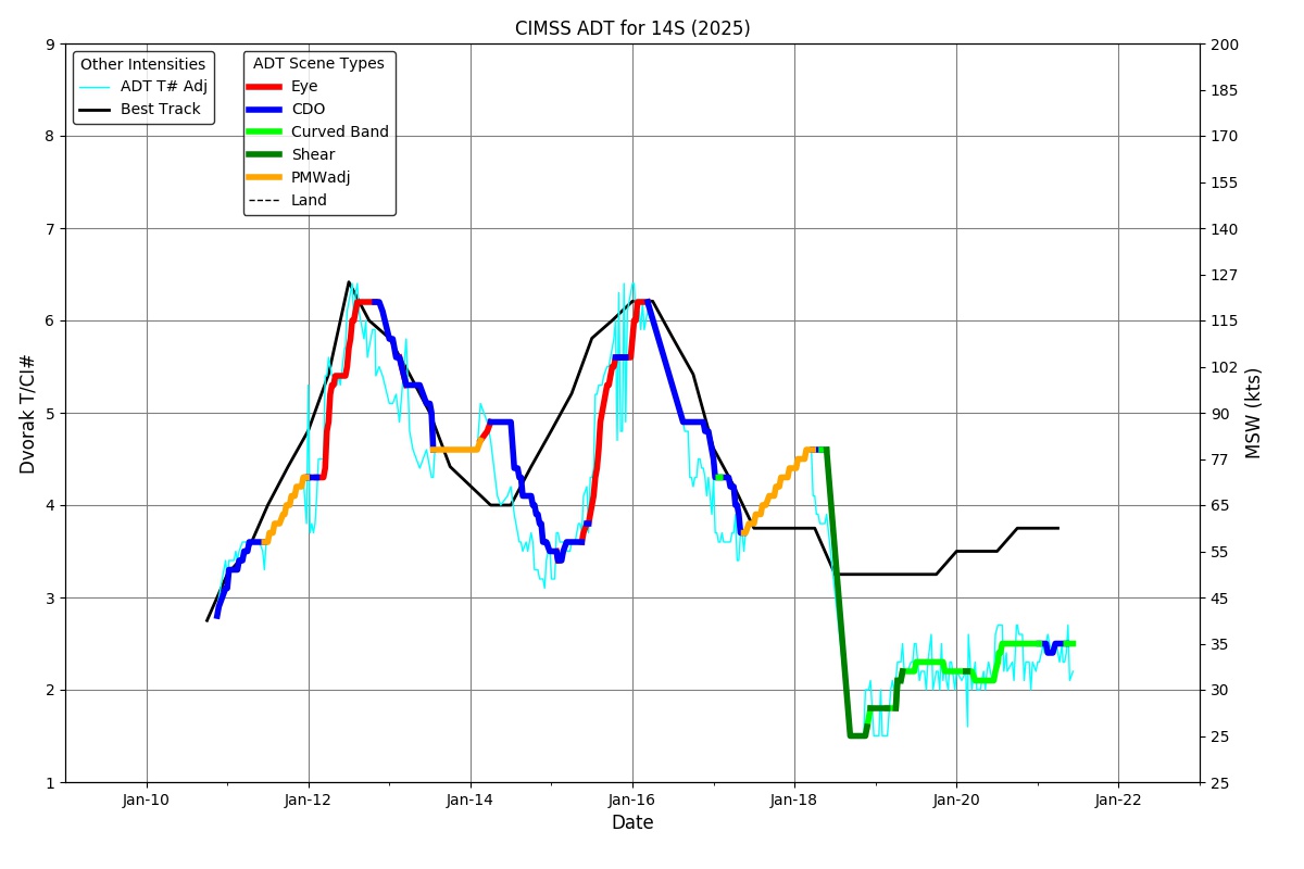
ADT
|
| Date |
Time |
Vmax |
MSLP |
| 13Jan2026 |
0100UTC |
109 kts |
955 hPa |
| Scene |
CI# |
FT# |
AdjT# |
RawT# |
Eye T |
Cloud T |
| UNIFRM |
5.8 |
5.2 |
5.1 |
4.8 |
-73.85C |
-75.76C |
|
|
|
|
AiDT
|
| Date |
Time |
Vmax |
|
| 13Jan2026 |
0100UTC |
106 kts |
|
|
|
|
|
DPRINT
|
| Date |
Time |
Vmax |
MSLP |
| 13Jan2026 |
0100UTC |
117 kts |
943 hPa |
| Vmax 25% |
Vmax 75% |
|
|
| 111 kts |
122 kts |
|
|
|
|
|
|
DMINT
|
| Date |
Time |
Vmax |
MSLP |
| 13Jan2026 |
0129UTC |
116 kts |
938 hPa |
| Vmax 25% |
Vmax 75% |
MW Instr. |
|
| 109 kts |
122 kts |
SSMISF16 |
|
|
|
| Date |
Time |
Vmax |
MSLP |
| 13Jan2026 |
0059UTC |
116 kts |
940 hPa |
| Vmax 25% |
Vmax 75% |
MW Instr. |
|
| 109 kts |
122 kts |
WSFM01 |
|
13Jan2026 |
0130UTC |
-17.07S |
78.02E |
| Satellite |
Sensor |
Eye Diameter |
Eye Cert % |
| SSMIS-16 |
85-92GHz |
0.10 deg |
77.6% |
|
|
|
|
TC Structure
|
MPERC
|
| Date |
Time |
Prob. ERC onset
Full Model |
Prob. ERC onset
V-based |
| 13Jan2026 |
0100UTC |
70% |
19% |
|
|
|
|
MIMIC-TPW
|
|
|
|
MIMIC-TC
|
|
|
|
Shear Analysis
|
| Date |
Time |
Shear Magnitude
|
Shear Direction
|
| 13Jan2026 |
000UTC |
N/A kts |
N/A deg |
| Deep-layer vertical wind shear interpolated to storm center derived from the CIMSS AMV-aided analyses with vortex removed |
|
|
|
|
TC-Scale AMVs
|
|
|
|