|
Current Intensity Estimates
|
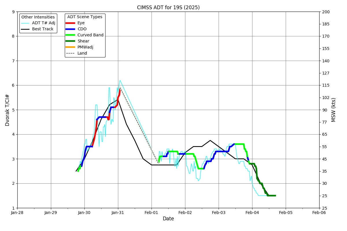
ADT
|
| Date |
Time |
Vmax |
MSLP |
| 04Feb2026 |
0030UTC |
41 kts |
999 hPa |
| Scene |
CI# |
FT# |
AdjT# |
RawT# |
Eye T |
Cloud T |
| SHEAR |
2.8 |
2.1 |
1.9 |
1.8 |
15.98C |
5.58C |
|
|
|
|
AiDT
|
| Date |
Time |
Vmax |
|
| 04Feb2026 |
0030UTC |
39 kts |
|
|
|
|
|
DPRINT
|
| Date |
Time |
Vmax |
MSLP |
| 04Feb2026 |
0030UTC |
36 kts |
998 hPa |
| Vmax 25% |
Vmax 75% |
|
|
| 32 kts |
41 kts |
|
|
|
|
|
|
DMINT
|
| Date |
Time |
Vmax |
MSLP |
| 04Feb2026 |
0024UTC |
31 kts |
1000 hPa |
| Vmax 25% |
Vmax 75% |
MW Instr. |
|
| 28 kts |
35 kts |
SSMISF18 |
|
|
|
| Date |
Time |
Vmax |
MSLP |
| 03Feb2026 |
2148UTC |
35 kts |
995 hPa |
| Vmax 25% |
Vmax 75% |
MW Instr. |
|
| 31 kts |
39 kts |
AMSR2 |
|
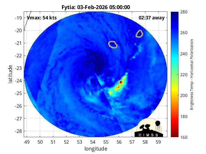
04Feb2026 |
0026UTC |
-23.42S |
54.72E |
| Satellite |
Sensor |
Eye Diameter |
Eye Cert % |
| SSMIS-18 |
85-92GHz |
2.00 deg |
2.0% |
|
|
|
|
TC Structure
|
MPERC
|
| Date |
Time |
Prob. ERC onset
Full Model |
Prob. ERC onset
V-based |
| 04Feb2026 |
0000UTC |
0% |
0% |
|
|
|
|
MIMIC-TPW
|
|
|
|
MIMIC-TC
|
|
|
|
Shear Analysis
|
| Date |
Time |
Shear Magnitude
|
Shear Direction
|
| 04Feb2026 |
000UTC |
37 kts |
286 deg |
| Deep-layer vertical wind shear interpolated to storm center derived from the CIMSS AMV-aided analyses with vortex removed |
|
|
|
|
TC-Scale AMVs
|
|
|
|