|
Current Intensity Estimates
|
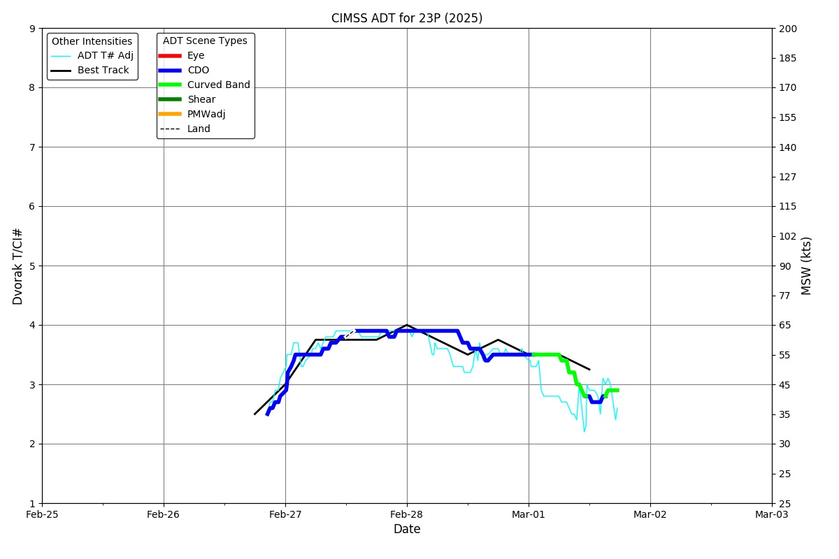
ADT
|
| Date |
Time |
Vmax |
MSLP |
| 28Feb2026 |
1720UTC |
55 kts |
985 hPa |
| Scene |
CI# |
FT# |
AdjT# |
RawT# |
Eye T |
Cloud T |
| UNIFRM |
3.5 |
3.5 |
3.6 |
3.6 |
-73.95C |
-73.88C |
|
|
|
|
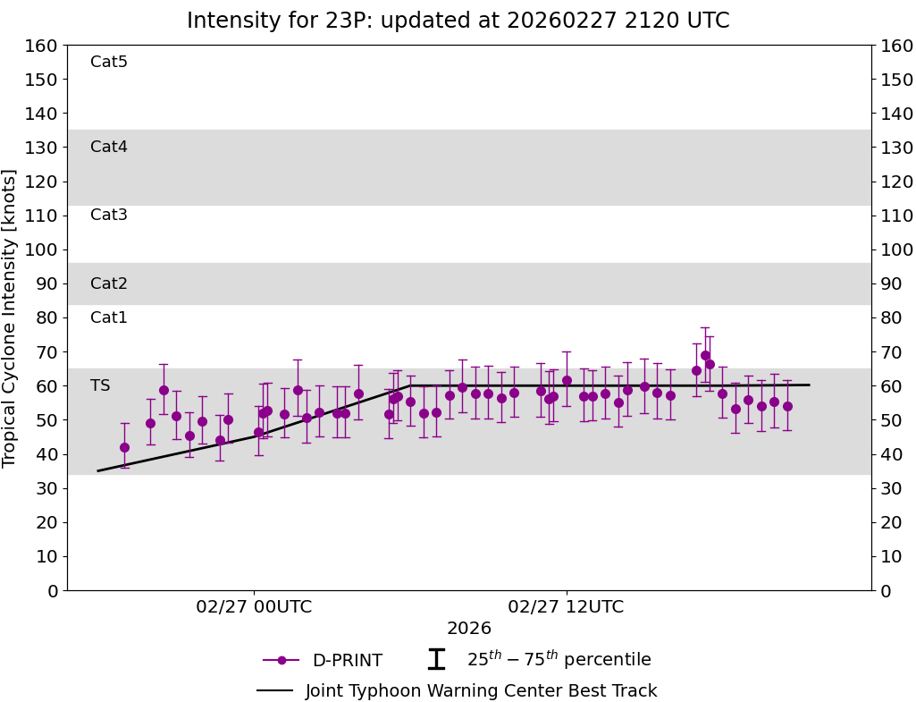
AiDT
|
| Date |
Time |
Vmax |
|
| 28Feb2026 |
1720UTC |
62 kts |
|
|
|
|
|
DPRINT
|
| Date |
Time |
Vmax |
MSLP |
| 28Feb2026 |
1720UTC |
58 kts |
985 hPa |
| Vmax 25% |
Vmax 75% |
|
|
| 52 kts |
65 kts |
|
|
|
|
|
|
DMINT
|
| Date |
Time |
Vmax |
MSLP |
| 28Feb2026 |
1331UTC |
49 kts |
991 hPa |
| Vmax 25% |
Vmax 75% |
MW Instr. |
|
| 43 kts |
55 kts |
ATMS-N20 |
|
|
|
| Date |
Time |
Vmax |
MSLP |
| 28Feb2026 |
1327UTC |
49 kts |
987 hPa |
| Vmax 25% |
Vmax 75% |
MW Instr. |
|
| 43 kts |
56 kts |
AMSR2 |
|
MPERC
|
| Date |
Time |
Prob. ERC onset
Full Model |
Prob. ERC onset
V-based |
| 28Feb2026 |
1100UTC |
4% |
3% |
|
|
|
|
MIMIC-TPW
|
|
|
|
MIMIC-TC
|
|
|
|
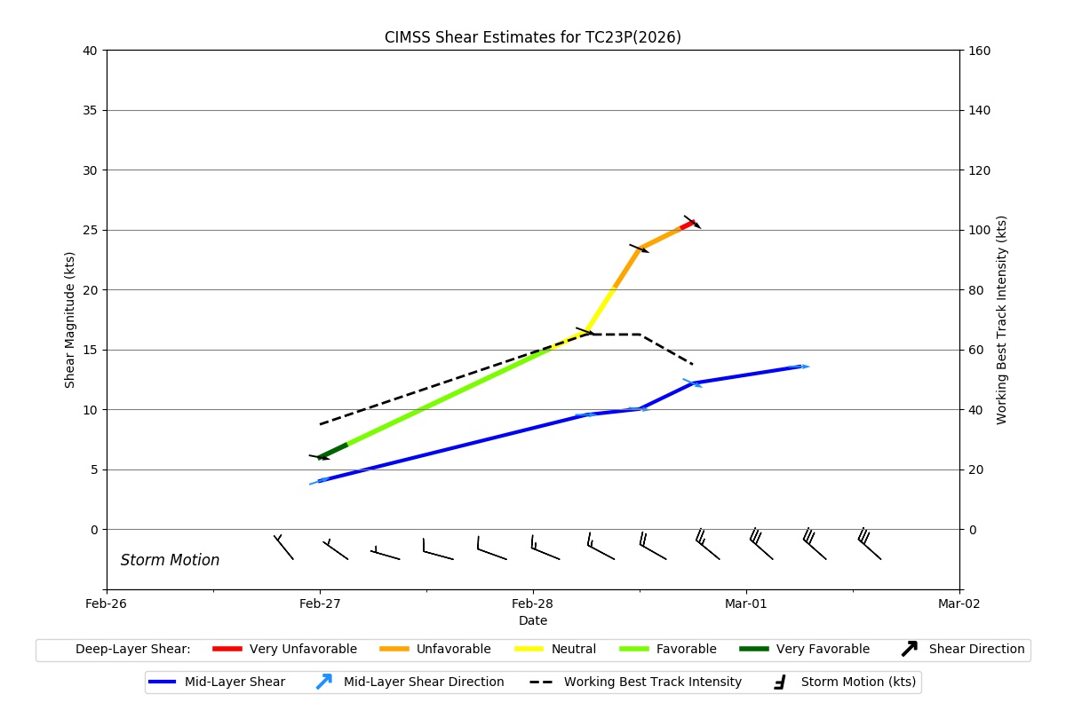
Shear Analysis
|
| Date |
Time |
Shear Magnitude
|
Shear Direction
|
| 28Feb2026 |
1200UTC |
23 kts |
293 deg |
| Deep-layer vertical wind shear interpolated to storm center derived from the CIMSS AMV-aided analyses with vortex removed |
|
|
|
|
TC-Scale AMVs
|
|
|
|