|
Current Intensity Estimates
|
ADT
|
| Date |
Time |
Vmax |
MSLP |
| 09Feb2026 |
2100UTC |
57 kts |
995 hPa |
| Scene |
CI# |
FT# |
AdjT# |
RawT# |
Eye T |
Cloud T |
| UNIFRM |
3.6 |
3.6 |
3.7 |
3.7 |
-39.47C |
-70.28C |
|
|
|
|
AiDT
|
| Date |
Time |
Vmax |
|
| 09Feb2026 |
2100UTC |
58 kts |
|
|
|
|
|
DPRINT
|
| Date |
Time |
Vmax |
MSLP |
| 09Feb2026 |
2100UTC |
82 kts |
969 hPa |
| Vmax 25% |
Vmax 75% |
|
|
| 75 kts |
89 kts |
|
|
|
|
|
|
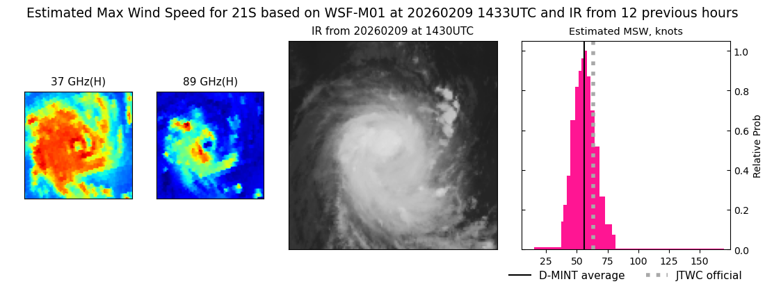
DMINT
|
| Date |
Time |
Vmax |
MSLP |
| 09Feb2026 |
1433UTC |
56 kts |
984 hPa |
| Vmax 25% |
Vmax 75% |
MW Instr. |
|
| 50 kts |
63 kts |
WSFM01 |
|
|
|
|
|
MW Sounders
|
| Date |
Time |
Vmax |
MSLP |
| 09Feb2026 |
1003UTC |
57 kts |
987 hPa |
|
|
|
|
SATCON
|
| Date |
Time |
Vmax |
MSLP |
| 09Feb2026 |
2100UTC |
64 kts |
986 hPa |
| Consensus Members |
| 2 (ADT+Sounders) |
|
|
|