Return to Homepage
Cooperative Institute for Meteorological Satellite Studies / University of Wisconsin-Madison
Tropical Cyclone 22W
Latest Real-Time CIMSS Product Summary
Current Time :    
Click on product name to access the full product homepage for each specific storm
Mouse over images to enlarge; click to view in window
Product Latency Color Code : Less than 3 hours old   3 - 6 hours old   6 - 12 hours old   Greater than 12 hours old   Not Available
Current Intensity Estimates
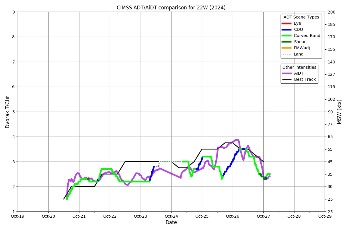
 ADT
Date Time Vmax MSLP
25Oct2024 2300UTC 43 kts 993 hPa
Scene CI# FT# AdjT# RawT# Eye T Cloud T
UNIFRM 2.9 2.9 3.2 3.2 -77.27C -72.64C
AiDT
Date Time Vmax  
25Oct2024 2300UTC 59 kts  
 
DPRINT
Date Time Vmax MSLP
25Oct2024 2300UTC 62 kts NaN hPa
Vmax 25% Vmax 75%    
54 kts 70 kts    
DMINT
Date Time Vmax MSLP
25Oct2024 1802UTC 61 kts NaN hPa
Vmax 25% Vmax 75% MW Instr.  
55 kts 68 kts ATMS-NPP  
MW Sounders
Date Time Vmax MSLP
25Oct2024 1802UTC 69 kts 961 hPa
  Satellite FOV  
  ATMS 9  
SATCON
Date Time Vmax MSLP
25Oct2024 2130UTC 66 kts 972 hPa
Consensus Members
2 (ADT+Sounders)

RI Forecast AI-RI
Date Time Current Vmax Current MPI
N/A N/AUTC N/A kts N/A kts
20kt/12h 25kt/24h 30kt/24h 35kt/24h 40kt/24h 45kt/36h 55kt/48h 65kt/72h
N/A% N/A% N/A% N/A% N/A% N/A% N/A% N/A%

Position Estimates ARCHER
Date Time Latitude Longitude
25Oct2024 1251UTC 17.10N 116.25E
Satellite Sensor Eye Diameter Eye Cert %
Metop-A ASCAT --- deg ---%

TC Structure MPERC
Date Time Prob. ERC onset
Full Model
Prob. ERC onset
V-based
25Oct2024 2200UTC 0% 0%
 
MIMIC-TPW  
MIMIC-TC  
Shear Analysis
Date Time Shear Magnitude
Shear Direction
25Oct2024 1800UTC 26 kts 90 deg
Deep-layer vertical wind shear interpolated to storm center derived from the CIMSS AMV-aided analyses with vortex removed
TC-Scale AMVs