Return to Homepage
Cooperative Institute for Meteorological Satellite Studies / University of Wisconsin-Madison
Tropical Cyclone 31P (31p)
Latest Real-Time CIMSS Product Summary
Current Time :    
NHC/JTWC
Click on product name to access the full product homepage for each specific storm
Mouse over images to enlarge; click to view in window
Product Latency Color Code : Less than 3 hours old   3 - 6 hours old   6 - 12 hours old   Greater than 12 hours old   Not Available
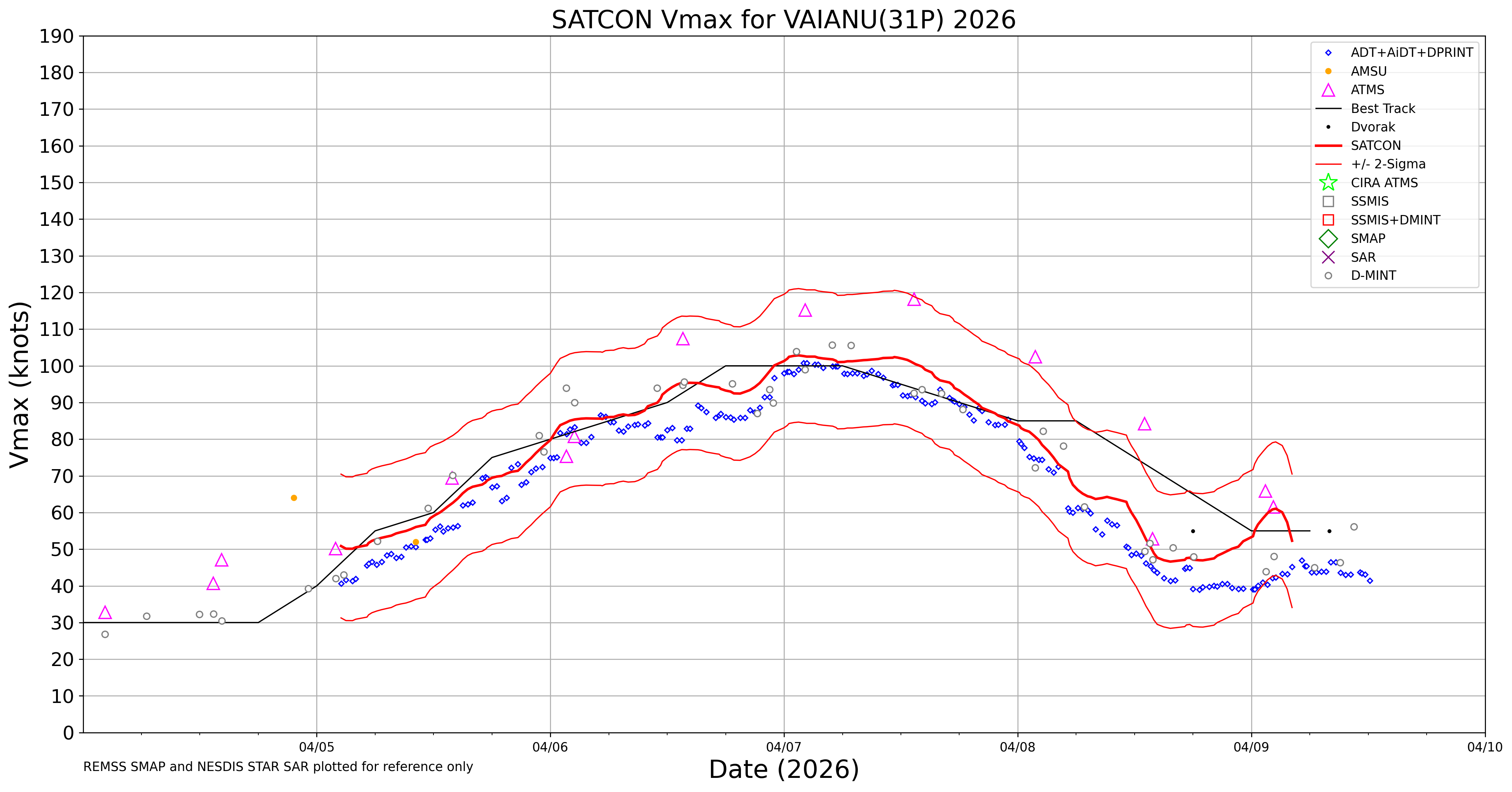
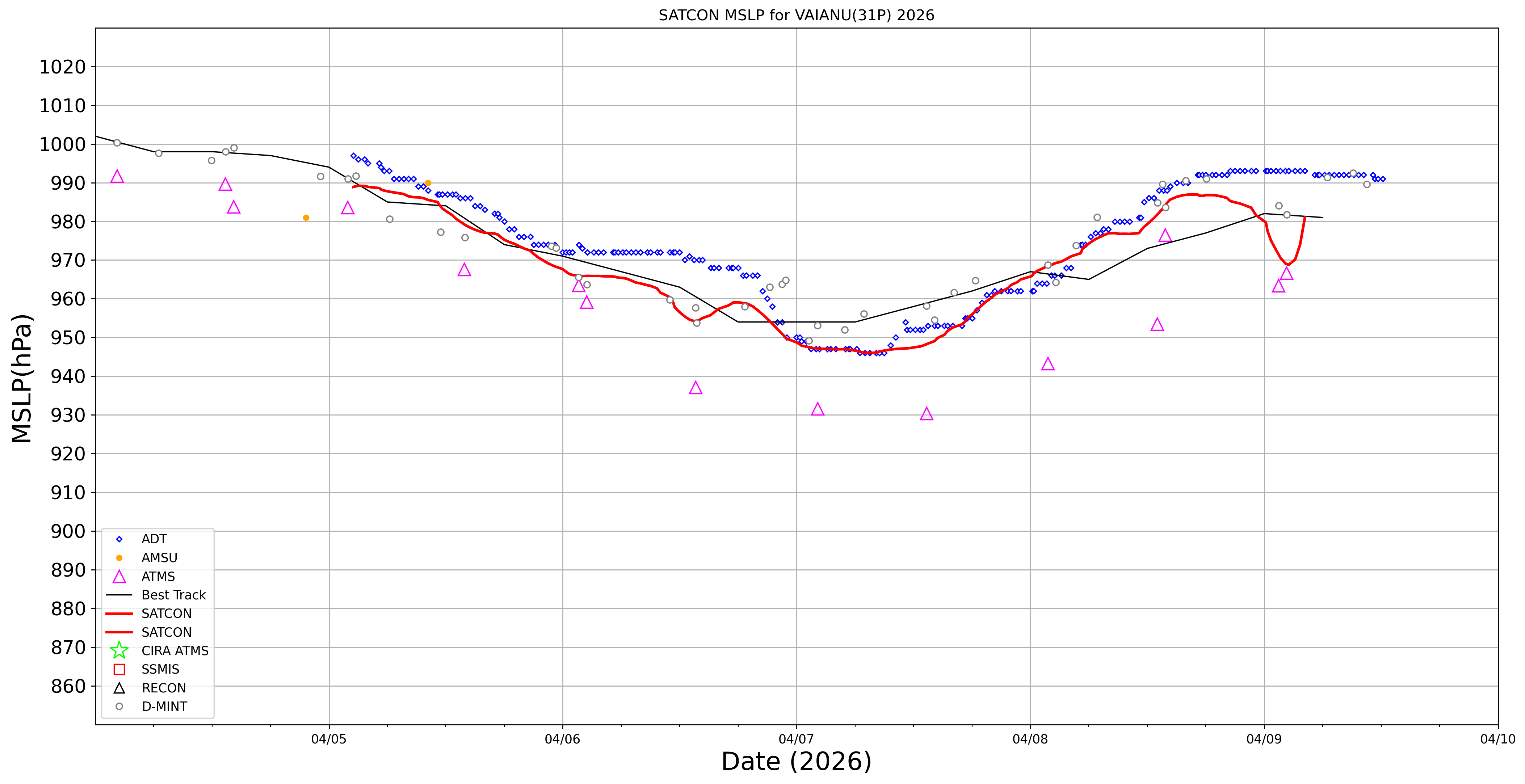
Current Intensity Estimates ADT
Date Time Vmax MSLP
10Apr2026 0500UTC 41 kts 988 hPa
Scene CI# FT# AdjT# RawT# Eye T Cloud T
CRVBND 2.8 2.8 2.7 2.7 12.52C -17.41C
AiDT
Date Time Vmax  
10Apr2026 0500UTC 48 kts  
 
DPRINT
Date Time Vmax MSLP
10Apr2026 0500UTC 50 kts 994 hPa
Vmax 25% Vmax 75%    
44 kts 56 kts    
DMINT
Date Time Vmax MSLP
10Apr2026 0158UTC 49 kts 989 hPa
Vmax 25% Vmax 75% MW Instr.  
44 kts 54 kts ATMS-N21  
MW Sounders
Date Time Vmax MSLP
09Apr2026 0216UTC 62 kts 967 hPa
  Satellite FOV  
  NOAA-21 83  
SATCON
Date Time Vmax MSLP
10Apr2026 0230UTC 59 kts 971 hPa
Consensus Members
2 (ADT+Sounders)

RI Forecast AI-RI
Date Time Current Vmax Current MPI
10Apr2026 0000UTC 55 kts 9999 kts
20kt/12h 25kt/24h 30kt/24h 35kt/24h 40kt/24h 45kt/36h 55kt/48h 65kt/72h
0.1% 0.7% 0.1% 0.2% 0.1% 0.1% 0.6% 0.0%

Position Estimates ARCHER
Date Time Latitude Longitude
09Apr2026 1815UTC -28.68S 179.10E
Satellite Sensor Eye Diameter Eye Cert %
SSMIS-17 85-92GHz 1.30 deg 56.5%

TC Structure MPERC
Date Time Prob. ERC onset
Full Model
Prob. ERC onset
V-based
09Apr2026 1800UTC 0% 0%
 
MIMIC-TPW  
MIMIC-TC  
Shear Analysis
Date Time Shear Magnitude
Shear Direction
10Apr2026 000UTC 21 kts 348 deg
Deep-layer vertical wind shear interpolated to storm center derived from the CIMSS AMV-aided analyses with vortex removed
TC-Scale AMVs