|
Current Intensity Estimates
|
ADT
|
| Date |
Time |
Vmax |
MSLP |
| 22Aug2025 |
1840UTC |
49 kts |
976 hPa |
| Scene |
CI# |
FT# |
AdjT# |
RawT# |
Eye T |
Cloud T |
| SHEAR |
3.2 |
3.2 |
3.4 |
3.4 |
9.61C |
-18.60C |
|
|
|
|
AiDT
|
| Date |
Time |
Vmax |
|
| 22Aug2025 |
1840UTC |
48 kts |
|
|
|
|
|
DPRINT
|
| Date |
Time |
Vmax |
MSLP |
| 22Aug2025 |
1840UTC |
58 kts |
979 hPa |
| Vmax 25% |
Vmax 75% |
|
|
| 52 kts |
64 kts |
|
|
|
|
|
|
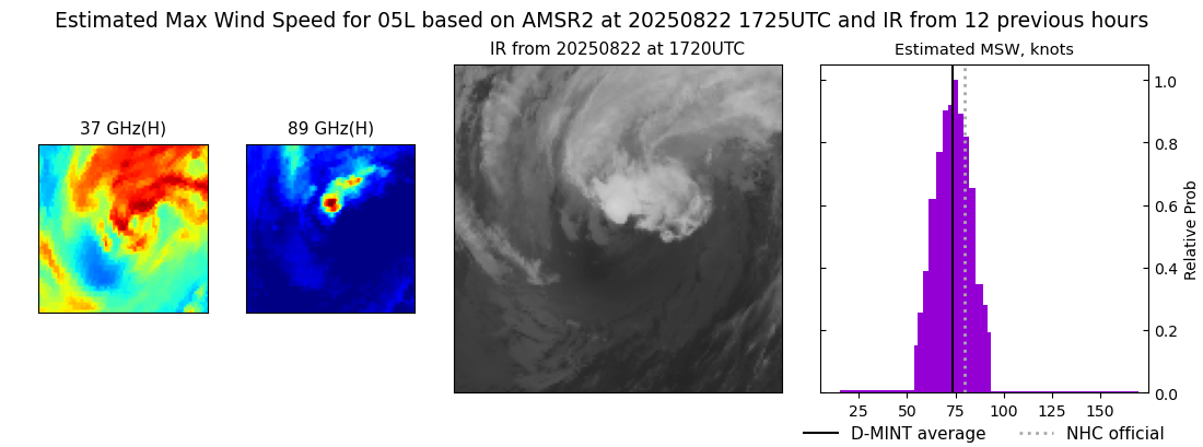
DMINT
|
| Date |
Time |
Vmax |
MSLP |
| 22Aug2025 |
1725UTC |
74 kts |
974 hPa |
| Vmax 25% |
Vmax 75% |
MW Instr. |
|
| 67 kts |
80 kts |
AMSR2 |
|
|
|
|
|
MW Sounders
|
| Date |
Time |
Vmax |
MSLP |
| 22Aug2025 |
1016UTC |
82 kts |
962 hPa |
|
|
|
|
SATCON
|
| Date |
Time |
Vmax |
MSLP |
| 22Aug2025 |
1140UTC |
70 kts |
972 hPa |
| Consensus Members |
| 2 (ADT+Sounders) |
|
|
|