|
Current Intensity Estimates
|
ADT
|
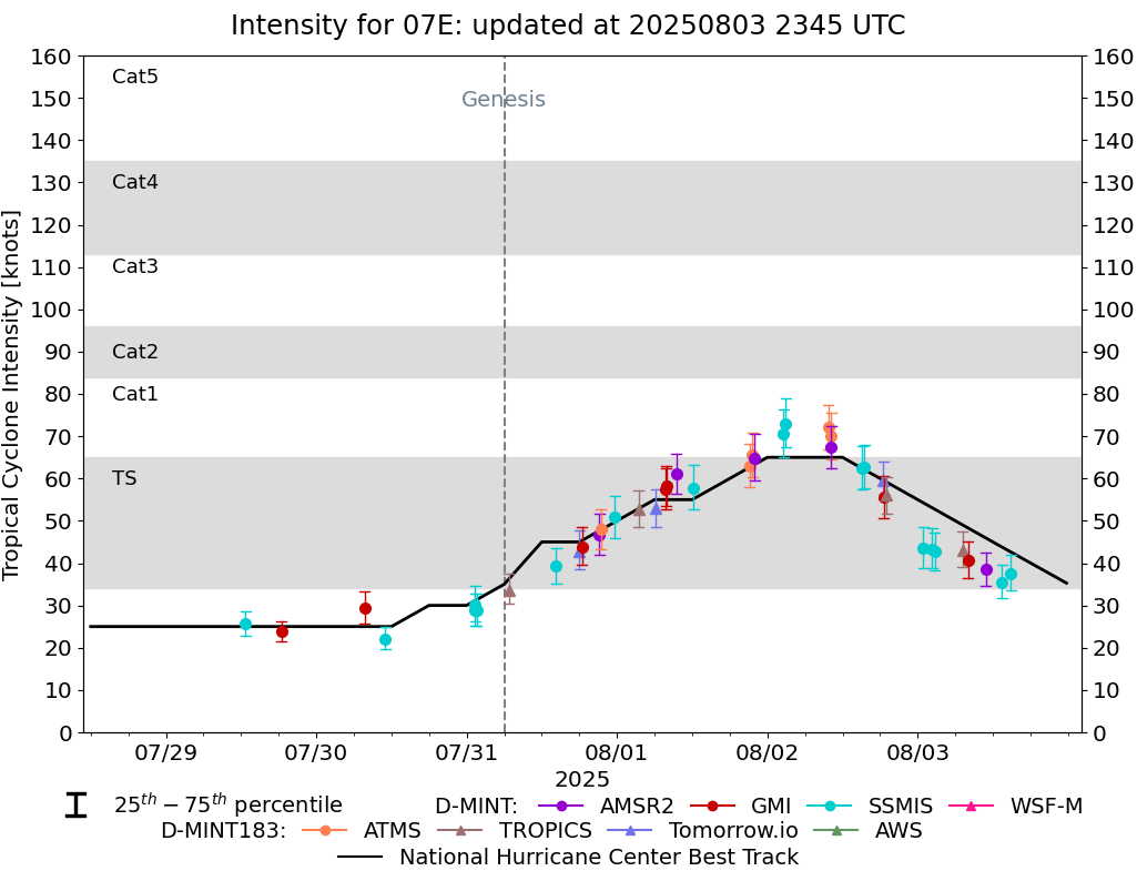
| Date |
Time |
Vmax |
MSLP |
| 03Aug2025 |
1440UTC |
31 kts |
1008 hPa |
| Scene |
CI# |
FT# |
AdjT# |
RawT# |
Eye T |
Cloud T |
| SHEAR |
2.1 |
1.5 |
1.5 |
1.5 |
17.31C |
8.41C |
|
|
|
|
AiDT
|
| Date |
Time |
Vmax |
|
| 03Aug2025 |
1440UTC |
36 kts |
|
|
|
|
|
DPRINT
|
| Date |
Time |
Vmax |
MSLP |
| 03Aug2025 |
1410UTC |
43 kts |
1005 hPa |
| Vmax 25% |
Vmax 75% |
|
|
| 39 kts |
48 kts |
|
|
|
|
|
|
DMINT
|
| Date |
Time |
Vmax |
MSLP |
| 03Aug2025 |
1326UTC |
35 kts |
1007 hPa |
| Vmax 25% |
Vmax 75% |
MW Instr. |
|
| 32 kts |
39 kts |
SSMISF18 |
|
|
|
|
|
MW Sounders
|
| Date |
Time |
Vmax |
MSLP |
| 03Aug2025 |
1103UTC |
45 kts |
999 hPa |
|
|
|
|
SATCON
|
| Date |
Time |
Vmax |
MSLP |
| 03Aug2025 |
1240UTC |
44 kts |
1005 hPa |
| Consensus Members |
| 2 (ADT+Sounders) |
|
|
|