|
Current Intensity Estimates
|
ADT
|
| Date |
Time |
Vmax |
MSLP |
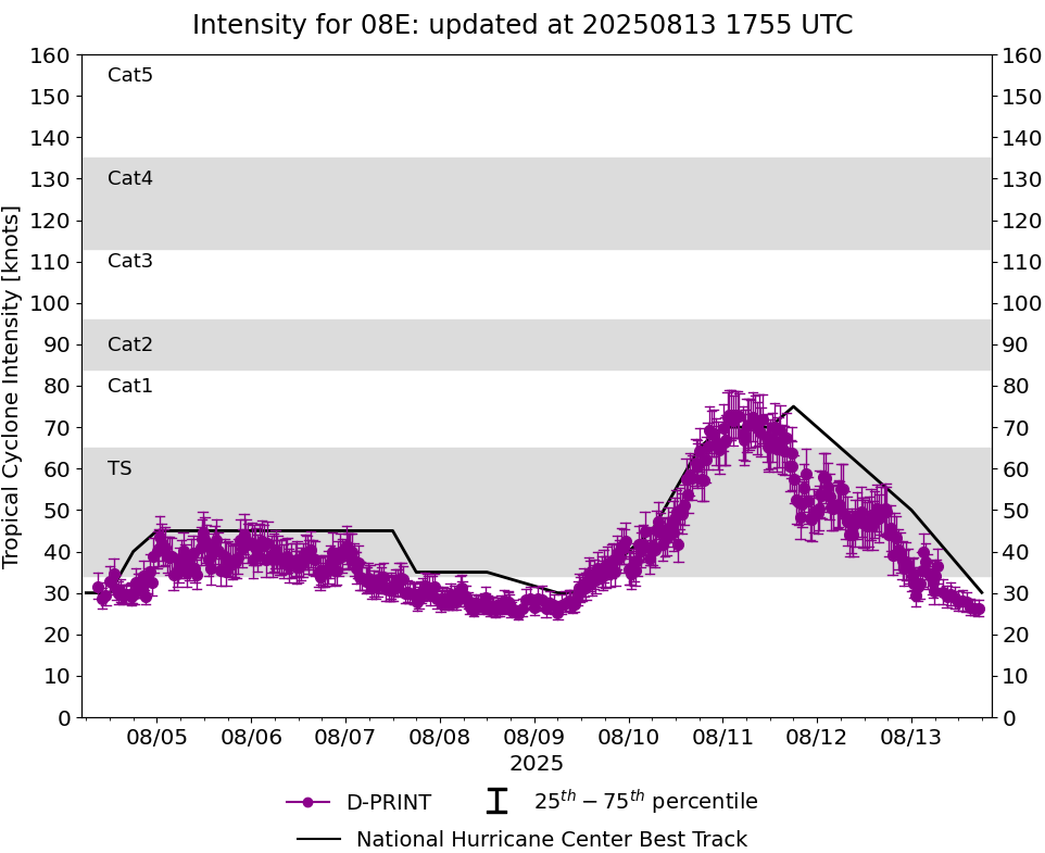
| 13Aug2025 |
0640UTC |
27 kts |
1010 hPa |
| Scene |
CI# |
FT# |
AdjT# |
RawT# |
Eye T |
Cloud T |
| SHEAR |
1.7 |
1.5 |
1.5 |
1.5 |
18.40C |
7.63C |
|
|
|
|
AiDT
|
| Date |
Time |
Vmax |
|
| 13Aug2025 |
0640UTC |
35 kts |
|
|
|
|
|
DPRINT
|
| Date |
Time |
Vmax |
MSLP |
| 13Aug2025 |
0640UTC |
36 kts |
1012 hPa |
| Vmax 25% |
Vmax 75% |
|
|
| 32 kts |
41 kts |
|
|
|
|
|
|
DMINT
|
| Date |
Time |
Vmax |
MSLP |
| 13Aug2025 |
0533UTC |
33 kts |
1009 hPa |
| Vmax 25% |
Vmax 75% |
MW Instr. |
|
| 30 kts |
37 kts |
SSMISF16 |
|
|
|
|
|
MW Sounders
|
| Date |
Time |
Vmax |
MSLP |
| 13Aug2025 |
0033UTC |
50 kts |
1002 hPa |
|
|
|
|
SATCON
|
| Date |
Time |
Vmax |
MSLP |
| 13Aug2025 |
0210UTC |
49 kts |
1003 hPa |
| Consensus Members |
| 2 (ADT+Sounders) |
|
|
|