|
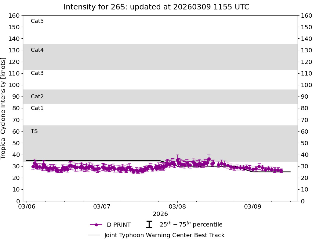
Current Intensity Estimates
|
ADT
|
| Date |
Time |
Vmax |
MSLP |
| 08Mar2026 |
1100UTC |
47 kts |
993 hPa |
| Scene |
CI# |
FT# |
AdjT# |
RawT# |
Eye T |
Cloud T |
| SHEAR |
3.1 |
2.7 |
2.5 |
2.5 |
15.63C |
0.33C |
|
|
|
|
AiDT
|
| Date |
Time |
Vmax |
|
| 08Mar2026 |
1100UTC |
42 kts |
|
|
|
|
|
DPRINT
|
| Date |
Time |
Vmax |
MSLP |
| 08Mar2026 |
1100UTC |
32 kts |
997 hPa |
| Vmax 25% |
Vmax 75% |
|
|
| 30 kts |
35 kts |
|
|
|
|
|
|
DMINT
|
| Date |
Time |
Vmax |
MSLP |
| 08Mar2026 |
0640UTC |
30 kts |
999 hPa |
| Vmax 25% |
Vmax 75% |
MW Instr. |
|
| 28 kts |
33 kts |
AMSR2 |
|
|
|
| Date |
Time |
Vmax |
MSLP |
| 08Mar2026 |
0634UTC |
33 kts |
998 hPa |
| Vmax 25% |
Vmax 75% |
MW Instr. |
|
| 30 kts |
36 kts |
ATMS-N20 |
|
|
|
|
|
|
MW Sounders
|
| Date |
Time |
Vmax |
MSLP |
| 08Mar2026 |
0634UTC |
41 kts |
991 hPa |
|
|
|
|
SATCON
|
| Date |
Time |
Vmax |
MSLP |
| 08Mar2026 |
0810UTC |
43 kts |
992 hPa |
| Consensus Members |
| 2 (ADT+Sounders) |
|
|
|