Return to Homepage
Cooperative Institute for Meteorological Satellite Studies / University of Wisconsin-Madison
Tropical Cyclone 12S (Jenna)
Latest Real-Time CIMSS Product Summary
Current Time :    
NHC/JTWC
Click on product name to access the full product homepage for each specific storm
Mouse over images to enlarge; click to view in window
Product Latency Color Code : Less than 3 hours old   3 - 6 hours old   6 - 12 hours old   Greater than 12 hours old   Not Available
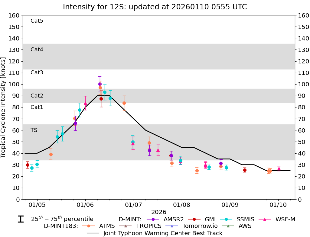
Current Intensity Estimates ADT
Date Time Vmax MSLP
09Jan2026 0445UTC 25 kts 1005 hPa
Scene CI# FT# AdjT# RawT# Eye T Cloud T
SHEAR 1.5 1.5 1.5 1.5 18.11C 15.16C
AiDT
Date Time Vmax  
09Jan2026 0445UTC 30 kts  
 
DPRINT
Date Time Vmax MSLP
09Jan2026 0500UTC 28 kts 1000 hPa
Vmax 25% Vmax 75%    
26 kts 31 kts    
DMINT
Date Time Vmax MSLP
08Jan2026 2204UTC 28 kts 1002 hPa
Vmax 25% Vmax 75% MW Instr.  
26 kts 30 kts SSMISF18  
MW Sounders
Date Time Vmax MSLP
08Jan2026 1930UTC 45 kts 999 hPa
  Satellite FOV  
  NOAA-20 32  
SATCON
Date Time Vmax MSLP
08Jan2026 2215UTC 41 kts 1000 hPa
Consensus Members
2 (ADT+Sounders)

RI Forecast AI-RI
Date Time Current Vmax Current MPI
08Jan2026 1800UTC 35 kts 9999 kts
20kt/12h 25kt/24h 30kt/24h 35kt/24h 40kt/24h 45kt/36h 55kt/48h 65kt/72h
0.1% 0.3% 0.0% 0.0% 0.0% 0.0% 0.1% 0.6%

Position Estimates ARCHER
Date Time Latitude Longitude
08Jan2026 1515UTC -17.44S 89.03E
Satellite Sensor Eye Diameter Eye Cert %
Metop-C ASCAT --- deg ---%

TC Structure MPERC
Date Time Prob. ERC onset
Full Model
Prob. ERC onset
V-based
08Jan2026 2200UTC 0% 0%
 
MIMIC-TPW  
MIMIC-TC  
Shear Analysis
Date Time Shear Magnitude
Shear Direction
09Jan2026 000UTC 12 kts 266 deg
Deep-layer vertical wind shear interpolated to storm center derived from the CIMSS AMV-aided analyses with vortex removed
TC-Scale AMVs